Showing posts with label stratigraphy. Show all posts

Friday, May 1, 2026

Across The Eparchean Unconformity

An unconformity is a gap in the recording of earth's history, similar to missing pages in a book. These breaks are more common than is realized. Stratigraphers, who organize geologic history, estimate that the time spans of non deposition exceed that of episodes of deposition. These gaps could be fleeting, as in a river meandering away and then reoccupying the old channel, or they could indicate conditions of non deposition and erosion lasting tens to even hundreds of millions of years.

Geologists recognize a hierarchy with the longer lasting breaks often pointing to major changes such as a mountain building phase accompanied by a prolonged sea level fall. As sediment deposition stops, erosion will often sculpt the top of the rock formation into an uneven surface. Eventually sediment deposition will resume. Geologists term such a break between the two phases of rock formation as an erosional unconformity.

Recently, the Geological Survey of India added the Eparchean Unconformity to its growing list of Geo-Heritage sites of national importance. This is one of those major long lasting erosional breaks seen in the Precambrian terrains of India. The chosen site is near Kalinjar Fort, in Banda District of Uttar Pradesh. Image Source: Geological Survey of India.

At this location, 1.2 billion year old sandstone of the Vindhyan Basin overlie 2.5 billion year old Bundelkhand granites marking more than a billion years of non deposition and erosion. While the amount of unrecorded time is significant, the real importance of this site is in the very different earth conditions represented by the older Bundelkhand granite as compared to the much younger Vindhyan sandstone. This unconformity marks the transition between the older Archean Eon and the younger Proterozoic Eon.

The Archean was a much hotter world. Melting of the earth’s mantle was producing large batches of silica rich magma which solidified to form buoyant continental crust, small rafts at first, growing into larger blocks as time went by. Vertical crustal movements created narrow depressions which got filled with lava and sediment eroded from nearby granitic highlands. These volcano-sedimentary successions were deformed and metamorphosed, and were preserved as enclaves within the granitic terrains.

By around 2.5 billion years ago, magmatic growth of continents petered out. Geologists estimate that around 70% of the present volume of continental crust was generated between 4 billion to 2.5 billion years ago.

As the mantle cooled, the more stable continental crust became the floor for a younger generation of sedimentary basins. The processes of chemical weathering and sediment transport became more prolonged on this wide gently subsiding continental terrain. As a result, waves and currents had more time to sort sediment by size, shape, and density before it was buried.

Thick deposits sorted by size into gravel, sand, and mud are the typical features of these younger basins. At places, ocean water saturated with calcium carbonate precipitated layers of calcite and aragonite sediment, preserved today as thick limestone. The biosphere was dominated by bacteria and unicellular eukaryotes, their morphology often imprinted on the rocks as wavy layers or as small mound shaped objects.

Magmatism and continental crustal growth continued less frequently in pulses coinciding with regions of plate convergence and orogeny. This phase, before large animal life evolved, lasting between 2.5 billion years and 539 million years ago is known as the Proterozoic Eon.

The newly listed National Geological Monument at Kalinjar Fort showcases these changing earth conditions.

For many decades though, exactly where to place the Eparchean Unconformity was something of a problem in Indian field geology. There was only sparse information on the absolute age of rocks and no consensus on the time span the Archean represented. Field mapping through Peninsular India indicated the presence of a distinct erosional break between deformed and metamorphosed rocks (crystalline basement) and younger flat lying or less deformed sediments. This appeared to be the natural horizon between the Archean and the Proterozoic.

But flat lying sedimentary sequences in different Indian basins, often referred to as Purana Basins, had been deposited at different times on older deformed rocks of varying ages. In some cases the foundation of the sub-horizontal sedimentary basins was indeed Archean. In other locations, the highly metamorphosed and deformed older rocks were actually Proterozoic. That meant that the Eparchean Unconformity, as earlier conceived, was not a useful marker of synchronous changes in earth processes. Many of these doubts are summarized early in this 1968 perspective on the Eparchean Unconformity by Dr. T V V G R K. Murthy, faculty at University of Sagar.

The dates for the Archean-Proterozoic transition have now been fixed at 2500 million years by the International Subcommisson of Precambrian Stratigraphy, without any condition regarding the rock type above and below the unconformity surface. As a result, the older criteria for identifying a particular erosional break as the Eparchean interval based on only rock types and extent of deformation was no longer tenable.

We finally have an answer for the question posed by Dr. Murthy so long ago:

“Does the eparchaean unconformity become evident by recognizing Archaean and Purana formations or are the Archaean and Puranas recognized by identifying the eparchaean unconformity”.

Today, better absolute dating of rocks makes differentiating Archean from Proterozoic rocks easier. The Eparchean Unconformity though is still an informal but useful term in Indian field geology signifying the cooling trajectory of the earth’s interior, with a hotter Archean transitioning to a cooler Proterozoic.

One of my earliest encounters with the Eparchean Unconformity occurred during my graduate studies. I was assigned to map an area of the Cuddapah Basin near Gani village in Andhra Pradesh, South India. I first traveled by the Dadar -Madras (now Chennai) Express to Guntakal. There, I transferred to a medium gauge train passing through small market towns connecting a vast hinterland an urban kid like me was unfamiliar with. The train chugged along eastwards towards Nandyal. For a couple of hours from Guntakal, we were firmly on Archean terrain, an agricultural landscape interrupted by small hillocks of granitic rocks. In a distance through the late morning haze we could see the low Cuddapah hills with their distinct tilted strata.   

The train crossed the Eparchean Unconformity and entered the Proterozoic through a breach in the Cuddapah hills at Dhone Junction. Ahead was the Cuddapah Basin stretching to the horizon.

We moved through quartzites, limestone, and shale, the three predominant sedimentary rock types of the shallow marine Proterozoic continental shelf. At Nandyal I had to hop onto a bus going to Kurnool. Gani village was midway between these two places. I remember arriving at Gani late evening to a warm welcome by my host Mr. Sivanand Rao. Next morning, with maps and aerial photos, hammer, and a geologic compass I started out. A half hour walk south of Gani were outcrops of the sedimentary rocks I had to map. It was a challenging and immensely satisfying introduction to field geology.

Picture shows a very youthful me and my field guide Yanganna standing in front of a quartzite hill. Captured by my accompanying batch mate Nitin Rane. June 1987.


Someday soon I hope to retrace my steps to little Gani village. The medium gauge tracks from Guntakal to Nandyal have long been replaced by standard gauge. Express trains pass through Nandyal, eventually swerving north towards Vishakapatam, or continuing south east towards the Coromandel Coast.

From Nandyal I may hire a car to Gani. I hope to meet Mr Sivanand Rao who so graciously hosted me over two field trips. I want to walk again towards the hills made of Paniam Quartzite, a sand deposit sorted and washed clean by powerful Proterozoic tides. Today, the Kurnool-Gani solar park stands near Gani, its tilted solar panels made up of ultra pure silica wafers making up an Anthropocene analogue of the more ancient quartz rich deposits.

Photomicrograph shows the Proterozoic Paniam Quartzite classified as a “super mature quartz arenite”. Notice the well rounded quartz grains outlined by iron oxide. Location - Gani anticline.

Beyond the quartzite hills are the Vempalle Formation dolomite, a vestige of the Proterozoic ocean I first waded in to begin my life long association with carbonate sedimentology. It will be a home coming of sorts for me.

Photomicrograph shows microbial layers in the Vempalle dolomite. Dolomite crystals of different size and shape have replaced the original organic mats. Location- Gani anticline.

I have one more incentive to relive this journey. The filter coffee at Guntakal railway station canteen. It is the very best.

Friday, October 31, 2025

Deccan Traps: Thickness And Elevation

I recently read Peter Brannen’s excellent book “The Ends of the World: Volcanic Apocalypses, Lethal Oceans And Our Quest To Understand Earth's Past Mass Extinctions”. He has packed quite a few details on the geologic triggers and ecologic upheavals the earth has witnessed from time to time, resulting in the episodic reorganization of the earth’s biosphere.

In the chapter on the Late Cretaceous mass extinction he writes, referring to the Deccan Basalts, .. “today in Western India, 11,500 -foot-tall bar-coded mountains, like the jagged banded peaks of Mahabaleshwar have been carved from this surfeit of molten rock”.  He presents a lively discussion on what impact such a prolonged phase of volcanism could have had on environmental health and biodiversity. 

The view below of a section of the Deccan Basalts at Warandha Ghat, SW of Pune city, illustrates nicely the 'bar coded mountains" that Brannen mentions. 


Repeated effusion of lava which spread rapidly away from eruptive vents has produced the distinct layered architecture.  Differential weathering of softer and hard layers produces intermittent rubbly vegetated slopes alternating with scarps resulting in a "bar coded" edifice.

But what about the 11,500 foot tall reference? "Tall" will be read by most as elevation. That is a curious number since the "jagged banded peaks" of the popular hill station of Mahabaleshwar are around 4700 feet high. The highest region in the Deccan Volcanic Province is Kalsubai near Nasik, standing at 5400 feet.

Why such a large discrepancy between Brannen and the measured elevation in the Deccan Volcanic Province? I suspect what Brannen is referring to is a composite stratigraphic thickness of the lava in Western Maharashtra. Refer to the table below. It presents two different approaches to organizing the lava pile into discrete units. 

 Source: Vivek S Kale and coworkers 2017- Geological Society of London, Special Publications. 

"Lithostratigraphy" relies on systematic physical differences in lava packages to classify them into formal units. The "Chemostratigraphy" classification uses chemical differences in successive phases of eruption to subdivided the lava pile. 

Add up the thickness of the individual units and you end up with a 3400 meters or 11,150 feet thick section of lava. Branner may have used a slightly different estimate of lava thickness to arrive at a 11,500 foot thickness for the Deccan Basalts. 

If, as seen in the section at Warandha Ghat, the lava is nearly horizontally disposed, why then is the stack of lava "only" 4700 feet at Mahabaleshwar and caps out at 5400 feet at Kalsubai? 

The answer is in the way the different subunits of the lava are exposed all across the volcanic province. The map below shows sections of the Deccan Traps at different locations.


Source: L Vanderklyusen and coworkers 2011- Journal of Petrology.

In this map, the chemostratigraphic subdivisions are shown. What is important is that all the subunits never stack up in any one place. The reason is in the regional structure of the volcanic pile. It is in the form of a gently waveform with younger packages of lava offlapping towards the south. 


Source: M. Widdowson and K.G. Cox 1996: Earth and Planetary Science Letters.

This north to south cross section of the Deccan Traps along the Western region shows how different subgroups are exposed along the profile. You can see how at any one place the lava thickness and altitude is between 1000 to 1500 meters ASL.

It is important to mention that this is a regional view of the lava section across a distance of around 650 km depicted with a 40x vertical exaggeration.  The inclination of the lava layers is very subtle and has been deduced from careful measurements of the altitude of the subunit boundaries at different locations along the profile. 

The section below shows a close up of the lava stratigraphy along two north to south profiles in mid Western Maharashtra in the well known Harishchandragarh - Bhimashankar area. Notice again how only a few of the units stack in any one location.  


Source: Vivek S Kale and coworkers 2017- Geological Society of London, Special Publications.

Why did such an arrangement of the lava units emerge? Is the waveform a regional volcanic dome with lava radiating from one central eruptive center? Or is it due to post-eruption arching of the crust? Have younger lava sections been removed by erosion from the northerly locales, or has there been a southerly migration of eruptive centers over time, resulting in the offlapping arrangement? Anne E. Jay and Mike Widdowson in a study published in the Geological Society of London estimate that as much as 1.5 km of lava section has been removed by erosion from the Nasik area. That region would have stood much taller tens of millions of years ago. We will leave these questions lingering for another time. 

What I do wish is that Mahabaleshwar really stood 11,500 feet tall. I could have ice skated on Lake Venna. 

Tuesday, July 4, 2023

Chronostratigraphy: Beats Of The Geological Time Scale

The International Commission of Stratigraphy has published an updated chronostratigraphic chart.

You can download a high resolution pdf as well as a jpg version. 

This is a good resource if you want to know the time spans for all those hard to pronounce units that geologists keep referring to in their talks and articles. 

The columns in the figure are hierarchical divisions of geologic time based on the rock record. Take for example the columns on the extreme right. Proterozoic Eon is an interval of time defined by rocks that formed between 2.5 billion years ago and ~539 million years ago. The Neoproterozoic Era is a subdivision defined by rocks formed between 1 billion years ago and ~539 million years ago. And the Ediacaran Period is a time unit represented by rocks formed between 635 million and ~539 million years ago. A significant change occurred around 539 million years ago. Shelly fossils began appearing in the rock record. This marks the end of the Proterozoic and the beginning of the Cambrian Period.  

Notice something interesting? 

Take a look at the internal divisions of the Archean and the Proterozoic Eons. The Archean is divided into fairly uniform 400-300  million years units, while most of the Proterozoic is divided into roughly 200 million years units.

In contrast, the Phanerozoic Eon subdivisions have unequal age spans. By around 550 million years ago, unicellular and multicellular creatures evolved the ability to build hard skeletons made up of calcium carbonate, calcium phosphate, and silica. This resulted in better preservation of their remains in the rock, giving geologists the ability to track evolutionary changes. The boundary between different subdivisions you see on that chart is a recognition of the appearance of a new species or species assemblage. Evolution's clock has an irregular beat, making for unequal chrono units.

More uncommonly, boundaries are defined by chemical shifts that mark a change in the earth's environment. For example, the newest subdivision of the Quaternary Period, the Meghalaya Age, is recognized by shifts in the oxygen isotope composition of stalactites from a cave in Meghalaya, signalling global drought events beginning 4.2 thousand years ago.

The Precambrian was a microbial world. Microbes too were undergoing continual evolutionary changes, but they did not build hard skeletons and their tiny soft remains don't preserve well at all. Geologists can't use microbial evolution to subdivide the Archean and the Proterozoic. There are no systematic temporal changes in rock types as well.

The boundary between the Archean and the Proterozoic does represent a significant transition in earth processes. It marks a shift from a hotter and more tectonically active Archean to a cooler earth, where large rafts of continents had formed. Many sedimentary basins that developed on this continental crust did not undergo the intense deformation and metamorphism observed in Archean sedimentary and volcanic rock associations. But, like the Archean, through most of the Proterozoic too, there is no uniquely changing fossil record to act as anchors for subdivision. 

By around 700 million years ago, rapid global changes in climate and the evolution of larger organisms has allowed for a finer resolution of the rock record. Both the Cryogenian, which preserves signals of widespread glaciations, and the Ediacaran, with a better fossil record of larger multicellular creatures, are smaller subdivisions of the Proterozoic.

Through my geology career, I have been lucky to have worked on rocks from across the time scale.  My M.Sc. thesis was on Orosirian, Statherian and Tonian age rocks from the Proterozoic. My Ph.D research was on Katian and Hirnantian age rocks from the Ordovician Period. And I have done smaller projects on the Oxfordian of Jurassic, and some imprecisely dated rocks from the Eocene Period.


Friday, June 17, 2022

That Day 66 Million Years Ago

Just wanted to share this abstract of a paper detailing an outcrop from Baja California, Mexico, which preserves heterogeneous deposits resulting from the Chicxulub meteorite impact 66 million years ago. 

We report K-Pg-age deposits in Baja California, Mexico, consisting of terrestrial and shallow marine materials re-sedimented onto the continental slope, including corals, gastropods, bivalves, shocked quartz grains, an andesitic tuff with a SHRIMP U-Pb age (66.12 ± 0.65 Ma) indistinguishable from that of the K-Pg boundary, and charred tree trunks. The overlying mudstones show an iridium anomaly, and fungal and fern spores spikes. We interpret these heterogeneous deposits as a direct result of the Chicxulub impact, and a mega-tsunami in response to seismically-induced landsliding. The tsunami backwash carried the megaflora offshore in high-density flows, remobilizing shallow marine fauna and sediment en route. Charring of the trees at temperatures up to >1000°C took place in the interval between impact and arrival of the tsunami, which on the basis of seismic velocities and historic analogues amounted to only tens of minutes at most. This constrains the timing and causes of fires, and the minimum distance from the impact site over which fires may be ignited.

Raging forest fires, a tsunami and its backwash, hundreds of millions of tons of sediment mobilized as gigantic mixed debris flows, ecosystems laid waste.

What a catastrophic time! 

The paper is open access but be aware that it is a preprint, yet to be peer reviewed. 

Forest fire at the K-Pg boundary on the Pacific margin of Baja California, Mexico: timing and causes- Amanada Santa Catharina et.al. 2022.

Tuesday, February 22, 2022

Marking Vindhyan Time

About this time last year I wrote a piece for Nature India on the discovery of the fossil Dickinsonia from the uppermost Vindhyan strata exposed at Bhimbetka caves in Central India. Dickinsonia is considered to be an early animal that lived between 560 to 550 million years ago. This finding seems to confirm an Ediacaran age  (635-541 million years ago) for the youngest Vindhyan strata, termed formally as the Bhander Group. Earlier thinking was that these rocks are 1000 to 900 million years old! 

I have been thinking on and off about this discovery, not as much doubting it as trying to understand its implication from a different angle, that of the ways in which sediments accumulate in a basin and how the passage of time is recorded in sedimentary successions. 

The sedimentary rocks of the Vindhyan Basin have been subdivided by field geologists into four units based on characteristic sediment associations. From the oldest to the youngest, these are, the Semri Group, the Kaimur Group, the Rewa Group, and the Bhander Group.  Deposition of the Semri sediments began around 1700 million years ago and ended by 1600 million or so. Tectonic movements then uplifted, tilted, and eroded these rocks. Between 1200 million and 1100 million years ago the basin floor subsided and new sediment was deposited on the inclined layers of the Semri Group. There is thus a marked  'angular unconformity' between Semri and the overlying Kaimur strata, marking two distinct phases of basin history separated by 400 million years.

The age of Kaimur, Rewa and Bhander Groups, which are often referred to as the Upper Vindhyans, has been more difficult to pin down due to a lack of reliable radiogenic dating and age diagnostic biota. Despite this, a combination of magnetic properties, a few Uranium series dates from limestones, and the age ranges from zircon found in Bhander sandstones,  hinted that the youngest Vindhyan sediments are about 900 million years old.

The fossil Dickinsonia has upended this assumption and appears to have expanded the life of the Vindhyan Basin by a whopping 350-400 million years. This revision has been bolstered by two other age criteria. Microbial fossils typical of the Ediacaran Period have been reported from the Bhander. And secondly, in the year 2020, a detrital zircon dated to 548 million years ago was recovered from the Bhander. Zircons form in magmas or during high temperature metamorphic reactions. The mineral is then eroded away from these source rocks and deposited as a sedimentary particle in adjacent basins. The youngest zircon population in a sedimentary layer sets its maximum age,  since the strata cannot be older than the detritus it is made up of. It could be much younger than the contained zircon, but in this case a lack of Cambrian fossils has constrained the age of the Bhander to be older than 541 million years ago.

Let me now dive in to what has been pricking my geological curiosity. The Kaimur, Rewa and the Bhander are thought to be three distinct episodes of sedimentation. Stratigraphers may recognize them as 'depositional sequences' formed when accommodation space for sediment to accumulate is being created either by the basin floor sinking due to tectonic movements or due to eustatic (global) sea level changes. 

Such depositional sequences are building blocks of sedimentary successions in basins of all ages, each episode lasting at most few tens of million of years. V.S. Kale in a discussion note on Indian Purana basins points out that the physical characters of the sediments are not suggestive of slow sedimentation rates, and given their thickness, estimates that these sequences span 10-20 million years each. Even assigning the upper limit, Kaimur, Rewa and Bhander were deposited in about 60 million years or so. If Upper Vindhyan sedimentation began around 1200 -1100 million years ago and ended by 550-540 million years ago, that leaves about 550 million years of unrecorded elapsed time.

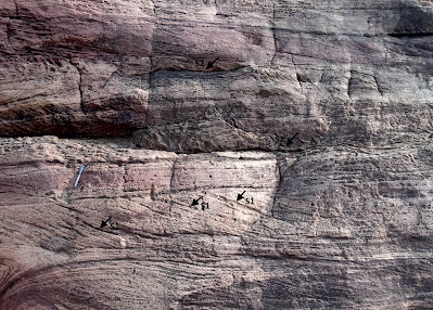
Sedimentation is an inherently episodic process with periods of non-deposition alternating with sediment accumulation. See this close up of an outcrop of a cross bedded sandstone from the Badami area in Karnataka.  


These sediments were deposited in a long lasting river system. Surfaces that result from non-deposition are marked as S1, S2.  In this hierarchical scheme, S1 spans perhaps a few minutes to a few hours and is a break in deposition on the lee side of  migrating ripples due to fluctuations in current energy. The S2 surface has developed over the channel sand body and spans months to years and represents seasonal fluctuations in currents or even a long drought which dries up the channel. 

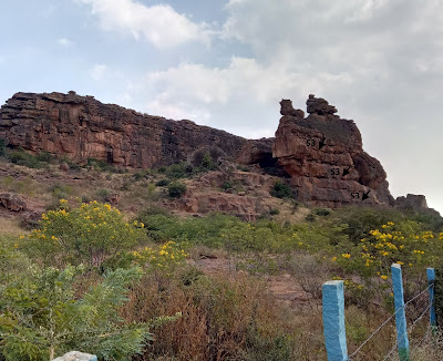
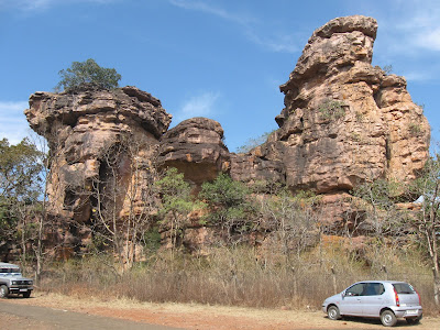
 Now, cast  your eye on this larger outcrop of the Badami sandstone. 

 
It has formed by the stacking of smaller sandstone units, each containing several surfaces of non deposition. The higher order surface S3 in this thicker pile marks a longer period of non-deposition and indicates a shift in course of the river channel. Hundreds, even thousands of years will pass, before the channel migrates back to its original location and deposition resumes at that locale.

Although I may be amiss in my specific interpretation of these surfaces of non-deposition, what I want to convey is that sediment deposition in all types of environments is interrupted by periods of non-deposition ranging from a few minutes, to thousands, even millions of years. The vast majority of elapsed time a sedimentary succession represents may be accounted for by periods of non-deposition and erosion. 

The Kaimur, Rewa and Bhander collectively account for a 60 million year time-span. If the revised age range for the Upper Vindhyans is correct then there were gaps of hundreds of millions of  years between the deposition of these Groups.

But these very long breaks invariably result due to tectonic uplift and cause pronounced erosion and chemical alteration of the exposed sedimentary surface. In outcrop it is recognizable as an undulating surface with the debris of weathering consolidated into hard soils, and in the formation of solution pits in limestone terrains. Such basin wide surfaces of marked erosion have not been found separating the Kaimur and the Rewa, and between the Rewa and the Bhander strata. 

Smaller breaks though do occur. Chandan Chakraborty in a study of sedimentary cycles of the Vindhyan Basin finds an angular discordance between the Kaimur and the Rewa, and the Rewa and the Bhander. However, this is restricted only to the south of the Vindhyan Basin. The discordance between the older and younger sequences dies out towards the north. This stratigraphic relationship  suggests that the tectonic movements were contemporaneous with sedimentation. The basin floor was tilted up on one side interrupting sedimentation and eroding the exposed strata there, while at the other end (north), subsidence and deposition continued. The periods of non-deposition and erosion between these sequences was a more localized event, lasting few millions of years at most. The kind of tectonic upheavals that may halt deposition for hundreds of millions of years across the entire basin are simply not attested to in the stratigraphic record of the Upper Vindhyans. 

It seems to me, and I say this mischievously, that the earlier estimate of 1000-900 million year age of the uppermost Bhander strata and for the end of Vindhyan sedimentation sounds quite reasonable! 

How secure is the finding of Dickinsonia and the assigned Ediacaran age of the Bhander Group? I am in no way trying to rebut this finding. The microbial fossil Arumberia found in the Bhander is considered by experts to be a reliable Late Ediacaran age indicator. However, the identification of Dickinsonia is based on a 3D digital reconstruction of photographs taken at the site of discovery. Due to the protected status of the Bhimbetka Caves, the scientists were unable to excavate the impression and subject it to a physical examination or a chemical test for organic residue. This is the only report of Dickinsonia from the entire Vindhyan Basin.

The young 548 million year date of the detrital zircon is based on one grain. The researchers are confident of their analysis and see no reason to reject this data point, though they admit that further corroboration of this date will be necessary given that previous studies did not report such young zircons from the Bhander strata. Curiously, no source terrain of this young zircon is identified in the paper.  

The news about Dickinsonia received wide coverage in India. That was expected given the long standing uncertainty of the age of the Vindhyans and the importance of the fossil for understanding early animal evolution and Ediacaran ecology and paleogeography.  But these new proposed timelines have thrown up a puzzle about rates of accumulation of sedimentary sequences and magnitudes of intervening breaks. We are quick to appreciate changes in sedimentary layer color, their structures, and their geometry, and interpret these changes in the context of fluctuating depositional conditions. But what about surfaces of non-deposition? Do they have anything valuable to contribute to our understanding of geological processes. 

The paleontologists Niles Eldredge and Stephen Jay Gould once perceptively observed that 'stasis is data'. The unchanging morphology of many fossil species lineages tell us something about the mode and tempo of evolution. Geological surfaces of stasis, when sedimentation has come to a standstill, are richly informative too in their own way. Surfaces representing very long time-spans may develop during convulsions in the earth's crust and periods of mountain building. The soils that often mantle such surfaces archive information about past climate and terrestrial life. Breaks of smaller and smaller time-spans like wise have a variety of drivers such as orbital control on climate and sea level, migration of depositional environments, and even tidal cycles.  

How many more hiatuses of unknown duration lie hidden within the Vindhyan sediment pile?  They may mark phases when no sediment accumulated but they are as much an integral part of basin history as are the iconic sandstone faces of Bhimbetka.


Thursday, July 15, 2021

Fire Initiated The Anthropocene

James C. Scott in his book Against The Grain: A Deep History of the Earliest States makes the case for the transformational impact of fire on our environment.

" Hominids' use of fire is historically deep and pervasive. Evidence for human fires is at least 400,000 years old, long before our species appeared on the scene. Thanks to hominids, much of the world's flora and fauna consist of fire adapted species (pyrophytes) that have been encourage by burning. The effects of anthropogenic fire are so massive that they might be judged, in an evenhanded account of the human impact on the natural world, to overwhelm crop and livestock domestication. Why human fire as landscape architect doesn't register as it ought to in our historical accounts is perhaps that its effects were spread over hundreds of millennia and were accomplished by "precivilized" peoples also known as "savages". In our age of dynamite and bulldozers, it was a very slow-motion sort of environmental landscaping. But is aggregate effects were momentous."

The impact of human activity on the earth's outer skin has been so considerable that atmospheric chemist Paul Crutzen proposed that we are now living in a new geologic epoch, which he called the Anthropocene. This has sparked a vigorous debate on whether a new division of our time scale is justified, and if it is, on where to place its beginning. James C. Scott make a distinction between what he terms the "thick" Anthropocene, contrasting with the idea of a  "thin" Anthropocene. 

A "thick" Anthropocene is manifest by a sudden appearance of a worldwide signal of human activity. Examples of this could be the advent of the Industrial Revolution, or even more catastrophically, the nuclear age in the 1940's which left global radioactive markers.  The "thick" Anthropocene appears to fit more closely geologic convention which demands that the beginning of a new geologic time unit need be recorded by a widespread and more or less synchronous preservation of biological and chemical changes. 

Scott calls fire, agriculture, and domestication as part of the complex that comprises a "thin" Anthropocene. These inventions changed the world patchily and slowly. Its signals appear here and there, not encoded in one geologic layer, but in many, smeared over the past few hundred thousand years. 

The term "more or less synchronous" I used to describe a new geologic boundary is relative to where in the geologic past the observer is. More recent changes are resolvable to a finer degree either as a matter of historical record or by methods like counting tree rings and annual/decadal growth layers in stalactites, cross calibrated by either carbon dating or some other radiometric dating method. The error bar increases as one goes further back in time. Take the great mass extinctions of the past. There will be a sediment layer to which a geologist can point to and state that this marks the boundary between say the Ordovician and the Silurian or the Permian and the Triassic. But that sediment layer certainly wasn't deposited instantaneously. It likely represents a few thousand years of elapsed time. If you were an observer who spent a few years in the Late Ordovician 443.8 million years ago, the situation would have been more akin to Scott's "thin" Anthropocene, with small changes occurring at different times in different places. You would have been unlikely to have anticipated the profound cumulative shift that would eventually accumulate.

Most mass extinctions which form the basis of the big divisions of geologic time unfolded over thousands of years, but their material record is collapsed into a few feet of sediment. We perceive these geologic turnovers as 'sudden' because the preceding and succeeding periods of relative stability lasted tens of  millions of years and the time the 'boundary layer' spans is unresolvable using our current dating methods.

The exception to this is that fateful day 66.03 million years ago, when a large meteorite struck what is now the Yucatan Peninsula. By the time the dust had settled (literally) in a few weeks, the world had irrevocably changed. The Cretaceous-Paleogene boundary layer is in an absolute time sense a truly instantaneous deposit. We interpret it as instantaneous, not by radiometric dating, but by using our understanding of the physical sedimentation processes that would have been triggered by the impact.

The lesson we can draw from the transformational events from deep geological time is not about the debates over the timing of Anthropocene but on its effect. Like those distant ecologic disruptions, we too have set off biological, chemical and physical processes on a different trajectory than they were several thousands of years ago. The Anthropocene will leave a permanent mark on the many future worlds to come.

Monday, May 3, 2021

Cretaceous Cauvery Basin Stratigraphy

In the second year of my bachelor's degree course, a few of us friends had gone fossil hunting near the town of Ariyalur in Tamil Nadu. Ariyalur sits on Cretaceous age sediments deposited in a basin that formed as India broke away from Antarctica and Australia. The basin got filled slowly over time, by sediments brought in by rivers, as well as in the marine realm, as the sea episodically kept encroaching on to the continent interior. 

Before leaving for the trip we had approached Dr. V.D.Borkar, a research scientist with the Agarkar Research Institute in Pune, to help us plan the fossil collection. He very generously lent us maps and gave us a detailed idea of the villages to travel to and nearby field locations. 

All in all it was a fun field trip. We roamed the countryside around Ariyalur and collected plenty of fossils. In our collection were plant impressions on clay, ammonoids, belemnites, echinoids, coral fragments, and a variety of bivalves. The non geology highlight was the absolutely delicious vegetarian thali meal served in the canteen next to the town bus station! We used to gorge on it everyday, twice a day.

At that time I didn't have a good understanding of stratigraphy and even sedimentary geology. As it happened I did not grasp the broader implications of the distribution of particular fossils and the arrangement of strata that I was observing in the field. 

Its never too late to update yourself! The past month I have been reading three papers on the Cretaceous outcrops around Ariyalur which focus on basin development and stratigraphic evolution. In simpler language, stratigraphic evolution means the patterns by which basins fill up. A closer look reveals that basins are not made up of uniform continuous layers (layer cake stratigraphy) of one sediment type succeeding another, but rather there is lateral interfingering of different types of sediment, controlled by sediment distribution patterns, water energy, and basin topography.  

There are exogenous influences too. A long term drop in sea level will result in a particular arrangement of strata known as 'progradation', formed for example when deltas build out in to the sea. This may be followed by a long term sea level rise forming an overlay of a different sedimentary pattern, called  'retrogradation'. In this case as the sea encroaches on land, coarser sediments that are deposited closer to the shore get buried under deeper water fine grained sediments  A sedimentary section from base to the top (older to younger) reveals in its sediment characteristics these changing environmental conditions.

Documenting these patterns in not as esoteric an exercise as it may seem to some. Such analysis is very keenly taken up during petroleum exploration.  One may find during outcrop mapping that coarse sand deposits (potential petroleum reservoirs) occur at repeated intervals and are juxtaposed against finer organic rich mud rocks (potential hydrocarbon source rocks). This then may become a guide for optimizing detailed exploration strategy in areas of the basin where strata are buried and can't be observed directly. Just such a situation occurs in the Cretaceous Cauvery Basin. The sediments around Ariyalur is one of the main accessible outcrops. But further to the east, these sedimentary layers continue under the sea bed of the Bay of Bengal. A well documented and well understood outcrop provides an analogue for the unseen portions of the basin.

These three papers clarified to me much of the Cretaceous stratigraphy that I had failed to understand in my college days.

Here are the links:

1) Cretaceous tectonostratigraphy and the development of the Cauvery Basin, southeast India: Matthew P. Watkinson, Malcolm B. Hart and Archana Joshi

A broad study of basin formation by continental rifting and the resulting patterns of basin infilling interpreted in the context of tectonic events, major sea level fluctuation and depositional episodes.

2) Sea level changes in the upper Aptian-lower/middle(?) Turonian sequence of Cauvery Basin, India  An ichnological perspective: Amruta R. Paranjape, Kantimati G. Kulkarni, Anand S. Kale.

Ichnology is the study of trace fossils. These are tracks, trails and burrows made by the movement of  creatures living on the basin floor. Traces differ depending upon the nature of sediment substrate and environmental conditions and can be used along with other sedimentological and fossil data to interpret patterns of sea level change.,

3) Siliciclastic-carbonate mixing modes in the river-mouth bar palaeogeography of the Upper Cretaceous Garudamangalam Sandstone (Ariyalur, India): Subir Sarkar, Nivedita Chakraborty, Anudeb Mandal, Santanu Banerjee, Pradip K. Bose.

The Garudamangalam Sandstone formed during a sea level highstand i.e. at the peak of a sea level change cycle, when the rate of sea level rise finally slows down and stops. Sediment transported by east flowing rivers began building a delta. The exposed Garudamangalam Sandstone is part of this delta complex. This is a very nice analysis of sedimentary processes and products. The various subenvironments in this delta complex are identified and the chemical changes in the sediment after their deposition are documented using various techniques like chemical staining and cathodoluminescence. I really enjoyed reading this one!

On a personal note, the Covid catastrophe unfolding in India is making reading and writing difficult. However, I did find that a few hours of geology time that I am managing to hold on to brings me some comfort. 

Wednesday, January 27, 2021

Fossil Dickinsonia Indicates Ediacaran Age For Upper Vindhyans

 It looks like one of the long running debates in Indian stratigraphy has been resolved. 

The Vindhyan Basin is one of several Proterozoic age basins in Peninsular India. The youngest rocks in this basin have been accepted to be of Neoproterozoic age i.e. less than 1 billion years old. But absolute dating of these rocks is tough. Criteria like youngest detrital zircon ages, which tell us the age of the youngest source rocks from which sediments were derived, were hinting at an age of about 850- 900 million years for the uppermost Vindhyan strata. On the other hand, presence of fossils like Arumberia and Beltanelliformis minuta, both considered microbial organisms, were suggesting of an Ediacaran age (637-541 million years) for youngest Vindhyan rock units, although there wasn't a widespread acceptance of these dates. Then, last year, a paper by Lan and colleagues published new detrital zircon dates of 548 million years from the Maihar Sandstone. They indicated that the uppermost Vindhyans are late Ediacaran in age. Detrital zircon age tells us that the sediment cannot be older than the zircon, i.e. it gives a maximum age for the deposition of the sedimentary layer.

Now, a stunning fossil find seems to confirm this chronology. The Ediacaran age fossil Dickinsonia has been dated to about 555 million years from sites in Russia. This fossil was found as impressions on Maihar Sandstone at the site of Bhimbetka in Madhya Pradesh. Bhimbetka caves are famous for pre-historic cave art. Gregory Rettalack and colleagues report Dickinsonia, in their own words.. " hiding in plain sight, on the roof of the Audi-torium Cave (N22.938402° E77.613504°), the first of several Paleolithic and Mesolithic cave painting and petroglyph sites on the path into Bhimbetka Rock Shelters"..

The fossils remain in place at the site as negative relief impressions and has been documented photographically (pics below).


            Source: Retallack G. et.al., 2021: Dickinsonia discovered in India and late Ediacaran biogeography.

The biological affinity of Dickinsonia is contested. Some paleobiologists think it is a representative of an extinct group of early animals. Others think it is likely to be a macro algae. No unequivocal indicators of animal life, either in the form of body or trace fossils, has been found in the Vindhyan Basin so far. Such a recent age for the uppermost Vindhyan strata may renew hope that the earliest stages of animal evolution are preserved in these rocks. 

I had written a long post on the age problem of the upper Vindhyans some time back. In that I had mentioned that physical signals like magnetic signatures and chemical criteria like carbon isotope trends were suggestive of the uppermost Vindhyans being not much younger than 850 million years. But similar magnetic signals and carbon isotope trends may be repeatedly produced under similar physical and chemical conditions.

Fossils are a better guide to age. Evolution produces unique life forms. Species exist over a restricted time range. This is the basis for constructing a relative time scale for global strata. Presence of the same species or same group of organisms in physically disconnected rocks indicate contemporaneity of these units. To ascertain their absolute age they need to be dated using one or more of radiogenic dating methods, usually relying on interlayered volcanic ash which contains the  appropriate minerals. Or, as in this case, using detrital zircon, which gives us the maximum age of the unit.  Global surveys of late Neoproterozoic strata show that Dickinsonia is not found in rocks younger than about 550 million years. This brackets the age range of the Dickinsonia containing unit of the Maihar Sandstone at Bhimbetka to between 555 -550 million years. Detrital zircon ages of 548 million years for Maihar Sandstone indicate that Vindhyan sedimentation continued for some time after.

I find myself compelled to ask one question here. What is the source of the 548 million year old zircons reported from the Maihar Sandstone? I haven't read Lan et. al.'s paper, so I am guessing. The age of the youngest zircons from the Aravalli and Central Indian terrains which were the main source of sediments supplied to the Vindhyan Basin are about 800- 900 million years. The Bastar region could be one source for these even younger zircons. High grade gneiss and granitoids from this craton have yielded 500 million year old zircons likely produced during the collision of the Eastern Ghat terrain with the eastern margin of India. Or perhaps they were sourced from terrains which are now far far way in Antarctica.

There are other Proterozoic basins in Peninsular India where age uncertainties of especially the uppermost units continue to be the subject of lively debate. This fossil find might just inspire geologists to start a fresh search for hitherto elusive age indicators.

Monday, November 11, 2019

Articles: Anthropocene, Future Of Science, India's Green Tribunal

Some excellent articles I read recently.

1) What Made Me Reconsider The Anthropocene - Peter Brannen. A lovely essay and one that is really a rethinking of his earlier position wherein he had dismissed the idea of Anthropocene as hubris.

I must share an excerpt:

"For me the essence of a lot of Faulkner is, before you can be something new and different, slavery is always there, the legacy of slavery is not erased, ‘The past is never dead. It’s not even past,’” he said. In Faulkner’s work, memories, the dead, and the inescapable circumstance of ancestry are all as present in the room as the characters who fail to overcome them. Geology similarly destroys this priority of the present moment, and as powerfully as any close reading of Absalom, Absalom! To touch an outcrop of limestone in a highway road cut is to touch a memory, the dead, one’s very heritage, frozen in rock hundreds of millions of years ago—yet still somehow here, present. And because it’s here, it couldn’t have been any other way. This is now our world, whether we like it or not.

The Anthropocene, for Wing, simply states that humans are now a permanent part of this immutable thread of Earth history. What we’ve already done means that there’s no unspoiled Eden to which we could ever return, even if we disappeared from the face of the Earth tomorrow.


2) Science Must Move With The Times: Phillip Ball. How has society shaped the nature of science over the past 150 years and what is the future course. A very thoughtful essay.

3) Woes of the National Green Tribunal: Are the recent appointments unconstitutional?:  The National Green Tribunal was set up to allow people access to environmental justice. Environmental lawyer Ritwick Dutta documents the way in which this institution is being undermined by the appointment of non-experts in the experts tribunal, by leaving zonal benches vacant, and by the subversion of video conferencing.

Read and weep!

"The situation with the zonal benches is even worse. Though touted as a great innovation, the video conference which is followed for hearing cases in Pune, Kolkata, Chennai and Bhopal does not allow the litigants or their lawyers to effectively make submissions. To make matters worse, speakers are frequently put on the ‘mute setting’ when the hearing is going on. Thus, it frequently happens that while advocates in zonal benches are making forceful arguments, they are not aware of the fact that they are not audible to the Judges sitting in Delhi, since the speaker is on mute setting".

Sunday, June 17, 2018

Mars Geology

Came across a couple of cracking papers on Mars geology

1) Ancient Martian aeolian processes and palaeomorphology reconstructed from the Stimson formation on the lower slope of Aeolis Mons, Gale crater, Mars - Steven G. Banham et. al. 2017

During its travels, the Mars Curiosity Rover has been taking some exquisite pictures of landscapes and rock outcrops. This study uses field photos of a sandstone body and analyses its ancient depositional setting.  The sandstone is a dune field, created and shaped by aeolian processes. The overall aim is to better understand the sedimentary environments on Mars, how they changed over time, and whether they could have been habitable environments.

Just take a look at the spectacular cross bedding and bed sets of the dune.


Source: Steven G. Banham et. al. 2017

And here is a depiction of the regional setting of the dune field


Source: Steven G. Banham et. al. 2017

2) A Field Guide To Finding Life On Mars- S. McMohan et. al. 2018

Excerpt: This paper reviews the rocks and minerals on Mars that could potentially host fossils or other signs of ancient life preserved since Mars was warmer and wetter billions of years ago. We apply recent results from the study of Earth’s fossil record and fossilization processes, and from the geological exploration of Mars by rovers and orbiters, in order to select the most favoured targets for astrobiological missions to Mars. We conclude that mudstones rich in silica and iron-bearing clays currently offer the best hope of finding fossils on Mars and should be prioritized, but that several other options warrant further research. We also recommend further experimental work on how fossilization processes operate under conditions analogous to early Mars.

I got to relearn a good bit about how depositional settings, mineralogy and geochemistry influence organic matter preservation.

Both Open Access.

Wednesday, May 20, 2015

J Tuzo Wilson's Hawaiian Dream

Again via Twitter I came across this collection of essays on eminent geologists titled Rock Stars, produced by The Geological Society of America History of Geology Division.

I haven't gone through all of them yet, but there is a lovely piece on J. Tuzo Wilson, the geophysicist most famous for his work on the then incipient field of moving continents and oceanic crust aka plate tectonics.

We know Wilson from geology coursework on the "Wilson Cycle", the opening and closing of ocean basins over hundreds of millions of years. But Derek York who has written the essay has more insights. He remembers that Wilson had a knack of solving problems by visualizing rather than working equations. One of his famous insights into the origin of the Hawaiian island chain came to him this way-

Tuzo’s mind had a fascinating way of solving problems. Unlike most physicists, who find their solutions via mathematics, Tuzo solved problems almost entirely with visual images and then presented the solutions in extremely clear prose. He had a remarkable ability to look into the heart of extreme complexity and see simplicity itself. The nearest mind that I can think of to compare with Tuzo’s was that of Michael Faraday who, instead of integrating differential equations to calculate the electric field, imagined a charged particle to be an octopus with tentacle-like lines of force reaching out into the space around it.

To solve the problem of the origin of the Hawaiian Islands, for example, Tuzo imagined someone lying on his back on the bottom of a shallow stream, blowing bubbles to the surface through a straw. The bursting bubbles were the Hawaiian Islands, and they lay in a line because they were swept along the surface by the moving stream. Thirty years later, leading geophysical theorists use supercomputers to solve horrendous equations that Tuzo”solved” in the visualizing region of his brain.


In today's jargon, the moving  stream is a tectonic plate in motion and the bubbles are rising molten material originating ultimately from a fixed heat source in the mantle. 

Another famous Wilson piece of reasoning was the sense of movement on transform faults linking mid ocean ridges. He predicted that for earthquakes occurring underwater in the middle of the ocean "rocks everybody believed had moved right to left during the earthquake had moved left to right, and vice versa".

What did he mean by that? Well, the sense of motion along transform faults which connect strands of mid-oceanic ridges is opposite to what one would expect from a classical strike slip fault. See the image below.


Fig. A is a bed offset by a sinistral strike slip fault with a left lateral motion.  This means that the piece of crust north of the fault  has moved towards left.

Fig.B shows strands of a mid oceanic ridge. The red line linking the ridges is the transform fault. Notice however that the sense of motion along the transform fault is opposite that of a classical strike slip fault  i.e. the piece of  crust north of the transform fault is moving towards the right as it would  since the ridge is producing new oceanic crust and pushing older crust away.

There are other interesting essays, I enjoyed the one on Lawrence Sloss And The Sequence Stratigraphy Revolution.

Dive in..

Tuesday, September 9, 2014

Remotely India # 7: Mesozoic Domes Of The Kachchh Basin

Remotely India # 7

A recent paper in Current Science (open access) on the geomorphology and tectonics of domal structures in Mesozoic strata prompted me to resurrect this old series titled Remotely India. In these posts I put up a satellite image(s) of an interesting geological feature somewhere in India followed by a brief explanation.

Today's post is on the Kachchh basin in western India. In Mesozoic times this region was a long lasting marine basin in which hundred's of feet of sediments accumulated. Occasionally the sea withdrew and fluvial and lacustrine deposits formed. But most the sedimentary sequence represents marine conditions. Over much of the region the sedimentary strata are horizontal to very gently dipping in disposition indicating very little tectonic disturbance of the basin since the Mesozoic.

At places though these Mesozoic sedimentary rock has been upwarped into domes. These appear as a linear series of blisters in the landscape. The observation that they occur in a linear arrangement is significant and geologists have understood that these blisters and domes occur along mostly east-west trending faults. Map below show the geomorphological and tectonic elements of the region. Red cross is the town of Bhuj.


Source: Kachchh Mesozoic Domes, Current Science 

And this image below is of the Habo dome near the town of Bhuj.


Observations reveal that these domes show an antiformal structure with diverging dips i.e. beds (strata) bending or dipping outwards from the core area.

Here is a series of  domes (Dudhai domes) east of the town of Bhuj.


How did these structures form? Geologists reasoning is as follows: a) The domes don't have corresponding basin like structures, so they did not form through compressional forces buckling the crust into swells and depressions b) the domes occur in Mesozoic rocks on the uplifted blocks of faults but they are not found on the other side of the fault blocks. This suggests that the domes are not "drape folds" formed by vertical movement and adjustment of the sedimentary blanket during faulting. Also supporting the view that faulting did not form the domes is the observation that at places the domes are truncated by faults indicating that this type of structural disturbance occurred much later than the formation of the domes.

Image below shows a truncated dome north of the town of Bhuj


c) there is a close association of magmatic bodies of mafic and ultra-mafic composition with the domes. In some domes plug like magmatic bodies occur in the core of the domes. At places small dykes and stringers of magma are seen to dart from the main magmatic body into the sedimentary beds. This indicates that the magmatic bodies intruded the sedimentary rocks. Based on this the best explanation geologists feel is that these domes formed when magma rose through the crust and impinged the base of the Mesozoic sediments causing bending and doming of the rocks.

When did this occur?  Since Mesozoic times as Gondwanaland split apart into fragments forming the western margin of India, the Kachchh region has been subjected to extensional forces which resulted in several rift type basins forming there. East West trending faults and fracture systems are typical structural elements of this region since the mid Mesozoic.  Radiometric dating says the magmatic intrusions into these sedimentary rocks took place about 68 mya to 64 mya (million years ago).  This was just before and overlapping the Deccan volcanism in the Late Cretaceous which suggests that during magmatic episodes molten material was channelized along older fracture and fault systems of the Kuchchh region resulting in a localization of the domes along faults.

Topographic features, the undulations and swells and mountains that wrinkle the earth's crust form in the variety of ways. Classic orogenic mountains like the Himalayas form when tectonic plates collide and deform and thicken and lift up the earth's crust along thrust faults. Prolonged explosive outpouring of lava can form the beautiful yet deadly mountains like Vesuvius, Mount St. Helens and Mount Fuji. Yet, quieter outpouring of lava like the one experienced during Deccan volcanism can form enormous piles of lava. This pile can later be affected by gentler vertical movements of the crust coupled with differential erosion, forming a landscape of cliffs and gorges as seen in the Western Ghats... and sometimes magma ascends and pushes the crust upwards to form blisters like the domes of Kachchh. Coincidently, David Bressen has a blog post on the history of the idea of plate tectonics. Before this theory explained the origin of large mountain chains, the prevailing view was that mountains are blisters and bumps formed by magma pushing the crust from underneath..!!

Interactive Map:


Tuesday, March 18, 2014

Dating The Indian Proterozoic Sediments Using Diagenetic Glauconite

Geological radioactive clocks which rely on the known rate of decay of radioactive elements start ticking when these radioactive elements gets trapped in growing minerals and the mineral stops exchanging elements with its surroundings. This commonly occurs in minerals crystallizing out of magma or lava  or when a mineral recrystallizes during metamorphism. A radioactive clock from a mineral in an igneous rock tells us the date of the solidification of the magma or lava while a radioactive clock from a metamorphic rock may time the thermal event during which the host igneous or metamorphic rock recrystallized.

What about directly dating sedimentary rocks using radioactive clocks? Rocks like sandstones for example are made up of pieces of eroded igneous or metamorphic or sedimentary rocks. They may contain minerals like zircon that contain uranium or feldspars that contain radiogenic potassium, but dating these sedimentary particles  means finding out  the age of the source rocks and not neccessarily the timing of deposition of sediment.

One can indirectly date sedimentary rocks using radioactive clocks based on their geological relationship with associated igneous rocks. For example; 1) a sandstone sequence may unconformably overlie a granite. The age of the granite tells us that the sandstone sequence is younger than a particular date. 2) a sedimentary sequence may be intruded by an igneous body. The age of that igneous body if established tells us that the sequence is older than a particular date and 3) a sedimentary sequence may be bounded by igneous bodies, example volcanic eruptions many deposit lava or ash at various intervals synchronous with sediment deposition. In this case, the dates if established tell us that sedimentation occurred between two particular dates.

Often though a fortuitous association with igneous rocks is absent or saying "younger than", or "older than" or "between" leaves tens of millions or even hundreds of millions of years unaccounted for. In a study published a few years ago in GSA Bulletin, James E. Conrad and colleagues use another approach to directly date when sedimentation occurred. Although sedimentary rocks like sandstones are mostly made up of eroded particles they also occasionally contain minerals that grow on the sea floor or a few cms below  the sediment water interface. Such new minerals that form during or just after sedimentation are called diagenetic or authigenic minerals. Glauconite is one such diagenetic mineral which grows on the sea floor. It is a iron potassium (K) silicate and the radiogenic K40 decays into Argon40. Using the ratio of Ar40 to non radiogenic Ar39, the age of glauconite formation and thus sediment deposition was established.

Indian Proterozoic basins are just beginning to get their chronology established more robustly and diagenetic glauconite which is present in many different Indian basins offers another tool besides associated igneous rocks to more firmly establish the timing of basin formation, sedimentation, sequence evolution and changes in ocean geochemical conditions (glauconite forms under reducing conditions on the sea floor) during Proterozoic times.

Abstract:

Ages of some key stratigraphic sequences in central Indian Proterozoic basins are based predominantly on lithostratigraphic relationships that have been constrained by only a few radioisotopic dates. To help improve age constraints, single grains of glauconitic minerals taken from sandstone and limestone in two Proterozoic sequences in the Pranhita-Godavari Valley and the Chattisgarh basin were analyzed by the 40Ar/39Ar incremental heating method. Analysis of the age spectra distinguishes between ages that are interpreted to reflect the time of glauconite formation, and anomalous ages that result from inherited argon or postcrystallization heating. The analyses indicate an age of 1686 ± 6 Ma for the Pandikunta Limestone and 1566 ± 6 Ma for the Ramgundam Sandstone, two units in the western belt of Proterozoic sequences in Pranhita-Godavari Valley. Glauconite from the Chanda Limestone, in the upper part of this sequence, contains inherited 40Ar but is interpreted to reflect an age of ca. 1200 Ma. Glauconite from the Somanpalli Group in the eastern belt of the Pranhita-Godavari Valley gives an age of 1620 ± 6 Ma. In the Chattisgarh basin, glauconite from two units gives disturbed ages that suggest a period of regional heating in the Chattisgarh basin at ca. 960–1000 Ma. These new ages indicate that these sequences are 200–400 m.y. older than previously recognized, which has important implications for geochemical studies of Mesoproterozoic ocean redox conditions in addition to providing important constraints on regional tectonics and lithostratigraphy.

Tuesday, August 13, 2013

Is It Possible To Predict The Past

.. is the name of an article published in Lithosphere (open access) by Chris Paola of the University of Minnesota. It begins like this:

On p. 343–354 of this issue Engelder and Pelletier (2013) argue that relatively long-term autogenic variation in the degree of channelization of gravel-transporting fluvial systems can result in cycles of aggradation and incision that can reduce the slopes needed for gravel transport and hence allow for unexpectedly long distances of gravel runout.

In case your eyes have already glazed over I request a little patience and suggest you read the entire article, for at the heart of it is a thoughtful defense of uniformitarianism , one of most fundamental concepts in geology.

Thursday, November 29, 2012

Interactive Geologic Map And Cross Section Of Kumaon Lesser Himalayas In Shama Gogina Region

This has been pending. As I posted earlier this month I returned from a trek in the Kumaon Himalayas along the Ramganga river in the Namik Valley just west of the town of Munsiyari in Pittorgarh district. The terrain is mostly the Lesser Himalayas made up of the Lesser Himalayan Sequence (LHS) composed of  late Proterozoic to early Palaeozoic metasediments.

The red line on the map below shows my location with respect to the regional Lesser Himalayan structure and stratigraphy.


Source: Celerier et. al. 2009

A quick recap of the geology:

Thursday, October 25, 2012

Trekking Amongst The Stratigraphy And Structure Of Lesser Himalayas In Kumaon And Gharwal

ResearchBlogging.org

(Update November 29 2012: See my new post on the geology I saw on this trek!).

Yes.. I know Geology Map Day was last week, but although late, I have put up this map and a schematic cross section... I'm leaving on a hiking trip to the Kumaon Himalayas and have been reading up on the geology of the area. After many years of being confused about the stratigraphy and structure, I finally got some clarity on Lesser Himalayan geology reading some recent work. The paper that helped me most was:

The Kumaun and Garwhal Lesser Himalaya, India: Part 1. Structure and stratigraphy- Julian Celerier et. al. 2009 GSA Bulletin

and its companion paper

 The Kumaun and Garwhal Lesser Himalaya, India. Part 2: Thermal and deformation histories

Two other papers also were quite useful:

1) Patel, R.C. and Carter, Andrew (2009) Exhumation history of the Higher Himalayan Crystalline along Dhauliganga-Goriganga river valleys, NW India: new constraints from fission track analysis. Tectonics 28

2) Revisiting Central crystallines in Pindar and Ramganga valleys, Kumaon Hills,Uttarakhand – an expedition based case study - Geological Survey of India Mapping Report. The report describes the lithologies very near my trek route along the Ramganga river sourced from the Namik glacier, near the village of Namik.

Base camp for the trek is going to be a campsite on a ridge across the small village of Tejam. Looking at geological maps I found out that I am going to be in the Lesser Himalayas, but very just south of the Main Central Thrust which structurally juxtaposes the Greater or High Himalayas over the Lesser Himalayas. The first paper I mentioned by Celerier et.al. explains quite well the stratigraphic and structural evolution of the Lesser Himalayas.

A quick recap:

Wednesday, September 12, 2012

Another Good Writer In The Geology Blogosphere

Dana Hunter is good, but we have another writer in the geoblogosphere:

On a corner in the road, at the entrance to the small village of Churchill in the English Cotswold Hills, is a small monument that seems out of place in its sleepy, pastoral surroundings. It is made from a rough-hewn, locally quarried limestone, which succumbs to the gentle Oxfordshire climate by a modest growth of encrustations of lichen and moss. Turning the corner, one sees an impressive gothic church set within a neat low stone wall, with its steeples reaching skywards, in perfect architectural proportions to itself, but oversized relative to the settlement that it serves, as if history had abandoned it, consigned it as a picturesque relic. There must be many stories to be told about this small village. Only one of them is that an inconspicuous child was born here of a blacksmith father in 1769. His name was William Smith; he is known as the ‘Father of English Geology’ and he drew the ‘Map that Changed the World’[1].

That was Prof. Philip Allen who writes Earth-Literally blog. He comments on a meeting he recently attended on the theme of Strata and Time and where the discussions ranged from stratigraphic completeness to cyclicity to sediment budget and fluxes..

 Enjoyable and educational.

Wednesday, May 16, 2012

Would It Matter Where You Placed The Anthropocene?

I have been listening to an absolutely riveting series of talks hosted at Generation Anthropocene. This is a project dreamed up by young Stanford University researchers and it involves interviewing scientists working on the broad theme of human impact on ecology and environment and consequentially the question of whether there is now a case to be made for defining a new geologic epoch called the Anthropocene.

The answers to where one would place the Holocene-Anthropocene boundary usually converges to either the beginning of Agriculture or the Industrial Revolution because both involve big changes to various aspects of the earth's environment. While these two, especially the Industrial Revolution, came through as a strong candidate, the most thought provoking answer was given by ... well off course .. a geologist... Jon Payne.

He suggested we take a methodological approach and understand how geological boundaries are defined. There has to be a distinctively recognizable sedimentary section which contains evidence of a faunal break i.e. a change in the earth's biota marked by the extinction of some species or the appearance of some new species.  We subdivide geologic time by recognizing that there has been some change in the earth's biota. Looking way back in the earth's past, sedimentary sections containing these transitions cover time periods well beyond the human time scale i.e. the sedimentary layers may represent a time passage of thousands of years.

Sediments usually accumulate in layers quite slowly over time periods longer than the scale of historical events. So, taking a long view, choosing as the beginning of the Anthropocene either the Industrial Revolution or World War II  won't matter, since all these events will collapse as one instance of sediment deposition. A geologist looking back several million years from now won't be able to discriminate events that took place a few tens of years apart.

In my opinion that doesn't make the concept of Anthropocene a useless exercise. For example, the boundary between the Pleistocene and the Holocene is defined by the disappearance of two foraminifera species and is dated as 10,000 BP radiocarbon years. These events mark a passage of few tens of years. Similarly,  today there would be sediment accumulating in a lake or a quiet deep sea that contains very thin layers that mark a sudden rise in a geochemical indicator of the Industrial Revolution or some other human activity.

We may mark that as a beginning of Anthropocene today. These deposits may even get preserved into the geological future. It's just that millions of years from now absolute dating methods like carbon14 that may discriminate events on the order of few tens of years will be useless on these deposits and the error bar on the dates obtained for these rocks will be on the order of hundreds to thousands of years. As a physical entity, the boundary in deep future may be recognizable as a sedimentary layer marking the disappearance of a significant number of species, although correlating that boundary with a specific historical event may not be possible.

Other talks that I liked were by Jon Christensen who talked about the myth of the American Frontier, Rodolfo Dirzo who talked about tropical biodiversity and Doug Bird who spoke about the native Martu peoples of Australia and their history of landscape management.

One refreshing aspect of these talks are that the hosts are all graduate students. What an opportunity to have an extended chat with your intellectual mentors and find inspiration in their work.

And who knows... start thinking of a career in science journalism.

Highly highly recommended.