Showing posts with label sedimentary rocks. Show all posts

Thursday, July 31, 2025

How Old Is Himalaya Topography?

 Is this true?

The answer is no. To be fair, aside from the click bait, the article itself does not make any such claim. It covers a new study on some igneous rocks from Arunachal Pradesh that formed during an earlier pre-Himalaya stage of the India Asia plate convergence. 

By mid late Cretaceous times, between 100 to 66 million years ago, the dense ocean lithosphere that was the front edge of the Indian plate was sinking underneath the Ladakh terrain, a splinter of Asian continental plate disconnected from the mainland. The subduction of the Indian plate triggered extensive melting in the deep subsurface, building over time a magmatic arc. The schematic below shows the plate tectonic scenario. 

This arc has been well studied in the Kohistan and Ladakh areas. The new work found that a body of granitic rock known as the Lohit pluton is also an eastern extension of the Kohistan Ladakh arc complex. 

Eventually, the oceanic crust of the Indian plate was consumed and the Indian continental crust collided with the Ladakh terrain, which by this time had sutured with the Asian mainland. Himalayan mountain building begins from this point on, roughly sometime after 50 million years ago. 

How do geologists know when topography began to form in the Himalayan region? Various dating methods tell us when a particular rock or mineral crystallized or cooled below a particular temperature. But how do we date the formation of topography? Sedimentary geology, my field of specialization, has played a big role in giving us insights into the tectonic and topographic evolution of the Himalaya. I'll summarize how the story of the formation of the different Himalaya ranges came to be written by these geologists. 

Due to inherited geologic history and subsequent conditions during continental collision, the entire region between Ladakh and the Himalaya front can be subdivided into six geologic terrains running along the length of the mountain arc. These are, from north to south,  the Gangdese magmatic arc, the Indus-Tsangpo suture zone, the Tethys Himalaya, the Greater Himalaya, the Lesser Himalaya, and the sub Himalaya (Siwalik). Each is made up of distinctive rock associations. 

The earliest topography began to from in the north, at the zone of contact between the two continental plates. Over time, there was a step wise progression of southwards topography formation. As each of the geologic terrains rose up, newly developed stream networks started eroding the rocks and delivered distinctive sediment mixtures to two types of sedimentary basins which had developed adjacent to the mountains. The Indus and Bengal basins at the two extremities of the Himalaya received sediments from the Indus and the Yarlung-Tsangpo/Brahmaputra. A second type of basin, known as a foreland basin formed to the south of the orogen. This moat like depression which runs parallel to the Himalaya, and is fed by streams running transverse to the ranges, also became an archive of material removed from the mountains. 

By carefully identifying the sedimentary grain types deposited in these basins and how their proportions change through the oldest to the youngest layers, geologists have been able to piece together the evolution of new topography and geologic provenance through time. 

I am presenting this reconstruction through a series of time slices which show topography formation in each of the geologic terrains and the resulting stream networks transporting the derived sediment from source to sink. The representation only shows the central foreland basin from Himachal Pradesh to Nepal. I have not shown the sedimentary history of the western and eastern basins. The trends at the Himalaya extremities are similar with some difference due to variations in the dominant geology of the contributing catchments. 

I have also not covered a short phase of basin formation in the Indus Tsangpo suture zone between 30 to 20 million years ago. This basin received sediments from both the Gangdese Arc and the Indian plate and was then uplifted to form the Indus Group ranges which include the famous Kailash mountain. For more details of this episode of Himalaya mountain building do refer to my post - Is Mount Kailash the Oldest Mountain in the Himalaya?

In the diagrams, the legend "foreland sandstone diagnostic grains" refers to the arrival of a suite of distinct grain types in the foreland basin. This signals the uplift and erosion of new rock types in the growing mountain range. Earlier formed ranges will in most cases continue to contribute sand, but it is the first appearance of a new grain type in successive strata that is the indicator of tectonic and topographic changes. 

The inspiration for these diagrams is from P.G. DeCelles and coworkers paper on the timing of the India Asia collision, published in the May 2014 issue of Tectonics.

A) Initial Continental Collision- 58-54 million years ago: What was the timing of the collision?


As long as Indian oceanic lithosphere was subducting under Asia, a deep trench and forearc basin separated the two continents. Sediments eroded from Asia were trapped in these depressions and could not travel on to the Indian continent. This situation changed on continental impact. By then the intervening basins were shallower, the Tethyan Ocean had started retreating and rivers originating on the Asian tectonic plate could now flow across the zone of collision and deposit sediments on the Indian continent. These Asia derived delta sediments rich in volcanic rock fragments eroded from the Gangdese Arc began to be deposited on the Indian continental shelf between 58-54  million years ago. TH, GH, and LH are the future Tethys Himalaya, Greater Himalaya, and Lesser Himalaya.

B) Proto Himalaya Stage- 45-30 million years ago. 

Preceding and during collision, slices of the Indian oceanic plate were thrust up and sandwiched between the two continental plates. Igneous rocks of this "suture zone" are made up of magnesium rich silicate minerals (olivine, pyroxene) and magnesium aluminum oxides (spinel). Only a remnant arm of the Tethys persists, but rivers can now flow across the Indian continent and deliver sediments to the foreland basin. This basin is located roughly over what is now the southern Lesser Himalaya and the Siwalik ranges. Gangdese Arc and suture zone derived sediments first appear in the foreland by 45 million years ago.

C) Early Himalaya Stage- 35-20 million years ago. 

A pulse of low grade metamorphic rock fragments start appearing in the early Oligocene to Miocene age foreland basin sediments. These are derived from the newly forming Tethyan fold and thrust belt. Volcanic rock fragments are now absent in the central foreland, suggesting that the growing Tethyan ranges are a barrier to rivers originating in the Gangdese Arc. The Indus and the Yarlung Tsangpo, initiated in the furrow of the suture zone and flowing parallel to the northern ranges before cutting across the rising mountain chain, continue to transport arc derived sediment to the basins at the western and eastern extremities. 

D) Main Himalaya Stage- From 20 million years ago.

Three pulses of mountain building are recognized during the Main Himalaya Stage. The early phase from 20 -11 million years ago records the uplift of the Greater Himalaya which are made up of high grade metamorphic rocks containing minerals like mica, feldspar, and garnet. Deformation continued southwards between 11-5 million years ago resulting in the formation of the Lesser Himalaya ranges. These shed low grade metamorphic and dolostone (magnesium calcium carbonate) detritus. 

Eventually the foreland basin got caught up in the progressing orogeny. New faults propagated southwards. Slices of the oldest foreland basin deposits were broken and accreted to the mountain front. These freshly exhumed rocks became the major source of sediments feeding the youngest depositional phase in the foreland. Pliocene-Pleistocene  (5 -0.5 million years ago) layers of the Siwalik hills are made up of rock fragments cannibalized from Eocene and Oligocene foreland strata. 

How is the age of the foreland basin sediments determined? The entire exercise of unraveling the topographic history of the Himalaya depends on that! 

These sediments have been dated using a variety of methods. Fossils provide age ranges for packages of sediment. Magnetic signals preserved in iron rich mineral grains are measured and pegged to an absolute date by comparing the magnetic pattern to a global magnetic chronology. Techniques such as fission track dating of zirconium silicate sand (zircon) tells geologists when that zircon in its source was being uplifted and cooled thus giving a fair idea of the time of its erosion, transport, and deposition as a sedimentary particle. 

Gathering all this age information on the sediments, the timing of the arrival of distinctive rock fragments and minerals in the foreland agrees well with the exhumation history of their provenance as deduced from bedrock geochronology. 

The growth of mountain chains is a long and complex process. The word "collision" may invoke ideas of near instant crustal response, but deformation and surface uplift moves rather slowly across strong and rigid plates. Surface and deep crustal process are linked. For example, the formation of the Tethyan fold and thrust belt resulted in crustal thickening and the deep burial and metamorphism of rocks that eventually became the Greater Himalaya. There was a long time lag between the initiation of collision and the main Himalaya pulse of uplift. The rise of  the Greater Himalaya took place a good 35 million years after the India Asia impact. 

Foreland basins give us valuable insights into the relationship between sedimentation and tectonics, but they too need careful evaluation. They are not static entities. Compare the proto Himalaya stage with the main Himalaya stage and you will notice that as mountain building moved southwards the location of the foreland shifted too in response to the migrating load of the thickened crust. This process continues to this day. If the region of the Siwalik hills was the foreland a few million years ago, today it is the Ganga alluvial plains. 

Orogeny and drainage impact the sedimentation patterns in the foreland. Different rivers breaking through along the mountain front may not be bringing uniform sediment mixtures at the same time. Hinterland differences in geology of the catchment results in variable sand composition along the length of the foreland. Take the example of river Ravi. It drains mostly the Lesser Himalaya and hence its brings with it low grade metamorphic sand grains. On the other hand, the Sutlej flows through a significant portion of the Greater Himalaya. High grade metamorphic grains make up a large proportion of its sand. 

Further, chemical reactions taking place in the subsurface may dissolve some types of minerals. This may create an apparent trend in sand composition through time, which may not accurately reflect the actual history of the provenance. 

Researchers need to be cognizant of these issues when they construct their answers. 

Understanding the timing of Himalaya uplift provides valuable insights into the geodynamic forces at play during continental collisions. But the interest in this question goes beyond geology. Climate scientists want to know more about the linkage between Himalaya evolution and the advent and shifts in the Asian monsoon. And the value of studying the Himalaya spills into many other areas. Orogeny exposed enormous volumes of fresh rock to chemical weathering, mobilizing nutrients and organic carbon which would then be sequestered in fluvial and marine environments. These elemental cycling and budgets are keenly studied by surface systems specialists. 

Visit the picturesque Kangra region in Himachal Pradesh. Climb the thick sandstone layers leading up to the historic Kangra fort. Go to nearby Jwalamukhi, where natural gas emanating from the deep keeps alight an eternal flame. Ascend the hills towards the famous town of Dharamshala. You will be traveling through the Miocene foreland basin. Sedimentary petrologists for decades have worked on these and other sites along the Himalaya frontal ranges amassing data on sandstone composition. Even as million dollar instrumentation keep revealing new facets of the earth, their main tool has remained the humble petrologic microscope mounted with a grain counting stage. From this labor of love has emerged the story of how and when the Himalaya came to be.

Thursday, June 19, 2025

Enigmatic Sedimentary Rock Darma Valley

A late Neoproterozoic to early Paleozoic section (~600-500 million years old) of the Tethyan Sedimentary Sequence is exposed around the villages of Dantu, Boun, and Philum, in the vicinity of the famous Panchachuli Glacier in Kumaon. The lower part, made up of low grade metamorphic rocks is accessible along the many local trails. The higher summits are made up of sandstone and conglomerate. These are harder to reach, but blocks eroded from the summit can be found in streams near Boun and Philum.

Two years ago I had posted a picture of a sandstone block showing convoluted folded layers and asked whether this folding was tectonic in origin or due to synsedimentary deformation of semi lithified sediment. In the latter case, shaking of the sea floor and mass movement of sediment due to an earthquake or a severe storm results in the sediment layers contorting and deforming in various ways. 

 Sandstone in stream bed near Boun village.

I could not decide between these alternatives although I favored a synsedimentary origin of these features. My reasoning was that such deformation appears local, since there were also examples of undeformed sandstone with delicately preserved primary bedding. The short wavelength folding observed in my example also is very different from the longer wavelength folds present in the lower part of the exposed Tethyan sequence. 

Last month on a trip to Boun village I came across another block from those high ridges which I think lends additional weight to the synsedimentary deformation scenario. 

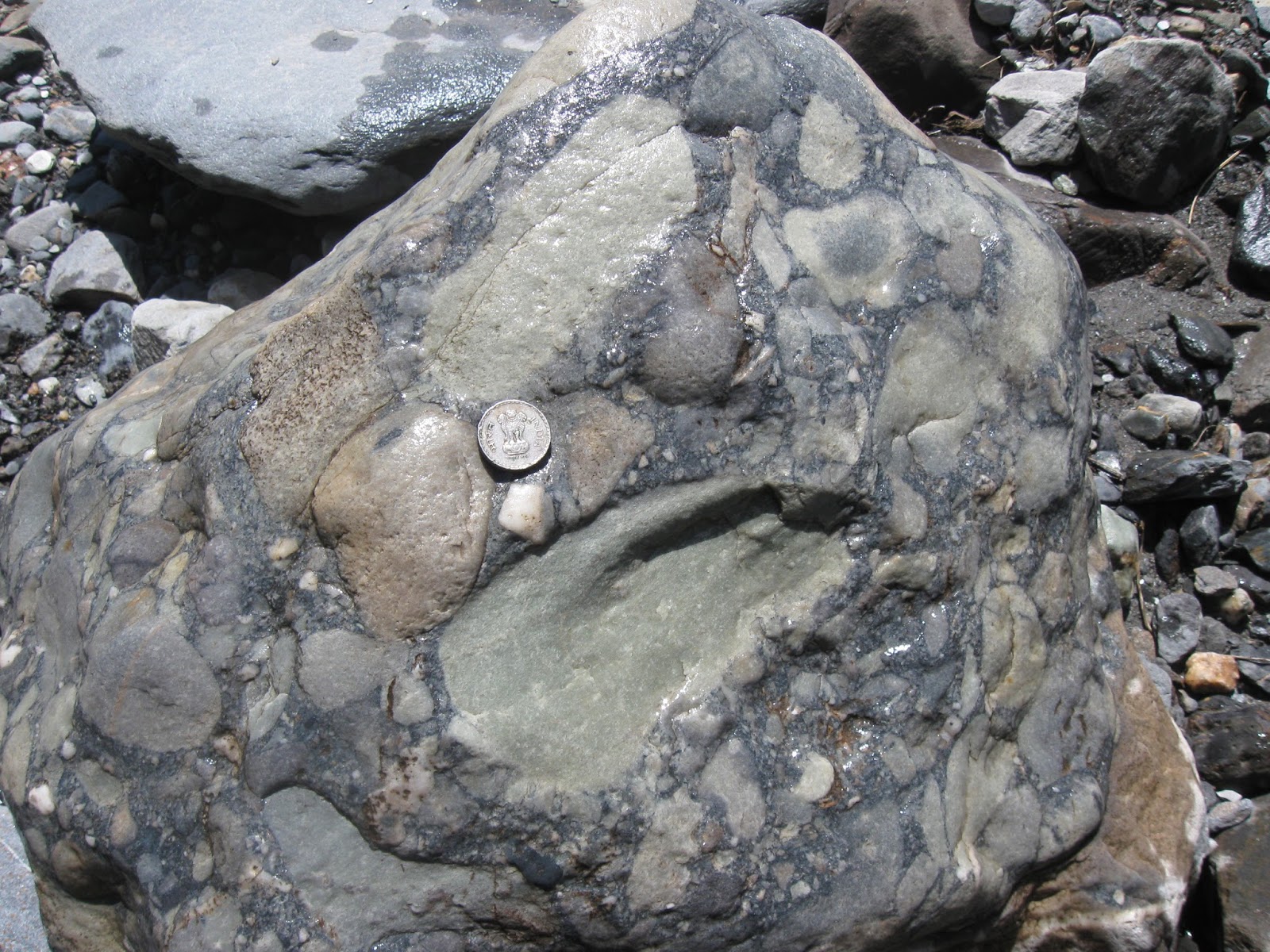
You will notice that the block is made up of a conglomerate (pebbly layer) in the lower part, overlain by a beautifully cross bedded sandstone towards the top. The ten rupee coin gives a sense of scale. The lower half of the block is a classic flat pebble conglomerate. You will realize the meaning of the term as you read along. A more detailed examination of the conglomerate hints at an unusual mode of formation. The clues lie in the four boxes I have drawn. I will focus on them one by one to make my case. This is the cross section of the pebbly layer. The bedding plane view is not exposed in the boulder.

Before that, let me put up this picture of another conglomerate. This sample too has rolled down from the high ridges near Dantu village.

Sedimentologists will be confident in interpreting this as deposition in a gravelly stream or in the surf zone of a beach. The smooth and rounded shape of the cobbles is due to long transport from the source to the site of deposition, followed by the particles rubbing against each other in a high energy current and wave environment. 

Now take a look at the pebbles in Box 1. 

They have straight and jagged sides and pointed edges. This indicates very little transport and attrition before burial. The source rock of these pebbles must have been near by.

In fact, the source can be observed in Box 2.

The dark grey elongated pebbles were derived by the breakage of the bed in the lower part of the block. The dark grey layer has a fragmented fabric.  I have outlined in yellow some larger blocks of the remnant bed. They are surrounded by smaller broken pieces. It looks like a layer which hardened quickly on the sea floor broke due to a disturbance and yielded these flat pebbles. These pebbles are called intraclasts, since they are derived from a source from within the depositional environment. The slab like shape of the pebbles suggests breakage along parallel planes of weakness. The breakage is not due to tectonic overprinting since the overlying cross bedded sandstone is not affected.

Complete disarticulation of an early cemented layer will ultimately yield individual centimeter scale pebbles which make up the pebbly layer highlighted in Box 3. 

Notice the mostly horizontal disposition of the pebbles suggesting transport in a viscous laminar flow and quick burial. The sandy matrix has prevented pebbles from bumping into each other, thus preserving their sharp faces and edges. In contrast, constant exposure to waves and currents would have resulted in the sand being winnowed out and caused these platy pebbles to be rounded, imbricated and stacked at an angle.

Fine quartz and lime mud sediment was cemented by calcium carbonate on the sea floor within a few tens of centimeters of burial. This semi lithified layer then broke during an earthquake or when the sea floor was pounded during a severe storm. 

 Box 4 captures this transition from an in-place unbroken layer which show signs of breakage towards the top. 

Slope failure and mass movement of such a layer eventually resulted in complete breakage of the rigid bed and the formation of discrete flat chips which then were deposited as a flat pebble conglomerate. Box 1 to Box 4 represent different stages of the deformation and sedimentation process. The sharp contact of the layer in Box 3 with the underlying layer (see pic of the entire block) suggests that it may be material transported from an adjacent area where an equivalent bed was completely disarticulated. 

Occurrence of slope failure induced flat pebble conglomerates have been previously observed and reported from the Cambrian age Snowy Range Formation in  northern Wyoming and southern Montanan, U.S.A.

I have observed only one example of this during my recent visit and I have proposed only a tentative answer. Without observing and understanding the stratigraphic and sedimentologic context in an outcrop I cannot be certain that it is correct. 

The association of undeformed and deformed blocks does suggest that intermittent disturbances resulting in brittle and ductile deformation of semi hardened sediment masses alternated with quieter periods of sedimentation. The overlying cross bedded sandstone is an example of deposition during quieter phases.

Flat pebble conglomerates mostly form in sedimentary carbonate environments. This make sense since rapid cementation of the sea floor by calcium carbonate saturated sea water is common. This example though is from a predominantly siliciclastic setting where quartz rich silt lithified fairly rapidly.

These conglomerates also show a peculiar temporal range. They are common in Proterozoic and Cambrian age sequences, but become exceedingly rare in younger rocks. Paleoecologists suggest that this is due to the diversification of burrowing animals that took place during the Great Ordovician Biodiversification Event about 485 to 460 million years ago. 

The churning of sediment by bioturbation kept the sediment loose and granular and prevented frequent cementation of the sea floor and shallow buried layers. Carbonate intraclasts became rarer, forming only in more geographically restricted harsh hypersaline settings. Flat pebble conglomerates give us a glimpse in to the ecology and physical properties of the sea floor before the evolutionary radiation of burrowing macrofauna.

Geological processes and evolution interact and feed off each other.  Through earth history, the formation of diverse topography and chemical environments by geological circumstance have been triggers for evolutionary innovation.  In this example, the evolution of animals making deep vertical burrows resulted in the disappearance from the geologic record of a distinctive sedimentary rock type. Yet, the churning and resulting oxygenation of the sedimentary profile opened up new ecologic spaces for the colonization and diversification of a more complex web of marine communities. 

My quest for a more complete answer to the origin of these deformed sandstone continues. 

Stream near Baun village

On my next trip to Boun I will try to find more of these blocks to gather evidence in support of my theory. Or, who knows, try to find an easier route towards those high ridges! Stay tuned.

Further Reading:

1) Rapid Uplift - Field Photos: Folds- Tectonic Or Soft Sediment Deformation?

2) Thematic Posts - Rapid Uplift- Geological Processes and Evolution.

Monday, February 17, 2025

20,000 Days In The Life Of A Clam

My Whatsapp profile description says, "what's a million years here and there".

It is a tongue in cheek acknowledgment of the vast spans of time geologists often have to contend with. If I am studying a rock that formed more than a billion years ago, a 5 to 10 million year uncertainty in nailing down its exact time of formation is acceptable. Uncertainty in estimating the time of formation may occur due to our as yet not so perfect understanding of the decay rate of various radioactive isotopes being used for dating, or due to limits of sensitivity of the instruments measuring the radioactive isotopes in the mineral. We are making great strides in measurement techniques with a 0.1 % accuracy now achievable. 

Sedimentary rocks are harder to date than igneous rocks since minerals with radioactive elements rarely form in them at the time of their deposition (some limestones and black shales are exceptions). Often, using some indirect methods we can bracket their maximum and minimum age. Take the example of the Alwar Group sedimentary rocks which occur in the northern Aravalli mountains in Rajasthan. They are estimated to have been deposited sometime between 2.1 billion years ago and 1.8 billion years ago, an uncertainty of 300 million years! We know from our understanding of sediment accumulation processes that deposition was not uniformly spread out over the 300 million years. Rather, the sequence of sediments would have been deposited in discrete pulses lasting 10 to 20 million years, separated by long phases of non-deposition. 

Amazingly, even though we don't know exactly when during the 300 million year interval these sediments came to be deposited, we can track fairly accurately what was happening then on a daily basis. Some strata of the Alwar Group are of shallow marine origin. As the daily tide flooded in and ebbed, a thin layer of sand was deposited during each of these high energy phases. During the slack phase in between, a thin layer of mud was deposited. Stacks of these tidal bundles made of a sand and mud couplet record the passage of daily tides. Observing the stacking pattern closely reveals even more details. Sets of bundles of thicker sand-mud couplets alternate with sets of thinner bundles. Each set formed during alternating spring (thick layers) and neep tide (thin layers) cycles. 


We can interpret the ancient record by comparing the patterns with those forming today in different settings. The principle "present is the key to the past" is used with some caution, but it works well in this case.

Such tidal rhythmites are fairly common in the geologic record. The pictures to the left is a section of a core from  Cretaceous age sediments laid down in an estuary. The sedimentary section is made up of sets of thicker silt layers capped by a darker mud layer, overlain by a set of thinner silt and mud couplets. Each silt layer represents deposition during the flood or ebb tide. During the slack period, stirred up organic rich mud settled down. Again, we don't know the exact age of the rock to a certainty of few hundred thousand years, but we can track daily events. Image source: G. Shanmugan; AAPG Bulletin v. 84, 2000.

Speaking of tides, the earth's rotation is slowing down due to tidal friction. Marine organisms like corals, brachiopods, and clams build a calcium carbonate skeleton to house their soft tissues. Their shell grows by a daily addition of a thin mineral layer. Geologists have studied the pattern of skeleton growth of Paleozoic corals. Besides daily growth bands, they can identify seasons too, as corals lay down thicker bands during the dry season and thinner bands during the wet phase. The number of days in the year are estimated by counting the number of daily bands in each season. It turns out that there were about 420 days in a year during the early and middle Silurian (between 443 million to 419 million years ago). By middle Devonian (roughly 370 million years ago), some 50 million years later, the number of days had reduced to about 410. Using bivalve shells, scientists estimate that there were 370 days in a year by Late Cretaceous times (about 80 to 70 million years ago). 

There are other examples closer to our own existence on earth of natural rhythms being preserved in rock. Geologists and climate experts routinely use mineral bands in cave stalagmites to understand variations in rainfall. A recent study by Gayatri Kathayat and colleagues from Uttarakhand, North India, reveals details of the course of Indian monsoons over thousands of years, mapping dry and wet phases lasting few centuries each. Despite an uncertainty of a few decades in the absolute age of each layer, it gives us a broad picture of climate change through the Holocene. 

We accept the fuzziness of our estimates of the age of an event while being able to sharply resolve the changes taking place in that cloud of uncertainty.

I could have named this post "Ode to Laminae", an appreciation of thin layers that form in tune with earth cycles and which preserve in their layering valuable information on ancient tides, earth moon dynamics, changing of seasons, and longer term climate change.  I just thought the title of the post and the paper it refers to is better click bait. 

Sometime in the Late Miocene (about 10 million years ago, what's a few tens of thousands of years here and there) a giant clam living on the western margin of the Makassar Strait (Indonesia) built a shell with daily growth increments. I will post the entire abstract of the paper below so you can get an idea of the details of ocean conditions scientists can tease out today with sophisticated instrumentation.  

 Iris Arndt et.al., 20,000 days in the life of a giant clam reveal late Miocene tropical climate variability.

Giant clams (Tridacna) are well-suited archives for studying past climates at (sub-)seasonal timescales, even in ‘deep-time’ due to their high preservation potential. They are fast growing (mm-cm/year), live several decades and build large aragonitic shells with seasonal to daily growth increments. Here we present a multi-proxy record of a late Miocene Tridacna that grew on the western margin of the Makassar Strait (Indonesia). By analysing daily elemental cycle lengths using our recently developed Python script Daydacna, we build an internal age model, which indicates that our record spans 20,916 ± 1220 days (2 SD), i.e. ∼57 ± 3 years. Our temporally resolved dataset of elemental ratios (El/Ca at sub-daily resolution) and stable oxygen and carbon isotopes (δ18O and δ13C at seasonal to weekly resolution) was complemented by dual clumped isotope measurements, which reveal that the shell grew in isotopic equilibrium with seawater. The corresponding Δ47 value yields a temperature of 27.9 ± 2.4 °C (2 SE) from which we calculate a mean oxygen isotopic composition of late Miocene tropical seawater of −0.43 ± 0.50 ‰. In our multi-decadal high temporal resolution records, we found multi-annual, seasonal and daily cycles as well as multi-day extreme weather events. We hypothesise that the multi-annual cycles (slightly above three years) might reflect global climate phenomena like ENSO, with the more clearly preserved yearly cycles indicating regional changes of water inflow into the reef, which together impact the local isotopic composition of water, temperature and nutrient availability. In addition, our chronology indicates that twice a year a rainy and cloudy season, presumably related to the passing of the ITCZ, affected light availability and primary productivity in the reef, reflected in decreased shell growth rates. Finally, we find irregularly occurring extreme weather events likely connected to heavy precipitation events that led to increased runoff, high turbidity, and possibly reduced temperatures in the reef.

Tell me geology isn't the coolest field of study.

Sunday, July 23, 2023

Septarian Concretion from Khambhat

My friend Bhushan Panse, who is a geology enthusiast and an avid rock and mineral collector, handed this specimen to me over a coffee meeting. He had bought it from a mineral supplier from Khambhat, Gujarat.

I commented that it is a septarian concretion. These hard ellipsoidal or oval shaped lumps form in mud and silt layers by the precipitation of calcite  around a nucleus. Khambhat and many other parts of Gujarat are underlain by Mesozoic and Cenozoic age sedimentary rocks. The process of concretion formation would have taken place at shallow burial depths when these sediments were still porous and water saturated. Mineral deposition in pore spaces often takes place in concentric layers. The calcium carbonate comes from saturated marine pore water or is derived from shells as they start dissolving during shallow burial. Notice the rust to brown color of the concretion. It is likely due to the presence of iron oxide and hydroxides which formed in the pore spaces from the iron contained in clay minerals.

The term Septarian Concretion refers to the radiating cracks or Septaria (derived from Septum). Cracks come in a variety of shapes. There are radiating cracks as seen in this specimen. These cracks are wider near the center and taper outwards. Other concretions may show concentrically oriented cracks, or overlapping sigmoidal shapes. Cracks may intersect, pointing to multiple cracking events. They are filled with either calcite or silica. The crystals filling these cracks are sometimes broken and displaced, and cracks may contain mud and silt. These features indicate a variety of stresses at play in concretions interiors. 

There are many ideas on how these cracks form. They have been interpreted as shrinkage cracks due to desiccation and hardening of mud. Dehydration during chemical transformation of clay minerals is another explanation.  A third hypothesis links the formation of cracks to gas expansion released during putrefaction of organic material. 

Sedimentologist Brian Pratt has offered another novel explanation. He proposed that these cracks result due to shaking of sediment during synsedimentary earthquakes. Shaking during ground motion results in variable stress fields in the interior of the concretion forming a large variety of crack geometries. These concretions may be preserving signals of  seismicity affecting that sedimentary basin!

Here is his compilation of the large variation in septarian concretion cracks from various sedimentary basins across Canada.


 Source: B. Pratt: Septarian concretions: internal cracking caused by synsedimentary earthquakes

A geologist friend who worked with the Geological Survey of India suggested another intriguing explanation. Parts of the region near Khambhat experienced explosive volcanic activity towards the waning phases of Deccan Volcanism. Ash expelled from volcanoes can coat small broken lava fragments forming lumps known as  'áccretionary lapilli'. Aggregations of ash and pyroclastic material if larger than 64 mm are known as volcanic bombs. This concretion fits the size range of a bomb. The dark fragments in the center of the concretion do resemble a fine grained igneous rock. A closer examination under a microscope is needed for a confirmation of its origin.

It is fun to examine hand specimens that friends collect from various part of the world and try to identify the rocks and minerals. But often a clear cut answer is not possible due to the need for additional information from a higher resolution or the chemical makeup. But a guessing game over coffee is always welcome. 

Geodes, nodules, and concretions found in volcanic and sedimentary rocks are mystery objects. You never know what you will see inside when you break open one of these lumps. There may be an array of perfectly faceted purple amethyst crystals and multicolored calcite. Or a trapped fossil. Or a crack network filled with bright and shiny calcite and quartz. These crystal rich interiors give us important information on the composition of fluids which react with rock at many different times during their geologic history. This water rock interaction is of interest to mineralogists and  economic geologists who want to understand the history of fluid flow through sedimentary basins and the conditions that lead to the concentration and deposition of metals. 

Geological investigation at all scales inform us about how the earth works. One can stand and gape at great mountain ranges and wonder about the movement of tectonic plates. But you can also crack open a rather dull colored lump from a shale and marvel at its insides, all telling a story of groundwater flow and chemical reactions, and who knows, past earthquakes as well. 

Monday, August 16, 2021

Readings: Mars Geology, Human Diversity, India Rock Art

 A few interesting readings:

1) NASA's Mars Perseverence Rover is hard at work. It has an amazing collection of geochemical instruments which are probing the surface with the aim of categorizing the mineralogy and chemistry of surface materials. The hope is to pinpoint regions which could have hosted microbial life.

Signs of Life on Mars: NASA's Perseverance Rover Begins the Hunt 

2) How are Andaman Islanders closer to Swedes than to Africans?

Razib Khan explain in this informative essay on patterns of human diversity and what it tells us about human migrations and population admixture over the past 100,000 years.

Out of Africa's midlife crisis-on bottlenecks, crashes and what diversity really looks like: How are Andaman Islanders closer to Swedes than to Africans?

3) On the Aravalli ranges quartzite rock faces in the state of Haryana is art created as long as 20,000 years ago. The locals always knew about it, but the Archeological Survey has just begun studying it in detail. 28 ancient sites have been found. I hope all of them get protection immediately. Smithsonian Magazine has a summary describing these finds. The final photo of rock art in the article depicts mounted warriors. Are they mounted on donkeys/mules or horses? Curious to know what readers think. I am leaning towards them being donkeys or mules.

These Millennia-Old Cave Paintings May Be Among India’s Oldest. 

Monday, June 7, 2021

Liesegang Banding In Proterozoic Badami Sandstone

The Chalukya era (6th-8th CE) rock cut caves and sculptures at Badami in Karnataka are an archeological wonder. But there is plenty of geology there to admire. In January 2020, I spent some time wandering through Badami. The sandstone layers are 900 million years old river deposits. I wrote a long post about them, explaining the primary sedimentary structures that one can observe in these rocks, and what they tell us about the water depths and currents during deposition of the sediment. 

But these primary structures, i.e. sedimentary layer orientations that form during deposition, are not the only interesting features of these rocks. Chemical reactions in these sediments after their burial has overprinted an intriguing fabric on to the rock.

In the picture a very distinct dark and light banding is seen in one of the Badami rock surfaces. This is Liesegang banding. 

The dark bands are rich in iron oxide. The lighter bands have little or no iron oxide. Such banding forms by the mobilization of ions from one location in the sediment and their precipitation at another. Ions diffuse along a concentration gradient in the water filled pore spaces. Robert A. Berner's book, Early Diagenesis: A Theoretical Approach, has a good explanation for the formation of Liesegang banding. I am reproducing that below.

"Mobilization of different components of a substance can occur at two or more different locations. The best example of this is the formation of Liesegang banding.In Liesegang banding we have the interdiffusion of two dissolved ions which cab react with one another to form a relatively insoluble solid. The two ions can come from different sources and when their concentrations at a given site build  up, via diffusion, to sufficiently high values, precipitation of the insoluble solid occurs. This precipitation suddenly lowers concentration in the neighborhood of the solid, and as a result the diffusion profiles become altered. Continued interdiffusion results in a new build-up in concentration and precipitation at another site. Depending on the geometry of the situation, this process may result in Liesegang rings (3-dimensional), tubes (2-dimensional), or layers (1-dimensional). A common example of Liesegang phenomenoa are rhythmic bands of iron oxides often found in sandstones. In this case precipitation is most likely brought about by the interdiffusion of dissolved Fe++ (from an anoxic) source) and dissolved O2 (from an oxic source). Where the Fe++ and O2 meet, Liesegang banding occurs".

The iron (Fe++) would already have been present in the sediment perhaps in discrete grains of pyrite (FeS2), or trapped in carbonaceous plant debris.   Rainfall fed groundwater is the common source of oxygen.  As pyrite gets oxidized it releases Fe++ and sulphur ions. The ferrous ions get oxidized to ferric ions (Fe+++). These then nucleate to form iron oxide or hydroxides. Rapid diffusion of ions towards a growing crystal will eventually lower the concentration of ferric ions in the region surrounding the grain to below the nucleation threshold, at which point crystal growth stops. This threshold is reached at a different location where pyrite oxidation is releasing a fresh supply of Fe++. At this new location the concentration of ferric ions build up again to levels where they start nucleating into iron oxide. This migration of zones of dissolution (of pyrite) , diffusion, and nucleation results in the distinct banding. I've summarized this explanation from a paper by P. Ortoleva and colleagues on redox (reduction-oxidation) front propagation and formation of mineral banding.

Formation of redox fronts during the burial of a sedimentary rock can be economically important. For example, a certain type of sandstone hosted uranium deposit known as 'roll-front' occur where oxidizing fluids containing dissolved uranium meet reduced components such as pyrite or organic matter. 

Here is another close up of these Liesegang bands. They have a ring or a tube like geometry. The cross bedding indicated by the arrow is a primary structure formed by the movement of sand sculpted into ripples or waves on the river bed. The Liesegang bands have been imprinted over the cross beds subsequently. 

The chemical reactions that occur in sediment after their deposition are of great interest to geologists.  They play a large role in the reorganization of porosity and permeability through the dissolution and re-precipitation of minerals.Throughout the history of a sedimentary basin, fluids move through these pore networks mobilizing elements, and under favorable conditions, enriching them at particular locations. Geologists prospecting for metal and hydrocarbon deposits want to understand this process.


Sunday, June 17, 2018

Mars Geology

Came across a couple of cracking papers on Mars geology

1) Ancient Martian aeolian processes and palaeomorphology reconstructed from the Stimson formation on the lower slope of Aeolis Mons, Gale crater, Mars - Steven G. Banham et. al. 2017

During its travels, the Mars Curiosity Rover has been taking some exquisite pictures of landscapes and rock outcrops. This study uses field photos of a sandstone body and analyses its ancient depositional setting.  The sandstone is a dune field, created and shaped by aeolian processes. The overall aim is to better understand the sedimentary environments on Mars, how they changed over time, and whether they could have been habitable environments.

Just take a look at the spectacular cross bedding and bed sets of the dune.


Source: Steven G. Banham et. al. 2017

And here is a depiction of the regional setting of the dune field


Source: Steven G. Banham et. al. 2017

2) A Field Guide To Finding Life On Mars- S. McMohan et. al. 2018

Excerpt: This paper reviews the rocks and minerals on Mars that could potentially host fossils or other signs of ancient life preserved since Mars was warmer and wetter billions of years ago. We apply recent results from the study of Earth’s fossil record and fossilization processes, and from the geological exploration of Mars by rovers and orbiters, in order to select the most favoured targets for astrobiological missions to Mars. We conclude that mudstones rich in silica and iron-bearing clays currently offer the best hope of finding fossils on Mars and should be prioritized, but that several other options warrant further research. We also recommend further experimental work on how fossilization processes operate under conditions analogous to early Mars.

I got to relearn a good bit about how depositional settings, mineralogy and geochemistry influence organic matter preservation.

Both Open Access.

Saturday, April 21, 2018

Everest Summit Limestone

Most people I talk to about geology are aware that the Himalaya formed by the buckling and uplift of crust caught up in the India-Asia collision. But, I do see eyebrows raised when I tell them that the summits of some of the highest peaks are made up of marine sedimentary rocks.

The summit of Mount Everest is a fossil bearing limestone of Ordovician age. These deposits are part of a thick pile of sediments of Cambrian to Eocene age which accumulated on the continental shelf of India. They suffered only shallow burial (up to ~10  km) preceding and during continental collision. They are known formally as the Tethyan Sedimentary Sequence.

What happened to these sediments as they got caught up in Himalayan mountain building? A recent study published in Lithosphere has teased out the deformation and metamorphic history of this limestone.

Polyphase deformation, dynamic metamorphism, and metasomatism of Mount Everest’s summit limestone, east central Himalaya, Nepal/Tibet - Travis L. Corthouts, David R. Lageson, and Colin A. Shaw

These scientists trained Nepalese Sherpa climbers to recover samples from the Everest summit. The location of the samples and the basic geological divisions of the summit is seen in the annotated photograph posted below


 Source: Travis L. Corthouts, David R. Lageson, and Colin A. Shaw 2018

The Everest region is made up of high grade metamorphic rocks of the Greater Himalayan Sequence. They are rocks of the Indian continental shelf of Late Proterozoic (~1000 million years old) to Ordovician (450 million years old) age which were buried to greater depths (up to 20-25 km) during continental collision. These rocks are intruded by leucogranite ( a light colored granite) dikes and sills.

Towards the upper levels, the grade of metamorphism decreases gradationally to upper greenschist facies. The contact between the two metamorphic grades is a shear zone termed the Lhotse Shear Zone. The greenschist faces rocks are termed the Everest Series.  On top of the Everest Series is the 'Yellow Band'. This is a coarse grained marble and calc-schist. The summit limestones (Qomolangma Formation) rests on this Yellow Band. The boundary between them is a fault zone known as the Qomolangma detachment. This fault zone is a strand of the South Tibetan Detachment (STD) that puts the Tethyan Sedimentary Sequence (TSS) on top of the Greater Himalaya Sequence throughout the extent of the Himalaya.

A schematic cross section depicting this stratigraphy is shown below.


Source: Travis L. Corthouts, David R. Lageson, and Colin A. Shaw 2018

Researchers used three types of analysis to figure out the geologic history of the limestone.

a) Microfabric analysis of the samples gave the geologists clues to the deformation and stress regime experienced by the summit limestone. The limestones have been converted into a mylonite. This means that increased temperatures and pressures from faulting resulted in a new textural arrangement in which the original calcite grains of the limestone were recrystallized and deformed. New calcite crystals grew flattened and stretched along one direction, resulting in a foliated (layered) streaky appearance to the rock. This texture forms during ductile deformation in a compressive stress regime. Geologists found that near the vicinity of the Qomolangma fault, a set of dilational fractures indicating extensional forces cut across these ductile deformation textures. This indicates that the summit limestone was subjected to tensile forces and normal faulting at a later stage.

b) Titanium content of quartz and biotite from samples close to the South Summit (EV6) indicated the temperature of metamorphism. This is so because the amount of Ti incorporated in to growing crystals of quartz and biotite increases with increase in temperature of crystallization. Results indicated that the limestones at the base of the Qomolangma Formation experienced temperatures as high as 500 deg C. 

c) The age of metamorphism was estimated by dating muscovite crystals using Ar40/Ar39 technique. Muscovite crystals grew in response to the increased temperature and pressure the limestone was subjected to during Himalayan orogeny. Dates show that there were two phases of mineral growth. The first at 28 million years ago, and a younger phase at about 18 million years ago, indicating separate events of movement and heating along the Qomolangma fault zone.

The leucogranite sills and dikes, which intrude the underlying Greater Himalaya Sequence, also merit a mention. They formed by the partial melting of the crust during Himalaya orogeny.  As this magma intruded and solidified inside the Greater Himalaya Sequence, they expelled fluids with volatile elements which permeated into the overlying limestone. This caused metasomatism and crystallization of secondary minerals in the limestone. Boron, potassium, titanium and H2O were introduced into the limestone and were incorporated into minerals like muscovite, biotite and quartz. This activity is dated to about 28 million years ago based on the age of secondary muscovite in the lower parts of the summit limestone.

The sequence of geologic events is summarized in the graphic below:


Source: Travis L. Corthouts, David R. Lageson, and Colin A. Shaw 2018

And an excerpt of the conclusions from the paper-

The different fabrics and metamorphic temperatures observed between the upper and lower parts of the Qomolangma Formation are the result of distinct events that influenced the summit limestone at different times throughout Himalayan orogenesis. Fabrics seen in summit samples are the result of Eohimalayan deformation and low-grade metamorphism associated with initial thrust faulting, folding, and crustal thickening of the Tethyan Sedimentary Sequence in the Eocene. In contrast, the fabrics and elevated temperatures preserved in South Summit samples are the result of events that occurred in the late Oligocene and early Miocene, including metasomatism associated with Neohimalayan metamorphism and normal faulting on the South Tibetan detachment. This means that several significant tectonic events in Himalayan orogenesis are preserved in the Qomolangma Formation, a succession of deformed Ordovician limestone that now comprises the top of Mount Everest.

Open Access.

Thursday, May 25, 2017

Chasing The South Tibetan Detachment- Panchachuli Glacier Area Kumaon Himalaya

This is a geology travelogue of my recent trek to the Panchachuli Glacier. This is the famous Darma Valley trek in the Dhauliganga river valley of the Kumaon Himalaya. For years, the trek began at village Sobla, about an hours drive north of Dharchula. From Sobla, it is a two to three day hike to Dugtu, which is the base village to approach the Panchachuli Glacier. However, when we went there in the first week of May 2017, a serviceable road had reached village Nagling. This cut two days of our walk. We began our trek at Nagling. It was a days walk to Dugtu. There I got a chance to look at the geology and especially search for an important fault zone I had been wanting to see. I begin this post with some geology background and then write about my observations during our walks around Dugtu.

The South Tibetan Detachment System (STDS) is an important fault zone in the Himalaya, bringing in to structural contact the Tethyan Sedimentary Sequence (TSS) with the underlying metamorphic rocks of the Greater Himalayan Sequence (GHS). It is a northerly dipping extensional or normal fault. This means that the Tethyan sediments which make up the hanging wall of the fault have moved down relative to the footwall made up of the Greater Himalayan Sequence. As the name suggests the STDS is most prominently developed in the southerly Tibet plateau like physiographic province of the Himalaya, north of the great Himalayan summits.

What is the history of the TSS and the STDS? As is the case with Peninsular India,  the northern extent of the Indian plate would have been made up of Archean granite and granite-gneiss terrains representing the earliest stable crust and greenstone belts (metamorphosed and deformed volcano-sedimentary rocks). On this Archean-lowermost Proterozoic foundation were deposited successions of sedimentary packages, some intruded by igneous rocks. These range in age from the Mesoproterozoic to the Eocene.  The Archean and lowermost Proterozoic rocks are not exposed anywhere in the Himalaya. The Lesser Himalaya Sequence and the Greater Himalaya Sequence are slices of crust containing the Mesoproterozoic to Phanerozoic successions which have been metamorphosed to varying degrees during Himalayan orogeny. The Tethyan Sedimentary Sequence represents late Neoproterozoic to Eocene successions which largely escaped metamorphism during Himalayan orogeny.

In the early Cenozoic, when the Indian plate impinged into Asia this Neoproterozoic to Eocene sedimentary "cover" was folded, faulted and scraped off to form an early "Tethyan" mountain range. As collision continued and as lower tiers of the Indian crust subducted under Asia, thrust faults moved slices of deeply buried and metamorphosed crust upwards. These slices are the Greater Himalayan Sequence. They are bounded by the Main Central Thrust at its base and by the STDS at the top. Concurrent with the movement of the Main Central Thrust, fault zones developed at the base of   the Tethyan sedimentary cover, perhaps along the same planes of breakages that had earlier uplifted the Tethyan ranges. This fault zone evolved into the STDS.

There are different hypothesis on how important the STDS is to the evolution of the Himalayan orogen. One school of thought suggests that the extention and thinning of the crust along the detachment zone accelerated the exhumation of the deeply buried GHS and brought these deeper levels of the crust in to structural contact with the Tethyan cover sequence. Alternative scenarios argue that thrust faulting played a more prominent role in the southward propagation and exhumation of the GHS with the STDS playing only a minor role in the exhumation of the footwall GHS.

Whichever scenario is correct, there is no doubt that the South Tibetan Detachment is a major structural boundary separating two distinct lithologic terrains.

The outcrops around me during my trek where all metamorphic rocks of the Greater Himalayan Sequence. I had hypothesized that the South Tibetan Detachment and Tethyan rocks if they indeed were present in the area would be making up the summits of the ranges around Dugtu and in the Tidang area.

After days of observation I was proved right about that. I used three types of indicators to infer the  presence of Tethyan sedimentary rocks high up on the summits and to recognize the fault boundary between them and the underlying Greater Himalayan Sequence metamorphic rocks.

1) Structural discordance between the Greater Himalayan Sequence and the Tethyan Sedimentary Sequence. This could be clearly seen near the summits of the ranges north and east of Dugtu.

2) Boulders of sedimentary rocks like conglomerate and planar and cross bedded sandstones in the streams draining these ranges.

3) Dilation fractures in both the phyllite grade metamorphic rocks of the Greater Himalayan Sequence and in sandstones of the Tethyan Sedimentary Sequence. This indicated the presence of an extensional stress regime. The South Tibetan Detachment is a zone of normal faulting. The crust has been broken and pulled apart by tensional forces. These stresses were felt over a broad zone and impacted the footwall and hanging wall rocks.

As I am writing up these three criteria I have to admit that my thinking about these lines of evidence was not at all clear when I started the trek. Rather, my ideas and understanding of the local geology evolved haphazardly over the days as I walked the valley and started noticing structural orientations, stream rubble and fracture patterns.

We began our trek at Nagling village. Our destination was the village of Dugtu (Lat 30.2486, Long 80.5460). We walked northwards. As Himalayan thrust sheets dip north, we were going structurally higher and higher up the Greater Himalayan Sequence. At, and ahead of Nagling, we were in a zone of partial melting and granite intrusions. High grade gneiss and migmatites were intruded by dykes and sills of granite. I'll be posting about this section separately. This high grade gneiss zone was overlain by a sequence of phyllite grade metamorphic rocks. These phyllites show tight isoclinal and recumbent folding. The internal structure of the Greater Himalayan Sequence is interesting. There is an increase in metamorphic grade from the base to the higher levels and then a decrease towards the very top.

Above the phyllite grade rocks separated by the STDS are the Tethyan sediments. I figured I would have traveled north enough, i.e. structurally high enough along the GHS to cross the phyllite zone and into the overlying Tethyans. I had an expectation that at the very least I would notice them capping some of the ranges I was going to encounter between the villages of Dugtu and northward towards Sipu.

Here is an interactive map of the area I trekked, which you can use to follow the text and check on the locations of the samples.


Day1 - The northerly walk takes a left turn as we enter the Panchachuli Glacier valley. The river Dhauliganga is a west to east flowing river in this valley near Dugtu village. We entered the village of Dugtu in pouring rain. Every mountain range was covered in clouds, and in any case the rain was heavy enough to keep us indoors for the evening.

Day 2- More rain! It happened during my last trek in the Munsiari valley too. We go stuck there for two days due to heavy rain and snow. As it happened, the rain stopped by afternoon and we could go for a short walk to the twin village of Dantu across the Dhauliganga river. The river bed was chocked with boulders of a distinct biotite-tourmaline bearing granite (Picture to the right). Both Dugtu and Dantu villages are located in phyllite grade rocks. This conspicuous granite does not intrude these rocks. Its source lies in the Panchachuli ranges, lower in the GHS. The Panchachuli Glacier has gouged it from the Panchachuli ranges and transported the debris to this valley. All the summits were still covered by clouds and I was resigned to wait it out for any further observations of the geology.

Day 3- Perfect weather. It was bright and sunny. But I hardly did any geology this day. We took a spectacular 5 kilometer walk westwards to the Panchachuli glacier.  The terrain was covered by forest, shrubs and grass and higher up by ice. We walked along the lateral moraines of glaciers past. The Panchachuli glacier was much bigger during the Pleistocene ice ages and glacial deposits are piled up high in the valley. I'll be posting on these deposits too. If only I had just glanced to the east of Dugtu and looked carefully at the ice snow covered ranges!!

Day 4- Great weather again! We took a northerly course towards the village of Tidang. Our original plan was to walk up further north to the village of Sipu. However,  the ITBP (Indo-Tibetan Border Police) were restricting movements of civilians in that area and we got a nod to go only to Tidang on a day trip. This is fantastic terrain. We passed through pine forests and then into a landscape of open woodlands and scrublands. We were now in the Lassar Yankti valley. The picture below shows a north facing view of the Lassar Yankti valley.


 This river joins the Dhauliganga near the village of Dugtu. There were enormous mountain ranges on both sides of the valley. Here below is a view of the mountain ranges on the right bank of the Lassar Yankti near the village of Dakad.  The north dipping rock faces in the foreground are Greater Himalayan Sequence phyllites. I had a feeling that if there were Tethyan sediments here they would be making up the summits of the range in the background.   I was keeping my eyes peeled for anything interesting.


And soon I began noticing that phyllite grade rock fragments scattered along scree slopes showed dilation fractures (Pic to the left). These fractures occur when the crust is being subjected to tensile forces. I now strongly suspected that these upper structural levels of the GHS were close enough to the STDS to have experienced extensional stresses. The picture show a phyllite grade rock with foliation displaced along a fault (black line) and showing dilation fractures (above) and another phyllite with parallel sets of dilational fractures (below). The fractures have been filled or healed with secondary quartz.

We passed the village of Dakad (Lat 30.2756, Long 80.5291). A few hundred meters ahead I had the first of the big "aa-haa" moments of the trek. A large boulder of sandstone showing planar and cross bedding lay just a few meters aside of the trail. It must have been transported there either during a rock fall or by glaciers from high up on the ranges on the right bank of the Lassar Yankti. A few minutes ahead we came across a stream draining these ranges and joining the Lassar Yankti. In that stream near the bridge connecting to village Tidang I saw a conglomerate boulder (Lat 30.2822,  Long 80.5262). Sedimentary rocks of the TSS were definitely present high up in that range. Here is a picture of the cross bedded sandstone (above) and the conglomerate (below).


Looking up towards the ranges, I could not identify a lithologic or structural boundary, but the presence of dilation fractures and sedimentary debris pointed to the presence of the STDS and the TSS high in those ranges.

Day 5- The weather Gods were kind again. We trekked westwards from Dugtu along the left bank of the Dhauliganga river towards the terminal moraine of the Panchachuli glacier. The rock walls on the left bank of the river were phyllite grade rocks. Again, I found dilation fractures in them. And in a small stream draining those ranges... another conglomerate (Pic to the right) ! (Lat 30.2471, Long 80.5181). I looked up to the summits carefully. Perhaps my viewing angle was just right or perhaps my mind was now better prepared but... there it was... a clear structural discordance between steep northwesterly-dipping rocks and the overlying more gently northeasterly-dipping rocks. I was looking at the South Tibetan Detachment Fault that had placed Tethyan sediments over the Greater Himalayan Sequence (picture below; join the tips of the arrows to trace the detachment fault).


I then looked through the valley straight towards the ranges to the east of Dugtu. Again, that same structural discordance was clearly visible in the snow capped summits. The picture below (photo credit: Swati Pednekar )  shows this eastern range, the detachment fault (join the tips of the arrows to trace the fault) and the lithologic units.


Day 6- A trek to villages of Goe, Philam and Bon. We walked north from Duktu, crossed the Lassar Yankti river a little ahead of Dantu village and entered village Goe (Lat 30.2602, Long 80.5411) and then walked southwards. That morning I had confidently predicted that we would find sedimentary rock with dilation fractures on this trail. These villages are at the base of the ranges shown in the picture above. Although not diagnostic, there was another strong hint that these ranges had sedimentary rocks at the summits. The summit rocks have weathered into a blocky square edged pattern typical of jointed sandstones and quartzites.

And I was right! Sandstones along with low grade phyllite rocks (from the lower levels of the mountain) were being used to build walls and pavements in all the three villages. Picture on the left (above) shows a cross bedded sandstone block making up part of a wall in village Goe. And a cross bedded sandstone slab (left, below) is being used as a pavement stone for a village trail between Goe and Philam. Further south ahead of village Bon, a large stream draining these mountains contained boulders of bedded sandstones. And at a small bridge at the bottom of the valley  (Lat 30.2370, Long 80.5450) I came across a sandstone block (picture below) with slickensides (black arrows) and dilation fractures (red arrows). Slickensides are striations on rock surfaces formed by frictional movement of rocks along a fault. This was a strong indicator that these sandstones were sourced from an extentional fault zone high up near the summit.


We continued walking southwards, into lower levels of the GHS. Soon, we were back in the Nagling area, in the zone of partial melting and granite intrusions.

This ended our trek in the Panchachuli Glacier area. To date, it was the most satisfying trek I had done in the Himalaya. Although the STDS was high up and I could not actually walk across it, I had hypothesized, made observations and validated my expectations of the presence of the detachment faults and Tethyan sedimentary rocks. This would be a good field exercise for students! And I am hoping this post will be used by trekkers wanting to explore and understand the geology of this area.

Day 7- We trekked to the Nagling Glacier which has carved a perfect U shaped valley. Certainly one of the most beautiful sites I have been to.


... more geology posts on glacial deposits and granite intrusions... coming soon.. !

Tuesday, October 25, 2016

Photomicrograph: Super Mature Quartz Arenites From Proterozoic Cuddapah Basin

One of the vivid memories of my Master thesis fieldwork in South India were a series of brightly reflecting hills. In the afternoons, the bare slopes of the hills were a blinding white and you had to wear dark sun glasses to minimize the glare.

These hills were made up of the Paniam Quartzite. This sedimentary sequence is part of the Neoproterozoic Kurnool Group which represents one megacycle of deposition in the long lasting Paleoproterozoic to Neoproterozoic Cuddapah Basin.  In sedimentary petrology terminology these white and bright sediments are quartz arenites, rocks made up mostly of the mineral quartz. In fact, they were super mature quartz arenites, i.e. they were made up of more than 90% quartz. I  point counted several samples and the percentage of quartz was around the 95%-96% mark.

Here is what they look like under the microscope. Notice how rounded the quartz grains are.


The white arrows in the photomicrograph below points to quartz cement which has precipitated between the grains. These cements are called overgrowths. They maintain the same optical orientation as the substrate quartz grain and hence in cross polarized light the detrital grain and the overgrowth appears as a single crystal unit. The detrital quartz grain is outlined by iron oxide dust which helps demarcate the contact between the grain and the later cement.


Here is another example of a super mature quartz arenite. The contact between the detrital grain and cement is again marked by a coat of dust. Notice the planar crystal facets of the quartz cement (white arrow) which contrasts nicely with the rounded detrital particles.

 
The example I have presented show only one generation of quartz overgrowth cement. There are instances where two generations of quartz overgrowth cements are present. Like the detrital grain, the first generation overgrowth has a coating of iron oxide or clay and is abraded. This indicates that the quartz grains have been derived from the erosion of older silica cemented sandstones. The original source of the quartz in these older sandstones were igneous or metamorphic rocks. After being eroded from these rocks and then transported and deposited, the quartz grains were overlain by silica cement (the first generation cement) and lithified into a sandstone.

Later (perhaps tens of millions of years later), this sandstone was uplifted and eroded. Disaggregation of grains during weathering broke of quartz sand particles along with attached fragments of cement. This cement overgrowth then got abraded and rounded during transport and acquired a dust coat. In its final site of deposition it was overlain by new silica overgrowth (the second generation cement). Abhijit Basu and colleagues present an interesting example of such "second cycle" or "recycled" quartz arenites from the sedimentary sequences of the Bastar Craton from Eastern India (Image to left: source Basu et al 2013).

A careful examination of quartz arenites and generations of silica cements can reveal a lot of useful information about uplift, erosion and recycling history of the earth's crust.

Quartz arenites are not restricted to the Proterozoic. They are common in younger age Paleozoic, Mesozoic and Cenozoic deposits too. They occur only sporadically in Archean age deposits. Thick sequences of quartz arenites become more common in the Proterozoic. This increase in the occurrence of quartz arenites in the Proterozoic has to do with the changing tectonics of the earth.

Among the common rock forming minerals, quartz is relatively chemically inert and is more resistant to physical breakdown during weathering and transport. In the Archean, sedimentary basins were generally linear troughs formed in front of island arcs. Due to these tectonically active conditions, the basin floor subsided quickly and detritus derived from weathering of igneous and metamorphic source rocks was deposited and buried before physical attrition and chemical dissolution could remove unstable minerals. The result was a mineralogically "immature" sandstone with the framework of the rock made  up of  quartz, feldpsars and volcanic and metamorphic rock fragments in different proportions . The sediments and associated volcanic material frequently got metamorphosed to a low grade "green mineral" assemblage of chlorite, actinolite and epidote. These deformed and metamorphosed successions embedded in Archean gneiss terrains are known as greenstone belts.

There are a few instances of quartz arenites in the Archean from terrains of the Canadian Province, the Baltic Shield in Russia and from the Bababudhan Group of the Dharwar Greenstone belt in South India. Many of these have been interpreted as a product of intense chemical weathering in Archean soils, wherein unstable pyroxenes, feldspars and meta-igneous and meta-sedimentary rock fragments were leached away, leaving behind a quartz rich residue. Sedimentary structures like cross bedding and ripple marks indicate shallow water environments of deposition where the sand was further subjected to physical attrition leaving behind a quartz rich sand deposit.

Such conditions of longer residence time and more intense chemical weathering in soil profiles and long periods of attrition and physical sorting by wave and tidal action became more common in basins of Proterozoic age. Phases of prolonged magmatism and heat loss from around 3 billion years ago to 2 billion years ago resulted in a cooler earth and one that now was made up of large rafts of granite/granodiorite crust which was buoyant and tectonically stable. Although the boundary between the Archean and the Proterozoic is pegged at around 2.5 billion  years ago, basin tectonic styles do not change abruptly. These were evolving conditions.

In Peninsular India, Proterozoic age sediments were deposited in two types of basins manifesting different tectonic styles. "Mobile Belts" are reminiscent of the older Archean greenstone belts in that they were tectonically active elements of the crust, perhaps forming in subducting settings at the boundary between two cratonic blocks. They are depressions which contain abundant volcano-sedimentary successions made up of volcanic flow and ash beds interlayered with  immature sand and mud and chemically precipitated silica and iron oxide layers.  These are interpreted as deeper water deposits. Some basins contain stromatolite limestone/dolomite. There are a few quartzite deposits too.  These may be the metamorphosed equivalents of quartz arenites which were deposited in shallow water environments.  These successions were subjected to metamorphism, deformation and intrusion by granitic plutons during orogenic episodes forming the "mobile belts" or fold belts.  The Aravalli and Delhi Group of sediments which make up the Aravalli mountain ranges in Rajasthan are a good example of these Early to Mid Proterozoic mobile belts.

Overlapping in time with the mobile belts but extending into the Neoproterozoic are the epicratonic basins, also known as the "Purana" basins. These basins experienced less volcanic activity and were subjected to less deformation and metamorphism than that seen in the mobile belts. They contain thick sequences of quartz arenites and limestones.  These basins were initiated by extension and rifting of the continental crust resulting in extensive shallow marine shelf areas.  Low relief Archean to Early Proterozoic source terrains made up of granitic and metamorphic rocks were subjected to intense chemical weathering. Since the basin floor subsided slowly in these passive margin basins, shallow water conditions prevailed for long periods of time. Quartz rich residues were transported and deposited as sand sheets in beach and tidal flat settings and as sand shoals in more open waters away from the shorelines. Wave action further sorted them into a texturally mature sand.

The Paniam Quartzite, whose afternoon glare I tried in vain to avoid, is a remnant of one of these vast sand sheets that occur across many epicratonic Proterozoic basins in Peninsular India. Other examples of this stable cratonic style of deposition include the Vindhyan Basin in Central India and the Kaladgi and Bhima Basins of South India.

The satellite image below shows the brightly reflecting slopes (white arrows) of this quartz arenite deposit around the village of Gani in Andhra Pradesh. The black dotted line is the contact between the Archean basement and the overlying Proterozoic Cuddapah Basin sediments. The linear structure is the left lateral Gani Kalava fault offsetting the Cuddapah Basin.


And here is one final photomicrograph of the Paniam quartz arenite showing well rounded detrital grains with faceted quartz overgrowths meeting in planar contact in the pore spaces.