Showing posts with label metamorphic rocks. Show all posts

Saturday, January 11, 2025

Shear Luck Near Sunderdunga River

As I settled down for lunch by the Sunderdunga riverside during my recent Kumaon trek, I noticed a polished boulder nearby. It had a striking appearance dominated by a large crystal of feldspar set in a much finer grained material. This finer matrix had a pronounced streaky fabric, as if made up of very fine layers. Upon closer examination, these layers or foliation was due to the planar arrangement of minerals like amphiboles, mica, quartz, and feldspar. The larger eye catching feldspar grain in the center of the boulder seems a little flattened along one axis and elongated along the orthogonal, giving it a crude sigmoid shape.

I had chanced upon a rock caught up in a shear zone. These are fault zones where movement of the crust causes intense rock deformation. The type of deformation I observed typically occurs at a deeper level where high temperatures make rocks soft and ductile. Rocks caught up in fault zones at shallower levels undergo brittle deformation. They have a broken appearance, made up of sharp edged fragments set in a crushed finer matrix. The rock is fractured, and these cracks get filled with minerals like calcite and quartz. 

This typical brittle like deformation was absent in this rock. There was no sign of any fracturing and breakage of the rock. Instead, the finer grained minerals seemed to flow around the larger feldspar crystal. Grain size reduction occurs by plastic rearrangement of atomic layers and recrystallization of softer minerals during deformation. The stronger resistant minerals which remain as large crystals are called porphyroclasts. Since rocks are sliding past, there is a rotational component to deformation also. Larger grains often show signs of being rotated, while finer groundmass wraps around.

The end stage of such ductile deformation are rocks known as mylonites. These have a flinty or glassy appearance due to the extreme grain size reduction.

I suspect this particular rock has not quite reached the mylonite stage. Let us call it a protomylonite. It does show a clear contrast between the finer matrix made up of stretched and elongated minerals and a large porphyroclast.  

The asymmetry of the porphyroclast gives geologists an idea of the sense of motion along faults. The annotated photo below shows the relative sense of shear or motion.  

Hundreds of such measurements have been made in the Greater Himalaya. When measured in-situ,  the direction of relative motion is 'top to the south', indicating the general direction of movement of Himalaya thrust faults.  Deformation is not uniformly distributed throughout the Greater Himalaya but appears restricted to narrow zones. These zones of intense shearing containing deformed rocks including mylonites have allowed the recognition of  major thrust fault zones such as the Main Central Thrust which emplaces the Greater Himalaya slab on top of the Lesser Himalaya.

There are minor shear zones too. I think this rock was eroded from one such shear zone in the Sunderdunga valley. 

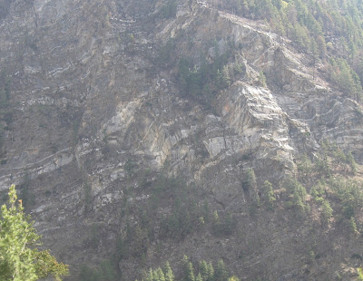
Coming back to the brittle versus ductile deformation regimes. Almost all the deformation you observe in the Greater Himalaya took place in the ductile regime. Here are a few examples from the Greater Himalaya of ductile deformation seen in schists and gneisess. These are my observations from various treks in the Kumaon. 


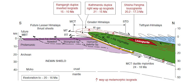
A cross section of the Himalaya is presented here to showcase the metamorphic gradients along the Greater Himalaya slab (green). For this reading, you can ignore the rest of the Himalaya orogen shown in the figure. Temperature gradient increases towards the core of the slab with kyanite (k) and sillimanite (sill) as the prime high grade metamorphism indicators. This example is from the Nepal Himalaya, but the arrangement of the different Himalaya divisions is identical in adjacent Kumaon. 

 Source: Mike Searle et.al. Tectonophysics 2017

Notice the localization of mylonites along the Main Central Thrust zone. Metamorphism of rocks above around 600 degree centigrade during the Eocene (~35 million years ago) and in the Miocene (~25-16 million years ago) has resulted in the ubiquity of ductile deformation observed in the Greater Himalaya. In hotter pockets in the core, metamorphic rocks partially melted and the resulting granitic magma was injected along penetrative weak planes, forming dikes, sills, and small plutons.

Channeled between two great fault zones, the Main Central Thrust at the base and the South Tibetan Detachment as roof, this hot mushy crustal material was then tectonically extruded to shallower levels, its ductile fabrics frozen and preserved as the rocks cooled. Subsequent tectonism has superimposed brittle deformation on the Greater Himalaya ductile structures. 

Finally, another beautiful example of a gneiss showing ductile shearing.  Fish shaped white feldspar are set in a biotite mica and quartz matrix which flows around the porphyroclasts. Can you guess the sense of relative motion?

Observing features that you have seen only in a textbook - that is the great joy of going out in the field.

Sunday, June 30, 2024

Field Photo: Unusual Himalaya Metamorphic Rock

My friend Emmanuel Theophilus, who spends a lot of time wandering in the high Kumaon Himalaya, sent me this photo of a feldspar rich gneiss.,

He observed this loose boulder near the small settlement of Bugdiyar in the Goriganga valley, north of Munsiyari town. Bugdiyar is located in the Greater Himalaya. This is a high grade metamorphic rock terrain. As you walk along the many trails that lead to places like Nandadevi Base Camp and Milam Glacier,  you can observe mica and amphibole rich schist with gleaming garnets, quartz and feldspar rich gneiss, migmatite gneiss (partially melted gneiss), and leucogranite (quartz and feldspar rich magma) intruding this high grade ensemble. 

This traverse takes you into the core of the Himalaya orogen, where high temperature and pressure during mountain building that took place 35 to 15 million years ago transformed the sedimentary protolith into metamorphic rocks. 

This particular gneiss rock has an extraordinary texture. I have never before seen such large feldspar (white crystals) in a metamorphic rock. Judging by the pebbles and other rocks strewn by the side, these are inches long feldspar grains. 

I want to introduce two terms used to describe texture in metamorphic rocks; porphyroblastic and porphyroclastic. Both these terms describe rocks with very large crystals surrounded by fine grained minerals. These are rocks with two distinct crystal size classes. 

Porphyroblastic texture forms when one mineral grows more quickly than other minerals during metamorphism. Large crystals of the rapidly growing mineral are set in a finer crystalline matrix. Both the large and small sized minerals have recrystallized, but at different rates.  

In contrast, porphyroclastic texture forms when there is a size reduction of some minerals , leaving one unaffected mineral larger than the rest. This situation occurs most commonly in fault zones where softer minerals may get crushed more easily leaving the resistant mineral as a large porphyroclast. These types of rocks have a broken appearance. The softer minerals become aligned to give the rock a prominent streaky banded texture. The more competent mineral may also develop an elongated shape.

Which of the above is the rock Theo found? My guess is that it is a porphyroblastic gneiss. Take a closer look at the beautiful large grains. They seem to be the result of growth during metamorphism, in the process engulfing small pockets of mica in their interiors. The rock lacks the streakiness and the often broken, bent, and stretched large grains characteristic of a porphyroclastic texture.

However, there is a subtle sign of deformation too. Have a look at this close up. 

The black arrows point to rugby ball shaped feldspar grains. They have a long axis and a short axis and appear to be stretched in one direction. Also notice the grey cracks running along the longer axis of many of these crystals and continuing into the rock. These are paper thin zones where force or stress was localized. The change in shape (strain) in the feldspar grains follows these very narrow zones of deformation. 

All of the above is my reasoned speculation on the origin of this texture. The next step is to meet up with Theo near Bugdiyar and walk along the Goriganga in search of the outcrop.

The Goriganga near Bugdiyar. It is spectacular out there!

Tuesday, June 13, 2023

Links: Human Brain Evolution, Pyrometamorphism, Upper Atmosphere Cooling

I learned some new things from these articles over the past couple of weeks.

1) Endocranial Volumes and Human Evolution: Warning- this figure posted below is deceptive!

Although hominin brain volumes increase over a 7 million year history, patterns of growth in separate lineages show, both, stasis & episodic increase. In an excellent analysis, anthropologist Ian Tattersall shows that a trend towards large brain volume is expressed independently in three separate hominin lineages, raising important questions about the role of social interactions and environmental pressure that could lead to the evolution of larger brain size. And most intriguingly, brain volume size has decreased in the Homo sapiens lineage over the past few tens of thousands of years. What does it mean for the evolution of complex behavior and symbolism?

2) Scorched Minerals in Sedimentary Rocks: Petrologist Michael Anenburg reports a most unusual suite of minerals. They formed by pyrometamorphism, i.e., the transformation of sedimentary rocks by heat supplied by large fires. This process takes place at or very near the surface, likely driven by the ignition of oil bearing shales or coal seams. The rocks described here are from the Dead Sea area of Israel. Before metamorphism, they were a sequence of impure limestones and phosphorites. There is a memorable description of these combusted limestones in the paper; 

" Gross discovered that the Hatrurim Formation was fundamentally a natural Portland cement factory. Indeed, many of the synthetic compounds found in cement occur naturally in the Hatrurim Formation and were subsequently named after the local Hebrew or Arabic place names in which they were found, such as hatrurite, ye’elimite, and harmunite. Concrete is formed when Portland cement is mixed with water, and the pyrometamorphic minerals of the Hatrurim Formation have experienced a similar process. Hundreds of thousands to millions of years of exposure to rain and groundwater has led to the hydration and alteration of most of the high temperature minerals. The end result is essentially a naturally formed concrete". 

3) The Upper Atmosphere Is Cooling, Prompting New Climate Concerns: The earth's atmosphere is layered. While the lowermost  layer known as the troposphere is warming as we emit more and more carbon dioxide, satellite data shows that the two uppermost layers, the mesosphere and the thermosphere have cooled by 3.1 deg F between 2002 and 2019. Scientists worry about the impact of this cooling on weather patterns on earth. A succinct summary by Fred Pearce.


Author Contact: suvrat_k@yahoo.com

Saturday, April 21, 2018

Everest Summit Limestone

Most people I talk to about geology are aware that the Himalaya formed by the buckling and uplift of crust caught up in the India-Asia collision. But, I do see eyebrows raised when I tell them that the summits of some of the highest peaks are made up of marine sedimentary rocks.

The summit of Mount Everest is a fossil bearing limestone of Ordovician age. These deposits are part of a thick pile of sediments of Cambrian to Eocene age which accumulated on the continental shelf of India. They suffered only shallow burial (up to ~10  km) preceding and during continental collision. They are known formally as the Tethyan Sedimentary Sequence.

What happened to these sediments as they got caught up in Himalayan mountain building? A recent study published in Lithosphere has teased out the deformation and metamorphic history of this limestone.

Polyphase deformation, dynamic metamorphism, and metasomatism of Mount Everest’s summit limestone, east central Himalaya, Nepal/Tibet - Travis L. Corthouts, David R. Lageson, and Colin A. Shaw

These scientists trained Nepalese Sherpa climbers to recover samples from the Everest summit. The location of the samples and the basic geological divisions of the summit is seen in the annotated photograph posted below


 Source: Travis L. Corthouts, David R. Lageson, and Colin A. Shaw 2018

The Everest region is made up of high grade metamorphic rocks of the Greater Himalayan Sequence. They are rocks of the Indian continental shelf of Late Proterozoic (~1000 million years old) to Ordovician (450 million years old) age which were buried to greater depths (up to 20-25 km) during continental collision. These rocks are intruded by leucogranite ( a light colored granite) dikes and sills.

Towards the upper levels, the grade of metamorphism decreases gradationally to upper greenschist facies. The contact between the two metamorphic grades is a shear zone termed the Lhotse Shear Zone. The greenschist faces rocks are termed the Everest Series.  On top of the Everest Series is the 'Yellow Band'. This is a coarse grained marble and calc-schist. The summit limestones (Qomolangma Formation) rests on this Yellow Band. The boundary between them is a fault zone known as the Qomolangma detachment. This fault zone is a strand of the South Tibetan Detachment (STD) that puts the Tethyan Sedimentary Sequence (TSS) on top of the Greater Himalaya Sequence throughout the extent of the Himalaya.

A schematic cross section depicting this stratigraphy is shown below.


Source: Travis L. Corthouts, David R. Lageson, and Colin A. Shaw 2018

Researchers used three types of analysis to figure out the geologic history of the limestone.

a) Microfabric analysis of the samples gave the geologists clues to the deformation and stress regime experienced by the summit limestone. The limestones have been converted into a mylonite. This means that increased temperatures and pressures from faulting resulted in a new textural arrangement in which the original calcite grains of the limestone were recrystallized and deformed. New calcite crystals grew flattened and stretched along one direction, resulting in a foliated (layered) streaky appearance to the rock. This texture forms during ductile deformation in a compressive stress regime. Geologists found that near the vicinity of the Qomolangma fault, a set of dilational fractures indicating extensional forces cut across these ductile deformation textures. This indicates that the summit limestone was subjected to tensile forces and normal faulting at a later stage.

b) Titanium content of quartz and biotite from samples close to the South Summit (EV6) indicated the temperature of metamorphism. This is so because the amount of Ti incorporated in to growing crystals of quartz and biotite increases with increase in temperature of crystallization. Results indicated that the limestones at the base of the Qomolangma Formation experienced temperatures as high as 500 deg C. 

c) The age of metamorphism was estimated by dating muscovite crystals using Ar40/Ar39 technique. Muscovite crystals grew in response to the increased temperature and pressure the limestone was subjected to during Himalayan orogeny. Dates show that there were two phases of mineral growth. The first at 28 million years ago, and a younger phase at about 18 million years ago, indicating separate events of movement and heating along the Qomolangma fault zone.

The leucogranite sills and dikes, which intrude the underlying Greater Himalaya Sequence, also merit a mention. They formed by the partial melting of the crust during Himalaya orogeny.  As this magma intruded and solidified inside the Greater Himalaya Sequence, they expelled fluids with volatile elements which permeated into the overlying limestone. This caused metasomatism and crystallization of secondary minerals in the limestone. Boron, potassium, titanium and H2O were introduced into the limestone and were incorporated into minerals like muscovite, biotite and quartz. This activity is dated to about 28 million years ago based on the age of secondary muscovite in the lower parts of the summit limestone.

The sequence of geologic events is summarized in the graphic below:


Source: Travis L. Corthouts, David R. Lageson, and Colin A. Shaw 2018

And an excerpt of the conclusions from the paper-

The different fabrics and metamorphic temperatures observed between the upper and lower parts of the Qomolangma Formation are the result of distinct events that influenced the summit limestone at different times throughout Himalayan orogenesis. Fabrics seen in summit samples are the result of Eohimalayan deformation and low-grade metamorphism associated with initial thrust faulting, folding, and crustal thickening of the Tethyan Sedimentary Sequence in the Eocene. In contrast, the fabrics and elevated temperatures preserved in South Summit samples are the result of events that occurred in the late Oligocene and early Miocene, including metasomatism associated with Neohimalayan metamorphism and normal faulting on the South Tibetan detachment. This means that several significant tectonic events in Himalayan orogenesis are preserved in the Qomolangma Formation, a succession of deformed Ordovician limestone that now comprises the top of Mount Everest.

Open Access.

Tuesday, October 10, 2017

#Neatrock Entry For Earth Science Week

SciFri Science Club is hosting a #Neatrock challenge as part of Earth Science Week.

Here are my two entries:

Megascopic #neatrock:


This is a migmatitic gneiss from the Greater Himalayan Sequence, Darma Valley, Kumaon Himalaya. Migmatite means a mixed rock made up of a metamorphic host and a newly formed igneous rock. During continental collision, metamorphic rocks buried to great depths and subject to high temperatures may partially melt to form granite magma. The granitic melt segregates into layers. The resultant rock is composed of the original metamorphic host rock such as a gneiss (dark bands)  and granitic igneous layers (lighter bands). This migmatite formed during the Miocene.

Microscopic #neatrock:


This photomicrograph of a Late Ordovician limestone (Fernvale Limestone) from Georgia, U.S.A.  is close to my heart. It formed an important part of my PhD work.  I have stained the thin section with a Potassium Ferricyanide dye. Calcite containing minor amounts of iron (Ferroan calcite Fe+2) is stained blue. Non Ferroan calcite is unstained.  In the center of the photomicrograph is a non ferroan 'dog tooth' spar. It is a calcite crystal with a shape resembling a canine tooth of a dog.

This calcite has a pendant habit. It is hanging from the underside of a particle, in this case a piece of an echinoid shell. Such pendant crystals precipitate in a vadose zone i.e. above the water table.  In this environment, pore spaces are not completely filled with water. Rather, films of water coat grains and form drips. These drips become saturated with calcium carbonate and calcite precipitates from them.  Just like a larger and more familiar stalactite in a cave! Except that this micro-stalactite in tiny..tiny.

Development of a vadose environment indicates that sedimentation was interrupted by a large sea level fall. The sea bed got exposed to rain and a fresh water aquifer developed in the sedimentary deposits.  A tiny 'dog tooth' spar can tell us a fair bit about sedimentary basin evolution and sea level history.

Tuesday, June 20, 2017

Quiz: Spot The Granite Intrusion

I came across this glacially transported boulder in the Dugtu village valley near the Panchachuli Glacier in the Kumaon Himalaya.

It is a block of high grade gneiss intruded by a granite. Without scrolling beyond the first photograph, try to work out the contact between the gneiss and the granite.


Answer:

The boulder is encrusted by moss. There is some mineral staining too. And sunlight falling on the rock gives it a speckled appearance.. All this reduces the contrast in color between the gneiss and the granite.

But there is a vital clue in the orientation of structures. Both the gneiss and the granite have a planar fabric imprinted on them.

The fabric of the gneiss is due to the orientation of platy minerals like micas stacked in layers, alternating with layers richer in quartz and feldspars. Assume this is the original disposition of the rock as well. The gneiss layering you see is due to the trace of horizontal planes of separation of different mineral layers. I have outlined some of this planar fabric in brown lines.

The granite has a planar fabric too, but this is due to near vertical fractures. The rock has been broken in to thin slabs  by fractures (red lines) which may have formed during the cooling of the magma. These fractures don't pass into the surrounding host gneiss. Two arms of the granite have penetrated between the gneiss layers forming mini sills.

You can see the contact (black line) between the gneiss and the granite roughly where my wallet is. Here, the horizontal planar fabric of the gneiss abruptly juxtaposes against the vertical planar fabric of the granite.


Thursday, June 15, 2017

Field Photo: Glacial Erratic

Inspired by this xkcd comic:


I saw quite a few of these glacial erratics in the Dhauliganga river valley around the villages of Dugtu and Dantu. Here is my friend sitting on one of them.


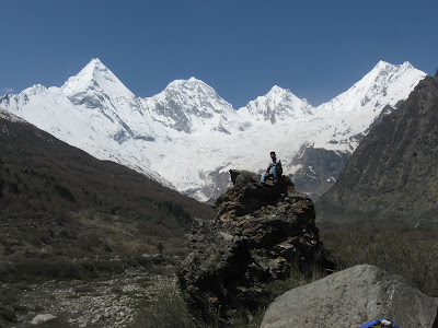
This boulder is a high grade gneiss. It is an erratic because the surrounding bedrock is all low grade phyllite and slate. The source of the high grade gneiss boulder is the snow capped range you see in the background. These are the Panchachuli peaks and the Panchachuli glacier has eroded, transported and deposited gneiss rocks all the way down the valley onto a different bedrock.

The photo below shows another erratic from this valley. If you look closely it is a mixed rock made up of high grade gneiss intruded by light colored granite. A big patch of dark grey banded gneiss is visible in the lower right corner of the boulder. The cliffs in the background and the substrate on which the boulder rests is low grade phyllite.


And a long view of village Dugtu with glacial erratics strewn all over the hill slope (blue arrows).


I have been promising a post on the glacial deposits of the Dhauliganga river valley. That post will come soon. Meanwhile, here is a view of some of the moraines I saw near village Dugtu.  Photo taken from near the snout of the glacier facing downstream.


The linear ridge in the center of the photo made up of rust, brown and light colored boulders is a medial moraine. It was formed when two glacial streams carrying debris along their edges joined. As these glaciers receded the debris along their edges (lateral moraines) coalesced and formed a ridge in the center of the valley. You can see the milky white colored Dhauliganga river flowing to the right of the ridge. The blue arrows to the right of the picture high up along the mountain slopes point to older lateral moraines deposited when the Panchachuli glacier was thicker and extended further down in the valley...

more on these deposits later..

Thursday, June 1, 2017

The Serpents Of Nagling- Granite Intrusions Into Greater Himalayan Sequence Metamorphics

Over chai, elders told us about large serpents invading their village. A curse, they said. Only the correct prayers and purification rituals saved them, forcing the serpents to retreat deep into the forest. Some serpents remain trapped in the rock faces near the village, which was renamed Nagling (Nag means cobra..or more generically serpent).

The picture below are the entombed serpents of Nagling (trekkers for scale).


Geologists recognize them to be granite dykes (intrusions cutting across host rock layering) and sills (intrusions parallel to host rock layering) intruding the high grade metamorphic rocks of the Greater Himalayan Sequence (GHS).

The GHS is a block of the Indian crust bounded between the Main Central Thrust (MCT) at the base and the South Tibetan Detachment System (STDS) at the top. It represents mid crustal material which was metamorphosed and then was extruded and exhumed during Himalayan orogeny between 25 million years ago to about 16 million years ago. These dates vary somewhat along the strike of the Himalaya. Thrusting along the MCT took place earlier in the western Himalaya. Eastern regions like the Sikkim Himalaya record younger dates for the movement of the MCT.

The grade of metamorphic varies within the GHS. The figure below is a schematic section of the Greater Himalayan Sequence. It is from a study on the nature of the MCT by Michael Searle and colleagues from the Nepal Himalaya and is a very useful guide to think about the internal structure of the GHS.


 Source: Searle et. al. 2008

From the base of the MCT the grade of metamorphism increases towards higher structural levels. This is recognized as an "inverted metamorphic gradient", since minerals that are formed at higher and higher temperatures and pressures are occurring at structurally higher and by implication apparently shallower levels of the crust. The inverted gradient is recognized by the successive appearance of  biotite, garnet, sillimanite and finally kyanite. The sillimanite-kyanite zone transitions into the zone of partial melting and granite intrusives. This is the zone where the crust experienced conditions that lead to the formation of in situ melts and their mobilization and intrusion into surrounding rock. Above this zone the grade of metamorphism reduces towards the STDS. In the figure, the granite intrusion zone is directly overlain by the STDS and the Tethyan sequence. However, there is variation in this theme across the Himalaya. In the Kumaon region where I was, the "melt zone" is overlain by a sequence of lower metamorphic grade phyllite rocks.

What caused this melting and production of granitic magma? Many geologist point to the STDS. They suggest that this zone of extentional faulting stretched and thinned the crust, resulting in " decompression-related anatexis". This means that when extentional faulting along the STDS and exhumation reduced the overburden on deeply buried hot rocks, the release in pressure resulted in the lowering of rock melting point. This led to a partial melting of the crust (anatexis). Other geologists disagree with this explanation. They point out that since decompression has a minor effect on melting the likely source rock compositions you would require unreasonably large amounts of denudation along the STDS.  Rather, they suggest that crustal thickening by the continued convergence of India with Asia elevated temperatures in the middle levels of the crust to a range where partial melting began. These melts then moved along weak planes and intruded the surrounding GHS above the sillimanite and kyanite grade gneisses. The main pulses of this magma generation took place between 24 million years and 19 million years ago.

Geologists estimate the temperatures of this melt zone to be around 650 deg C to 750 deg C, corresponding to a  burial depth of about 20-25 km. Yes, the GHS represents crust that has traveled from that depth to the Himalayan heights it now commands by a combination of thrust faulting and erosional unroofing i.e. the stripping away of shallower levels of the crust!

During one of my previous treks in the Kumaon region I had walked across the GHS from the base of the MCT to the sillimanite zone in the Goriganga valley from the town of Munsiari to village Paton. This time, one valley to the east,  we began our trek at village Nagling in the zone of  partially melting. All around us were rock faces intruded by sill complexes and dykes. The picture below shows multiple sills of granite cross cut by dykes.


High up from Nagling village towards Nagling Glacier I saw this granite dyke complex (outlined by red dotted lines ) cutting across metamorphic banding (black lines).


And in the stream near Nagling Glacier I came across this rounded stream boulder showing granite cross-cutting banded migmatitic gneiss.


We traveled north and  reached Duktu. Earlier, somewhere near the village of Baaling, we had crossed the zone of partial melting and were in the uppermost levels of the GHS made up of phyllite grade metamorphic rocks. The phyllites are not intruded by granite.

However, granite was present at Dugtu too, but only in the Dhauliganga river bed. This river emerges from the Panchachuli Glacier. The Panchachuli ranges which fall lower in the GHS are made up of high grade gneiss intruded by granite.

As a result, the Dhauliganga river bed near Duktu village is choked with boulders of granite and migmatite rocks.


This is a very distinctive  biotite-tourmaline granite. The picture below shows blocks of granite with tabular black tourmaline.


Here is a picture of me looking intently at a block of GHS made up of a granite intruding in to a gneiss.


And another close up of light colored granite intruding dark grey banded gneiss and encircling and enclosing rafts of the metamorphic host rock (red arrows).


And finally, from the sheer rock faces near Nagling Glacier, one of my favorite examples of the granite intrusions. A near vertical dyke (red broken outline) cut and displaced by a fault (yellow broken lines). Metamorphic banding shown in black lines.


... Pleistocene-Holocene glacial deposits of the Panchachuli Glacier area.. coming up next!

Monday, January 11, 2016

Blueshist Facies And An Exam Written Long Ago

Bear with me.

Abstract:

Emergence of blueschists on Earth linked to secular changes in oceanic crust composition - Richard M. Palin and Richard W. White

The oldest blueschists—metamorphic rocks formed during subduction—are of Neoproterozoic age, and 0.7–0.8 billion years old. Yet, subduction of oceanic crust to mantle depths is thought to have occurred since the Hadean, over 4 billion years ago. Blueschists typically form under cold geothermal gradients of less than 400 °C GPa−1, so their absence in the ancient rock record is typically attributed to hotter pre-Neoproterozoic mantle prohibiting such low-temperature metamorphism; however, modern analogues of Archaean subduction suggest that blueschist-facies metamorphic conditions are attainable at the slab surface. Here we show that the absence of blueschists in the ancient geological record can be attributed to the changing composition of oceanic crust throughout Earth history, which is a consequence of secular cooling of the mantle since the Archaean. Oceanic crust formed on the hot, early Earth would have been rich in magnesium oxide (MgO). We use phase equilibria calculations to show that blueschists do not form in high-MgO rocks under subduction-related geothermal gradients. Instead, the subduction of MgO-rich oceanic crust would have created greenschist-like rocks—metamorphic rocks formed today at low temperatures and pressures. These ancient metamorphic products can hold about 20% more water than younger metamorphosed oceanic crust, implying that the global hydrologic cycle was more efficient in the deep geological past than today.

Blueschist facies metamorphic rocks contains a  very typical mineral assemblage of glaucophane, epidote, jadeite, albite and chlorite. The blue color  is due to Glaucophane which belongs to the sodic amphibole group of minerals.

I had read Miyashiro's book on metamorphic facies during my graduate studies in India, and then  again  as I appeared for the CSIR (Council of Scientific and Industrial Research)  scholarship exam. It served me well. One of the questions in the exam was to explain the absence of blueschist facies metamorphic  rocks from the Archean record.

There could be two explanations I had learnt. One is  that these rocks did  exist in the Archean but had been subsequently re-metamorphosed to a more stable  assemblage. The problem is to explain why there is not even a single instance where the transformation is incomplete and blueschist facies partially preserved at some Archean age subduction complex somewhere on earth. That left the other explanation as the stronger one i.e. such metamorphic rocks did not exist on earth in the Archean due to higher heat flow. I think I wrote a good answer and generally did quite well as I cleared the exam and won the scholarship.

This study also links the high heat flow on early earth to the absence of blueschist facies rocks, but in a different way. High heat flow would have meant greater amounts of partial melting of mantle rocks,  resulting in greater amounts of refractory magnesium partitioning into the magma. Such high magnesium content ocean crust then would have metamorphosed into the Mg rich greenschist type rocks instead of blueschist varieties.

The paper mentions greenschist rocks. There are plenty of them in the Archean terrains of India. The green color is due to minerals like chlorite and hornblende. They form linear belts of low-medium grade metamorphic rocks, formed by the transformation of mafic volcanic and clastic sedimentary rocks formed in an oceanic setting and deformed during events of subduction and orogeny. Some of the best metamorphic mineral collection tours are in such terrains, with rich pickings of garnet, tourmaline, flourite found in the large quartz veins that intrude these greenstone schists.  Many a college geology tours have trampled the greenstone belts of south India near the towns of Dharwad, Chitradurg  and Shimoga.


 Source: Wiki
 
I never had to dabble in metamorphic petrology again as my research took me a world away into carbonate sedimentology. But Miyashiro's elegantly written book I remember.