Showing posts with label Geology of India. Show all posts

Friday, May 1, 2026

Across The Eparchean Unconformity

An unconformity is a gap in the recording of earth's history, similar to missing pages in a book. These breaks are more common than is realized. Stratigraphers, who organize geologic history, estimate that the time spans of non deposition exceed that of episodes of deposition. These gaps could be fleeting, as in a river meandering away and then reoccupying the old channel, or they could indicate conditions of non deposition and erosion lasting tens to even hundreds of millions of years.

Geologists recognize a hierarchy with the longer lasting breaks often pointing to major changes such as a mountain building phase accompanied by a prolonged sea level fall. As sediment deposition stops, erosion will often sculpt the top of the rock formation into an uneven surface. Eventually sediment deposition will resume. Geologists term such a break between the two phases of rock formation as an erosional unconformity.

Recently, the Geological Survey of India added the Eparchean Unconformity to its growing list of Geo-Heritage sites of national importance. This is one of those major long lasting erosional breaks seen in the Precambrian terrains of India. The chosen site is near Kalinjar Fort, in Banda District of Uttar Pradesh. Image Source: Geological Survey of India.

At this location, 1.2 billion year old sandstone of the Vindhyan Basin overlie 2.5 billion year old Bundelkhand granites marking more than a billion years of non deposition and erosion. While the amount of unrecorded time is significant, the real importance of this site is in the very different earth conditions represented by the older Bundelkhand granite as compared to the much younger Vindhyan sandstone. This unconformity marks the transition between the older Archean Eon and the younger Proterozoic Eon.

The Archean was a much hotter world. Melting of the earth’s mantle was producing large batches of silica rich magma which solidified to form buoyant continental crust, small rafts at first, growing into larger blocks as time went by. Vertical crustal movements created narrow depressions which got filled with lava and sediment eroded from nearby granitic highlands. These volcano-sedimentary successions were deformed and metamorphosed, and were preserved as enclaves within the granitic terrains.

By around 2.5 billion years ago, magmatic growth of continents petered out. Geologists estimate that around 70% of the present volume of continental crust was generated between 4 billion to 2.5 billion years ago.

As the mantle cooled, the more stable continental crust became the floor for a younger generation of sedimentary basins. The processes of chemical weathering and sediment transport became more prolonged on this wide gently subsiding continental terrain. As a result, waves and currents had more time to sort sediment by size, shape, and density before it was buried.

Thick deposits sorted by size into gravel, sand, and mud are the typical features of these younger basins. At places, ocean water saturated with calcium carbonate precipitated layers of calcite and aragonite sediment, preserved today as thick limestone. The biosphere was dominated by bacteria and unicellular eukaryotes, their morphology often imprinted on the rocks as wavy layers or as small mound shaped objects.

Magmatism and continental crustal growth continued less frequently in pulses coinciding with regions of plate convergence and orogeny. This phase, before large animal life evolved, lasting between 2.5 billion years and 539 million years ago is known as the Proterozoic Eon.

The newly listed National Geological Monument at Kalinjar Fort showcases these changing earth conditions.

For many decades though, exactly where to place the Eparchean Unconformity was something of a problem in Indian field geology. There was only sparse information on the absolute age of rocks and no consensus on the time span the Archean represented. Field mapping through Peninsular India indicated the presence of a distinct erosional break between deformed and metamorphosed rocks (crystalline basement) and younger flat lying or less deformed sediments. This appeared to be the natural horizon between the Archean and the Proterozoic.

But flat lying sedimentary sequences in different Indian basins, often referred to as Purana Basins, had been deposited at different times on older deformed rocks of varying ages. In some cases the foundation of the sub-horizontal sedimentary basins was indeed Archean. In other locations, the highly metamorphosed and deformed older rocks were actually Proterozoic. That meant that the Eparchean Unconformity, as earlier conceived, was not a useful marker of synchronous changes in earth processes. Many of these doubts are summarized early in this 1968 perspective on the Eparchean Unconformity by Dr. T V V G R K. Murthy, faculty at University of Sagar.

The dates for the Archean-Proterozoic transition have now been fixed at 2500 million years by the International Subcommisson of Precambrian Stratigraphy, without any condition regarding the rock type above and below the unconformity surface. As a result, the older criteria for identifying a particular erosional break as the Eparchean interval based on only rock types and extent of deformation was no longer tenable.

We finally have an answer for the question posed by Dr. Murthy so long ago:

“Does the eparchaean unconformity become evident by recognizing Archaean and Purana formations or are the Archaean and Puranas recognized by identifying the eparchaean unconformity”.

Today, better absolute dating of rocks makes differentiating Archean from Proterozoic rocks easier. The Eparchean Unconformity though is still an informal but useful term in Indian field geology signifying the cooling trajectory of the earth’s interior, with a hotter Archean transitioning to a cooler Proterozoic.

One of my earliest encounters with the Eparchean Unconformity occurred during my graduate studies. I was assigned to map an area of the Cuddapah Basin near Gani village in Andhra Pradesh, South India. I first traveled by the Dadar -Madras (now Chennai) Express to Guntakal. There, I transferred to a medium gauge train passing through small market towns connecting a vast hinterland an urban kid like me was unfamiliar with. The train chugged along eastwards towards Nandyal. For a couple of hours from Guntakal, we were firmly on Archean terrain, an agricultural landscape interrupted by small hillocks of granitic rocks. In a distance through the late morning haze we could see the low Cuddapah hills with their distinct tilted strata.   

The train crossed the Eparchean Unconformity and entered the Proterozoic through a breach in the Cuddapah hills at Dhone Junction. Ahead was the Cuddapah Basin stretching to the horizon.

We moved through quartzites, limestone, and shale, the three predominant sedimentary rock types of the shallow marine Proterozoic continental shelf. At Nandyal I had to hop onto a bus going to Kurnool. Gani village was midway between these two places. I remember arriving at Gani late evening to a warm welcome by my host Mr. Sivanand Rao. Next morning, with maps and aerial photos, hammer, and a geologic compass I started out. A half hour walk south of Gani were outcrops of the sedimentary rocks I had to map. It was a challenging and immensely satisfying introduction to field geology.

Picture shows a very youthful me and my field guide Yanganna standing in front of a quartzite hill. Captured by my accompanying batch mate Nitin Rane. June 1987.


Someday soon I hope to retrace my steps to little Gani village. The medium gauge tracks from Guntakal to Nandyal have long been replaced by standard gauge. Express trains pass through Nandyal, eventually swerving north towards Vishakapatam, or continuing south east towards the Coromandel Coast.

From Nandyal I may hire a car to Gani. I hope to meet Mr Sivanand Rao who so graciously hosted me over two field trips. I want to walk again towards the hills made of Paniam Quartzite, a sand deposit sorted and washed clean by powerful Proterozoic tides. Today, the Kurnool-Gani solar park stands near Gani, its tilted solar panels made up of ultra pure silica wafers making up an Anthropocene analogue of the more ancient quartz rich deposits.

Photomicrograph shows the Proterozoic Paniam Quartzite classified as a “super mature quartz arenite”. Notice the well rounded quartz grains outlined by iron oxide. Location - Gani anticline.

Beyond the quartzite hills are the Vempalle Formation dolomite, a vestige of the Proterozoic ocean I first waded in to begin my life long association with carbonate sedimentology. It will be a home coming of sorts for me.

Photomicrograph shows microbial layers in the Vempalle dolomite. Dolomite crystals of different size and shape have replaced the original organic mats. Location- Gani anticline.

I have one more incentive to relive this journey. The filter coffee at Guntakal railway station canteen. It is the very best.

Friday, August 22, 2025

Easterly Tilt Of The Deccan Plateau - Update

I first wrote about this topic in 2011 in response to a question by a reader. I thought I would update my post with some new maps and explanations. Why is there such a pronounced pattern of easterly flow of the rivers in the Indian Peninsula.  I keep getting asked this question.  It was time for an update on this interesting topic on geology and landscapes. 

The region south of the Tapi river covering the Deccan basalts and the southern Indian peninsula exhibits an easterly drainage with the rivers flowing into the Bay of Bengal. The map below shows the Indian peninsular region with easterly drainage. The Deccan Plateau is mostly but not entirely covered by the Deccan basalts. South of this region is the Karnataka Plateau with a Precambrian geology. Along the east coast there are Permian-Triassic and Cretaceous basins.

Source: Hetu C. Sheth: Deccan Beyond the Plume Hypothesis

The question posed to me was - What is the relationship between the Deccan volcanics and the easterly tilt of the Indian plateau (i.e. the plateau covering the Deccan volcanics and the southern Indian peninsular region)?

The easier more intuitive answer would have been that the western ghats provide the topography and Deccan volcanism created a lava pile that is thicker to the west and which thins to the east, thus generating an east sloping surface. Rivers follow the slope to the Bay of Bengal. 

There are some geologic age inconsistency in this answer and this also does also not fully explain why the region south of the Deccan Volcanics too has an easterly drainage. Clearly, something more is going on. 

To understand the evolution of the Peninsular drainage patterns let us look back to the time when the Peninsula didn't exist. In early Mesozoic, India was part of Gondwanaland and was joined to Antarctica and Australia to the east, and Africa to the west. The triangular shape of south India with characteristic eastern and western coastlines had not formed yet. 

How can we find out the direction rivers were flowing back then? Geologists look to clues in the sedimentary basins of that age. The composition of sand in sandstone is matched to the most likely source terrain. And current directions can be inferred from studying ripples preserved on the surface of ancient sand. 

The paleo geographic maps below shows Gondwanaland and the location of the Pranhita Godavari basin in the Mesozoic. 


Source: Sankar Kumar Nahak and Coworkers 2024.

West North West flowing rivers originating in the highlands of the future Antarctica and in the Eastern Ghats were funneling sediment to the basin. Much of the interior of the region that would become the southern Peninsular India was a peneplain. There wasn't much topography towards the west for an easterly drainage network to develop. 

India broke away from Antarctica beginning about 140 million years ago. A distinct eastern continental margin formed. Several NE- SW oriented basins developed along the edge of the Indian continent. Since by this time an expanding Indian Ocean lay to the east, the orientation of a natural drainage system would have been from the west towards the east. 

We can say with some confidence that by 90 to 80 million years ago, east flowing rivers originating in the interior of the Indian continent were depositing sediment along the eastern Indian margin. See this map of sediment distribution along the Indian east coast. 


 Source: K.S. Krishna and Coworkers 2016.

It shows the thickness of  Mid- Late Cretaceous sediment, ranging in age from about 100 million years ago to 65 million years ago. The sediment lobes coincide with the mouths of the Godavari, Krishna rivers and other southern rivers, indicating that the paleo Godavari and the paleo Krishna system had begun building deltas from that time. Since there were no Western Ghats then, these rivers may have been shorter, with their source somewhere in the Archean and Proterozoic terrain of Peninsular India. 

Further to the south, geologists find a similar story with the ancient Cauvery. The Cauvery basin formed when Sri Lanka detached from the Indian continent. Its delta and marine deposits too contains sediment from the Late Cretaceous. 

The easterly drainage pattern of Peninsular India developed before Deccan Volcanism and the formation of the Western Ghats. 

India broke away from Madagascar about 88 million years ago  and subsequently from the Seychelles about 66-64 million year ago. The latter separation coincided with Deccan Volcanism and the eventual formation of the western Indian continental margin. Block faulting that accompanies continental breakup would have created a north south oriented high area, which would eventually evolve into the present day Western Ghats. The thinning of the lava pile to the east also would have created an easterly slope. Rivers originating in the western highland now would flow across the length of the Peninsula. 

New streams would have incised the fresh volcanic surface as lava buried the older etched landscape. But the regional  pattern of easterly flow persisted.

Some geologists maintain that there has been some fairly recent Cenozoic age (past 15-20 million years) uplift of the Western Ghats which has accentuated relief and produced the youthful looking topography of scarps, waterfalls, and deep canyons. These earth movements would have certainly given new energy to the drainage system, but there is some geologic evidence to suggest that the streams originating in the western ghat region are antecedent to the uplift of the ranges. 

For example, in the Mahabaleshwar area easterly drainage cuts across the axis of a north south oriented gentle anticlinal structure, implying that the drainage predates the uplift and warping of lava flows. Evidence from sedimentation patterns of the eastern river deltas also show that the easterly drainage originated much earlier than the formation of the Western Ghats. 

What then created that initial slope to the east that imprinted the drainage network that continues today? 

One reason is that the eastern margin formed first. Basin formation along the eastern edge of the continent would have created a relief difference between the western interior and the eastern depressions, resulting in stream networks flowing eastwards.  Secondly, the new oceanic crust made of lava that formed when India and Antarctica separated in the Late Jurassic and Early Cretaceous would have cooled by Late Cretaceous times. Becoming colder and denser it has been sinking and dragging the Peninsular region with it. 

Earlier eastern basin formation and a tug from the floor of the Bay of Bengal may have been enough to impress an east flowing drainage. Later, the east sloping lava surface and the rise of the Western Ghats reinforced this distinction between the west and the east perpetuating the direction of river flow initiated since Cretaceous times. 

Monday, April 28, 2025

Oldest Himalaya Rocks

In Peninsular India, the most significant change in rock type occur across what is known as the Archean Proterozoic boundary.

Archean rocks, older than 2.5 billion years, are typically varieties of granite and granite gneiss. They formed when the earth was much hotter and silica rich continental crust was growing by injections of magma from the uppermost mantle and by partial melting of older mafic (silica poor) crust. At places the crust subsided by vertical movements, and lava and sediment filled the narrow depressions. These volcano-sedimentary rocks were deformed and metamorphosed to form linear schist enclaves within the granitic crust. The term granite greenstone terrain describes this rock association.

This phase of continental crust building petered out by around 2. 5 billion years ago. The thick crustal blocks or cratons became the nuclei for future continent growth. By 2 billion years ago or so in the Paleoproterozoic (the Proterozoic Eon spans from 2.5 billion years ago to 538 million years ago) , the Archean crust became the floor for several sedimentary basins. Erosion of the Archean rocks provided sediments that accumulated in these basins over the next 1 billion years, with long hiatuses punctuating pulses of sediment deposition. The names of these sites of deposition will be familiar to many readers and travelers.  Aravallis, Vindhyans, and Cuddapah, to name a few, represent this younger Proterozoic phase of crustal recycling. 

There was limited development in Peninsular India of younger sedimentary basins and as a result Archean and Proterozoic crustal sections are widely exposed all across the country.

The satellite imagery posted below shows one classic locality of the Archean Proterozoic boundary. This is from the Cuddapah Basin of South India.  

The Archean granitic terrain has a rough texture due to the bouldery nature of the landscape formed by weathering of fractured granite. Towards the east north east, the layering of sedimentary strata of the Cuddapah Basin is prominent and unmistakable.  The following graphic is a geologic log prepared to describe the succession of rock types from the Cuddapah Basin.

Source: Vivek S Kale and coworkers; Proc. Indian. Nat. Sci. Academy 2020.

Archean 'basement' and Proterozoic 'cover sequence' is a common stratigraphic motif of the Precambrian geology of India.

A few weeks ago I found an old paper from the 1970's on the sedimentology and stratigraphy of Tethyan sequences from the Kali valley area, near the Kumaon Nepal border. These are, as the name suggests, sediments deposited in the Tethyan Ocean along the  northern margin of the Indian continent. They range in age from the Proterozoic to the Mesozoic.

Here is the stratigraphic column from the paper. I have shown only the Precambrian (Archean and Proterozoic collectively make up the Precambrian) section of the column. The Central Crystallines are assigned an Archean age, while the Tethyan Sequence Martoli Formation is Early Precambrian. The name Proterozoic was not in use in the 1970's when this paper was written.

 Source: S. Kumar and coworkers; Journal of Paleontological Society of India 1977.

'Crystalline' in this context refers to the rock texture made up of large interlocking minerals formed during slow cooling of a magma or during high temperature metamorphism of a sedimentary rock.

The geologic sequence I described earlier took place along the northern margin of India too where the future Himalaya would form. At first glance the Himalaya sequence seems a replica of the geology of Precambrian Peninsular India. It records an Archean  'crystalline'  basement, succeeded by variably deformed and metamorphosed Precambrian (Proterozoic) sediments.

Except that it is wrong. There are no Archean age rocks exposed anywhere in the Himalaya. And the rock units immediately in contact with the Archean are not Early Precambrian.

When this paper was published there was precious little geochronology work done in the Himalaya. Geologists knew from sporadic absolute dating of Peninsular rocks that the granite and granite gneiss terrains are older than 2.5 billion years  (Archean).  The thick sedimentary sequences overlying the granite basement also were Precambrian as ascertained by dating intrusive granites and interbedded lava layers. The lack of any shelly fossils in them was another indicator of the Precambrian age of the cover sedimentary sequences. 

Given this familiarity with Peninsular geology, it would have been natural to assign the same chronology to a Himalaya rock sequence of high grade gneiss in contact with unfossiliferous sedimentary rocks. 

The Central Crystallines are now known as the Greater Himalaya Sequence and they are not Archean but Neoproterozoic (Late Precambrian) in age. Detailed work has shown that they represent sediments deposited roughly between 1 billion and 600 million years ago along the northern continental shelf of India. A paleogeographic reconstruction of the Himachal Himalaya by Alexander Webb and coworkers shows the original disposition of the different Himalaya rock divisions. Observe (A) that the Greater Himalaya (GHC) and the lower part of the Tethyan Himalaya (Haimanta/Martoli Formation) were deposited synchronously in adjacent areas of the continental shelf.  

 Source: Alexander Webb and coworkers; Geosphere 2011.

They look very different from each other today because they experienced different conditions during Himalaya mountain building. The Central Crystallines which began their life as marine sediments became crystalline gneisses and schists during high grade Cenozoic metamorphism 35 to 20 million years ago, while the Tethyan Sequence escaped being buried deep in the crust and retained much of their original sedimentary character. 

What about the oldest Himalaya rocks? These are Paleoproterozoic in age, dated to be about 1.9 to 1. 8 billion years old. The units Damtha, Berinag, Wangtu, Jeori and Baragaon in the Himachal Himalaya cross section are the Paleoproterozoic age rocks. They are remnants of a magmatic arc and associated basins which formed along the northern margin of India when continental blocks were colliding and suturing into an early supercontinent named Colombia.

Underneath these Paleoproterozoic rocks would have been the Archean 'basement'. But where is it now? 

We can take a step back and understand how the Himalaya are constructed. As the Indian continental crust collided and pressed into Asia, a crack or a fault initiated in the collision zone started propagating southwards, slowly splitting the Indian crust.  As India kept getting pushed under Asia along this master fault, slices of Indian crust get scraped off  and thrust upwards along subsidiary faults to form a growing mountain range. This tectonic evolution is depicted as stages B, C, D, E, F. You can also read my post Himalaya: A Critical Wedge for more details on the mechanisms of mountain building.

If as shown in the cross section, the faults that break and transport crustal sheets are located entirely within the Proterozoic and younger layers then the Archean rocks won't get incorporated into the Himalayan orogen. They lie below the basal detachment/master fault. Alternatively, this model may not be applicable everywhere in the Himalaya and there may be slivers of Archean rocks buried deep under the thrust pile, but erosion hasn't exposed them yet. 

In the geologic future, the plate tectonic engine that made the Himalaya will change track. The mountain ranges will stop growing. Erosion will wear down the Himalaya and eventually lay bare its roots. The Archean 'crystalline basement' so familiar all over Peninsular India will also be visible at the base of the gentle rolling hills that were once the mighty Himalaya.

Tuesday, July 30, 2024

Remotely India: Bundelkhand Mafic Dikes and Quartz Veins

Remotely India #14

Do you see anything striking (pun intended) about this geologic map of the Bundelkhand craton?

Notice that the green lines are predominantly oriented in a NW-SE direction. The pink lines are predominantly striking NE-SW. These are magmatic and fluid intrusions into the Bundelkhand granitic crust. The green lines represent mafic dikes (Mg and Fe rich basaltic magma), and the pink lines represent quartz veins. 

The Bundelkhand craton is an Archean age block of continental crust. Like other Archean age terrains, it has a long history of magmatism, volcanism, and sedimentation. The oldest rocks, a suite of granitic rocks going by the term 'tonalite–trondhjemite–granodiorite', and associated volcanics and chemical sediments are as old as 3.4 billion years. Through the Archean the crust grew by repeated injections of magma. Voluminous magmatism petered out by around 2. 4 billion years ago with the formation of the Bundelkhand granodiorite batholith, an enormous subsurface body of congealed magma. Granodiorite is a calcium feldspar bearing variant of granite. This younger rock type covers most of the surface area of this terrain.

Geologic activity continued for hundred of millions of years after the emplacement of this batholith with the intrusion of these impressive dike swarms and quartz vein clusters.

Staying true to the objective of this series on Indian geology as seen from satellite imagery, the emphasis here will be on the field features of these intrusive bodies.

Giant Quartz Veins:

Locality- Northeast of Mauranipur, Uttar Pradesh.

The quartz vein stands out as a high long ridge. Steep sided blocks of quartz make up the spine of the ridge. Weathered boulders shed from the quartz vein have formed the surrounding slopes. This distinctive landform is instantly recognizable in the imagery as you explore this region.  

Locality: Southeast of Mohangarh, Madhya Pradesh.

Here you can observe the intrusive relationship between the giant quartz vein and the older Bundelkhand granite (BG) which crops up as low hills made up of a light toned fractured rock. The linear vein can be traced cutting across the host rock.

Locality: Southeast of Mauranipur, Uttar Pradesh.

At this location you can observe an unusual feature. Two quartz veins have split to form a tuning fork shaped geomorphic feature.

These quartz veins intruded the crust around 2.15 to 2 billion years ago. The quartz crystals contain bubbles of gas and minuscule amounts of liquid trapped inside them. They inform us about the temperature and pressure during precipitation of the crystals and about the salinity of the fluid. There are also tiny crystals of other hydrous minerals like chlorite and epidote found inside the quartz. These reveal the source of the fluid. Such studies conducted by Duttanjali Rout and colleagues identify two distinct sources of fluids involved in the formation of these veins. A hot moderate salinity fluid derived from the Bundelkhand granodiorite mixed with meteoric water percolation downwards through fractures. The deeper fluids were sourced from not more than 5 km in the subsurface.

A drop in the temperature and pressure of the rising silica saturated fluid as it encountered the colder meteoric water resulted in decrease of silica solubility and the precipitation of quartz. The giant quartz veins are the product of a vigorous Proterozoic geothermal system that lasted tens of millions of years. The researchers have drawn a comparison with Broadlands-Ohaaki geothermal system in Northland, New Zealand, and the Kakkonda geothermal system in NE Japan. Both are in granitic terrains and could be loose analogs for the processes in operation during the formation of the Bundelkhand quartz veins.  

There are differences in what we can observe in these ancient and modern systems. In the Proterozoic example, the surface expression of the silica rich geothermal system, the hot springs and geysers, have long since eroded away. We can study only the subsurface plumbing system. In the modern settings, the surface processes are apparent and the underground patterns of fluid flow have to be inferred. 

Mafic Dikes:

Locality- Northeast of Lalitput, Uttar Pradesh,

A NNW-SSE trending dike is exposed near Tera village. The surface expression of mafic dikes is very different from the quartz veins. The dikes weather away faster and are exposed as low relief hills with extensive boulder fields derived from the weathering of the dolerite rock. In the satellite imagery, you can see the dark toned nature of the boulders hinting at its mafic composition. Due to the spread of boulders around the dike, the width of the intrusion appears far more that its true width. 

Locality- Mahoba , Uttar Pradesh

An ENE-WSW trending mafic dike is surrounded by Mahoba town. As with the NW-SE trending cluster, these E-W trending intrusions also appear as dark toned low relief boulder strewn hills.

Locality- Mahoba, Uttar Pradesh.

This is a synoptic view of the E-W trending dike, captured by ISRO Cartosat. The white rectangle in the lower left of the image is the bounding area covered by the previous imagery. It is quite an extensive intrusion, and to the eastern end it can be seen cutting across outcrops of the Bundelkhand granite. 

Geochronologic work on these mafic dikes shows that the NW-SE trending dike swarm intruded around 1.9 to 1.8 billion years ago. The E-W trending group of dikes are much younger, dated to about 1.1 billion years ago. 

The geochemistry of these dikes point to an upper mantle source of the magma. The dikes are a variety of thoeliitic basalt, not too much different from the basalts of the Deccan Traps in Maharashtra. Unlike the shallow sourced fluid of the quartz veins, the source magma of the dikes was generated at least 50 km down in the mantle lithosphere.

The crisscrossing lines you see on a geologic map of the Bundelkhand craton are a record of geologic activity that continued long after voluminous granitic magmatism ended. In rare exposures, mafic dikes are seen cutting across quartz veins, indicating that they are the younger of the intrusives. Most of the geochronology data collected so far supports this field observation. Studies of the spatial patterns of the dikes and quartz veins too hint that they represent two independent deformation events. The formation of both these systems required extensive fracturing and faulting  of the crust by extensional forces. Geologists are still working out the reasons for these crustal disturbances. 

In the case of the quartz veins, the fracture systems tapped relatively shallow sources of heat and fluids. In the subsequent reactivation of the crust, much deeper fracture systems cutting across the crust tapped upper mantle sources of heat,  providing conduits for the passage of mafic magma to shallower crustal levels. 

These deep crust penetrating fractures and Proterozoic mafic dike swarms tell another story about the strength of the crust and the advent of plate tectonics, but that is fuel for another post!

I am having fun resurrecting my Remotely India series. Stay in touch for more explorations of Indian geology on this blog.

Monday, May 20, 2024

Remotely India: Chittagong Tripura Fold Belt

Remotely India #13

Did you know that the easternmost part of the Bengal delta is being compressed into folded hill ranges? These go by the name Chittagong Tripura Fold Belt (CTFB), also referred to by geologists as the Outer Indo Burman (Myanmar) Ranges.

Take a look at the annotated satellite image below. The CTFB appears as a series of north south oriented ridges and valleys, extending from northern Tripura to south of Cox Bazaar in Bangladesh. 


Structurally they are made up of strata folded into anticlines (upwarps) and synclines (downwarps). To the east, they are separated from the inner Indo Burman (Myanmar) Ranges (IBR) by the north south trending Kaladan Fault. The Chittagong Coastal Fault marks the westernmost boundary of this fold belt, although the sedimentary pile below the sea bed of the Bay of Bengal to the west is also deforming. The 'deformation front' of this terrain is therefore further to the west of the Coastal Fault. 

As you might have guessed, these fold belts are a result of the Indian tectonic plate converging with Asia. But the nature of tectonic plate interaction is different from the plate collision that formed the Himalaya. In the case of the Himalaya, the continental crust of the Indian plate has collided with the continental crust of the Asia plate. The lower part of the Indian continental crust has slid under Tibet while thick slices of the Indian upper crust have been thrust up by faults to form the different geologic units of the Himalaya. 

Tracing the mountain arc southwards from its bend around Arunachal Pradesh, a different type of tectonic plate interaction is unfolding. In the Himalaya collision zone the more buoyant continental crust is sliding at a shallow angle underneath Tibet, a process known as underplating. In contrast, the Indian tectonic plate along this eastern convergence zone is made up of denser oceanic crust. As a result, along the zone of contact with Asia, this dense plate is subducting or taking a deep dive at a steeper angle into the mantle. 

Another difference apparent from the surface structure is the presence of both vertical and sideways movement of crustal blocks. This occurs because the Indian plate is pressing into Asia at an angle. Oblique convergence results in thrust faulting wherein rocks are moved up along east sloping fault planes. Collision at an angle also causes blocks to slide past each other along strike slip faults.  

The IBR is an older mountain chain formed by the subduction of the Tethyan oceanic crust underneath the Asia plate and the smaller Myanmar plate. This process, initiated in the Late Cretaceous around 100 million  years ago, eventually led to the formation of a complex fold belt by mid Miocene times (15-20 million years ago). 

This fold belt is made up of deep sea sediments and fragments of the Tethyan oceanic plate. These rocks were subjected to very high pressures during mountain building. Sheared and fractured rock units occur in a melange made up of dismembered blocks of varied rock types juxtaposed by faults. Heat and high pressure acting on rocks rich in aluminum, calcium, iron, titanium, and magnesium has resulted in the formation of deposits of exquisite gemstones such as jade, rubies, sapphires, spinel, and peridote. The IBR is studded with precious stones!

By Miocene (~20 million  years ago) the IBR had emerged above sea level as elevated ranges and had started eroding. Sediments shed from these hills were deposited in delta and shallow marine environments of the Bengal Basin to the west. During continued subduction of the Indian plate, between 2-4 million  years ago, this thin skin of the crust made up of about 5 km of sediment was scraped off, faulted, and crumpled up to form the CTFB. Geologists call these scraped off wedges of sediments that form along subduction zones as 'áccretionary prisms'. 

Further to the south, the Andaman Islands is also an accretionary prism formed along the plate junction between India and Asia.

The deformation of the CFTB diminishes from the east to the west. There are two distinct structural domains of this belt. To the east is a more tightly folded belt known as the Eastern Highly Compressed Fold Thrust Zone. Towards the west, is the more open Western Fold Thrust Zone. The emergent part of this fold belt is bounded to the west by the Chittagong Coastal Fault. However, geophysical studies show that the strata below the Bay of Bengal sea bed is also being warped and can be considered part of a westward growing CTFB.

The annotated satellite image below is a close up of the CTFB and the IBR. The black line is the Kaladan Fault separating the two, but even without my annotation, the two terrains have a distinctly different appearance. The older IBR have been more deeply dissected by streams. They have an etched faceted texture. To the west, the younger ranges of the CTFB have a more uniform even texture. 


Finally, I just wanted to put up a structural cross section of the CTFB. The folded and faulted nature of the sedimentary strata is apparent, as is the difference between the more tightly folded eastern zone compared with the more open western domain. Source: Md. Sakawat Hossian et.al. 2022: Lithosphere.

Scientists study terrains like the Chittagong Tripura Fold Belt to understand the mechanical response of the crust to different types of tectonic plate interactions. There is an economic incentive too. The IBR with its precious stone deposits has long been a target of exploration. In the CTFB natural gas seepage has been observed at many places. Geologists are interested in understanding the subsurface structure to target search for hydrocarbon accumulations.

As always, exploring Indian geology from satellite imagery is fun and a great learning experience for me. Stay tuned for more such stories!

Monday, March 18, 2024

Geological Contacts: Angular Unconformity Kaladgi Basin

 Remotely India Series #12

Through the Proterozoic Eon, beginning around 2 billion years ago,  extensional forces acting on continental crust opened up several sedimentary basins across what is now peninsular India. Crustal blocks subsided along faults and these depressions filled in with sediments deposited in fluvial and shallow marine environments. These basins were long lived, some lasting for more than a billion years. 

Sedimentation was not continuous.  Pulses of sediment deposition were punctuated by long periods of non deposition. Tectonic movements deformed early deposited piles of sediment. They were uplifted and an extensive basin wide erosional surface formed.

There was then a renewed phase of basin development. Sediment of these successor basins were deposited on tilted and folded older strata. Commonly, these younger packages of sediments are relatively undeformed. They are preserved as mesas and plateaus made up of flat lying strata. This discordance in attitude between two sets of strata separated by a widespread erosion surface is known as an angular unconformity.

In this post I will highlight an angular unconformity from the Kaladgi Basin from north Karnataka, south India. I have used high resolution imagery from Indian Space Research Organization's Cartosat.  Imagery is available for browsing and download from ISRO's Bhuvan 2D web maps.

The first image shows the area around Ramdurg village. The multi-stage history of the basin is readily apparent. The light colored strata exposed along narrow ridges are folded, while the rust brown hills are made up of undeformed sediments. The light toned strata are quartzites of the Bagalkot Group. The brown sandstone which rest on the Bagalkot quartzites are the Badami Group. Standard annotations show the varying dip and strike of the folded Bagalkot sediments. The white cross in grey circle denotes horizontal Badami strata. 

Kaladgi Basin history has become clearer based on recent geochronologic work by Shilpa Patil Pillai, Kanchan Pande, and Vivek S.Kale. They infer that basin initiation occurred around 1.4 billion years ago. Sedimentation of the Bagalkot Group terminated by 1.2 billion years ago. Movement along major WNW-ESE and tranverse NNE-SSE to NE-SW trending faults deformed the Bagalkot sediments into a series of folds around 1.1 billion years ago. This was followed by uplift and erosion of these folded sediments. Deformation was accompanied by low grade metamorphism of these rocks.

The basin floor subsided again around 900 million years ago initiating deposition of the Badami Group of sediments. The famous cave temples of Badami have been cut out from the lower part of the Badami sedimentary sequence.

The next imagery is a good example on how to recognize the relative timing of deformation events. Arrows point to fracture sets in the Bagalkot quartzites. These lineaments do not extend into the Badami sediments implying that fracturing occurred during an earlier phase of deformation. 


Let's look at a location that shows the angular discordance between the Bagalkot and Badami sediments. This is near Shirur town, north of Badami.  The lighter toned steeply tilted Bagalkot sediments outcrop as E-W trending narrow ribbons, north of Budanagad village. The brown colored Badami sediments form a more extensive plateau. Since these strata are horizontal, the traces of bedding planes form concentric bands mimicking contour lines. 

The final location is just south of Ramdurg village. The unconformity here is a little harder to decipher, but you can make out the tilt of the light colored Bagalkot quartzites, annotated by the standard notation of strike and dip. The quartzites form triangular facets sloping eastwards. Like the previous example, the concentric bands of brown in the adjacent hill indicates that this is the overlying horizontally disposed Badami sandstone.

Many Proterozoic basins of India contain such unconformity bounded sequences. Some more classic examples come from the Chattisgarh, Cuddapah, and Vindhyan basins. These sequences from different basins were not deposited synchronously. Each basin has it own trajectory of sedimentation, deformation, and erosion. 

Detailed field mapping, supplemented by absolute dating of rocks wherever possible, is elucidating the complex poly-phase history of Indian Proterozoic sedimentary basins in the context of global continental breakup and reassembly. For arm chair geologists and enthusiasts, easily available web mapping technology makes it possible to join in the excitement of teasing out these terrain's many secrets hiding in plain sight.

Thursday, March 2, 2023

Tethyan Himalaya And Trans Himalaya

What is the difference between Tethyan Himalaya and Trans Himalaya?

I've seen the two terms being used interchangeably, but geologists recognize them as geologically distinct terrains. Their geographic locations and geologic context has been annotated in the satellite imagery below. 

The Indus Suture is the zone of collision between the Indian and Asian tectonic plates. It contains broken pieces of  oceanic crust and deep sea sediments which were uplifted and jammed between the colliding continents, forming a sort of a geologic no-man's land. The Tethyan Himalaya are the ranges immediately south of the Indus Suture. They are the deformed rocks of the Indian plate. The Trans Himalaya are the ranges north of the Indus Suture made up of a variety of rocks of the Asian plate.

The Tethyan Himalaya is a pile of Paleozoic and Mesozoic sedimentary rocks which was deformed into a fold and thrust belt during the early stages (45-35 million years ago) of the India Asia collision. At places, the sedimentary cover has been stripped away by erosion and high grade metamorphic rocks formed deep in the crust have been exposed. These 'windows' are known as gneiss domes since the sedimentary cover rocks have been arched up during uplift and exhumation of the high grade rocks. The area around the famous Tso Moriri lake is one of the best examples of a gneiss dome.

If your are traveling in Zanskar, Spiti, Lahaul, upper reaches of Kinnaur, and near about Milam and Panchachuli Glaciers,  you are in the Tethyan Himalaya. 

In the late Cretaceous (100 million  years ago), the leading edge of the Indian plate began subducting underneath Asia. As the plate dove deeper it heated up and released water, which triggered the formation of magma in the upper mantle of the Asian plate. This magma rose and assimilated rocks from the Asian lower crust. It then intruded older sedimentary and metamorphic rocks of the Asian crust and solidified as giant bodies of granites and granodiorites (containing calcium rich feldspars). These large granitic intrusions or 'batholiths' range in age from 100 million years to about 50 million years ago. One example is the Ladakh Batholith on which the town of Leh sits. Some of this magma also erupted on the surface through volcanoes. The rocks of Khardungla Pass are remnants of this ancient volcanic terrain. 

A similar situation today is along the western South American margin. There, subduction of the Nazca Plate underneath South America has triggered large scale magmatism and formation of giant batholiths of the Andes Mountains. 

Another impressive geologic feature of the Trans Himalaya is the Karakoram Fault Zone. It is a NW-SE aligned right lateral strike slip fault where crustal blocks have been sliding past each other since about 18 million years ago, resulting in a 150 km of offset of rocks. There has been some vertical movement also along this fault and this uplift has resulted in the formation of the Pangong Ranges where high grade metamorphic rocks have been exhumed from a deeper crustal level. The Pangong Lake is a drowned river valley formed by the damming of the river on its western end due to fault uplift. 

Strike slip faults have been in the news recently. The devastating earthquake in Turkey and Syria was caused by movement along the left lateral strike slip East Anatolian Fault. 

The India Asia collision resulted in the partial melting of deeply buried rocks of the Asian crust in the Miocene (21-16 million years ago) and the resulting granitic magmas have intruded the upper levels of the crust as dikes and sills. These melt channels also coalesce to form plutons and batholiths. Granitic intrusions of Miocene age which formed as crustal melts differ in their composition from the older Ladakh batholith which has a mixed mantle and crustal origin. There is a lot of interesting and complicated geology in the Trans Himalaya too! 

There are lots of technical papers on this topic. For good popular style book I recommend Mike Searle's Colliding Continents: A Geological Exploration of the Himalaya, Karakoram and Tibet. 

If you want a short answer to the question I posed, it is this: The Himalaya (including the Tethyan Himalaya) is the deformed northern edge of the India Plate. The Trans Himalaya is the deformed southern edge of the Asian Plate.
 

Tuesday, May 24, 2022

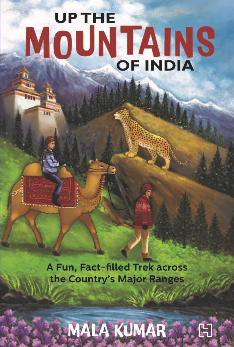
Book: Up The Mountains Of India

Finally it arrived! The author Mala Kumar connected with me a couple of years ago. She was writing a book on the mountains of India aimed primarily at young readers and wanted a geologist to help with fact checking some of the contents. We have had quite a few email exchanges since then, and my curiosity about this book has been growing even since. Mala has written over 40 books for children and this one is sure to enthrall them. But why just children? Anyone interested in India's varied physiography, geology, and wildlife, should read this book. 

I loved the way Mala has used everyday analogies to describe complex geology. One of my favorite examples is using a stuck piano key to explain about fault block mountains. The stuck key is a horst or a block that has moved up relative to the adjacent depressed keys which are called grabens. India's mountains are geological varied. The Himalaya, the Satpura, and the Western Ghats, for example, have formed by very different processes. Mala has used clear language and everyday familiar examples to simplify explanations of their origins. 

But this book is much more than about geology. Forests, wildlife, and human communities living in these rugged provinces really are the heart of the book. There are evocative descriptions of the animal and plant life of the different mountains ranges. Tibetan gazelles and mysterious snow leopards of the Himalaya, hoolock gibbons of the northeastern hills, majestic tigers of the Satpura and the Aravalli, and the bewildering varieties of frogs and reptiles of the Western Ghats, make us proud of our magnificent wildlife. There are lovely photographs scattered through the book. I could not stop gazing at the clouded leopard sitting elegantly on a branch deep in forests of the Mizo Hills. 

People too have lived in these mountains and forests since times immemorial. Their lives and life practices are being threatened as more mountain and forest land is gobbled up for dams, mines and expanding townships. In the northern Aravallis, villagers fought for years to save the sacred grove of Mangar Bani. In the Nallamali hills of Andhra Pradesh, members of the Chenchu tribe along with other organizations protested uranium mining that would have transgressed on the Amrabad Tiger Reserve. The book tells many stories from across the country, from the Aravallis, to the Eastern Ghats, to the Himalaya, of people struggling to conserve forests and water sources. 

Sketches and insets provide a welcome addition to the text. There are fun stories about the people of the mountains, about their crafts, about intrepid explorers, along with short quizzes, crammed in the insets that make the mountains come alive. 

Mountain ranges form the most important watersheds of our big rivers. Today, rampant development of mountain slopes coupled with climate change are becoming big threats to our water security. Mala Kumar's urgent call for conservation and sustainable development emerges again and again throughout the book and she has chosen her audience well. Whom better to inculcate a love and awareness for nature than in our children. These young citizens will be living in an increasingly challenging world and the hope of changing it for the better lies in a deeper understanding of how nature works. 

Go out for a trek in the mountains. Keep a lookout for that bright bluetail, and that curious langur who is peering at you half hidden from behind the thick leaves. Pick up pebbles from the stream bed and ask yourself about its geological secrets. Take a mountain train to the scented Nilgiri heights.  If you are hesitating, this book is an ideal place to begin.

Up the Mountains of India: A Fun, Fact-Filled Trek across the Country's Major Ranges - Mala Kumar. 


Wednesday, April 20, 2022

Kolar Gold Field

Geology and Livelihoods #19

I came across this excellent documentary on the Kolar Gold Field via Twitter. The film is directed by Basav Biradar and produced by Sahapedia.

Email subscribers who are unable to see the embedded video can watch it here- In Search of Gold.


Like many established mining towns, Kolar too saw generations of the same family work in the mines. Son followed father into the dark shafts. Mining provided employment, but it was dangerous back breaking work. The documentary highlights the lives of workers and their struggle for better work conditions. 

Kolar gold is late Archaean in age with mineralization taking place between 2700-2500 million years ago. There are two types of deposits. There is a "stratiform sulphide type", so called because the gold bodies are contained within iron sulphide rich volcanic and sedimentary layers. These deposits formed on the sea floor contemporaneous with volcanism and sedimentation. The second type is a hydrothermal deposit wherein mineralizing fluids mobilized and precipitated gold in veins along N-NE oriented fracture zones. This mineralization event occurred at a later stage when magmatism and metamorphism affected the host terrain.

But do watch this for the many personal stories of the people who worked the mines. 

Tuesday, February 22, 2022

Marking Vindhyan Time

About this time last year I wrote a piece for Nature India on the discovery of the fossil Dickinsonia from the uppermost Vindhyan strata exposed at Bhimbetka caves in Central India. Dickinsonia is considered to be an early animal that lived between 560 to 550 million years ago. This finding seems to confirm an Ediacaran age  (635-541 million years ago) for the youngest Vindhyan strata, termed formally as the Bhander Group. Earlier thinking was that these rocks are 1000 to 900 million years old! 

I have been thinking on and off about this discovery, not as much doubting it as trying to understand its implication from a different angle, that of the ways in which sediments accumulate in a basin and how the passage of time is recorded in sedimentary successions. 

The sedimentary rocks of the Vindhyan Basin have been subdivided by field geologists into four units based on characteristic sediment associations. From the oldest to the youngest, these are, the Semri Group, the Kaimur Group, the Rewa Group, and the Bhander Group.  Deposition of the Semri sediments began around 1700 million years ago and ended by 1600 million or so. Tectonic movements then uplifted, tilted, and eroded these rocks. Between 1200 million and 1100 million years ago the basin floor subsided and new sediment was deposited on the inclined layers of the Semri Group. There is thus a marked  'angular unconformity' between Semri and the overlying Kaimur strata, marking two distinct phases of basin history separated by 400 million years.

The age of Kaimur, Rewa and Bhander Groups, which are often referred to as the Upper Vindhyans, has been more difficult to pin down due to a lack of reliable radiogenic dating and age diagnostic biota. Despite this, a combination of magnetic properties, a few Uranium series dates from limestones, and the age ranges from zircon found in Bhander sandstones,  hinted that the youngest Vindhyan sediments are about 900 million years old.

The fossil Dickinsonia has upended this assumption and appears to have expanded the life of the Vindhyan Basin by a whopping 350-400 million years. This revision has been bolstered by two other age criteria. Microbial fossils typical of the Ediacaran Period have been reported from the Bhander. And secondly, in the year 2020, a detrital zircon dated to 548 million years ago was recovered from the Bhander. Zircons form in magmas or during high temperature metamorphic reactions. The mineral is then eroded away from these source rocks and deposited as a sedimentary particle in adjacent basins. The youngest zircon population in a sedimentary layer sets its maximum age,  since the strata cannot be older than the detritus it is made up of. It could be much younger than the contained zircon, but in this case a lack of Cambrian fossils has constrained the age of the Bhander to be older than 541 million years ago.

Let me now dive in to what has been pricking my geological curiosity. The Kaimur, Rewa and the Bhander are thought to be three distinct episodes of sedimentation. Stratigraphers may recognize them as 'depositional sequences' formed when accommodation space for sediment to accumulate is being created either by the basin floor sinking due to tectonic movements or due to eustatic (global) sea level changes. 

Such depositional sequences are building blocks of sedimentary successions in basins of all ages, each episode lasting at most few tens of million of years. V.S. Kale in a discussion note on Indian Purana basins points out that the physical characters of the sediments are not suggestive of slow sedimentation rates, and given their thickness, estimates that these sequences span 10-20 million years each. Even assigning the upper limit, Kaimur, Rewa and Bhander were deposited in about 60 million years or so. If Upper Vindhyan sedimentation began around 1200 -1100 million years ago and ended by 550-540 million years ago, that leaves about 550 million years of unrecorded elapsed time.

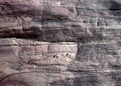
Sedimentation is an inherently episodic process with periods of non-deposition alternating with sediment accumulation. See this close up of an outcrop of a cross bedded sandstone from the Badami area in Karnataka.  


These sediments were deposited in a long lasting river system. Surfaces that result from non-deposition are marked as S1, S2.  In this hierarchical scheme, S1 spans perhaps a few minutes to a few hours and is a break in deposition on the lee side of  migrating ripples due to fluctuations in current energy. The S2 surface has developed over the channel sand body and spans months to years and represents seasonal fluctuations in currents or even a long drought which dries up the channel. 

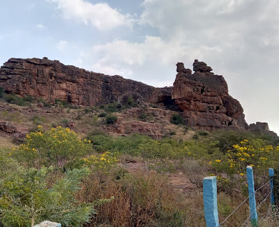
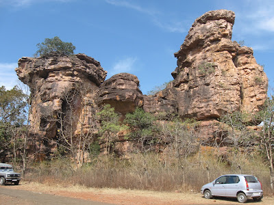
 Now, cast  your eye on this larger outcrop of the Badami sandstone. 

 
It has formed by the stacking of smaller sandstone units, each containing several surfaces of non deposition. The higher order surface S3 in this thicker pile marks a longer period of non-deposition and indicates a shift in course of the river channel. Hundreds, even thousands of years will pass, before the channel migrates back to its original location and deposition resumes at that locale.

Although I may be amiss in my specific interpretation of these surfaces of non-deposition, what I want to convey is that sediment deposition in all types of environments is interrupted by periods of non-deposition ranging from a few minutes, to thousands, even millions of years. The vast majority of elapsed time a sedimentary succession represents may be accounted for by periods of non-deposition and erosion. 

The Kaimur, Rewa and Bhander collectively account for a 60 million year time-span. If the revised age range for the Upper Vindhyans is correct then there were gaps of hundreds of millions of  years between the deposition of these Groups.

But these very long breaks invariably result due to tectonic uplift and cause pronounced erosion and chemical alteration of the exposed sedimentary surface. In outcrop it is recognizable as an undulating surface with the debris of weathering consolidated into hard soils, and in the formation of solution pits in limestone terrains. Such basin wide surfaces of marked erosion have not been found separating the Kaimur and the Rewa, and between the Rewa and the Bhander strata. 

Smaller breaks though do occur. Chandan Chakraborty in a study of sedimentary cycles of the Vindhyan Basin finds an angular discordance between the Kaimur and the Rewa, and the Rewa and the Bhander. However, this is restricted only to the south of the Vindhyan Basin. The discordance between the older and younger sequences dies out towards the north. This stratigraphic relationship  suggests that the tectonic movements were contemporaneous with sedimentation. The basin floor was tilted up on one side interrupting sedimentation and eroding the exposed strata there, while at the other end (north), subsidence and deposition continued. The periods of non-deposition and erosion between these sequences was a more localized event, lasting few millions of years at most. The kind of tectonic upheavals that may halt deposition for hundreds of millions of years across the entire basin are simply not attested to in the stratigraphic record of the Upper Vindhyans. 

It seems to me, and I say this mischievously, that the earlier estimate of 1000-900 million year age of the uppermost Bhander strata and for the end of Vindhyan sedimentation sounds quite reasonable! 

How secure is the finding of Dickinsonia and the assigned Ediacaran age of the Bhander Group? I am in no way trying to rebut this finding. The microbial fossil Arumberia found in the Bhander is considered by experts to be a reliable Late Ediacaran age indicator. However, the identification of Dickinsonia is based on a 3D digital reconstruction of photographs taken at the site of discovery. Due to the protected status of the Bhimbetka Caves, the scientists were unable to excavate the impression and subject it to a physical examination or a chemical test for organic residue. This is the only report of Dickinsonia from the entire Vindhyan Basin.

The young 548 million year date of the detrital zircon is based on one grain. The researchers are confident of their analysis and see no reason to reject this data point, though they admit that further corroboration of this date will be necessary given that previous studies did not report such young zircons from the Bhander strata. Curiously, no source terrain of this young zircon is identified in the paper.  

The news about Dickinsonia received wide coverage in India. That was expected given the long standing uncertainty of the age of the Vindhyans and the importance of the fossil for understanding early animal evolution and Ediacaran ecology and paleogeography.  But these new proposed timelines have thrown up a puzzle about rates of accumulation of sedimentary sequences and magnitudes of intervening breaks. We are quick to appreciate changes in sedimentary layer color, their structures, and their geometry, and interpret these changes in the context of fluctuating depositional conditions. But what about surfaces of non-deposition? Do they have anything valuable to contribute to our understanding of geological processes. 

The paleontologists Niles Eldredge and Stephen Jay Gould once perceptively observed that 'stasis is data'. The unchanging morphology of many fossil species lineages tell us something about the mode and tempo of evolution. Geological surfaces of stasis, when sedimentation has come to a standstill, are richly informative too in their own way. Surfaces representing very long time-spans may develop during convulsions in the earth's crust and periods of mountain building. The soils that often mantle such surfaces archive information about past climate and terrestrial life. Breaks of smaller and smaller time-spans like wise have a variety of drivers such as orbital control on climate and sea level, migration of depositional environments, and even tidal cycles.  

How many more hiatuses of unknown duration lie hidden within the Vindhyan sediment pile?  They may mark phases when no sediment accumulated but they are as much an integral part of basin history as are the iconic sandstone faces of Bhimbetka.


Saturday, September 25, 2021

LiveHistory India Videos: I Speak About Deccan Volcanism

LiveHistory India has started a wonderful outreach initiative, highlighting India's geological heritage. They invited me to talk about Deccan Volcanism. I spoke about how it all began, the physiography, places of interest, and the fossil bearing intertrappean sediments and their value in understanding ecology and broader patterns of extinction and recovery spanning the mass extinction that occured 66 million years ago. 

This was recorded a couple of weeks ago, and it is now online. The original recording was about 40 minutes, but it has been edited and the video is 17 minutes long. Subtitles are in Hindi.

Permanent Link- Deccan Volcanism And Its Various Aspects


LiveHistory has put out more such videos with other Indian geologists. 

1) India's Fossil Heritage- Dr. Sunil Bajpai

2) Markers of Earth's Formation in India- Dr. Pushpendra Ranawat

3) A Panel on Geological Heritage of India- Dr. Pushpendra Ranawat, Bidisha Bayan, Dr. Reddy, and Aliya Babi

Hope you enjoy my talk!

Sunday, January 31, 2021

Mammalian Evolution, Earth Biosphere, India Geology Outreach

 Sharing these interesting items:

1) Simone Hoffman writes about one of the fundamental transitions in mammalian evolution, the transformation of bones of the lower jaw into those of the middle ear.

Lend an ear to a classic tale of mammalian evolution.

2) How has the earth's evolving biosphere from early microbes to megascopic land plants impacted the biogeochemistry of the earth? A great review article by Noah Planavsky and colleagues. Read this one quickly. It is open access for now, but might go behind a paywall in the next few weeks.

Evolution of the structure and impact of Earth’s biosphere.

3) Live History India anchored by Mini Menon has produced a great geology outreach video. Four geology enthusiasts talk about India's varied geology, how to raise awareness among our citizenry about the importance of geology in our lives, and the urgent need to protect sites of exceptional geological significance. Dr. Pushpendra Ranawat, Bidisha Bayan, Dr. Reddy, and Aliya Babi are the guests. 

Do make the time and watch this. Email subscribers who can't see the embedded video can watch it here - India: What Lies Beneath.


Wednesday, January 27, 2021

Fossil Dickinsonia Indicates Ediacaran Age For Upper Vindhyans

 It looks like one of the long running debates in Indian stratigraphy has been resolved. 

The Vindhyan Basin is one of several Proterozoic age basins in Peninsular India. The youngest rocks in this basin have been accepted to be of Neoproterozoic age i.e. less than 1 billion years old. But absolute dating of these rocks is tough. Criteria like youngest detrital zircon ages, which tell us the age of the youngest source rocks from which sediments were derived, were hinting at an age of about 850- 900 million years for the uppermost Vindhyan strata. On the other hand, presence of fossils like Arumberia and Beltanelliformis minuta, both considered microbial organisms, were suggesting of an Ediacaran age (637-541 million years) for youngest Vindhyan rock units, although there wasn't a widespread acceptance of these dates. Then, last year, a paper by Lan and colleagues published new detrital zircon dates of 548 million years from the Maihar Sandstone. They indicated that the uppermost Vindhyans are late Ediacaran in age. Detrital zircon age tells us that the sediment cannot be older than the zircon, i.e. it gives a maximum age for the deposition of the sedimentary layer.

Now, a stunning fossil find seems to confirm this chronology. The Ediacaran age fossil Dickinsonia has been dated to about 555 million years from sites in Russia. This fossil was found as impressions on Maihar Sandstone at the site of Bhimbetka in Madhya Pradesh. Bhimbetka caves are famous for pre-historic cave art. Gregory Rettalack and colleagues report Dickinsonia, in their own words.. " hiding in plain sight, on the roof of the Audi-torium Cave (N22.938402° E77.613504°), the first of several Paleolithic and Mesolithic cave painting and petroglyph sites on the path into Bhimbetka Rock Shelters"..

The fossils remain in place at the site as negative relief impressions and has been documented photographically (pics below).


            Source: Retallack G. et.al., 2021: Dickinsonia discovered in India and late Ediacaran biogeography.

The biological affinity of Dickinsonia is contested. Some paleobiologists think it is a representative of an extinct group of early animals. Others think it is likely to be a macro algae. No unequivocal indicators of animal life, either in the form of body or trace fossils, has been found in the Vindhyan Basin so far. Such a recent age for the uppermost Vindhyan strata may renew hope that the earliest stages of animal evolution are preserved in these rocks. 

I had written a long post on the age problem of the upper Vindhyans some time back. In that I had mentioned that physical signals like magnetic signatures and chemical criteria like carbon isotope trends were suggestive of the uppermost Vindhyans being not much younger than 850 million years. But similar magnetic signals and carbon isotope trends may be repeatedly produced under similar physical and chemical conditions.

Fossils are a better guide to age. Evolution produces unique life forms. Species exist over a restricted time range. This is the basis for constructing a relative time scale for global strata. Presence of the same species or same group of organisms in physically disconnected rocks indicate contemporaneity of these units. To ascertain their absolute age they need to be dated using one or more of radiogenic dating methods, usually relying on interlayered volcanic ash which contains the  appropriate minerals. Or, as in this case, using detrital zircon, which gives us the maximum age of the unit.  Global surveys of late Neoproterozoic strata show that Dickinsonia is not found in rocks younger than about 550 million years. This brackets the age range of the Dickinsonia containing unit of the Maihar Sandstone at Bhimbetka to between 555 -550 million years. Detrital zircon ages of 548 million years for Maihar Sandstone indicate that Vindhyan sedimentation continued for some time after.

I find myself compelled to ask one question here. What is the source of the 548 million year old zircons reported from the Maihar Sandstone? I haven't read Lan et. al.'s paper, so I am guessing. The age of the youngest zircons from the Aravalli and Central Indian terrains which were the main source of sediments supplied to the Vindhyan Basin are about 800- 900 million years. The Bastar region could be one source for these even younger zircons. High grade gneiss and granitoids from this craton have yielded 500 million year old zircons likely produced during the collision of the Eastern Ghat terrain with the eastern margin of India. Or perhaps they were sourced from terrains which are now far far way in Antarctica.

There are other Proterozoic basins in Peninsular India where age uncertainties of especially the uppermost units continue to be the subject of lively debate. This fossil find might just inspire geologists to start a fresh search for hitherto elusive age indicators.