These two books came highly recommended via friends and social media.


These two books came highly recommended via friends and social media.
One of my favorite courses during graduate work in Pune was geological Remote Sensing. We focused a lot on visual interpretation of aerial photographs and satellite imagery. Lab work meant hours of poring over different areas of India and making preliminary geology maps based on observations of the landforms and rock structures visible from space. The rock composition, structure, and weathering patterns controls the surface expression of geological units. These are manifest on satellite imagery and on aerial photographs as differences in tone, texture, structural styles, and relief.
I came across a nice example of the juxtaposition of two distinct geologic rock units just northeast of the town of Sirohi in Rajasthan.

These two terrains made up of the Erinpura Granite and the Sirohi Group sediments are easily recognizable.
The terrain west of the yellow line and isolated ribbons between the purple lines is made up of layered metamorphosed sedimentary rocks of the Sirohi Group. These sediments were deposited on the Erinpura Granite basement around 850 million years ago. Hard rock layers form northeast southwest oriented ridges with intervening valleys underlain by a softer lithology. The texture appears fine and the ridge and valley terrain has a substantial vegetation cover. The rock layers can be traced as a series of folds. The Sirohi Group sediments were deformed and metamorphosed by 820 million years ago.
The Erinpura Granite represents magmatism that occurred around 900 million years ago. Occurring mostly east of the yellow line, the granite also forms enclaves (orange outline) in the fold belt.
The granite appears as a light toned surface. It is massive body of rock, lacking the layering seen in the western sedimentary basin. The landform is a low elevation plain as compared to the Sirohi rocks.The rock has a coarse granular texture. Its surface has scant vegetation. Several lineaments (dark colored lines) are seen crisscrossing the granite body. These are fractures and dikes. Shrubs and trees growing along the fractures and dikes give them a darker appearance and make them stand out against the lighter granite body. The fracture sets have also controlled the local drainage. Several streams can be seen flowing along straight courses.
Below are two close up images of the contact zones between the two terrains.

At this scale you can appreciate why the granite as a coarser texture in the synoptic imagery. The fracture systems has broken the granite in to a blocky surface.
In this image below the Erinpura Granite occurs as an enclave surrounded by Sirohi metasedimentary rocks.


Geology mapping done. Now to visit Rajasthan for a field check!
A couple of weeks ago Iceland awaited with much anxiety as magma made its way to the surface. A volcanic eruption seemed imminent. That danger seems to have passed for now. Seismicity has abated and magma may not break through and erupt.
Misunderstandings regarding climate change though shows no signs of receding as this comment shows -

Source: X - https://twitter.com/dremtee/status/1723427183182446871
Ever so often it is worth putting up the numbers:
Anthropogenic CO2 emissions - About 40-50 billion tons per year.
Volcanic CO2 emissions - Approximately 500 million tons per year.
Terry Gerlach of the U.S. Geological Survey has compiled global data on volcanic emissions - Volcanic Versus Anthropogenic Carbon Dioxide, published in EOS Transactions American Geophysical Union.
This article is from 2011, but there are good explanations on volcanic emission rates and the observed discrepancy (which has increased in the 12 years since publication) between anthropogenic and volcanic emissions.
What conditions limit volcanic CO2 emissions on present day earth?
On average, magma contains about 1.5 weight percent dissolved CO2. Estimated annual magma production on earth amounting to about 80 billion tons won't create near enough volcanic CO2 to match human emissions. About 850 cubic kilometers of magma would be needed to be generated annually to create volcanic CO2 on an anthropogenic scale. So much magma production either under land or sea would not have gone unnoticed.
Short lived volcanic eruptions like past events in Iceland, or Mt. Pinatubo, or Mt. St Helen's, although violent and spectacular, didn't emit more than a few million tons of CO2. These amounts are too small to have a discernible warming effect. Large explosive eruptions in fact might cool the earth by a degree or so for a short time because the sulphur particles they emit reflect sunlight back in to space.
Can volcanism cause global warming? Yes, but over much longer time scales.
Weathering of surface silicate rocks consumes about 500 -700 million tons of CO2 per year, offsetting the amount emitted by volcanoes. There has to be sustained volcanism at high emission rates for decades to hundreds of years to create an imbalance between weathering and volcanism and change climate.
Cin-Ty Lee and Slyvia Dee 's commentary on this subject explores the role of volcanism on global climate.
So near Pune, yet I had never been to this location near Bhor.

It is popularly known as necklace point. The river Nira loops its way through the countryside forming a series of lovely meanders. A high point overlooking the valley allows a clear view of this feature.
I was on a drive with some friends, spending the day exploring the back waters of the Bhatgar and Nira Deogarh dams. We eventually reached Warandha Ghat, one of the spectacular passes linking the Deccan Plateau with the western coastal plain.
At the edge of the plateau, high relief exposes sheer rock faces.
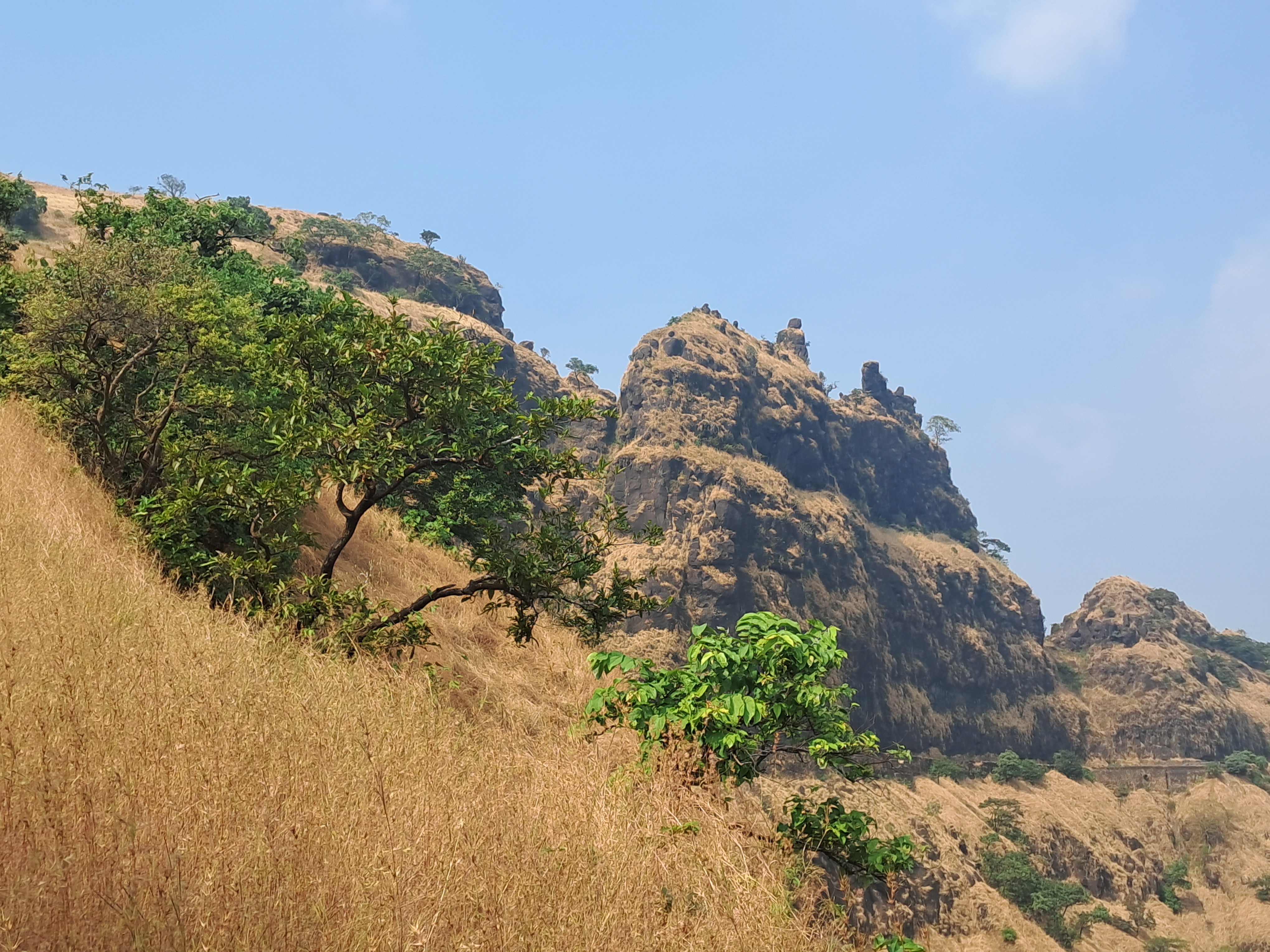
The grand scale of Deccan Volcanism is manifest so clearly in the lava flows traceable over hundreds of meters despite the afternoon haze.

On a satellite image, X marks the view point looking south towards the big meander.

This is a beautiful area near Pune to spend a day out.
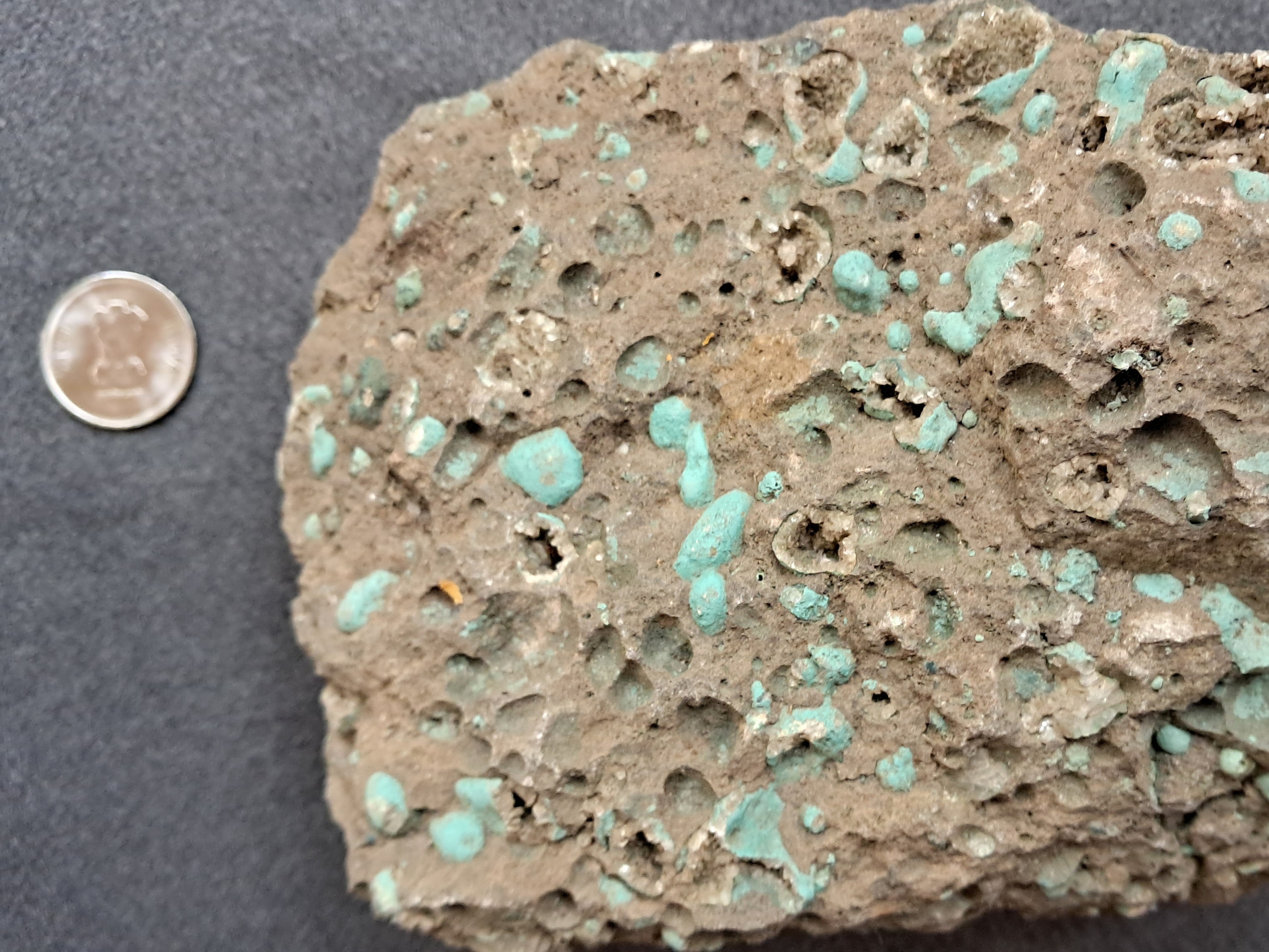
I came across this stunning image of a mineral filled vesicle on the September 2023 cover of Geology. The rock sample was collected from the Louisville Seamount Chain in SW Pacific Ocean.

Source: Elmar Albers et.al. 2023- Timing of carbon uptake by oceanic crust determined by rock reactivity.
Vesicles in igneous rocks are spherical holes formed by expanding gas bubbles. As lava erupts, dissolved gases bubble out. Lava solidifies fairly rapidly on exposure either to air or water. The bubble shape is retained as a small cavity. It gets filled with minerals when magmatic fluids and mineral saturated seawater or groundwater circulate and react with the rock.
The basalt rock in this study is about 50-74 million years old. The calcite in the vesicle precipitated within 8 million years of eruption. Alteration of undersea basalt is a CO2 sink. Basalt reacts with seawater, trapping carbon in carbonate minerals. The calcium required for formation of carbonate minerals is provided by the alteration of minerals like plagioclase. The study is trying to estimate how long such carbonation reactions continue. Carbonated oceanic crust eventually sinks into the mantle at subduction zones sequestering carbon from the surface for hundreds of millions of years.
This particular vesicle is filled with carbonate (calcite) and clay. Notice the beautiful banding suggestive of pulses of mineral formation. Among the brown and white layers are white bands of faceted saw tooth calcite. And the upper part of the vesicle is filled with large irregular shaped crystals. Surrounding the vesicle is the 'groundmass', made up of tiny crystals of plagioclase feldspar, iron oxide, and volcanic glass. There is no scale in the picture, but my guess is that the vesicle is a few hundred microns across.
In a hand sample a vesicular basalt will look like the example below. This is from the Deccan Traps near Pune.
The vesicles here are much larger than the first example. Many are empty. Some vesicles have a lining of tiny crystals. Carbonation of terrestrial basalts also constitutes a carbon sink. Combating global warming and achieving net zero emissions will require, foremost, a steep reduction in emissions, but additionally also removing carbon dioxide from the atmosphere and safely storing it in long term reservoirs. Such carbon removal and sequestration projects are exploring the potential of basalts and related igneous rocks as a long term carbon sink.
Readings over the past few weeks.
1) Taking the First Steps Into a Newly Formed Volcanic Underworld: Maya Wei- Haas describes a fascinating landscape on the Canary Islands in the Atlantic Ocean. Volcanic eruptions and the transport of lava via underground tubes has formed a subterranean world of stacked lava tunnels and caves. Their mapping is ongoing and scientists hope to understand not just the details of volcanism and the hazards it poses, but also how life can colonize such nascent surfaces, powered by nutrients from minerals. As one of the scientists remarks- "lava tubes is a rare chance to watch an evolving ecosystem from time zero".
2) It looks like the 23ky old human footprints at White Sands are solid: What is the earliest securely dated evidence of people in the America's? In 2021, there was a report of human footprints from an ancient lake in New Mexico. Since the footprints themselves could not be dated, seeds of an aquatic plant that were found in the same layer were carbon dated to about 23 thousand years ago. That result was greeted with caution. The main concern was that the seeds may have taken up much older lake water containing less of the radioactive isotope C14. This may have made the dated material look older than it actually was.
Now, there has been more work on the geochronology of the site using two more independent lines of dating. The results agree with the previously estimated date of 23 thousand years. ArcheoThoughts summarizes the dating methodologies.
3) Discovery of oldest 3D-preserved microorganisms: Before organisms evolved the ability to build hard skeletons, their remains have been preserved as impressions on soft sediment or as chemical degradation products recognizable by a light carbon isotope signal. Stefanie Terp reports on a discovery of 3D preservation of microorganisms from a mine in Ukraine. They are 1.5 billion years old!
Scanning Electron Microscopy reveals the filamentous structure of these creatures. They are most likely a variety of fungi. Groundwater in the granite environment in which they lived was saturated with aluminum and silica. The microorganisms were covered and entombed in micrometer thin layers of aluminum silicate, perfectly preserving their delicate structure.
A reader sent me this photograph of a pebble he had collected from a stream bed near Belgaum, Karnataka.

Photo credit: Gopisundar
These look to me like iron rich pisolites. These spheroidal grains form by the accretion of iron, manganese, and aluminum hydroxides around a nucleus. The core may be an aggregate of soil particles, a rock fragment, or even wood debris.
You will notice that the core is quite massive and structureless but in a few grains a crude concentric layering is seen at the margins. The pisolites are bound together into a firm mass by mixture of clay and iron aluminum hydroxide. Pisolites form during prolonged episodes of chemical weathering of rocks like basalt or shale or iron aluminum rich metamorphic rocks. They are present in thick laterite and bauxite profiles.
The picture below is a representative example of pisolite from a location in Brazil. It shows the occurrence of pisolite layers in a weathered soil profile, along with a hand sample and a cross section under high magnification.

Source: K Marques et.al. 2022: Geochronology (preprint).
Here is a map of the landscape just south of Belgaum that I am describing in this post.

Source: Amanda Jean et.al 2020: Journal of Geological Society
It shows the distribution of three distinct horizons of chemically weathered soil, named as the S1, S2 and S3 surfaces. Each of these horizons consist of tens of meters of laterite or bauxite and manganese rich ore. There has been some recent success in dating these weathered layers using the mineral crytomelane, a potassium rich manganese oxide. Three distinct weathering periods are documented. As India broke away from Gondwanaland it eventually drifted northwards into tropical climatic belts. Throughout the Eocene to Miocene, long phases of hot humid climate resulted in intense chemical alteration of the Western Ghat landscape.
The oldest soil, surface S1 in the map, formed between 53-44 million years ago. Surface S2 formed later in the Oligocene-Miocene between 39-22 million years ago. And surface S3 developed in the mid Miocene, between 14-10 million years ago.
The graphic below tells a story of landscape evolution recorded in the formation of these three weathering profiles.

Source: Amanda Jean et.al 2020: Journal of Geological Society
Episodic dissection of a plateau through the Cenozoic kept stripping away rock layers, and younger bauxite and manganese rich soils formed at lower altitudes on freshly exposed rock and debris flows. The youngest surface S3 has developed on a pediment. These are layers of debris eroded from surrounding hills that accumulate in low lying areas. Surface S3 indicates a very active phase of weathering and erosion of the surrounding mountains ranges that took place between 22 and 14 million years ago. As a once contiguous plateau was fragmented, older surfaces S1 and S2 remain preserved on isolated mesas and table lands.
The pisolite my friend sent me could have broken off from one of these surfaces. Its hard to say which one. The overall light color suggests that it is aluminum rich, and may have been sourced from the bauxitic S1 or S2. But this is just a guess.
Pebbles from a stream can hold many secrets. Don't just chuck them away :)
No matter how many David Attenborough specials you may watch, nature always throws more surprises at you.
Foraminifera are protists that build a skeleton or a test made up of calcium carbonate. The calcium carbonate is precipitated out of sea water. There is a sub-group of foraminifera which construct a shell not by capturing the calcium carbonate via chemical precipitation, but by assembling sedimentary grains and then cementing them together like a brick and mortar structure. This group of forams are known as agglutinated foraminifers.
All this is well known. Many different species of forams use a variety of grains as bricks. They are mostly different shell fragments, but even mineral grains like ilmenite (iron titanium oxide) , rutile (titanium dioxide), or garnet are used.
Now there is a new report of a deep sea living agglutinated foraminifera which constructs a tube made up of planktonic foraminifera shell fragments of a single species.
Read that again. A benthic (bottom living) foram shell made up of bits of another foram which lived floating in the upper water column!
These shells are selected to the exclusion of all other types of available sedimentary grains. The specimens were recovered in a core drilled off shore northwest Australia by the International Ocean Discovery Program. The paper by Paul N. Pearson and IODP 363 Shipboard Scientific Party is published in the Journal of Micropalaeontology.
Here is the entire abstract. It is mind boggling.
Agglutinated foraminifera are marine protists that show apparently complex behaviour in constructing their shells, involving selecting suitable sedimentary grains from their environment, manipulating them in three dimensions, and cementing them precisely into position. Here we illustrate a striking and previously undescribed example of complex organisation in fragments of a tube-like foraminifer (questionably assigned to Rhabdammina) from 1466 m water depth on the northwest Australian margin. The tube is constructed from well-cemented siliciclastic grains which form a matrix into which hundreds of planktonic foraminifer shells are regularly spaced in apparently helical bands. These shells are of a single species, Turborotalita clarkei, which has been selected to the exclusion of all other bioclasts. The majority of shells are set horizontally in the matrix with the umbilical side upward. This mode of construction, as is the case with other agglutinated tests, seems to require either an extraordinarily selective trial-and-error process at the site of cementation or an active sensory and decision-making system within the cell.

The photographs from the paper shows the tube of the agglutinated foraminifera made up of planktonic foraminifera shells of a single species.
Charles Darwin knew of agglutinated foraminifera from reports he had read and was astonished....“almost the most wonderful fact I ever heard of. One cannot believe that they have mental power enough to do so, and how any structure or kind of viscidity can lead to this result passes all understanding”. This was a letter he wrote to W.B Carpenter who had described them in 1873.
I'll leave you to ponder upon this most exquisite of natural wonders. The paper is open access: A deep-sea agglutinated foraminifer tube constructed with planktonic foraminifer shells of a single species.
My latest set of readings.
1) Why Darwin Admired the Humble Earthworm. A delightful essay by Philip Ball on Darwin's work on earthworms. Published towards the end of his career, this book apparently sold more copies than the Origin of Species! As Philip Ball wittily observes, that tells us something about the English passion for gardening. Darwin's research on earthworms consisted of detailed observations and cleverly designed experiments, often carried out with the help of family members.
His powers of observation and analysis remained undimmed - "Darwin reported that 80 percent of leaves he removed from worm burrows had been inserted tip first—a far from random distribution".
2) No, the Gulf Stream isn't going to shut down. The premise of the movie The Day After Tomorrow is that of a catastrophic cold snap engulfing north America and Europe, triggered by the shutting down of the Gulf Stream. This massive ocean current forms in the subtropics in the western side of the Atlantic and transports heat from the lower latitudes to northern Europe, moderating the temperatures in these northern regions. Media reports claim that recent work might be pointing to a collapse of the Gulf Stream, but as Frank Jacobs explains, people are conflating two very different current systems.
Some studies are suggesting that the Atlantic Meridional Overturning Circulation, a much smaller and restricted circulation system, might be slowing down and might even collapse by 2050. This will result in some cooling in the Greenland and Norwegian seas, but will not affect the larger Gulf Stream. The article has a nice animation of global ocean currents which I found informative.
3) They Have Put Geology in Coffins. For long, geologists have been complaining about the utter indifference shown by successive Indian governments to our natural heritage. Here is one more example from Himachal Pradesh. Along the Kalka-Shimla highway, on the stretch between Parwanoo and Solan lay a treasure. This was a section of sedimentary rocks recording the retreat of the Tethys Sea which began after the collision between India and Asia started creating high topography. Along this stratigraphic section, marine sediments give way to freshwater deposits. The outcrop was a natural outdoor laboratory for students and researchers. Now it is gone. The National Highway Authorities of India has covered it with concrete and stone walls. Science is the big loser again.
Arundeep Ahluwalia expresses the anguish of geologists who knew and loved this part of the Himalaya- "It forever denies coming generations any chance to study the long stretches of such highways and to the nature lovers in society the excitement of the history and grandeur of the earth".
Read and weep.
Boudinage is a structure that is developed when rock layers are being pulled and stretched. The term is derived from the French word for sausage. A rock layer is deformed by necking and is segmented into a string of sausages. The structure is best developed when there is contrast in competence or strength in a rock pile. The stronger layer is broken up in boudins, while the weaker layer 'flows' around and fills the gaps created in the neighboring boudin layer.
I wanted to showcase examples of boudins from igneous, sedimentary, and metamorphic rocks.
The first example has been recently documented in a paper on silica rich magmatism from Sausrashtra by Anmol Naik and colleagues. The photograph shows a rhyolite with boudinage (black arrow) developed in a lava flow band. This deformation is due to layer parallel stretching during flow of a viscous lava.

Source: Anmol Naik et.al. Geological Magazine 2023
The second instance is from Darma Valley, Kumaon, near the village of Philum, not so far from the Panchachuli Glacier. It is a remarkable instance of boudins developing in a sandstone. Black arrows highlight elliptical and oval knobs, fragments of a once continuous sand rich layer. Notice how the surrounding thinly layered material has flown into the gaps between these boudins. The more competent sand layer broke up, while the softer clay rich material got wrinkled and warped but did not break.

And lastly, here is an example of the more common variety of boudinage encountered in the field. This has developed in a high grade metamorphic rock. The lighter more competent layer made up of quartz and feldspar has been deformed into a series of boudins, while the mica rich grey layers are ductile. This outcrop is also from Darma Valley, Kumaon, near the village of Baaling.

The three examples showcase deformation which produced similar structures in very different settings. Internal forces generated during flow of a viscous lava can result in folding and boudins. In sedimentary basins, similar forces may affect a sand rich slurry moving down slope as a gravity flow or on semi consolidated sediment shaken during an earthquake. And forces acting on high grade metamorphic rocks produce some spectacular boudins at high temperatures during episodes of mountain building.
Documenting rock deformation in the field is fun!
My friend Bhushan Panse, who is a geology enthusiast and an avid rock and mineral collector, handed this specimen to me over a coffee meeting. He had bought it from a mineral supplier from Khambhat, Gujarat.

I commented that it is a septarian concretion. These hard ellipsoidal or oval shaped lumps form in mud and silt layers by the precipitation of calcite around a nucleus. Khambhat and many other parts of Gujarat are underlain by Mesozoic and Cenozoic age sedimentary rocks. The process of concretion formation would have taken place at shallow burial depths when these sediments were still porous and water saturated. Mineral deposition in pore spaces often takes place in concentric layers. The calcium carbonate comes from saturated marine pore water or is derived from shells as they start dissolving during shallow burial. Notice the rust to brown color of the concretion. It is likely due to the presence of iron oxide and hydroxides which formed in the pore spaces from the iron contained in clay minerals.
The term Septarian Concretion refers to the radiating cracks or Septaria (derived from Septum). Cracks come in a variety of shapes. There are radiating cracks as seen in this specimen. These cracks are wider near the center and taper outwards. Other concretions may show concentrically oriented cracks, or overlapping sigmoidal shapes. Cracks may intersect, pointing to multiple cracking events. They are filled with either calcite or silica. The crystals filling these cracks are sometimes broken and displaced, and cracks may contain mud and silt. These features indicate a variety of stresses at play in concretions interiors.
There are many ideas on how these cracks form. They have been interpreted as shrinkage cracks due to desiccation and hardening of mud. Dehydration during chemical transformation of clay minerals is another explanation. A third hypothesis links the formation of cracks to gas expansion released during putrefaction of organic material.
Sedimentologist Brian Pratt has offered another novel explanation. He proposed that these cracks result due to shaking of sediment during synsedimentary earthquakes. Shaking during ground motion results in variable stress fields in the interior of the concretion forming a large variety of crack geometries. These concretions may be preserving signals of seismicity affecting that sedimentary basin!
Here is his compilation of the large variation in septarian concretion cracks from various sedimentary basins across Canada.

Source: B. Pratt: Septarian concretions: internal cracking caused by synsedimentary earthquakes
A geologist friend who worked with the Geological Survey of India suggested another intriguing explanation. Parts of the region near Khambhat experienced explosive volcanic activity towards the waning phases of Deccan Volcanism. Ash expelled from volcanoes can coat small broken lava fragments forming lumps known as 'áccretionary lapilli'. Aggregations of ash and pyroclastic material if larger than 64 mm are known as volcanic bombs. This concretion fits the size range of a bomb. The dark fragments in the center of the concretion do resemble a fine grained igneous rock. A closer examination under a microscope is needed for a confirmation of its origin.
It is fun to examine hand specimens that friends collect from various part of the world and try to identify the rocks and minerals. But often a clear cut answer is not possible due to the need for additional information from a higher resolution or the chemical makeup. But a guessing game over coffee is always welcome.
Geodes, nodules, and concretions found in volcanic and sedimentary rocks are mystery objects. You never know what you will see inside when you break open one of these lumps. There may be an array of perfectly faceted purple amethyst crystals and multicolored calcite. Or a trapped fossil. Or a crack network filled with bright and shiny calcite and quartz. These crystal rich interiors give us important information on the composition of fluids which react with rock at many different times during their geologic history. This water rock interaction is of interest to mineralogists and economic geologists who want to understand the history of fluid flow through sedimentary basins and the conditions that lead to the concentration and deposition of metals.
Geological investigation at all scales inform us about how the earth works. One can stand and gape at great mountain ranges and wonder about the movement of tectonic plates. But you can also crack open a rather dull colored lump from a shale and marvel at its insides, all telling a story of groundwater flow and chemical reactions, and who knows, past earthquakes as well.
Some interesting readings over the past couple of weeks.
1) In a Fierce Desert, Microbe ‘Crusts’ Show How Life Tamed the Land. Zack Savitsky describes a fascinating research program underway to study microbial life in the fierce Atacama Desert in Chile. These organic communities are called 'grit crust'. They coat pebbles and large sand grains on the desert floor. A closer examination has showed that they are composed of hundreds of species of cyanobacteria, algae, fungi, along with lichen combinations. These microbes play an important role in the biogeochemical fixation and cycling of elements and over millennia break down rock and enrich the soil in nutrients. They also give scientists a glimpse on how life may have first colonized land, perhaps as early as the Archean.
2) Digging into India’s critical minerals dash. Recently, the Indian Ministry of Mines released the Critical Minerals for India report. India has also approved commercial mining for minerals containing the following elements —lithium, beryllium, titanium, niobium, tantalum and zirconium. These elements are raw materials for magnets used in wind turbines and EV motors. M Rajshekhar writes about the geological distribution of these elements and global supply chains, pointing out the challenges India faces in procuring a reliable supply of these materials necessary for its energy transition away from fossil fuels.
3) Explainer: Will global warming ‘stop’ as soon as net-zero emissions are reached? Even if we stop emitting CO2 today, we are locked into hundreds of years of warming because of past emissions. I too have uttered these words, but it turns out that I, and many others, have been conflating two separate scenarios: constant concentrations versus zero emissions. Zeke Hausfather clarifies what these two different situations mean and how they will differently impact CO2 levels and future warming.
Net zero CO2 scenario will very quickly stabilize temperatures or even slightly cool the earth, but that will also depend on emissions of other confounding variables like aerosols and other greenhouse gases. Aerosols by blocking sun's energy
have a cooling effect. On the other hand, achieving net zero too far in the future might still result in warming due to the feedback effects of other greenhouse gases like methane and nitrous
oxide. Good explainer!
The International Commission of Stratigraphy has published an updated chronostratigraphic chart.

You can download a high resolution pdf as well as a jpg version.
This is a good resource if you want to know the time spans for all those hard to pronounce units that geologists keep referring to in their talks and articles.
The columns in the figure are hierarchical divisions of geologic time based on the rock record. Take for example the columns on the extreme right. Proterozoic Eon is an interval of time defined by rocks that formed between 2.5 billion years ago and ~539 million years ago. The Neoproterozoic Era is a subdivision defined by rocks formed between 1 billion years ago and ~539 million years ago. And the Ediacaran Period is a time unit represented by rocks formed between 635 million and ~539 million years ago. A significant change occurred around 539 million years ago. Shelly fossils began appearing in the rock record. This marks the end of the Proterozoic and the beginning of the Cambrian Period.
Notice something interesting?
Take a look at the internal divisions of the Archean and the Proterozoic Eons. The Archean is divided into fairly uniform 400-300 million years units, while most of the Proterozoic is divided into roughly 200 million years units.
In contrast, the Phanerozoic Eon subdivisions have unequal age spans. By around 550 million years ago, unicellular and multicellular creatures evolved the ability to build hard skeletons made up of calcium carbonate, calcium phosphate, and silica. This resulted in better preservation of their remains in the rock, giving geologists the ability to track evolutionary changes. The boundary between different subdivisions you see on that chart is a recognition of the appearance of a new species or species assemblage. Evolution's clock has an irregular beat, making for unequal chrono units.
More uncommonly, boundaries are defined by chemical shifts that mark a change in the earth's environment. For example, the newest subdivision of the Quaternary Period, the Meghalaya Age, is recognized by shifts in the oxygen isotope composition of stalactites from a cave in Meghalaya, signalling global drought events beginning 4.2 thousand years ago.
The Precambrian was a microbial world. Microbes too were undergoing continual evolutionary changes, but they did not build hard skeletons and their tiny soft remains don't preserve well at all. Geologists can't use microbial evolution to subdivide the Archean and the Proterozoic. There are no systematic temporal changes in rock types as well.
The boundary between the Archean and the Proterozoic does represent a significant transition in earth processes. It marks a shift from a hotter and more tectonically active Archean to a cooler earth, where large rafts of continents had formed. Many sedimentary basins that developed on this continental crust did not undergo the intense deformation and metamorphism observed in Archean sedimentary and volcanic rock associations. But, like the Archean, through most of the Proterozoic too, there is no uniquely changing fossil record to act as anchors for subdivision.
By around 700 million years ago, rapid global changes in climate and the evolution of larger organisms has allowed for a finer resolution of the rock record. Both the Cryogenian, which preserves signals of widespread glaciations, and the Ediacaran, with a better fossil record of larger multicellular creatures, are smaller subdivisions of the Proterozoic.
Through my geology career, I have been lucky to have worked on rocks from across the time scale. My M.Sc. thesis was on Orosirian, Statherian and Tonian age rocks from the Proterozoic. My Ph.D research was on Katian and Hirnantian age rocks from the Ordovician Period. And I have done smaller projects on the Oxfordian of Jurassic, and some imprecisely dated rocks from the Eocene Period.
During my wandering in the high valleys of Kumaon I have been noticing some intriguing boulders of sandstone which have rolled down from the high ridges in the vicinity of Panchachuli Glacier and Milam Glacier. I have access to only these blocks and for now have not been able to observe them in outcrop.
But they do show some spectacular deformation as seen in the picture below.

Is this folding due to tectonic forces that crumpled up the sedimentary sequence in to a series of small scale folds much later in the history of this region, perhaps during Himalaya orogeny?. Or, is this soft sediment deformation that took place contemporaneously with the deposition of these sedimentary layers? This occurs when semi hardened sediment moves and slides down slopes during earthquakes, contorting layers into small folds.
At this point I have not been able to decide which of the two mechanisms is at play here. What these blocks do demonstrate very nicely is how materials with different rigidity respond differently to an applied force.
Look at the sandstone boulder below.

The folding is restricted only to the central part of the block. This may happen because that layer is soft enough to flow under stress. The more rigid layers enveloping it don't warp.
Here is another example. Notice the tiny white veins (black arrows). They occur only within a thin rust colored layer. These to me appear to be tear cracks. These small fractures open up under the influence of localized tensile forces. The rust layer was hard and brittle enough to crack while the surrounding material was too soft.


And this final picture of a large boulder with some crazy contorted layers.

This is why geology field work is so much fun. You keep coming across these puzzles that make you think and which stay with you long after you have packed up camp and returned home.
Looking once again at these pictures, I am desperate to head back. And there is more to understand about these boulders. I'll be writing about their stratigraphy i.e., their position within the thick rock unit known as the Tethyan Sedimentary Sequence, and their significance in understanding the geologic events occurring along the northern margin of the Indian subcontinent in the early Paleozoic, about 500-475 million years ago.
------------------
I learned some new things from these articles over the past couple of weeks.
1) Endocranial Volumes and Human Evolution: Warning- this figure posted below is deceptive!

Although hominin brain volumes increase over a 7 million year history, patterns of growth in separate lineages show, both, stasis & episodic increase. In an excellent analysis, anthropologist Ian Tattersall shows that a trend towards large brain volume is expressed independently in three separate hominin lineages, raising important questions about the role of social interactions and environmental pressure that could lead to the evolution of larger brain size. And most intriguingly, brain volume size has decreased in the Homo sapiens lineage over the past few tens of thousands of years. What does it mean for the evolution of complex behavior and symbolism?
2) Scorched Minerals in Sedimentary Rocks: Petrologist Michael Anenburg reports a most unusual suite of minerals. They formed by pyrometamorphism, i.e., the transformation of sedimentary rocks by heat supplied by large fires. This process takes place at or very near the surface, likely driven by the ignition of oil bearing shales or coal seams. The rocks described here are from the Dead Sea area of Israel. Before metamorphism, they were a sequence of impure limestones and phosphorites. There is a memorable description of these combusted limestones in the paper;
" Gross discovered that the Hatrurim Formation was fundamentally a natural Portland cement factory. Indeed, many of the synthetic compounds found in cement occur naturally in the Hatrurim Formation and were subsequently named after the local Hebrew or Arabic place names in which they were found, such as hatrurite, ye’elimite, and harmunite. Concrete is formed when Portland cement is mixed with water, and the pyrometamorphic minerals of the Hatrurim Formation have experienced a similar process. Hundreds of thousands to millions of years of exposure to rain and groundwater has led to the hydration and alteration of most of the high temperature minerals. The end result is essentially a naturally formed concrete".
3) The Upper Atmosphere Is Cooling, Prompting New Climate Concerns: The earth's atmosphere is layered. While the lowermost layer known as the troposphere is warming as we emit more and more carbon dioxide, satellite data shows that the two uppermost layers, the mesosphere and the thermosphere have cooled by 3.1 deg F between 2002 and 2019. Scientists worry about the impact of this cooling on weather patterns on earth. A succinct summary by Fred Pearce.
Author Contact: suvrat_k@yahoo.com
Did our species evolve from an isolated population of ancient humans in one part of Africa in a relatively quick branching event? Or, was our evolution a continent wide process with many groups of ancient people from different parts of Africa exchanging genes over long periods of time? The time period of interest based on genetics and fossils is from roughly 700,000 years ago to about 50,000 years ago.
There is a wealth of recent reading material on the topic of Homo sapiens origins. I am sharing two articles which I found very useful in understanding how paleo-anthropologists are using fossil and genetic data to come to a better understanding of our origins.
1) The Origin and Evolution of Homo sapiens - Chris Stringer
2) Pan‐Africanism vs. single‐origin of Homo sapiens - Putting the debate in the light of evolutionary biology- Andra Meneganzin, Telmo Pievani, Giorgio Manzi.
I liked the second one better. I felt it outlined the differing views clearly, pointing out the problems genetics and evolutionary theory present for some of the more extreme scenarios out there. It assesses the African Middle Pleistocene fossil record (0.7 -0.1 million years ago) very well, while attempting to reconcile it with expected evolutionary patterns.
There are articles that concentrate on the new genetic data of human populations. But being a geologist, my worldview and indeed my understanding of the subject matter biases me towards fossils.
So have at it. Both are open access.
After a gap of four years, I visited Darma Valley again earlier in the month. This well known trekking destination is situated in the Kumaon Himalaya of Uttarakhand. With me were a bunch of nature lovers eager to understand the geology of the Himalaya. This was a geology tour organized by Deep Dive India. I accompanied the group as the geology expert.
We spent most of our time in the high grade metamorphic terrain of the Greater Himalaya and the low grade metamorphic Tethyan realm. The Panchachuli Glacier and its deposits provided for discussions on climate change and a more recent geologic past. Reaching these remote locations meant a day long drive through the winding roads of the Lesser Himalaya. We made quite a few stops to observe different types of strata. The highlight was a road cut that exposed a synclinal fold, a beautiful example of the nature of deformation pervading the Lesser Himalaya.
I'm sharing a few images of the landscapes around the Panchachuli Glacier, which is the main attraction of this region. Although, as our group discovered, there is more exciting and varied geology to observe here.
Dantu, our base village was cold when we arrived in the evening. A light snowfall made for a memorable experience. Permanent link for this video- Dantu Snowfall.
A dusting of white lingers on the forest tops after the night's snowfall. A view from Dantu.
A stand of Bhojpatra (Himalaya Birch) lights up the High Himalaya slopes.

The weather had cleared up by the next day and we were treated to majestic views of the Greater Himalaya.

A burbling icy stream made for a soothing break on the high walk towards Panchachuli base camp. In case you are unable to view the video in the post, click on this link - Icy Stream Panchachuli.
The Post Master's home in village Naagling. For decades this beautiful home doubled up as a guest house for weary trekkers. The family no longer lives here. I hope there is a way to maintain this heritage structure.

Explaining Miocene granite intrusions and Himalaya mountain building. Can anyone ask for a better classroom?

I'll also be writing about some conglomerate and sandstone boulders that I keep observing in these high Kumaon valleys. The outcrops are not accessible to me, but I have some ideas on what these rocks signify.
You must have come across polished slabs of this dark green rock with white veins, used on stairways and as wall panels. It is an ophicarbonate.

The term encapsulates a range of geological processes, often separated by tens of millions of years. Oceanic lithosphere that is being generated by magmatism at mid ocean ridges, where plates diverge, is made up of igneous rocks arranged in a sequence. The top layer is basalt lava erupting and forming oceanic crust. Much lower down are ultramafic rocks like peridotites, composed mainly of the mineral olivine. In this lithospheric rock sequence, the boundary between the mantle and the crust is taken to be the transition from denser ultramafic rocks like peridotite to less dense feldspar containing rocks like a gabbro. Peridotites are rocks from the earth's mantle.
As this newly formed lithosphere (tectonic plate) moves away from the active ridge, faulting can exhume these peridotites to shallower levels. The lithosphere is still warm and magmatic fluids and heated sea water hydrate and alter this peridotite to the mineral serpentine. Calcite can also form during these reactions, if these fluids are alkaline and bicarbonate rich. Such processes of serpentization have been observed, for example, at the Lost City hydrothermal vents in the Atlantic Ocean, where highly alkaline fluids are altering peridotite and precipitating large quantities of carbonate on the sea floor.
Being a part of a drifting tectonic plate, such serpentinized and carbonated peridotites eventually arrive at a subduction zone, where oceanic lithosphere is sliding underneath another plate. Slices of oceanic lithosphere including this altered peridotite gets scraped off along thrust faults and emplaced in a growing mountain chain. These fragments of oceanic lithosphere preserved on land along zones of plate convergence are called ophiolites. And the serpentine and calcite bearing altered peridotite is called an ophicarbonate.
Alteration of the peridotite to serpentine and calcite can also occur during subduction by reaction with hydrothermal fluids expelled during metamorphism of buried sediments. During this alteration process the peridotite is crushed and acquires a broken fragmented appearance with veins of calcite surrounding blocks of serpentine.
This example shows very clearly the brecciated nature of an ophicarbonate. You can observe fragments of green serpentine floating in and surrounded by large veins of calcite.

Such deep sea processes are of interest to geologists who study the long term cycling of chemical elements on Earth. Alteration of peridotites via carbonation reactions traps dissolved inorganic carbon in carbonate minerals like calcite and dolomite. The vast bulk of such altered rocks sink into the mantle along subduction zones, sequestering that carbon in the earth's interior for tens to hundreds of millions of years. Eventually that carbon may return to the surface as a gas via volcanic eruptions or geometrically bound as diamonds!
The next time you are climbing a stairway paved by this rock you can ponder on its fantastical journey from deep ocean to mountain front. And don't forget, you are stepping on a piece of the earth's mantle!
I'm posting a reading list after a long interval. Hope you like this selection.
1) Secular Evolution of Continents and Earth Systems. The earth's outer shell has evolved and changed in its chemical and mechanical properties over time. This long term evolution has had profound consequences for geological and biological processes. Peter A. Cawood and colleagues have written an informative article in Reviews in Geophysics on the geologic history of the continental crust and its value as an archive for earth processes. The paper is open access, and there is also a shorter Q &A with lead author Peter Cawood which I have linked to in the title.
2) Carbon dioxide removal is not a current climate solution. What is the best approach to limiting global warming? Do geoengineering methods which remove CO2 from the atmosphere offer a way out? David T. Ho, using a simple and effective explanation, refutes that notion and argues convincingly that drastic emission cuts is the only way to slow down temperature rise.
3) Rosalind Franklin's contribution to the discovery of DNA's structure. 1953 was a standout year in our understanding of life with the publication of papers proposing a structure for DNA. Rosalind Franklin's role in this story has been either sidelined or misunderstood until recently. The authors of the linked essay, Matthew Cobb and Nathaniel Comfort, are writing biographies of Francis Crick and James Watson respectively. They recently went through Rosalind Franklin's notes and some other unpublished documents which helped them piece together a different account of the discovery of the structure of DNA and Rosalind Franklin's key insights.
This essay goes beyond the popular eureka moment narrative which held sway over people's imagination for a long time. Instead, we find collaboration between the teams working on this problem and many twists and turns before Watson and Crick came up with the solution. The article also raises important issues of ethics and sexism in science.
Folks, join me for a walk to explore the geological landscapes near Panchachuli Glacier, Darma Valley, Kumaon Himalaya. The plan is from May 7 to May 13 2023.
This geo excursion is being organized by Deep Dive India. I will be the geology expert accompanying the group. We will be observing a variety of geologic terrains made up of rocks that tell a story of Himalaya mountain building. High grade gneisses and migmatites, leucogranite dikes and sills, mica and garnet schists, sandstone and conglomerates. As we walk along the terrain we will observe how rock varieties change and what that tells us about the very process of continental collision and Himalaya orogeny.
There are glaciers too! The Panchachuli Glacier dominates this region. The landscape is littered with moraines and glacial lake and stream deposits. Their locations along the valley hint at fluctuating climate and glacial growth and retreat.
The terrain will be categorized by trekking companies as 'éasy to moderate'. We will be walking about 4 to 5 hours daily. It is really a very accessible region and you can get close to some fabulous geology.
Do contact Deep Dive India if you are keen on joining us. The contact details are in the graphic.

You can email me too at suvrat_k@yahoo.com. Email subscribers, as you know, I have switched to a new delivery service. Follow.it tech support is still working to fix a glitch with the The Reply-To button. In case you need to email me, kindly put in my address manually.
Admin Note:
Hello Email Subscribers-
You will have noticed a change in the delivery service and formatting of this email post. Mailchimp, my earlier email delivery service has become unaffordable. I have switched to using Follow.it.
There will be no other change in your experience. New posts will be delivered directly to your inbox. For some of you, there will be a subscription confirmation banner displayed at the bottom of this post. Do take a moment to click on the 'confirm your subscription' link.
Thank you again for your continuing support of this blog.
****************************************************
Pavement Geology:
At a new construction site, just a few minutes walk from my house, I came across these polished countertops used on building exteriors.

This counter top has amazingly large faceted white feldspar crystals set in an oily grey quartz rich matrix.
I wondered where it was from? And as I stood there, I wondered whether it was a natural rock or an engineered composite. I could not get close to feel the texture and hardness, but there is a sure shot way to distinguish natural from artificial rock. Always look for identical repeating patterns.
On another panel, I found the exact same crystal association.

The crystals had the same cleavage, cracks, inclusions, and resorbed edges (uneven jagged boundary due to reaction of the crystal with the remaining magmatic fluids). Natural products will be variable. This is definitely a synthetic material perhaps with a printed laminate mimicking a geologic texture.
It is extremely well done though! The building owner happened to be there and I asked her where she got them. She told me the panels were shipped in from Dubai. She could not say anything more about them.
Classic!
One last picture of a vertical panel. Check out the identical pointed white crystals of feldspar and the duplications in the quartz matrix.

More pavement geology to come. I might make it into a mini series of blog posts.
What is the difference between Tethyan Himalaya and Trans Himalaya?
I've seen the two terms being used interchangeably, but geologists recognize them as geologically distinct terrains. Their geographic locations and geologic context has been annotated in the satellite imagery below.
The Indus Suture is the zone of collision between the Indian and Asian tectonic plates. It contains broken pieces of oceanic crust and deep sea sediments which were uplifted and jammed between the colliding continents, forming a sort of a geologic no-man's land. The Tethyan Himalaya are the ranges immediately south of the Indus Suture. They are the deformed rocks of the Indian plate. The Trans Himalaya are the ranges north of the Indus Suture made up of a variety of rocks of the Asian plate.
The Tethyan Himalaya is a pile of Paleozoic and Mesozoic sedimentary rocks which was deformed into a fold and thrust belt during the early stages (45-35 million years ago) of the India Asia collision. At places, the sedimentary cover has been stripped away by erosion and high grade metamorphic rocks formed deep in the crust have been exposed. These 'windows' are known as gneiss domes since the sedimentary cover rocks have been arched up during uplift and exhumation of the high grade rocks. The area around the famous Tso Moriri lake is one of the best examples of a gneiss dome.
If your are traveling in Zanskar, Spiti, Lahaul, upper reaches of Kinnaur, and near about Milam and Panchachuli Glaciers, you are in the Tethyan Himalaya.
In the late Cretaceous (100 million years ago), the leading edge of the Indian plate began subducting underneath Asia. As the plate dove deeper it heated up and released water, which triggered the formation of magma in the upper mantle of the Asian plate. This magma rose and assimilated rocks from the Asian lower crust. It then intruded older sedimentary and metamorphic rocks of the Asian crust and solidified as giant bodies of granites and granodiorites (containing calcium rich feldspars). These large granitic intrusions or 'batholiths' range in age from 100 million years to about 50 million years ago. One example is the Ladakh Batholith on which the town of Leh sits. Some of this magma also erupted on the surface through volcanoes. The rocks of Khardungla Pass are remnants of this ancient volcanic terrain.
A similar situation today is along the western South American margin. There, subduction of the Nazca Plate underneath South America has triggered large scale magmatism and formation of giant batholiths of the Andes Mountains.
Another impressive geologic feature of the Trans Himalaya is the Karakoram Fault Zone. It is a NW-SE aligned right lateral strike slip fault where crustal blocks have been sliding past each other since about 18 million years ago, resulting in a 150 km of offset of rocks. There has been some vertical movement also along this fault and this uplift has resulted in the formation of the Pangong Ranges where high grade metamorphic rocks have been exhumed from a deeper crustal level. The Pangong Lake is a drowned river valley formed by the damming of the river on its western end due to fault uplift.
Strike slip faults have been in the news recently. The devastating earthquake in Turkey and Syria was caused by movement along the left lateral strike slip East Anatolian Fault.
The India Asia collision resulted in the partial melting of deeply buried rocks of the Asian crust in the Miocene (21-16 million years ago) and the resulting granitic magmas have intruded the upper levels of the crust as dikes and sills. These melt channels also coalesce to form plutons and batholiths. Granitic intrusions of Miocene age which formed as crustal melts differ in their composition from the older Ladakh batholith which has a mixed mantle and crustal origin. There is a lot of interesting and complicated geology in the Trans Himalaya too!
There are lots of technical papers on this topic. For good popular style book I recommend Mike Searle's Colliding Continents: A Geological Exploration of the Himalaya, Karakoram and Tibet.
If you want a short answer to the question I posed, it is this: The Himalaya (including the Tethyan Himalaya) is the deformed northern edge of the India Plate. The Trans Himalaya is the deformed southern edge of the Asian Plate.