Wednesday, December 26, 2018

Extreme Fieldwork In The Karakoram Mountains

This remarkable passage from Colliding Continents by Mike Searle:

"After two weeks of acclimatizing on the Lobsang Spire and Cathedral granite cliffs above camp and establishing our attack camp full of supplies we were ready to go for the summit. I was keen to climb a line up through the granite cliffs in order to map out and sample a vertical profile through the granite batholith. These Karakoram granite spires provide a unique opportunity to map and sample over 3 kilometers deep into such a batholith. We left once again at 3 a.m. for the dangerous plod through the icefall, and arrived at the ice-shelf camp at about 10 a.m. As soon as the sun came on to the glacier, freezing night-time temperatures soared up to incredibly high hot temperatures above 350C. Frozen icicles dripping off the rock face turned into trickles of water and then into torrents. Huge avalanches of powder snow exploded down the steep granite faces all around us. This was nature in the raw: powerful, frightening, but at the same time immensely beautiful.

Next morning we left at the usual 3 a.m., roped up, and started climbing the steep ice face on the south face of Biale. Very soon the ice petered out and we were on vertical solid granite. Climbing vertical granite walls with a 20 kg rucksack, a rack full of slings and nuts and big plastic double boots was not easy. I was trying to record geological observations in the granites and put those onto a map at the same time; the sample collection was to be done on the way down. After two days of this steep and scary climbing we finally broke out of the cliffs onto a  large snowfield that led up to a knife-edge ridge. As we approached the ridge the most spectacular mountain panorama I have ever seen unfolded in front of us. We were in the middle of the Karakoram, with huge glaciers flowing all around us, separating ridiculously steep cliffs of pure granite".

The Himalaya ranges are the northern edge of the Indian continental crust which was deformed during the India-Asia collision. Similarly, the Karakoram ranges are the southern margin of the Asian continent which was deformed during the India-Asia collision. Mike Searle and his colleagues were trying to work out their deformation, metamorphic and uplift history.

In the satellite imagery below, I have overlain the major lithologic and structural elements of the India-Asia collision zone. The imagery covers the central and eastern Karakoram ranges.


The southern margin of the Asian plate is made up of two amalgamated terrains. In the mid Cretaceous (~110 million years ago) a separate terrain/microplate known as the Kohistan-Ladakh block existed south of the Asian continental mainland. As the Indian plate pushed northwards, oceanic crust which made up its leading edge dove under the Kohistan-Ladakh terrain. As the dense crust subducted, it heated up, releasing water trapped in the sediment cover. This water migrated upwards, lowering the melting point of rocks in the lower part of the Asian plate (mantle) and triggering melting. Magmatism and volcanism formed an intra-oceanic island arc system above the subduction zone. The Dras Arc Volcanics are part of this island arc, which continues westwards into Kohistan. The Ladakh batholith represents the root of this arc system, made up of granitic and granodioritic magma congealed in the deep subsurface. Volcanic rocks at the famous Khardung-La Pass are the surficial expression of the Ladakh magmatic system.

Between 70-80 million years ago, the Kohistan-Ladakh arc collided with the Asian mainland forming a composite terrain. The Main Karakoram Thrust-Shyok Suture marks the zone of collision between these two terrains. The Indian plate continued subducting under the Asian plate. Magmatic growth of the Kohistan-Ladakh batholith continued until about 50 million years ago. By this time, the Indian oceanic crust had been consumed and as a result the Indian continental crust collided with Asia. This collision zone is marked by the Indus-Tsangpo Suture.

The pre-collision tectonic setting of the Kohistan-Ladakh arc is depicted in the graphic posted below.


Source: Searle et. al. 1999

There is another model which proposes that the Kohistan-Ladakh arc first collided with the Indian plate around 85 million years ago. Collision of this combined plate with Asia then took place around 50 million years ago. I am ignoring this debate in this post.

Continental collision lead to crustal thickening on both sides of the suture zone. In the Karakoram region, high temperatures and pressures in the lower parts of the thickened crust resulted in metamorphism of buried rocks (Karakoram Metamorphic Complex). Eventually, temperatures in the buried crust exceeded the melting point of rocks, triggering magma generation. These post-collisional crustal melts intruded the surrounding metamorphic rocks forming sills (intrusions parallel to the layering) and dikes (intrusions cutting across the layering). Granites formed in this manner are most conspicuously exposed in the region around the Baltoro Glacier. These granites form many of the jagged spires and pinnacles that Mike Searle describes so vividly in his book. They are part of the Karakoram batholith.

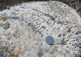
Crustal melting and granite magma formation occurred in the thickened Indian plate as well, south of the Indus-Tsangpo suture zone. These granites are exposed along the crest of the High Himalaya ranges. The Himalayan post-collisional granites are beautiful to look at.  Faceted crystals of black tourmaline and red garnet, along with gleaming flakes of white mica, are set in a white to pink colored matrix made up of quartz and feldspar. The picture to the left shows a tourmaline bearing leucogranite from the Greater Himalaya Sequence making up the Panchachuli range in Kumaon, Uttarakhand. I collected it from the moraines of the Panchachuli glacier.

The Karakoram Batholith is a composite body made up of magmas formed during different times. Older granitic rocks (150-70 million years ago) in this batholith formed in an Andean type margin setting wherein the Tethyan ocean crust was subducting under the Asian continental plate.

Certain metamorphic minerals like kyanite, sillimanite and garnet are thermobarometers. Their elemental ratios tell us about the temperature and pressure prevalent during mineral growth. Geologists estimate that the sillimanite and kyanite bearing Karakoram metamorphic rocks were formed at 35 km depth. These metamorphic rocks, along with the earlier formed granites of the Karakoram batholith, eventually partially melted to form the Baltoro granites.

Geologists have also been able to work out when metamorphism and melting took place. Using radiogenic uranium isotopes trapped in zircon crystals they find that peak metamorphism took place in several pulses. The oldest metamorphic event occurred around as early as 60-65 million years ago, with the heat source likely being the collison of the Kohistan Arc. Subsequent metamorphic pulses, driven by crustal thickening,  have been dated to about 45 million yeas ago and an even younger event to about 16 million years ago.

Magmas which form the Baltoro granites intruded and crystallized between 20 million to 13 years ago, similar in age to the post collisional leucogranites of the High Himalaya which are 24 million to 15 million years old . Crustal melting and granite formation in the Karakoram continued sporadically until around 9 million years ago.

The deep crustal processes occurring in the Karakoram region were also taking place eastwards in the thickened crust below Tibet. In the Karakoram, metamorphic rocks and granites formed in the lower levels of the crust now lie spectacularly exposed along the steep mountain sides. Erosion over the past 30 million years has removed over 35 km of overburden, exhuming these deep crustal layers. The Tibetan plateau however is made up of sedimentary and volcanic rocks. Only the uppermost parts of the crust are exposed here. Karakoram equivalent high grade metamorphic rocks and crustal melt granites, which undoubtedly exist in this region, still lie deeply buried in the subsurface.

Why is there such a difference between Karakoram and the Tibetan Plateau in the level of crustal exposure?  Take a look at the satellite imagery. Karakoram is covered by snow, while much of the Tibetan Plateau lies bare. Karakoram receives rain and snowfall from both the India summer monsoon as well as the north westerlies bringing winter moisture from the Mediterranean and Caspian areas. Tibet lies in the rain shadow of both these systems.  High rates of stream incision and the enormous erosive power of glaciers has resulted in high rates of exhumation in the Karakoram, eventually exposing deeply buried crust. Low erosion rates in the arid Tibetan region has failed to cut deeply into the crust, resulting in exposure of only the uppermost levels of the crust. Both Karakoram and Tibet have an average elevation of about 5000 meters. In the Karakoram though there is prolific relief, with peaks in the 7000-8000 m range and valleys at 2000-3000 m elevation. Relief in Tibet is subdued.

Climate plays an enormous role in shaping the topography and evolution of mountains.

Tuesday, December 18, 2018

Interviews: Meteorite Researcher And A Palaeontologist

Came across these two interesting interviews with a meteorite researcher and a paleontologist.

Meenakshi Wadhwa grew up in Chandigarh, North India. She wanted to study architecture. She ended up being a meteorite researcher. Quanta Magazine highlights her path from college to Director of the Center for Meteorite Studies at Arizona State University.

I totally related to this!

Applying from India, at a time when there was no internet, I had the Barron’s guide to graduate schools in the U.S., which was outdated by like 10 years at that point. I didn’t care about geography or any of that. I didn’t care if it was East Coast or West Coast or the Midwest. It was all half a world away.

.. and this was pretty amazing-

We get something like 100 tons of stuff falling on the Earth every single day. Spread over the entire planet, it’s not all that much if you think about it. Most of that is sand-size particles — tiny, tiny particles. Things that are about the size of a car, or van-size bolides, they hit a few times a year. Something the size of the Chelyabinsk meteor [which exploded over Russia in 2013], that’s a few times a year.

It's a terrific interview.

Dr. Lisa White is a paleontologist. Her specialty is Diatoms. These are single celled algae. They have a lot to tell us about past ecology and climate.  African Americans are poorly represented in the geosciences, and Dr. White as the director of education and outreach at the University of California Museum of Paleontology is actively working to increase diversity in the geosciences.

An excerpt:

I work nationally on a number of boards and with working groups and communities that are constantly examining the diversity in geosciences. We know our numbers don’t compare to engineering and the biological sciences. African American students are more likely to know about those fields and see the direct link to jobs. So we do have a bit of an image problem.

[It can be] difficult for students to have access to information about geosciences careers. There aren’t often a lot of standalone courses in high school. But there are a lot of interdisciplinary connections between all the fields, especially geoscience engineering, chemistry, water science, even agriculture…soil science.

Black Enterprise has the full interview.

Its always fun to read about how people arrive at a particular career trajectory.  A casual conversation, a book read during a holiday, or a trip taken with friends or for some other work can lead someone down  a career path they never thought they would take.

Thursday, December 13, 2018

Books: Colliding Continents And Reading The Rocks

These two beauties came by mail!

Readers know that I have been traveling and writing about the Himalaya the past few years. I had gone to Delhi in 2010 to attend a wedding and casually asked my cousin whether he could recommend a trip to the Himalaya. After the wedding I ended up in Mukteshwar, Uttarakhand for a short stay. I was hooked and have been going regularly since. I realized that I knew almost nothing about Himalaya geology. My Masters course in Pune had barely touched the surface. There were no Himalaya geology experts among the faculty and that showed in the minimal attention it was given in the syllabus. After all these years,  I decided to use my trekking trips to observe the local geology and teach myself about the geological architecture of the Himalaya.  I have been reading from the research literature too. After 6 years of trekking, field observations and reading I can say that I do have a broad understanding of the lithology and structure of the Uttarakhand Himalaya. Mike Searle's book, based on his 30 years of field and lab work in the High Himalaya and Tibet, covering almost the entire mountain chain from the western extremity in Pakistan to Bhutan and the Indo-Myanmar ranges in the east, is going to add enormously to my understanding of the details of the geological processes in operation at the zone of collision between India and Asia and how they formed this enormous mountain belt.

Marcia Bjornerud's book comes highly recommended from my Twitter friends and colleagues. It tells the story of the earth by delving in to and elucidating the basic geological processes in operation on the surface and in the interior of the planet. I have been actively pursuing geology outreach for over a decade now, through my blog mainly, but more recently by taking people out in the field and conversing with them about the rocks we see around us and their place in the geologic history of the earth. I have been trying hard to improve my ability to explain basic concepts in an easy to understand language. I have a feeling this fine book will help me refine that skill.

I will be posting my thoughts and some excerpts from these two books from time to time.

Sunday, November 25, 2018

India Shale Gas: Environmental Concerns

Shale gas is natural gas trapped in very fined grained sedimentary rocks like shales. These rocks are not very permeable. To release the gas trapped in the tiny pore spaces, the rock is fractured by injecting water, sand and various chemicals into it at very high pressure. Several million gallons of fresh water is needed for such ' fracking' activity at any one site. 

Shashikant Yadav, Gopal K Sarangi and M P Ram Mohan in an essay in the Economic and Political Weekly explain the environmental concerns that shale gas production poses in India.

Regarding the guidelines for environmental management released by the government -

Further, the guidelines mention that water management is one of the key concerns. They state that the major and prime difference being in the hydraulic fracturing technologies requiring a large volume of water; the activities are likely to deplete water sources and cause pollution due to the disposal of produced water. However, instead of dealing with the water-specific issues, the guidelines (apart from explaining existing provisions) stated that the generic environment clearance process adopted by the Ministry of Environment, Forest and Climate Change (MoEFCC) will suffice to ascertain water-related issues posed by fracking. But, MoEFCC has not laid down any specific guidelines, policies, or manuals differentiating between conventional and unconventional gases to grant environment clearance.  More recently, despite the gaps, on 1 August, 2018, the cabinet approved a policy allowing companies to exploit shale gas in contract areas that were primarily allocated to exploit conventional gas.

..and this in the context of the ambiguous legal framework surrounding groundwater -

Considering the limited water legislation in India, the implementation of fracking may result in geopolitical and legislative complexities. For instance, shale rocks are usually adjacent to rocks containing useable/drinking water known as “aquifers.” While implementing the hydraulic fracking, the shale fluid can easily penetrate to aquifers leading to groundwater contamination. This contamination may result in methane-poisoning of water used for drinking and irrigational purposes. To avoid such contamination, as per industry standards, a project proponent must maintain a distance of 600 metres between aquifers and fracture zones (Davies et al 2012).

The Indian water legal regime is far away to make such specific observations, as aquifers are not defined in any of the Indian environmental regulatory or legal regime leading to a free pass for unregulated mixing of shale fluid and aquifers. Moreover, the landless have no right to groundwater, and accordingly peasants and tribal communities who have no ownership rights over land have no right on groundwater. Also, a project proponent may easily exploit groundwater while implementing the hydraulic fracking process with none or limited accountability of their actions.  In such a situation, the intent of “Public Trust Doctrine” is defeated, and the precautionary principle will be non-implementable.


Open Access.

Sunday, November 11, 2018

Stalactites And Other Calc Tufa Deposits Along Bageshwar Shama Road, Kumaon Himalaya

Traveling from Bageshwar to Shama, in Kumaon Uttarakhand, I came across a wondrous calc tufa deposit about a kilometer south of Kapkot village.

 The map below shows Bageshwar and Kapkot along Route 37. (Permanent Link).


Calc Tufa are calcium carbonate deposits which form on land in a subaerial environment. They are made up of the minerals calcite and, less commonly, aragonite. The most familiar of calcium carbonate deposits are sea floor and beach accumulations of shells and skeletons of marine organisms. Upon burial and hardening they turn into limestones. In the Proterozoic, before animals evolved the ability to biomineralize, vast thicknesses of limestones formed in the oceans by inorganic and bacterially mediated precipitation of calcium carbonate. Limestones that form in saline as well as fresh water lakes are also known.

Calc Tufa forms in the vicinity of springs, waterfalls, along river banks, caves and along hill slopes. They have a chalky texture, porous fabric and organic looking shapes. This is a result of calcium carbonate encrusting microbial, algal and moss colonies that inhabit these settings. Associated with these porous friable looking forms are more denser crystalline deposits. These are stalactites and various types of laminated and globular crusts. They are collectively called speleothems. They form generally in a cave setting by abiogenic precipitation from thin films of supersaturated water. This particular deposit containing both tufa and speleothems was along a steep hill slope with large cavities. The substrate rocks are the Mesoproterozoic age Deoban limestone and dolostones (made up of mineral dolomite). They are estimated to be around 1.5- 1.6 billion years old.

All along the exposure the rocks were shattered by prominent fracture zones. Rain water is weakly acidic. As it falls and moves through the cracks and fractures in these rocks it dissolves the minerals calcite and dolomite, becoming enriched in dissolved carbon dioxide (CO2) and calcium.  The partial pressure of CO2 (a measure of dissolved CO2 concentration) in this groundwater is more than the partial pressure of CO2 in the atmosphere. When groundwater enters a cave or emerges on a hill slope as a spring discharge, the lower partial pressure of CO2 in this open setting causes a degassing of CO2 from the groundwater. This results in the pH of the water to increase slightly, which in turn causes supersaturation of calcium carbonate in solution. Precipitation of calcium carbonate then begins on the cave walls and roof and on the hill slopes. It is possible that removal of CO2 by microbial photosynthesis may also be playing a role in triggering precipitation.

These tufa deposits occur at many places along the Bageshwar to Shama road. We finally stopped for a closer look at a largish looking deposit about a kilometer south of Kapkot. This was strictly road side geology on my part. We spent about half an hour at the deposit and so I am not presenting any detailed analysis or insights regarding this feature.

This is a complex deposit made up of varied types of tufa. We managed to photograph some beautiful calc tufa morphologies which I am posting below. My thanks to Pushkaraj Apte ( @pushkarajapte ) for contributing many of the photographs.

Lets get an idea of the size of the deposit. That's me, standing in front of the large cavern. You can see stalactites in the background.


 A peek inside the large cavity. It is about 3 meters in height and about 4 meters in width. I could have easily stood inside it. However, I did not enter it, fearing I would break some delicate mineral deposits which have formed on the floor of the cave.


Speleothems

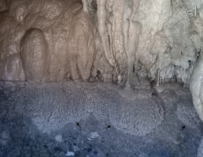
Stalactites 1: The most striking of the formations are these stalactites. They range from thick columnar forms (1) which are more than a meter in length to smaller centimeter long thin delicate drips (2). The cave is damp. There is a thin film of water covering these columns suggesting ongoing mineral precipitation and growth of the stalactites. The floor of the cavern was also encrusted with deposits and partially covered with tufa debris.


 Stalactites 2: Along the hill slopes, exposed Deoban carbonate strata form ledges. Stalactites are growing on the undersides of these ledges. The bigger ones are about 1-2 feet in length.


 Botryoids:  At places botryoidal clusters (cave grapes) are seen. These hang from the roof (1) and accrete away from walls (2). They form by either radial or concentric growth of calcite (or aragonite) from a nucleation site. Each botryoid is about a centimeter or so in diameter.


Thin Platy Crusts: These thin (cm scale)delicate layers likely form in shallow films or pools of stagnant water on the floor of the cavity.


Flowstones?: These banded crusts  have formed on a slope from flowing water and likely represent abiogenic precipitation of calcite (flowstones). Alternatively they could be stromatolitic crusts formed by precipitation of calcite atop microbial sheaths and mats.


Calc Tufa:

Phytohermal Tufa: These are calcified moss deposits (a foot or so in height) which are formed on the floor of the cavity. They preserve the bushy morphology of the moss colonies. Calcite encrusted and eventually entirely replaced the moss colonies, turning them into fossilized organic structures.


Microhermal Tufa or Phytohermal Tufa: The thin tube like structures (few cm in length) of this calc tufa deposit suggests that it formed by mineral encrustation of filamentous algae or bacterial colonies. However, I cannot be sure. This too could be a moss colony.


Spongiform Tufa: Massive looking with dispersed holes. Such structures from by mineral encrusting organic matter (moss, microbial mats) draping the hillsides. The open spaces between the organic matter and decay of vegetation gives the deposit a sponge like texture. Some larger cavities (about 6 inches across) are lined with layered mineral deposits.


I found this broken piece along the road side next to the deposit. It is made up of small globular aggregates and columns which have accreted upon a substrate of spongiform tufa.


In this transverse section you can see clearly the calcium carbonate layers that have built up the column.


A cross section of the larger stalactites will also reveal its layered nature. Stalactites with such growth layers are of importance in reconstructing past climates. The oxygen in the calcite (CaCO3) provides the clue. Variations in the ratio of the two isotopes of oxygen (O18/O16) which are bound up in calcite are indicators of differences in the strength of rainfall. The lighter isotope (O16) is preferentially retained in the vapor phase. During phases of weak monsoons or drought, rain becomes enriched in the heavier isotope (O18). Calcite layers precipitated from this water will be enriched in the heavier isotope. In contrast, during strong monsoon phases, rain and groundwater becomes relatively enriched in the lighter isotope. As a result, calcite layers will inherit a 'lighter' oxygen isotope signal.

For the Indian subcontinent, reconstruction of the past variability of Asian monsoons going back hundreds to thousands of years, are based on precious few data points, spread rather sparsely across India. Recently, Gayatri Kathayat and colleagues published a study of Indian monsoon history over the past 5700 years based on the oxygen isotope record of cave stalactites from Sahiya in Uttarkhand, located about 200 km WNW of where we were. Judging by the size of some of the stalactites, I am guessing that deposition at this Kapkot site has been going on for a few hundred years at least. I wonder if this deposit can be a new paleo climate data source.

I did have another intriguing thought. Is the profusion of calc tufa deposits along road cuts in this region just a coincidence? Is it possible that blasting and cutting the hill side for building the road enhanced fractures and triggered collapse of blocks, resulting in the formation of caverns, and creating conditions favorable for calc tufa precipitation?   If so, then this deposit may be at most a hundred years old. Wild!

Sunday, November 4, 2018

Landscapes - Gogina To Munsiyari

I just finished a fabulous trek in the Kumaon Himalaya, Uttarakhand. We started from Gogina village. The route took us to Namik, then northwards along some high ridges towards Sudamkhan Pass. The plan was to turn eastwards at Sudamkhan Pass and walk along a high shepherd's trail towards Khaliya high ridges, and then descend towards Munsiyari. But some very nasty weather forced us to turn back from Sudamkhan. We then took a lower altitude route southeastwards, and after a few days walk ended up just near Birthi Falls roadhead. A taxi picked us there and took us on an hour long drive to the town of Munsiyari.

The map below shows the location of Gogina, Namik, Birthi and Munisyari.


We climbed from around 5000 ft starting at Gogina to a maximum of around 12, 500 feet near the Sudamkhan area. After Namik there was no village until  we reached Birthi, and so we passed through some glorious isolated wilderness areas, ascending from temperature broadleaf forests to alpine tundra like environs made up of grasslands and meadows and up to more bare rocky heights.

The terrain is made up of medium to high grade metamorphic rocks of the Greater Himalaya Sequence. I noticed amphibolites, mica, garnet and feldspar gnessises, mica schists, phyllites, calc silicates (metamorphosed clay bearing limestones) along the way. However, the pace of the trek required me to keep walking along with my friends... so I did not do much geology on this trek.

Below are some pictures I took during the trek.

1) A view of the Lesser Himalaya from Gyan Dhura village (before we reached Gogina).


2) A house in Namik Village


3) So many geological stories written in to the lovely building stones of Namik Village


4) We climbed above Namik Village and set up camp in this lovely meadow.


5) Walking through a lush forest above Namik


6) Above the tree line, a trail leads to a shepherd's lonely outpost.. route towards Sudamkhan Pass.


7) The desolate yet hauntingly beautiful landscape near Sudamkhan Pass.


8) That's me, taking in the stunning surroundings near Sudamkhan Pass.


9) Gneisses of the Greater Himalaya Sequence exposed along the high bare ridges.


10) At Bajemania meadows after we descended from the Sudamkhan area. Watching an afternoon storm build up in a distance.


11) Our pack horses enjoying a meal as fresh snow cover the higher slopes.


12) Autumn colors glow in the late evening sun.


13) The majestic Panchachuli Range at sunset. View from Munsiyari.


.. with promises to keep traveling in the Himalaya.

Wednesday, October 17, 2018

Dessication Cracks In Mars Lake Bed

This Comment and Reply published in the August 2018 issue of Geology is worth reading.

Desiccation cracks provide evidence of lake drying on Mars, Sutton Island member, Murray formation, Gale Crater: COMMENT Brian R. Pratt

Desiccation cracks provide evidence of lake drying on Mars, Sutton Island member, Murray formation, Gale crater: REPLY N. Stein; J.P. Grotzinger; J. Schieber; N. Mangold; B. Hallet; D.Y. Sumner; C. Fedo

The argument concerns the origin of polygonal shaped ridges found on the surface of mudstones deposited in a Martian lake. These millimeter to centimeter high ridges made of sand were interpreted as having formed by sand filling in dessication cracks that form on the surface of a drying lake bed. The alternate view argued is that the sand was injected into cracks formed during seismic events taking place on early Mars.

New about Mars is usually dominated by grand questions about evidence for extraterrestrial life. But scientists inch towards answering such bigger themes by working the nitty gritty. In this case, grit filling up cracks in a mudstone. Such a debate may seem arcane, but understanding these details matter. They form small but essential building blocks of a knowledge base, incrementally adding to the larger picture.

Mineralogy Of The Earliest Animal Shells

Carbonate sedimentology and evolution. Two of my favorite subjects converge in this interesting study published in the September 2018 issue of Geology.

Calcium isotope evidence that the earliest metazoan biomineralizers formed aragonite shells-
Sara B. Pruss; Clara L. Blättler; Francis A. Macdonald; John A. Higgins

Ediacaran Cloudina and Namacalathus are among the earliest shell-forming organisms. The debated carbonate phase of their skeletons, high-magnesium calcite or aragonite, has been linked to seawater chemistry and pCO2, yet independent constraints on the original mineralogy are lacking. We present a new method to distinguish primary skeletal mineralogy using δ44/40Ca values and trace element compositions of the skeletons and associated cements. Ca isotopes are useful because they are relatively insensitive to diagenetic alteration during burial, and they vary with the primary mineralogical phase of carbonate. We applied this method to microdrilled carbonate and cements associated with both Namacalathus and Cloudina skeletons from the Ediacaran Omkyk Member of the Nama Group in southern Namibia. These data demonstrate that both organisms originally produced aragonitic skeletons, which later underwent diagenetic conversion to calcite. We suggest that calcium isotopes can be used to further constrain unknown skeletal mineralogies through time and to reassess the relationship between seawater chemistry and the mineralogy of biocalcifiers.

Different animals groups acquired the ability to precipitate hard protective shells made up of calcium carbonate at different times between the latest Neoproterozoic (~ 580-541 mya) to early Paleozoic (541 - ~ 450 mya).  What is the larger picture of the evolution of the biomineralization in different animal groups and the mineralogy of the skeleton? Through geologic time the chemistry of sea water has oscillated from that favoring the precipitation of aragonite and high magnesium calcite to that favoring the precipitation of low magnesium calcite. From Late Neoproterozoic to Middle Cambrian sea water chemistry favored the precipitation of aragonite and high Mg Calcite. Animal groups which evolved skeletonization during this time largely adopted aragonite to build their skeletons. Animals which first evolved biomineralization in the Late Cambrian to Ordovician times, during the time of calcite seas, adopted calcite skeletons.

In most animal groups, skeletal mineralogy was conserved even when sea water chemistry changed later in history. There have been only rare instances of animals changing the mineral phase used to build its skeleton. I wrote about one such instance in the Mesozoic when some groups of molluscs switched from  aragonite to calcite. The most prominent example is from the Hippuritoidea (rudist) bivalves. The switch to calcite shells seems to have triggered an evolutionary diversification beginning in the Late Jurassic. By Late Cretaceous times rudist bivalves were so abundant that they displaced corals (which built their skeletons with aragonite) as the chief reef builders in the shallow shelf environments.

Fascinating topic!

Saturday, September 15, 2018

Geology Photo Contest

The Centre for Education and Research in Geosciences, a geology outreach group based in Pune, is organizing a photo contest. Entry is open to all. The selected entries will be exhibited during their annual Geology Week event to be held in Pune from October 8 to October 12. Last date for entry in September 21 2018.

Brochure.


.. and go to this webpage for details regarding the photo contest: Geology Photo Contest

Please share widely!

Tuesday, September 11, 2018

Before The Himalaya: Story Of A Late Cretaceous Subduction Zone


My article on the geology of the upper catchment of the Brahmaputra River in southern Tibet has been published in The Wire Sciences. This region is technically called a suture zone. It contains the remnants of the Tethys Ocean floor made up of basaltic oceanic crust and overlying deep sea sediments. These rocks were deformed and uplifted during the India Asia collision.

I focus on a paper on the Jiachala Formation by Hanpu Fu and colleagues published in a recent issue of Science China Earth Sciences. They use a technique known as detrital zircon geochronology to resolve a long standing problem about the age of that sedimentary deposit. In my article I explain how this technique works. I also elaborate on the broader story these deposits tell us about plate tectonics and the beginnings of the Himalaya.

An excerpt:

In the Cretaceous Period, the Indian plate, which had been moving northwards since the breakup of Gondwanaland, was approaching the Asian continent. The southern edge of the Asian continent was lighter continental crust, whereas the leading part of the Indian plate was denser oceanic crust. As a result, in the zone where the the two plates converged, the denser Indian plate slid below the Asian plate, forming a subduction zone.

As the Indian lithosphere sunk deeper into the mantle, it heated up and released water trapped in sediments and hydrated oceanic crust. This water penetrated the overlying Asian plate, lowering the melting point of its rocks and triggering magma generation. This buoyant magma rose through the Asian continental crust. Some of it reached the surface, resulting in extensive volcanism. The rest solidified in the subsurface, forming giant bodies of granite known as batholiths.

Such terrains have the grandiose name of magmatic arcs. The town of Leh and the surrounding settlements in the Indian region of Ladakh are situated partly on a magmatic arc.

Two sedimentary basins since developed south of this arc. Immediately adjacent to the magmatic arc was the forearc basin. A deeper depression, known as the trench, formed further away on the Indian oceanic lithosphere, at the junction where the Indian plate had slid under the Asian plate. Both were receiving sediments derived from the erosion of the Asian continent.

During subduction, slices of the Indian plate were scraped off and thrust to the surface. Such fault-bounded piles of sediment and oceanic crust are called accretionary wedges, and they, along with a chain of oceanic volcanoes  that formed to the west in the region between Ladakh and Kohistan, would have been the first island ranges formed in the Tethys Ocean between India and Asia.


 Read the complete article here.

Saturday, September 8, 2018

Geoscience Education Woes In India

Dilip Saha of the Indian Statistical Institute, Kolkata,  has written an editorial in Current Science on the many problems with geology education in India.

He identifies a lack of attention to field work and the quality of teachers as the two major weaknesses that need correction.

I agree with many of the points he has made. I had a very poor quality field training experience during my Master's education at University of Pune (now Savitribai Phule Pune University). That was somewhat compensated for by some very good classroom teaching. Across State Universities and local colleges, the quality of teaching suffers not just because subject experts are not up to the task, but because many departments are understaffed and don't have subject experts.  Often, just two or three faculty end up teaching all the subjects.

I will also add that besides the obvious improvements in field courses, teacher quality and pedagogy, a module on research ethics is desperately needed. This is not a geology specific issue. Plagiarism is a big problem in Indian academia. I occasionally mentor students from local colleges. I have found out, to my dismay, that copying and pasting material from a research paper in to one's thesis seems to be commonplace. Students don't even realize that they are crossing serious ethical lines.

Open Access.

Thursday, August 23, 2018

Proterozoic Upper Vindhyan Succession: Fossils And Age

I came across a remarkable paper by S. Kumar published in the December 2016 issue of The Palaeontological Society of India. It is an overview of all the published reports of megafossils from the Proterozoic age Vindhyan Basin of Central India. The findings read like a special issue of Retraction Watch. I am not implying any fraud or scientific misconduct (neither does S. Kumar), and the papers in question have not been retracted either. Rather, he concludes, based on a rereading of earlier reviews and new analysis, that there has been a widespread misinterpretation of data. Practically all megascopic features interpreted variously as trace fossils (burrows, trails, scratch marks), impressions and body fossils are not fossils. They are abiotic in origin. Only some carbonaceous megafossils represent the remains of large microbial communities.

The map below shows the outcrop pattern of the Vindhyan Basin.


Source: Candler C. Turner et. al. 2013

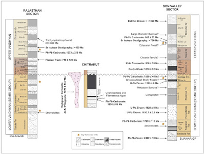
..and this figure summarizes our evolving understanding of the age range of the Vindhyan sedimentary succession.


Source: Geoffrey J. Gilleaudeau et. al. 2018

The most sensational and controversial of fossil reports from the Vindhyans are from the lower part of the succession. In the late 1990's and continuing in the early 2000's, Dr. Azmi, a researcher from the Wadia Institute of Himalaya Geology, reported microscopic embryo like globules,  rod like and filamentous microfabrics and oddly shaped mineral fragments. These fossils were found in the Rohtas Limestone and the Tirohan Dolomite of the Semri Group. He interpreted some of the globules to be animal embryos and the odd fragments as 'small shelly fossils', essentially bits and pieces of shells of marine animals. Based on this identification he claimed that the rocks were Late Neoproterozoic to Early Cambrian in age (~ 650 Ma to 520 Ma; Ma = mega annum = million years). This claim though has never gained wider acceptance.

First, since his discovery, improving geochronology of the Lower Vindhyans firmly brackets their age as between 1.7 Ga years to 1. 6 Ga (Ga= giga annum= billion years). And second, no Cambrian age animal fossils have been found from rocks younger than the Rohtas Limestone and Tirohan Dolomite. These shallow marine sediments should have yielded a prolific Cambrian fossil record. The consensus now is that those fossil remains are microbial and eukaryotic algal forms, and the odd shaped mineral fragments are just that; odd shaped inorganic mineral growths. Dr. Azmi's claim does not require a revision of Vindhyan stratigraphy.

An even more subversive fossil claim was made by A. Seilacher, P.K. Bose and F. Pfluger in 1998. They reported to have found burrows of triploblastic animals from the Chorhat Sandstone (dated to about 1.6 Ga) of the Lower Vindhyan Semri Group.  They accepted that the rocks are more than a billion years old and suggested that multicellular animals had evolved more than half a billion years before the appearance of the first animal body fossils in the Latest Neoproterozoic to Early Cambrian times. This claim too has been rejected by most workers. As S. Kumar writes in his review, the burrows have been shown  to be syneresis cracks, resulting from subaqueous shrinkage of sediment. They are not fossils. Molecular phylogeny indicates that multicellular animals originated between 800 Ma and 650 Ma and discernible megascopic fossils, in the form of traces, impressions, and body parts, appear first by around 560- 550 Ma. Any claim of megascopic metazoan 'fossils' in rocks older than 600 Ma needs to be treated with extreme skepticism.

In summary, most paleontologists now accept that there is no credible evidence of fossils of multicellular animals in the Vindhyan sediments. The youngest Vindhyan sediments are thought to be considerably older than the Cambrian (base of the Cambrian is 541 Ma).

When did Vindhyan sedimentation end? What is the age of the youngest Vindhyan rocks? This is one of the conundrums in Indian stratigraphy. Different types of data and methods of dating rocks have come up with conflicting ages.

Only three direct dates for the Upper Vindhyan Bhander Group are available. The Lakheri Limestone in the Rajasthan sub basin shows a date of 1073 Ma +- 210 Ma. The overlying Balwan Limestone has been dated to 866 Ma +- 180 Ma. About 60 m of sediment overlies the Balwan Limestone.  The Bhander Limestone in the Son Valley sub basin has yielded a date of 908 Ma +- 72 Ma. In the Son Valley, there is about 400 m of sediment overlying the Bhander Limestone. There is no direct method available yet to date these youngest rocks.

According to S. Kumar, the Maihar Sandstone, which is the uppermost Vindhyan strata exposed in the Son Valley, are around 650 Ma or slightly younger. The few non-carbonaceous remains that actually are fossils according to S. Kumar are found in these rocks. They are the microbial mat structure Arumberia and the body fossil Beltanelliformis minuta, which recently has been shown to be of cyanobacterial affinity. They are both Ediacaran age (637 Ma - 541 Ma) fossils. Kumar concludes that Vindhyan sedimentation in the Son Valley continued well into the Neoproterozoic, finally terminating in earliest Ediacaran times.

In contrast, an older age range is being hinted at by two very different types of data.  Bijaigarh black shales of the Kaimur Group have been dated to around 1200 Ma. The diamond bearing Majghawan kimberlite intrudes the Baghain Sandstone of the Kaimur Group near the town of Panna in Madhya Pradesh. It has been dated to about 1073 Ma. The Kaimur Group is dated between 1200 Ma and 1100 Ma. The kimberlite does not intrude the overlying Rewa and Bhander strata. They are younger than 1073 Ma, but apparently not much younger. The magnetic signatures frozen in the kimberlite match those preserved in the Rewa and Bhander rocks, suggesting that deposition of the Rewa and Bhander sediments did not persist for too long into the Neoproterozoic. The Bhander Limestone has recently yielded a date of 908 Ma (+- 72 Ma). Vindhyan sedimentation may have ended by 900 Ma.

Support for this scenario comes from the age of detrital zircon found in the Maihar Sandstone. The zircon has yielded a date of 1020 Ma. This date reflects the time when the zircon crystallized out of a magma. Zircons from this igneous rock were then eroded, transported and deposited in the Vindhyan basin. The Maihar Sandstone thus cannot be older than 1020 Ma. But, there is also an absence of zircons younger than 1020 Ma in the Maihar Sandstone. Geologists doing provenance work on the Vindhayans agree than the Aravalli orogenic belt to the west was an important source of sediments into the Vindhyan basin, as was the Central Indian Tectonic Zone (CITZ) to the south. Both of these belts could have yielded the 1020 Ma zircons, since they both contain igneous rocks of that age. The CITZ lacks igenous activity younger than this. But magmatism took place to the west of the Aravalli orogen between 873 Ma to 800 Ma (Erinpura Granite) and between 780 Ma and 750 Ma (Malani rhyolites and associated plutons). The erosion of these two igneous provinces could have provided a source of younger zircons to the Vindhyan basin. Their absence has been taken to imply that the Vindhyan Basin had closed by that time.

I am putting up these contrasting age signals here, but I don't really have a strong position on either of them. For one, geochronology of the Upper Vindhyans is still sparse and the few dates have come with large margins of error. I don't have the expertise to evaluate the magnetic data. The zircon data might seem to make a strong case for an earlier termination of Vindhyan sedimentation. But there is an alternate explanation for the lack of younger zircons in the uppermost Vindhyan sediments. The Erinpura Granite and the Malani igneous rocks lie to the west of the Aravalli belt. Orogenic activity  around 1 Ga, which deformed and uplifted the Delhi Group sediments, would have formed significant topography and a barrier to rivers flowing eastwards into the Vindhyan basin. Thus, a provenance cutoff rather than an end to sedimentation could explain the lack of younger age zircons.

Some workers have suggested that the Vindhyan sub basin to the west in Rajasthan closed earlier by around 900 Ma, but sedimentation continued until early Ediacaran times in the eastern parts of the basin exposed in the Son Valley in Madhya Pradesh.  Geoffrey J. Gilleaudeau and colleagues used variations in carbon isotopes of carbonate rocks to suggest age ranges for Vindhyan rocks in Rajasthan and the Son Valley. They found that carbon isotope values in carbonate formations in Rajasthan did not vary much and fitted the pattern observed for the late Mesoproterozoic (slightly older than 1 Ga) elsewhere around the globe. However, another study by Bivin George and colleagues of  the Balwan Limestone, which is the uppermost carbonate unit in the Rajasthan sub basin, showed substantial shifts in carbon isotope values through the section. The Balwan Limestone has been recently dated to about 866 Ma, but with a margin of error of +- 180 Ma! Bivin George and colleagues suggest that these variations match the 800 Ma globally synchronous Bitter Springs carbon isotope anomaly. Considering the presence of a 60 m shale layer above the Balwan Limestone, they put  the closure of the Vindhyan Basin in Rajasthan at around 770 Ma.

In Son Valley, carbon isotope values in the Bhander Limestone showed oscillations from enriched in the heavier isotope to sharply lighter values. This pattern is seen throughout the Neoproterozoic (younger than 1000 Ma) in sections elsewhere around the world. The sharp variations are thought to be due to large environmental perturbations that punctuated the Neoproterozoic from time to time.

During warmer climes, in healthy ecosystems, photosynthesizing marine organisms preferentially suck up the lighter carbon (C12) isotope. Sea water gets enriched in the heavier isotope (C13) which makes its way into carbonate minerals, resulting in 'heavier' or positive C isotope values of carbonate rock.  Environmental crises may cause a population crash of photosynthesizers. More of the lighter isotope is now available to enter carbonate minerals, resulting in  'lighter' or negative C isotope values of carbonate rock.

One problem in having a high confidence in this isotope curve matching is the inadequate geochronology of the Upper Vindhyans. Limestone ages in the Rajasthan sub basin have large margins of error (up to 200 Ma). Just one direct date of 908 Ma +- 72 Ma is available for the Bhander Limestone in the Son Valley sub basin. This means it is difficult to assign a particular pattern of variation to a specific Neoproterozoic interval. The technique has real potential but currently also underscores the need for sharper geochronology data.

However, the fossils Arumberia and Beltanelliformis found in the Maihar Sandstone support this scenario of a diachronous end to Vindhyan sedimentation. But there are niggling doubts too. The Sturtian (717 -643 Ma) and Marinoan glaciations (650 - 635 Ma) took place during the Neoproterozoic, covering much of the earth in ice. These glaciations ended with ice transported tillite deposits overlain by distinctive limestone or dolomite layers known as the 'cap-carbonates'. But there are no reports of unequivocal glacial deposits in the Rewa and Bhander sediments. Why their absence? Is that a hint that they are older than the Cryogenian Period i.e. older than 720 Ma, or is it because India was located at lower latitudes which were not glaciated? It is noteworthy that the latest Neoproterozoic (~ 590 Ma) Blaini Formation exposed in the Lesser Himalaya near Nainital and Mussoorie does contain glacially transported deposits.

But if the Upper Vindhyans are older than the Cryogenian, then what about the Ediacaran age fossils from the Maihar sediments?...

watch this space.

Saturday, August 18, 2018

Technology: Carbonate Sedimentology

Just a quick note to point out the range of instrumentation now available to sedimentologists for analysis of samples. This is from a study of Ordovician age sediments by Yihang Fang and Huifang Xu, published in the June 2018 issue of the Journal of Sedimentary Research.

An excerpt:

 A micro-laminated carbonate with alternating dolomite–calcite layers from the mid-Lower Ordovician St. Paul Group from the Central Appalachians in southern Pennsylvania was examined using optical microscopes, X-ray diffraction (XRD), scanning electron microscopy (SEM) with X-ray energy-dispersive spectroscopy, electron microprobe analysis (EPMA), scanning transmission electron microscopy (STEM), laser-induced fluorescence (LIF) imaging, short-wave infrared (SWIR) imaging, and X-ray fluorescence (XRF) imaging. The sample is composed mainly of two types of layers. Dolomite-dominated layers are darker in color, generally thinner, and contain detrital minerals such as quartz and feldspar. In contrast, calcite-dominated layers are lighter in color, thicker, and contain less detrital minerals supported by microcrystalline calcite matrix. In situ XRD, LIF, XRF, and SWIR results show that organic remnants are enriched in the dolomite layers. The coincided spatial distribution confirmed a positive correlation between dolomite and organic matter, and hence provide evidence for microbial-EPS-catalyzed formation of sedimentary dolomite.

That is a lot of heavy weight toys!!

The researchers were trying to come up with an answer to one of the long lasting problems in sedimentary geology; that of the origin of the mineral dolomite.

I am not going into this paper in detail. I have not read it.  Let me just say that it has been suspected that microbial communities living on the ocean floor and in the sediment column may catalyze the precipitation of dolomite and this study confirms that dolomite rich layers contain organic matter. The dolomite may form at the sediment sea water interface by precipitation directly out of sea water or more commonly by replacement of the aragonite or calcite sediments during shallow burial.

On a broader time scale, dolomite abundance through the Phanerozoic does seem to correlate well with episodes of lower atmospheric oxygen concentrations and consequently less oxygenated sea water. See this figure spanning the Phanerozoic Era ( McKenzie J.A. and Vasconcelos, C.  2009). This relationship between ocean anoxia and dolomite abundance may well hold for the Precambrian too.


Anaerobic bacteria can thrive under such anoxic conditions.  Sulfate ions in sea water are thought to be a hindrance for dolomite formation. Anaerobic bacteria  remove these ions from sea water and pore fluids by sulfate reducing respiration, thus creating conditions favorable for precipitation of the mineral. They may also present specific types of organic substrates which enable easy nucleation of dolomite crystals.

For more details on the origin of sedimentary dolomite, do see my post The Dolomite Problem- Peeking Under the Hood

Tuesday, July 31, 2018

Papers: Himalaya Foreland Basin Evolution

Foreland basins are moat like depressions that form in response to the loading of the crust by a rising fold and thrust mountain belt. They get filled up by sediment derived from the erosion of the mountain chain. The sediment composition of foreland basins and how it has changed through time is therefore an archive of the uplift and erosional history of the orogen. The Himalayan foreland basin contain a few kilometer thick pile of sediments. One broad scenario of foreland basin evolution goes like this. The oldest of these foreland sedimentary successions of Palaeocene-Mid Eocene age (~ 55- 45 my) are marine deposits formed in the ever narrowing Tethys Ocean. Uplift of the region due to the ongoing India-Asia collision resulted in the complete withdrawal of the sea. There was no sedimentation for 10-12 million years. After this depositional hiatus, sedimentation resumed in Early Oligocene times (~ 31 my) in a continental fluvial setting and continues till today.

This timing of events representing the transition from marine to continental conditions has been challenged by some workers. They have proposed that the depositional hiatus is of different magnitude at different places depending upon the effect of local tectonics. Estimates of the duration of the unconformity between marine strata and the overlying fluvial deposits range from 25 million years (early withdrawal of the sea) in the Kohat Basin of Pakistan to 3 million years (marine conditions persisting until around 31 million years ago) in the Subathu Basin of Himachal Pradesh, India. Continental depositional environments then formed between 28 million years ago to around 20 million years ago in different basins. River systems have deposited a thick succession of sediments since.

About 1 -0.5 million years ago these sediments were uplifted to form the well known Siwalik ranges. The locus of deposition shifted southwards. The alluvial plains of the Ganga river system is the present day foreland basin.

In this map of the Himalayan orogen, the southernmost belt, abbreviated as Ts, is the deformed foreland basin.


Source: An Yin 2006

..and in the satellite imagery, the foreland basin are the hill ranges to the south of the brown line. This line is a system of thrust faults that place the Lesser Himalaya on top of the foreland basin strata.

 
Provenance fingerprinting of the oldest foreland sediments indicate a Himalayan source. That tells us that incipient ranges in the collisional zone formed by around 50 million years ago. Since then, successive pulses of thrusting have uplifted terrains of differing composition. Their exhumation and erosion is recorded in the changing sediment mixture of the foreland basin strata. The schematic below reconstructs the Early Miocene to Pliocene uplift history of the Nepal Himalaya. The Dumri Formation and the Siwalik Group are the foreland basin sediment archive of this uplift.


Source: Peter G DeCelles et. al. 1998.

I've come across quite a few papers on these Himalaya foreland basin sediments. They focus on using a variety of techniques like sedimentary facies analysis, petrography, geochemistry and geochronology to unveil foreland basin geometry, foreland drainage patterns, paleo-climate and soil formation, and the timing of emplacement and erosion of different thrust sheets.

1) Evolution of the Paleogene succession of the western Himalayan foreland basin - B.P. Singh 2013.

2) Evolution of the Himalayan foreland basin, NW India : Yani Najman et. al. 2004.

3) Eocene-early Miocene foreland basin development and the history of Himalayan thrusting, western and central Nepal:  Peter G DeCelles et. al.  1998.

4) Neogene foreland basin deposits, erosional unroofing, and the kinematic history of the Himalayan fold-thrust belt, western Nepal: Peter G DeCelles et. al. 1998. (Behind Paywall).

5) Detrital geochronology and geochemistry of Cretaceous–Early Miocene strata of Nepal: Implications for timing and diachroneity of initial Himalayan orogenesis: Peter deCelles et.al 2004. (Request full text).

6) The Os and Sr isotopic record of Himalayan paleorivers: Himalayan tectonics and influence on ocean chemistry: John Chesley et.al. 2000. (Request full text).

7) Early Oligocene paleosols of the Dagshai Formation, India: A record of the oldest tropical weathering in the Himalayan foreland: Pankaj Srivastava et. al. 2013.

Update: August 1 2018

Geologist Vimal Singh reminded me of some more studies on early foreland basin evolution as well as the excellent work of Rohtash Kumar on various aspects of the later Siwalik Group sediments. I am adding these papers to the list.

 8) Marine to continental transition in Himalaya foreland - Bera et.al 2008

9) Reconstructing early Himalayan tectonic evolution and paleogeography from Tertiary foreland basin sedimentary rocks, northern India- Yani Najman and Eduardo Garzanti 2000 (Behind Paywall)

10)  Sedimentary  Architecture  of  Late Cenozoic  Himalayan  Foreland  Basin  Fill: An  Overview:  Rohtash Kumar et. al. 2011

A collection of Rohtash Kumar's papers on the Siwaliks can be viewed here.

I was somewhat unfamiliar with the Eocene-Early Miocene age deposits of the Himalayan foreland, and so was glad to have found studies that deal with the record of the earliest stages of Himalayan uplift.

Open access except where indicated.

Sunday, July 22, 2018

Mount Abu Geology

A reader asked me about the geology of Mount Abu and how it relates to the Aravalli fold mountains. Mount Abu is a popular tourist destination in the Sirohi district of Rajasthan. It forms a distinct elevated area ( ~ 5,500 feet ASL) and provides a much needed respite from the heat of the Rajasthan plains.

Here is my short note.

Mount Abu is a batholith. That means it is a big body of granite, made up of magma which cooled deep in the subsurface.

The satellite imagery below shows the Mount Abu hills in relation to the Aravalli fold mountains.


This magmatic episode is part of what is known as the Malani Igneous Suite. The term refers to an assortment of mostly felsic igneous rocks (magmas enriched in silica, aluminum and potassium) ranging from large intrusive bodies like the Mt Abu batholith, lava fields resulting from volcanism (Malani Rhyolites), and mafic (iron, magnesium, calcium rich magmas) and felsic dikes intruding the margins of the province. This was the result of a fairly prolonged phase of magmatism that affected the western margin of the Aravalli orogenic belt. The magmatic activity occurred between 780 -750 million years ago.  So, it is much younger than sedimentation and orogeny of the Delhi Supergroup (which ended about 1 billion years ago) and is not considered as part of the Aravalli/Delhi Supergroups. The thinking is that after Delhi orogeny, this part of the Indian craton underwent extension (was pulled apart), triggering granitic magmatism.

The detailed geological map shows Mount Abu batholith and other stratigraphic and tectonic elements of the Aravalli craton (continental block) and fold mountains. The Western Margin Fault roughly marks the zone of contact between the Aravalli craton to the east and the Marwar craton to the west. The Delhi orogeny is believed to have resulted from a convergence and suturing of these two cratons about 1 billion years ago.


Source: Joseph Meert and Manoj Pandit 2014

Here is a link  to an article on the Malani Igneous Suite with a useful map of the distribution of various igneous bodies in this province: http://www.mantleplumes.org/Malani.html

One additional point is that there were earlier magmatic episodes affecting the western margin of the Aravalli craton marking the culmination of the Delhi orogeny. This includes the 970 million year old granitoids of the Ambaji region, believed to represent crustal melting at the terminal stages of the Delhi orogeny. Younger than these are the post orogeny Erinpura Granite. This too was a protracted magmatic episode lasting the time span from 870 to 800 million years ago. Erinpura granites are collectively shown as post-Delhi granites in the map by Meert and Pandit. Note that both the Erinpura Granites and the Mt Abu batholith occur at the juncture between the Aravalli and Marwar cratons. Such a region would have lines of weaknesses inherited from earlier collision and deformation episodes making it susceptible to be reactivated as rifts and loci of magmatism.

Finally, why did the Mt. Abu granites that formed in the subsurface get elevated to heights of around 5,500 feet? The Aravalli mountains too have ridges which reach around 3000 feet. The Aravalli craton is bounded by two great NE-SW trending fault systems. The Great Boundary Fault to the east and the Western Margin Fault to the west. There are also innumerable NE-SW and some NW-SE trending fracture and fault systems (lineaments) which break up the crust into rigid blocks. Many of these originated during Archean and Proterozoic crustal deformation. Some new lineaments may have formed during the Jurassic breakup of Gondwanaland (A B Roy 2006).  Mount Abu may be an example of a block uplift, resulting from movements of the crust along these lineaments, perhaps in response to stresses originating from the India-Asia collision. The Aravalli fold mountains too have likely been rejuvenated and seen some recent uplift (Bhu et.al. 2014) These movements took place in the Neogene to Quaternary times, in the past 20 million years or so.

Saturday, July 14, 2018

Papers: Global Tectonics, Cryogenian Period, Himalaya Miocene Lakes

I've come across quite a few interesting papers on diverse topics in the past couple of weeks. Most of them are 'big question' themes, dealing with processes taking place on global scales. Here are the links.

Global Tectonics:

1) Subduction Initiation of the Wilson Cycle - In plate tectonics, the Wilson Cycle refers to cyclical ( frequency of 100's of millions of  years) breakup of continents and the opening and closing of ocean basins. But how is subduction initiated and new convergent plate boundaries formed? Some good examples from the Western Pacific margin and eastern Indonesia.

2) How Subduction Broke Up Pangaea - Was it top down forces.. i.e. the pull exerted by subducting slabs or was it the horizontal traction exerted by a convecting mantle (bottom up) that broke up the supercontinent?

3) Why is Africa Rifting? - Insights into the formation of the famous East Africa rift system.

4) Gondwana Large Igneous Provinces: distribution, diversity and significance - Synopsis of several papers that explore the link between prolonged magmatic episodes, tectonics, climate shifts and sedimentation patterns in Gondwana continents.

Neoproterozoic:

1) Snowball Earth climate dynamics and Cryogenian geology-geobiology - In the Cryogenian Period, between around 715 to 635 million years ago, the earth was blanketed in two prolonged glaciations. Before these glaciations, the earth was a microbial planet. The end of these glaciations is associated with the evolution of multicellular complex life. What were the conditions during the Cryogenian Period that influenced the evolution of life?

Himalaya:

1) Oligocene‐Miocene Great Lakes in the India‐Asia Collision Zone - Mount Kailash is an important pilgrimage site for Hindus. The sediments that make up this mountain were deposited in narrow basins in the India-Asia collision zone. They preserve a record of surface environments and geodynamic mechanisms operating within the suture zone during the convergence of India with Asia.

All Open Access.

Friday, July 13, 2018

Sutlej Paleochannels- More Details

A while back I had written a post in response to a paper (Ajit Singh et. al. 2017) on the paleo-Sutlej river. The study used geochemical analysis to identify ancient channels of the river. Today, the Sutlej flows out of the Himalaya and joins the Indus River. But this study showed that until about 8000 years ago, the Sutlej (or at least a strand of the river) flowed along a different course. Its paleo-channels coincide with  the course of the river Ghaggar in Haryana and Rajasthan in northwest India. This topic is of relevance in studying how rivers may have impacted agricultural practices and settlement patterns of the Harappan Civilization. The geography of the river Ghaggar also matches that of the river Saraswati, described in the Rig Ved. There is therefore considerable interest in working out the detailed history of these rivers.

I had pointed out that an earlier paper by Liviu Giosan and colleagues has used topographic criteria to come to a similar conclusion as Ajit Singh and colleagues. Giosan's study stressed that today the Sutlej and Yamuna flow along deeply incised valleys that were cut in the early Holocene (~10,000 to 8700 years ago). The absence of such valleys in the region between the present day Sutlej and Yamuna indicates that the Ghaggar channel was not being fed by glacially sourced rivers since 10,000 -8700 years ago.

The relief rendition below is from Ajit Singh's paper. It shows clearly the incised valleys of the Sutlej and Yamuna. I had overlain the blue line and suggested that if the Sutlej had flowed into the Ghaggar in early Holocene, there should have been an incised valley along the blue line.


As it happens, Sanjeev Gupta, who was the lead scientist of the study by Ajit Singh and colleagues, is a reader of my blog. He emailed me and has provided more insights regarding these paleo-channels.

I am posting his comments below with his permission.

My comment from the earlier post- The modified relief rendition below also shows the course of the abandoned Sutlej incised valley. Note that this valley is much narrower than the Sutlej and Yamuna incised valleys. Also, trace these narrower incised valleys upstream and you can see that they originate in the Siwaliks. There are no deep extensive incised valleys along the route I have marked in blue. The Sutlej would have carved a prominent incised valley roughly along the blue route had it been flowing into the Ghaggar during most of the early and mid Holocene. Its absence suggests to me that the valley annotated as the abandoned Sutlej incised valley was really carved out in the earlier part of the Holocene by the smaller Ghaggar river originating in the Siwaliks.

Sanjeev Gupta's reply - Just to respond... we only see the incised channel in the SRTM where the valley is not completely infilled. Indeed where we see the valley in SRTM it is not the base of the incised valley. but a partially infilled valley. So along the blue line you have drawn there is likely to have been a valley but it is entirely infilled.

My comment (with regards to the 'abandoned Sutlej incised valley' in the above relief rendition) - (it)....was really carved out in the earlier part of the Holocene by the smaller Ghaggar river originating in the Siwaliks.

Sanjeev Gupta's reply- This is not possible because all the geochemistry signature is of the Sutlej - the base of the valley actually occurs in the stratigraphy.

We have some newer data that better constrain the timing of incision but I stress the topographic surface is not the base of the incised valley - that lies in the subsurface.

...end.......

So, Sanjeev Gupta's view is that present day topography is not necessarily a more reliable guide to the course of these ancient rivers. Geochemical fingerprinting is the way to go.

Update July 22 2018:

Liviu Giosan posted a comment which led to an extended exchange with him regarding this topic. I have copied his comments below with his permission.

Me- Hi Liviu- was going to message you about my post when I saw your comment. Regarding Sanjeev Gupta's view, wondering if this is a matter of scale. The subsurface paleo valleys he says exist were much smaller valleys carved by a waning Sutlej and hence got infilled? Not quite the wider incision profile carved later by the river  along the present course.

Liviu Giosan - A matter of scale, time since abandonment, and location relative to a sediment source. Maybe I do not see Sanjeev's point. His work confirmed ours for holocene and in adition showed a pre-Holocene channel. A recent paper by Dave et al. showed the same thing for Yamuna.

Me- thanks. Can you send me the link to Dave et. al.?

Liviu Giosan - I can send you the paper. Please elaborate: what is Sanjeev's point?

Me- He hasn't elaborated. Those two short para's  i put up was all he emailed. I guess he is saying that there are incised valleys in the interfluve subsurface but are now infilled and so not picked  up by SRTM.

Liviu Giosan - That may be true but I doubt they will be all the way in filled unless they are old (preHolocene). After all his work shows a network of holocene streams in the region using SRTM. Further geochemistry we did  downstream so far is pretty (Clift et al. not cited by Sanjeev) shows no holocene contribution from Sutlej. Even more Sutlej incised since early Holocene making it almost impossible to feed shallow channels on the interfluve. This needs to be interpreted with all available evidence. Geochem is no silver bullet in isolation.

..end...

Sanjeev Gupta did mention to me that the point about topography is important but they did not have the space to address it in their paper. So, while there are differences in viewpoints about emphasis on techniques,  the overall data does point to a switch in the course of the Sutlej around 8-10 thousand years ago.

The paper on the paleo-Yamuna that Liviu Giosan mentioned is by Aditi Krishna Dave and colleagues. They examine detailed lithologs of the Chautang channel near the town of Hisar, Harayana, and with OSL (Optically Stimulated Luminesence which indicates the time of burial of sediment) age constraints propose that the Yamuna, which was flowing westwards and joining the Ghaggar-Hakra downstream of its confluence with the Sutlej, changed course and started flowing eastwards by 24 thousand years ago. I'll put up a short post on that shortly.