Showing posts with label field trips. Show all posts

Wednesday, November 15, 2023

River Nira Meander

 So near Pune, yet I had never been to this location near Bhor.

It is popularly known as necklace point. The river Nira loops its way through the countryside forming a series of lovely meanders. A high point overlooking the valley allows a clear view of this feature. 

I was on a drive with some friends, spending the day exploring the back waters of the Bhatgar and Nira Deogarh dams. We eventually reached Warandha Ghat, one of the spectacular passes linking the Deccan Plateau with the western coastal plain. 

At the edge of the plateau, high relief exposes sheer rock faces. 

The grand scale of Deccan Volcanism is manifest so clearly in the lava flows traceable over hundreds of meters despite the afternoon haze.

On a satellite image, X marks the view point looking south towards the big meander.  

This is a beautiful area near Pune to spend a day out.

Tuesday, May 23, 2023

Panchachuli Glacier Area Landscapes

After a gap of four years, I visited Darma Valley again earlier in the month. This well known trekking destination is situated in the Kumaon Himalaya of Uttarakhand. With me were a bunch of nature lovers eager to understand the geology of the Himalaya. This was a geology tour organized by Deep Dive India. I accompanied the group as the geology expert.

We spent most of our time in the high grade metamorphic terrain of the Greater Himalaya and the low grade metamorphic Tethyan realm. The Panchachuli Glacier and its deposits provided for discussions on climate change and  a more recent geologic past. Reaching these remote locations meant a day long drive through the winding roads of the Lesser Himalaya. We made quite a few stops to observe different types of strata. The highlight was a road cut that exposed a synclinal fold, a beautiful example of the nature of deformation pervading the Lesser Himalaya.

I'm sharing a few images of the landscapes around the Panchachuli Glacier, which is the main attraction of this region. Although, as our group discovered, there is more exciting and varied geology to observe here.

Dantu, our base village was cold when we arrived in the evening. A light snowfall made for a memorable experience. Permanent link for this video- Dantu Snowfall

A dusting of white lingers on the forest tops after the night's snowfall. A view from Dantu.

A stand of Bhojpatra (Himalaya Birch) lights up the High Himalaya slopes. 

The weather had cleared up by the next day and we were treated to majestic views of the Greater Himalaya. 

A burbling icy stream made for a soothing break on the high walk towards Panchachuli base camp. In case you are unable to view the video in the post, click on this link - Icy Stream Panchachuli.

The Post Master's home in village Naagling. For decades this beautiful home doubled up as a guest house for weary trekkers. The family no longer lives here. I hope there is a way to maintain this heritage structure. 

Explaining Miocene granite intrusions and Himalaya mountain building. Can anyone ask for a better classroom? 


Join me next time!

I'll also be writing about some conglomerate and sandstone boulders that I keep observing in these high Kumaon valleys. The outcrops are not accessible to me, but I have some ideas on what these rocks signify.

Monday, July 25, 2022

Field Photos: Italy Swiss Alps

A friend recently went for a trek to the Italian and Swiss Alps and sent me these stunning photos.

All Alps pics by Dr. Sushma Date.

A view along the Santa Magdalena or the Alp Suisse trail.

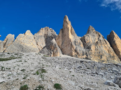
Imposing Pinnacles along the Tre Cime di Lavaredo hike in the Italian Alps.


 A close up of limestones and dolomites in the Italian Alps.


 A panoramic view of the distinctive landscape along the trail.


There is so much to see here in terms of geomorphology and how glacial erosion throughout the Quaternary Period has carved out the terrain. But my friend was also walking past rock outcrops that stand witness to one of the most enduring debates in sedimentary geology: the origin of that distinctive layering in these sediments.

The section of the Alps my friend was trekking in is made  up of Middle to Late Triassic age (225 -200 million years ago) limestones and dolomites. They formed in the warm tropical waters of the western Tethys Ocean. A closer examination of the layering reveals that the sediments were deposited in two broad subenvironments of a shallow sea, the intertidal zone and the subtidal zone. Intertidal and subtidal sediments alternate to form a depositional pulse or a cycle. Such couplets are stacked to form the thousands of feet of strata observed in this part of the Alps.

What could be causing the alternation of the intertidal and subtidal environments? Thick intervals of these Triassic deposits are made up tidal mud flats overlain by restricted lagoon sediments, or tidal mud flat overlain by open circulation subtidal environments, or lagoon deposits overlain by mud flats. When beds are traced laterally, these same environments grade into each other. Such inter-fingering arrangements suggest that environment adjacent to each other migrate, resulting in a vertical succession of alternating sediment types.  

Geologists recognize that such changes can be 'áutocyclic', driven by mechanisms internal to the sedimentary basin. A site of biological productivity and sediment production may choke itself by overproducing sediment. The loci of sediment production may shift to a more favorable site. Episodic storms keep redistributing sediment and reorganizing current directions . Such feedbacks result in similar environments appearing and disappearing from any one location, resulting in a cyclic sedimentary record. 

There are also successions of strata in the Triassic Alps which show a very different arrangement of sediment types. In this variation of cyclicity, intertidal mud flats may be overlain by relatively deeper water subtidal sediments which in turn are overlain by a red soil layer. The formation of soil on top of subtidal sediments deposited in water depths of up to 10 meters or so indicates a substantial drop in sea level. The top of the exposed subtidal layer was then chemically weathered to form a soil. 

Autocylic shifts in environments are gentle nudges which push one environment over another. They can't generate such a big drop in sea level. There must be drivers external to this environment that may cause sea level to rise and fall at regular intervals. These external agencies or  'allocyclic' mechanisms have been invoked to explain parts of these Triassic sequences. 

What could be controlling the regular rise and fall in sea level? Long term (over millions of years) tectonic subsidence of the basin floor certainly would have created the accommodation space for the accumulation of sediment. However, geologists look toward a different mechanism to explain the repeated deepening and shallowing events observed in these Triassic strata. 

Climate change can cause regular shifts in sea level. During the past 2.6 million years of the Quaternary ice age, sea levels have fallen by as much as 100 meters during phases of continental glacier growth, and risen during inter-glacial times when ice sheets melt. These changes have taken place at intervals of 400,000 years in the early part of the Quaternary, changing to beats of 100,000 years over the past million years. Sea level changes due to growth and decay of continental glaciers are termed glacio-eustacy. Unlike autocycles which can have variable time spans, there is a fixed periodicity to these climate driven allocycles. 

We now know that these climate cycles are controlled by periodic changes in the earth's orbital parameters which cause cyclic variation in the amount of incoming solar radiation. Such Milankovic glacio-eustatic cycles, named after the Serbian mathematician who worked out the details of earth's orbital behavior, have been recognized during other times of widespread glaciation such as the Permian. 

Milankovic worked out that there are three types of orbital movements that affect how much solar radiation reaches the top of earth's atmosphere. The shape of the earth's orbit or eccentricity cyclically varies with a period of 100,000 years and with a longer period of 400,000 years. Obliquity, or the tilt of the earth's axis with respect to its orbital plane, changes every 40,000 years. The third type are Precession cycles of 26,000 years. This is the wobble or the direction the earth's axis points to.

The Triassic though was a very hot world! The earth's land masses, amalgamated in the supercontinent Pangaea, were situated across the equator. There were no continental glaciers to wax and wane and drive sea level change. Glacio-eustacy is not a workable explanation for these cyclic Alpine sedimentary sequences.

Of late many geologists have started pointing to groundwater storage in continental aquifers as a means of causing periodic sea level change. It does sound like a fantastical idea! Such groundwater mediated sea level changes go by the name of aquifer eustacy. Milankovic climate cycles may not trigger glaciation during hot earth periods. But they can modulate long lasting humid and arid phases, each lasting tens of thousands of years. Sea levels are lowered during hot humid phases as oceans lose water by evaporation while continental aquifers get recharged. During arid phases, water is lost from aquifers by evapo-transpiration and discharge, resulting in a rise in sea level. 

An inverse phase relationship between groundwater level and sea level is thus an expectation of aquifer eustacy.

There is enough water in continental aquifers to modulate sea level change of several meters. Here is an impressive statistic. There is approximately 25 million cubic kilometer of pore space in the upper 1 km of continents above sea level.  If this is completely filled with water, the amount will equal the volume of water in continental ice caps. Even a small fraction of these pore spaces actually getting filled with water or emptying of it can change sea levels by several meters. 

Recent short term measurements of the hydrological cycle supports the notion that groundwater storage can influence sea level. For example, very high rainfall over Australia and part of the southern Hemisphere in 2011 resulted in a drop of 7 mm in global sea level that lasted a few months. And the Gravity Recovery and Climate Experiment satellite data since 2002 indicates that increased land water storage has actually slowed down the rate of sea level rise by a small amount.

Can some of the Triassic sedimentary cycles of the Alps be attributed to aquifer eustacy? How can one track periodic groundwater change in geologic history and test whether they coincide with sea level changes? One proxy is to use lake sediments of the same age as marine sequences.  Lakes are connected to aquifers.  High lake levels are indicators of saturated aquifers. Lake levels drop as aquifers discharge. Geologists have been studying Late Triassic age lake sediments from the Newark Basin in  northeastern U.S. They have identified sedimentary cycles formed during alternating humid (high lake levels) and arid climate (low lake levels) phases. 

The broad time span of these lake sequences coincide with the time frame of some thick intervals of marine sedimentary cycles of the Alps. Whether individual lake and marine cycles are out of phase could not be worked out due to limitations in age resolution of strata. However, a Milankovic band 400,000 year periodicity has been estimated for these cycles, a finding strongly suggestive of  climate driven eustacy.  From another time period, some analysis of  Cretaceous age lake sediments of Songliao Basin of NE China indicated lake level highs coinciding with global sea level lows. This finding also hints that aquifer recharge and discharge may be primarily responsible for periodic sea level changes during a greenhouse earth when there are no continental glaciers to modulate sea levels. 

Such questions continue to be asked and the mechanisms behind generating sedimentary cycles of the Triassic has by no means been satisfactorily worked out. There are many types of cycles in the Triassic Alps, observed R.A. Fischer, whose seminal work in the 1960's opened up avenues of debate that continue unabated. Perhaps it is the spectacular setting and stark rock faces that lend themselves to bold hypothesis making, linking sedimentary rhythms to the celestial dance of our planet.  

Thursday, July 14, 2022

Field Photos: Iceland

More pictures arrived from different parts of the world. My friends visiting Iceland and the Alps sent me some stunning photos of landscapes and geology. 

Iceland. 

All pics by Biju Mohan.

Lava flows forming gentler slopes and steep rock faces. Notice the rough columnar jointing in the upper lava flow.

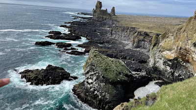
Where basalt plateau meets the sea. Cliffs and a wave cut platform.

Volcanic cone and crater.

A fissure or a crack through which lava would have poured out. These are present all over Iceland.  

Iceland predominantly has basalt volcanism, broadly the same rock type as the Deccan. It is one of the few locations where the Mid-Atlantic spreading center is exposed above sea level. This is a divergent plate boundary, where the European and North American tectonic plates (along with some micro-plates) are moving away from each other.

Biju asked me an interesting question; "Did the deccan area looked like present day Iceland sometime in the past? Is there evidence for numerous volcanoes in the Deccan?

Yes, a young Deccan volcanic terrain would have looked similar to Iceland in some aspects. Since in both places, the crust was pulled apart by extensional forces, long fissures or cracks formed and were the main passageways for magma to come to the surface. These fissures from where lava came out would have been visible in a young Deccan. They have eroded away now. What is left are dike swarms, essentially cracks plugged by sheets of magma. Many of these dikes represent the feeder passages from which lava ascended to the surface. So, an exhumed lower level is now visible. Volcanic cones would also have been visible. These have mostly been eroded away in the Deccan.

As such Deccan would not have seen the development of very large steep cones, since the lava type is runny, and does not pile up much to build cones. Iceland though, besides basalts,  has more of a silica rich sticky lava type, with more explosive volcanism,  and a more pronounced development of steeper volcanic cones. Remember the Eyjafjallajökull volcano that erupted in April 2010?

Fresh lava fields would have been clearly demarcated. In young volcanic terrains it is easier to pick out discrete eruptive episodes. Lava fields erupting from different vents overlap. Slightly older lava will change color due to weathering and also get colonized by plants. Fresher lava fields will be barren and likely steaming as well! In the much older Deccan , erosion has erased such differences. Exhumation doesn't always expose a pristine surface, rather a patchwork of vertical sections where one gets a two dimensional view is the common outcrop pattern, making recognition of such lava fields challenging to the untrained eye. 

Another similarity would have been the presence of active hydrothermal systems. Today, the Deccan volcanic system is extinct, but 65 million years ago, groundwater would have been heated by flowing through hot rock and proximity to magma. Fumaroles and hot springs would have been a common phenomenon. I have been collecting secondary minerals from the Deccan Traps since my college days, and I would have loved to have wandered through a young Deccan volcanic terrain, where hot mineral saturated water were depositing silica, calcite, and zeolite minerals in cracks and cavities of the basalts. 

The oldest lava flows in Iceland are mid- Miocene in age. Erosion has been sculpting landscapes for a good 15 million years. The result is some uncanny similarities with the Deccan. The 'Trap' topography, alternations between gentler and steeper slopes is also seen in Iceland. And along the Konkan coast, basalt and laterite sea cliffs look over flat wave cut platforms just like the Iceland coast. 

Sea cliff and a wave cut bench, Harnai, Konkan.


I'll close with this beautiful Iceland landscape. 


Coming soon.. Dolomite Alps and a geological conundrum.

Tuesday, May 10, 2022

Field Photos: Dikes And Gneiss

My friends have been traveling across India and sending me pictures of landscapes and rocks. I am doing field work vicariously.

Posting below a few pictures that I have received.

Dikes Intruding Bundelkhand Gneiss. Pictures by Rajesh Sarde.

These two photos were taken at the Ken River gorge in Madhya Pradesh, near a gharial sanctuary. 

The dark rock making up the floor of the gorge is a dike. It has intruded the pink colored gneiss rock. Notice that the gneiss is fractured. Intrusions follow major weak zones in the gneiss.  Being softer than the gneiss, erosion over time has removed much of the dike, forming a narrow valley.

And in this picture, an arm of the dike known as an apophysis can been seen. It is almost at right angles to the gorge.


The Bundelkhand Gneiss ranges in age between 3.2 billion to about 2.5 billion years ago. The mafic dikes, igneous rocks rich in iron and magnesium silicate minerals, intruded later into the granite gneiss. Recent geochronological work on the dikes suggest two distinct events of dike emplacement, an early episode dated to about 2 billion years ago, and a later one at 1.1 billion years ago. Interestingly, the magnetic signatures frozen in these dikes have been used to make inferences about paleogeography. The results indicate that the north and south Indian crustal blocks which had independent origins were in close proximity by about 2.5 billion years ago. 

The magnetic signatures of the 1.1 billion year old dikes throw up a puzzle. They match those preserved in the Upper Vindhyan strata and intrusive rocks, seemingly constraining the age of the Upper Vindhyan sequence to around 1 billion years. However, recent fossil finds which I wrote about in a recent article for Nature India point to the Upper Vindhyans being much younger, about 550 million years old!

Dikes Intruding the Deccan Traps. Pictures by Rajesh Sarde.

These two photos were taken at the base of Tamhini Ghat, west of Pune, near a popular trekking spot known as Plus Valley. The rocks are about 66-65 million years old.

As in the previous example, the dike has eroded away faster than the host rock forming a narrow depression. Notice the closely spaced jointing pattern or cracks in the dike. 


 In this photo, the sharp boundary between the dike and the basalt rock can be clearly seen.


 Tonalite Trondhjemite Gneiss, Palolem Beach, Goa. Picture by Aneeha

These rocks, abbreviated as TTG, are relicts of early continental crust. They are about 3.4-3.2 billion years old. They represent Archaean age magmatism that formed the lighter continental crust. Such TTG's  are found all across India. They are the oldest component of cratons, the nucleus of the first continents. These magmas are generally granodiorites, rich in sodium and calcium feldspars and poor in potassium feldspars. They were deformed and metamorphosed subsequently in to a gneiss, in the process acquiring a characteristic banding. 

Next time hopefully pictures from my own field trips!

Wednesday, January 22, 2020

Sedimentary Structures: Building Stones of Badami, Aihole And Pattadakal Temples

Is this sandstone slab in its original geological orientation (as when the sedimentary layers were deposited) or is it upside down? I'll answer this a little later, but first some background.


I recently visited the Chalukya style temples and rock cut monuments at Aihole, Pattadakal and Badami (6th -8th CE) in northern Karnataka and noticed some great sedimentary structures in the building stones. The term sedimentary structures refers to the shape and form sedimentary layers get sculpted into by the action of waves, currents, tides and wind during deposition of the sediment. The size of the deposited sedimentary particles and the orientation of layers are a reflection of both the vigor of the currents and waves and the direction of flow of water or wind.  


These monuments are made up of Neoproterozoic age (900-800 million year old) sandstones. Geologists have recognized using detailed sedimentological analysis that the sandstones formed mostly in a large braided river system that flowed in a northwesterly direction.

Between  roughly 1800 -800 million years ago, over the course of a billion years, the Indian continental crust sagged due to various tectonic forces to form several long lasting sedimentary basins. The Kaladgi Basin in which the Badami area sandstones were deposited is one such basin. The paleogeographic reconstruction below shows the position of the Indian continent at about one billion years ago and the location of the various sedimentary basins within it.


Source: Shilpa Patil Pillai, Kanchan Pande and Vivek S Kale: 2018: Implications of new 40Ar/39Ar age of Mallapur Intrusives on the chronology and evolution of the Kaladgi Basin, Dharwar Craton, India.

Much of this deposition took place in inland or epeiric seas that flooded the Indian continent. During intervals of sea level fall, rivers carved valleys and deposited coarse sediment. The Badami Cave sandstones are river deposits of the Kaladgi Basin. The stratigraphic column shows various sedimentary deposits of the Kaladgi Basin and their inferred environments of deposition.

Source: Shilpa Patil Pillai, Kanchan Pande and Vivek S Kale: 2018: Implications of new 40Ar/39Ar age of Mallapur Intrusives on the chronology and evolution of the Kaladgi Basin, Dharwar Craton, India.

The Badami braided river system was receiving sediment eroded from Archean age (>2.5 billion year old) rocks situated SE of the basin. These were granites, granodiorites, and low to medium grade metamorphic  rocks of the Dharwar craton (a large block of stable old continental crust). 

Land plants did not exist then. Weathered debris was moved quickly by surface flow into streams. Large sediment load, moving by traction i.e. by rolling and sliding on the stream bed, repeatedly choked the channels, forcing bifurcation of streams and formation of braids. Very broad braided rivers formed since there were no plants to stabilize banks.  The Badami sandstones (Cave Temple Formation) are technically known as arenites. This term indicates that the rock is made up of mostly coarse sand with very little finer sized mud. Accumulation of mostly coarser sand size and pebbly particles reflects a locale of repeated high discharges and vigorous currents which winnowed away the finer sized mud.  The braided river shown below as an example is from the Canterbury Plains of New Zealand.


 Source: Braided Rivers: What's the Story?

The Badami rocks preserve a record of  various subenvironments of this paleo-river. Picture shows channel and bar deposits in outcrop.


Source: Mukhopadhyay et. al. 2018; Stratigraphic Evolution and Architecture of the Terrestrial Succession at the Base of the Neoproterozoic Badami Group, Karnataka, India.

As river channels episodically migrated sideways and the basin floor subsided to accommodate more sediment, channel deposits and adjacent sand bars got stacked to form thick 'multi-story' sandstones. Each bed tells a story of a discrete depositional episode.


The arrangement of sand layers within each bed tells us about the subenvironments in which it formed and the energy and direction of water flow during deposition. I came across many types of these internal structures. I recognized tabular cross beds, trough cross beds, planar lamination and rippled beds. Water (or wind) can move & shape sand into piles or waves. Sand grains roll along the direction of flow, then avalanche down the steeper side (lee side) of the wave forming a layer inclined (cross) to the orientation of the main sand body. Successive avalanches form a set of cross beds. The graphic shows the formation of a set of cross beds.

 Source: Dr. Diane M Burns in Teaching Sedimentary Geology in the 21st Century.

Here is an example of cross beds from near the town of Badami.


And this one is from a building stone from Pattadakal temple.
 

Such cross beds were built by sediment avalanching on the lee side of migrating sand bars during high flow.

This picture show trough cross bedding from near the Badami cave complex. These represent the internal structure of migrating sinuous sand dunes on a channel floor. 


See this elegant explanation by Dawn Sumner, a sedimentologist at the University of California at Davis,  of how trough cross beds form.


Email subscribers who may not be able to see the embedded video, click on this link: Trough Cross Bedding Video.

And here is a beautiful example of trough cross bedding found in a Pattadakal temple building stone.


This is planar lamination on a slab at Pattadakal. The bed is constructed of parallel layers of coarse sand. It is interpreted to have been deposited in a high flow regime from sheets of water flowing over mid channel sand bars.
 

Ripples on a slab at Pattadakal. This is a rare preservation of a bedding surface showing rippled sand. Erosion usually cuts off the wavy upper part. These ripples indicate migration of small sand waves in a quieter flow regime on the channel floor.


Remember, cross beds are the inclined layers that form on the lee side of a ripple or wave or dune. Here are small cross sets on the floor of Aihole rock cut temple! These represent the cross beds formed by migration of small ripples. The ripples themselves have been eroded away. Arrows indicate the direction of water flow and cross bed accretion as ripples migrated.


Okay, let's go back to my first question. Is the slab I showed in the picture geologically upside down?

Yes it is. But how to tell?

As sand avalanches down the lee slope it forms a tail at the toe of the slope resulting in cross beds which become tangential to the floor. In picture the cross beds are tangential towards the top of slab i.e. that is actually the base.


Lets see at how the cross bed contact with the top and bottom bedding plane looks in an outcrop. Here is the original depositional orientation of cross beds manifest in this outcrop near Badami caves. They show a tail or tangential contact of the cross beds with the base. Since top of cross beds are not usually preserved they show a high angle contact truncated by upper bedding plane.


This slab is upside down too! Notice again the tangential contact of the cross beds (white arrow) is towards the top, which means that must have been the base. Yellow arrow points to high angle contact with the upper bedding surface. 


Towards the top of the exposed section of sandstone around Badami I came across some truly impressive examples of cross bedding. These particular exposures were on the crags opposite the four main Badami temples. There is a narrow passage past the archaeological museum and a short climb to the top. Take a look at these beauties!


These large cross beds reminded me of the inclined beds of wind blown sand dunes. Is it possible that abandoned sand bars were sculpted by wind in to big dunes? Or does this upper level sandstone represent, as a recent study suggests, the beginning of a marine incursion in to the basin? In this scenario, deposition of sand took place in high-energy shallow waters near the shore. These cross beds represent large migrating sand waves which were eventually shaped in to beach ridges and tidal bars.

The outcrops and building stones of these monuments mostly record the processes within the Badami braided paleo-river. 900 million yrs ago a complex of channels and bars, quieter pools and rippled sand beds existed where these temples stand today.


Do visit Aihole, Pattadakal and Badami and gaze at its splendid architecture and sculptures. But spare some time to appreciate the magnificent record of our natural history that these monuments preserve. 


Quiz- Is this slab upside down or in its true depositional orientation? 😉


Until next time....

Saturday, November 30, 2019

Field Photos: Natural Arch, Lava Channel NE Of Pune

Last Saturday I went for a field trip organized by the Centre for Education and Research in Geosciences. This is an outreach effort initiated by geologists Dr. Sudha Vaddadi and Natraj Vaddadi along with the student community from various Pune colleges. They undertake these programs regularly through the  year. We explored the Deccan Plateau region northeast of Pune.

On Pune Nasik Highway we turned east at Ale Phata. Our first stop was a little past Gulunchwadi . Across the road an inclined dike intruding into older basalt flows is visible. And a groundwater seep is seen along the contact between two basalt flow units.


Such water seeps can slowly weather and remove rock eventually creating larger passages and undercuts. We saw that just a few minutes ahead. Besides a small roadside temple is a steep stairway leading you into a streambed below. There you come across a wondrous natural arch.


I am not sure I have a good explanation of how exactly this feature formed. Was there a larger waterfall cascading from the top before? At the same time, groundwater seeping along the contact between the two flow units would have eroded rock material creating large passageways which eventually coalesced. Stream flow got directed along the bed of this large tunnel. Further down cutting by the stream has lowered the level of the stream bed, leaving a stranded 'bridge'. 

Also notice in the satellite picture below that the stream makes an abrupt turn at a couple of different points along its course. Its pathways appear to be controlled by fractures.They would have provided weak zones that focused and enhanced erosion.


From this site we proceeded to Mandahol Dam. A little north of this dam is a ridge line named Mhasoba Zap. Can you spot something unusual in the topography of the ridge?


The sinuous feature is an exhumed river of lava!  It erupted between 67 and 66 million years ago.

Basalt lava is less viscous and can flow for long distances. It can follow a preexisting valley or lows in the landscape, forming a lava channel. The image below is from a USGS monitoring station that has captured a lava channel formed during a recent eruption in Hawaii. 


The view in this photo at Mhasoba Zap is looking upslope. The winding ridge which you can follow up to the isolated hill in the background is the exhumed lava channel. It stands out about 50-100 meters above the adjacent plains. 


And here is the lava channel looking downslope. It continues for a distance of about 3 kilometers 'downstream' before dying out.


The margin of the channel (white arrows) are made up of a basalt which looks a little different from the basalt in the central parts of the channel. The margin rock is reddish in color. A closer look (in the field) will tell you that it is glassy to fine grained.  Lava at the margins cools quickly. This cooled lava gets broken up because of the stresses imparted by flowing lava in the center of the channel. This gives a fragmented character to the margins. The iron in the quenched glassy matrix rusts to impart a orange red hue to the rock.


In a close up I have outlined the base of the channel in orange lines.  Dr. Sudha Vaddadi who has mapped this region when she was working with the Geological Survey of India tells me that this entire ridge is actually a lava tube. The top has been eroded away! She was able to identify the 'roof' a km away downslope.


Lava at the surface cools and solidifies quickly. That leaves a tube or a pipe through which lava is supplied from the vent across long distances. The solid crust insulates and keeps the interior hot, allowing the lava to reach long distances from its source. The photo is of a lava tube from the Reunion Islands, a site of ongoing volcanism.

Photo Credit: Nandita Wagle

Let's take a closer look at the margin rock.   It is distinctive due to the reddish color and the fractured fragmented nature of the rock.  It has also been extensively affected by secondary mineralization. Cracks are filled with (white veins) of fibrous scolecite (zeolite family) and calcite.


Blobs and lava spatter accumulates at the margins, cooling and welding together to form an 'agglomerate'. The close up shows globular masses of lava stuck together. 


In this synoptic view, almost the entire lava channel is visible.  Downslope it breaks up into distributary 'fingers'. 


This really was a fun trip. From this lava ridge we traveled south and saw stalactites at the Duryabai Temple near Wadgaon Durya and then went further south to see the famous potholes in the Kukdi river bed near Nighoj village.  I will write about these features in a later post.

In the embedded map look for Malaganga Temple, Mhasoba Zap, Wadgoan Durya and Nighoj. 


Email subscribers may not be able to see the map. Follow this Permanent Map Link.

Although the Western Ghat escarpment with its spectacular views captures a lot of attention, the Deccan plateau region to the east and northeast of Pune has a lot of interesting geology and landscapes.

Get out there and explore!