Showing posts with label divergent plate boundaries. Show all posts

Thursday, November 24, 2022

Mid Oceanic Ridges: Geodiversity And Biodiversity

Mid Oceanic Ridges. Unlike continental mountain chains, these undersea mountain ranges are invisible to our day to day gaze. 

Yet, they are among the most dynamic of geologic features. They form where tectonic plates split and move apart, and new ocean floor is generated by upwelling magma. Sea water percolates through the cracks in this new crust, heats up in the subsurface and then rises carrying with it gases and metals. These vigorous hydrothermal circulation systems provide a link to exchange chemicals between the mantle and the crust. Varied microbial and macrofaunal communities colonize these environments depending on proximity to magma, the strength and chemistry of hydrothermal systems, and the nature of bedrock composition and fault controlled topography. 

Some specific geologic settings, those with serpentinite rocks,  have recently attracted great interest because they are thought to have provided the right combination of heat and chemicals to stimulate pre-biotic chemistry and the origin of life.

Gretchen L. Früh-Green and colleagues review this fascinating underworld, bringing out, both, the diversity of geologic processes at work and the resulting biodiversity that depends on this varied geology and energy supply. The introductory paragraph shared below gives an idea of the importance of this geological environment.

"Mid-ocean ridge (MOR) systems extend approximately 60,000 km around the globe and are the most dynamic and continuous tectonic feature on the planet (Fig. 1). On average, about 3.3 km2 yr−1 of new oceanic crust is generated at global spreading centres, which account for >70% of the total volcanism, and where about 60–70% of the Earth’s surface has been produced over the past 160–180 Myr (ref.2). Mantle melting, volcanism and faulting at MORs drive hydrothermal circulation that allows the transfer of heat, chemical compounds, metals and volatiles from the asthenosphere to the hydrosphere and biosphere. Approximately 75–80% of the Earth’s total heat flux occurs as the oceanic crust ages, and it is most pronounced at ridge flanks, where low-temperature fluid flow continues off axis for millions of years and contributes to global biogeochemical cycles. It is estimated that the volume of the ocean circulates through the oceanic ridge system in much less than 1 Myr (ref.6).

Spreading centres are one of the most extreme environments on Earth that can support oases of life at high temperatures and thriving in perpetual darkness. Microorganisms obtain energy from magmatic gases and chemical compounds of altered oceanic crust, rather than from light, through a process called chemosynthesis. In turn, many of these microorganisms symbiotically sustain macrofaunal communities that populate hydrothermal vent environments. The microorganisms with the highest known growth temperature on Earth are found within MOR hydrothermal systems and investigation of their genetic diversity has changed the current view of the tree of life".

I have put the last sentence of the first paragraph in bold to highlight the scale of this geological system. This is rich and rewarding reading. The paper is open access.

Gretchen L. Früh-Green, Deborah S. Kelley, Marvin D. Lilley, Mathilde Cannat, Valérie Chavagnac & John A. Baross: Nature Reviews Earth & Environment- Diversity of magmatism, hydrothermal processes and microbial interactions at mid-ocean ridges.

Thursday, July 14, 2022

Field Photos: Iceland

More pictures arrived from different parts of the world. My friends visiting Iceland and the Alps sent me some stunning photos of landscapes and geology. 

Iceland. 

All pics by Biju Mohan.

Lava flows forming gentler slopes and steep rock faces. Notice the rough columnar jointing in the upper lava flow.

Where basalt plateau meets the sea. Cliffs and a wave cut platform.

Volcanic cone and crater.

A fissure or a crack through which lava would have poured out. These are present all over Iceland.  

Iceland predominantly has basalt volcanism, broadly the same rock type as the Deccan. It is one of the few locations where the Mid-Atlantic spreading center is exposed above sea level. This is a divergent plate boundary, where the European and North American tectonic plates (along with some micro-plates) are moving away from each other.

Biju asked me an interesting question; "Did the deccan area looked like present day Iceland sometime in the past? Is there evidence for numerous volcanoes in the Deccan?

Yes, a young Deccan volcanic terrain would have looked similar to Iceland in some aspects. Since in both places, the crust was pulled apart by extensional forces, long fissures or cracks formed and were the main passageways for magma to come to the surface. These fissures from where lava came out would have been visible in a young Deccan. They have eroded away now. What is left are dike swarms, essentially cracks plugged by sheets of magma. Many of these dikes represent the feeder passages from which lava ascended to the surface. So, an exhumed lower level is now visible. Volcanic cones would also have been visible. These have mostly been eroded away in the Deccan.

As such Deccan would not have seen the development of very large steep cones, since the lava type is runny, and does not pile up much to build cones. Iceland though, besides basalts,  has more of a silica rich sticky lava type, with more explosive volcanism,  and a more pronounced development of steeper volcanic cones. Remember the Eyjafjallajökull volcano that erupted in April 2010?

Fresh lava fields would have been clearly demarcated. In young volcanic terrains it is easier to pick out discrete eruptive episodes. Lava fields erupting from different vents overlap. Slightly older lava will change color due to weathering and also get colonized by plants. Fresher lava fields will be barren and likely steaming as well! In the much older Deccan , erosion has erased such differences. Exhumation doesn't always expose a pristine surface, rather a patchwork of vertical sections where one gets a two dimensional view is the common outcrop pattern, making recognition of such lava fields challenging to the untrained eye. 

Another similarity would have been the presence of active hydrothermal systems. Today, the Deccan volcanic system is extinct, but 65 million years ago, groundwater would have been heated by flowing through hot rock and proximity to magma. Fumaroles and hot springs would have been a common phenomenon. I have been collecting secondary minerals from the Deccan Traps since my college days, and I would have loved to have wandered through a young Deccan volcanic terrain, where hot mineral saturated water were depositing silica, calcite, and zeolite minerals in cracks and cavities of the basalts. 

The oldest lava flows in Iceland are mid- Miocene in age. Erosion has been sculpting landscapes for a good 15 million years. The result is some uncanny similarities with the Deccan. The 'Trap' topography, alternations between gentler and steeper slopes is also seen in Iceland. And along the Konkan coast, basalt and laterite sea cliffs look over flat wave cut platforms just like the Iceland coast. 

Sea cliff and a wave cut bench, Harnai, Konkan.


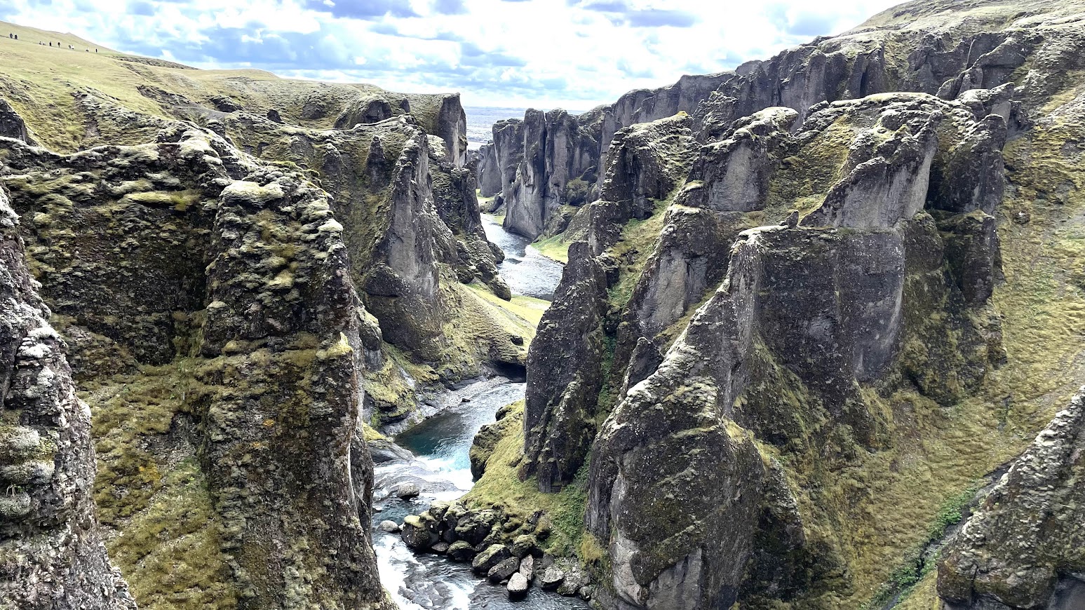
I'll close with this beautiful Iceland landscape. 


Coming soon.. Dolomite Alps and a geological conundrum.

Sunday, March 28, 2021

Himalaya Overview, African Population History, Iceland Volcano

 From past couple of weeks:

1) This is a fine synthesis of geological, geophysical, seismic and geodetic data of the growing Himalaya mountains. The review examines the interplay and feedbacks between seismic cycles and tectonic deformation. Earthquakes result in rock deformation and faulting. Tectonic structures developed this way over million of years, in turn, influence stress accumulation and the extent and location of earthquakes.

Building the Himalaya from tectonic to earthquake scales.

2) Holocene-age ancient DNA and genetics of extant populations is increasing our understanding of African population history.

The deep population history in Africa

3) The remarkable drone footage of the ongoing eruption of Geldingadalir volcano in Iceland.


Email subscribers who can't see the embedded video can view it here- Iceland Volcanic Eruption.

Wednesday, March 8, 2017

Papers: Tectonics And Physical Volcanology Of Deccan Traps

There are plenty of research papers on the geochemistry of the Deccan Basalts. But nature lovers and trekkers like me come face to face not with chemistry but with the physical forms of lava and the structural elements of the volcanic pile.

I found this list of papers most useful. They have helped me sort out my confusions regarding lava morphology and taught me something about the structural fabric of the western margin of the Deccan Volcanic Province.

1) Near N–S paleo‑extension in the western Deccan region, India: Does it link strike‑slip tectonics with India–Seychelles rifting? - Achyuta Ayan Misra Gourab Bhattacharya, Soumyajit Mukherjee, Narayan Bose

This is a structural analysis of the fracture systems that cut across the western margin of the Deccan province.  The area of study is the coastal plains, about 100 km north and south of Mumbai. The Indian western margin is a rifted margin i.e. it formed by the breakup of India with Madagascar (88 million years ago) and then Seychelles (64 million years ago). This type of margin is formed by tensional forces splitting apart continents and so you would expect normal faults, wherein blocks of crust have moved down along inclined fault planes.  Except here, the researchers find evidence of strike slip movement along sub-vertical fault planes. This means crustal blocks slid past each other. This implies oblique rifting with components of both extension and transverse movement between India and Seychelles. There are some really revealing field photos of this transverse (strike slip) movements.

2) Geology of the Elephanta Island fault zone, western Indian rifted margin, and its significance for understanding the Panvel flexure- Hrishikesh Samant, Ashwin Pundalik, Joseph D’souza, Hetu Sheth, Keegan Carmo, LoboKyle D’souza, Vanit Patel

Wait a minute. There are normal faults with downthrown blocks in this region too. And from the famous Elephanta Island. The fault planes dip eastwards producing easterly downthrows. That means the easterly crustal block has moved down. Again, some good field photos of fault planes and slickensides ( fault surfaces which get a polished striated appearance due to the frictional movement of rocks). These faults with easterly downthrows are found all along the west coast.  There is one near the proposed site of the nuclear power plant at Jaitapur in southern Maharashtra, which shows signs of intermittent movement over the past fifty thousand years. So, there is a very practical reason for understanding these faults.

3) Deccan Plateau Uplift: insights from parts of Western Uplands, Maharashtra, India- Vivek. S Kale, Gauri Dole, Devdutta Upasani and Shilpa Patil Pillai

This is a study of part of the Deccan plateau. I visited this region a few weeks back.  Very useful information of the various fracture systems that cut across the stacks of lava and their significance in terms of recent (Quaternary) crustal movements and controls on the drainage systems. Well thought out block diagrams illustrate the authors ideas very clearly.

4) Pahoehoe–a'a transitions in the lava flow fields of the western Deccan Traps, India-implications for emplacement dynamics, flood basalt architecture and volcanic stratigraphy-  Raymond A. Duraiswami, Purva Gadpallu, Tahira N. Shaikh, Neha Cardin

Good explanations of the morphology of basalt lava flows.  I really liked the sketches showing the internal structure of lava flows and the emplacement of pahoehoe lava fields with its transformation into transitional and a'a type lavas. Very useful guide for my next outing into the Deccan basalts!

Thursday, February 9, 2017

Why Is There A "Lost Continent" Underneath Mauritius

Yes, the term "lost continent" brings up visions of a lost world full of fantastic creatures that once existed deep in the earth's past. Or, of a civilization that once was, but was swallowed up by rising seas and which now only remains on the margins of human memory.

The "lost continent" underneath Mauritius is making news. It is more accurate to say that there is continental crust underneath the oceanic lavas of Mauritius. And that continental crust is very old. Geologists found crystals of zircon in young lava that erupted on Mauritius about 5.7 million years ago. The age of the zircon is however Archean in age, between 2.5 billion - 3 billion years. That means the zircon crystal did not form in the young lava, but belongs to the older foundation of the island. They were extracted from this Archean crust by rising molten material and brought to the surface about 5. 7 million years ago.

The crust making up the earth continents is primarily made up of granitic and andesitic rocks and sedimentary cover. This crust is light and thick (30km-40 km) and it sticks above sea level.  On the other hand, the crust making  up the ocean basins is made up of basalt and is denser and thinner (~10 km). So, what is Archean continental crust doing in the middle of the Indian ocean, surrounded by Cretaceous-Cenozoic oceanic basaltic crust?

The answer lies in the way Gondwanaland broke up, or rather the way India broke away from Madagascar about 88 million years ago. This was a continuation of the progressive breakup of Gondwanaland that began in the late Jurassic about 150 million years ago. A large rigid continent need not break into two clean pieces. Very often, the edges splinter. Several smaller fragments of continental crust are left isolated near the edges of the two continents.

The map below shows these continental splinters scattered in the Indian ocean as Madagascar and India broke apart and drifted away from each other.


Source: Lewis D. Ashwal, Michael Wiedenbeck, and Trond H. Torsvik 2017

Mauritius is part of a series of splinters that collectively are called Mauritia. These splinters were part of the Archean continental nucleus that made up Madagascar and the western Dharwar craton in south India.

Here is the interesting part that many news reports haven't touched on. Look closely at the map above. Trace the Carlsberg Ridge southwards. The Indian plate, which is drifting northwards, lies to the east of this ridge and the African/Somali plate to the west. Today, Seychelles and Mauritius is on the African/Somali plate and Chagos and the Laccadives on the Indian plate. But, when the initial separation happened about 84 million years ago, Seychelles and most of Mauritia were on the northerly drifting Indian plate. This is because 84 million years ago, the plate boundary between the Indian and African plates was formed by sea floor spreading in the Mascarene basin.

This is depicted in the  paleo-geographic reconstruction below. At 65 million years, the CIR or Central Indian Ridge is where sea floor spreading is forming the Mascarene basin. Seychelles and Mauritia lie to the east of this ridge on the Indian plate.

Source: Shankar Chatterjee et. al. 2013

Later, beginning around 62 million years ago and continuing up to about 41 million years ago, the loci of sea floor spreading jumped eastwards. The result was the formation of new plate boundaries between the Seychelles and Laxmi Ridge (62 mya) and between Mauritius and Chagos/Laccadives (42 mya).  These "ridge jumps", as they are called, formed the Carlsberg Ridge and  transferred Seychelles and Mauritius on to the African/Somali plate. Continued northward drift of India coupled with sea floor spreading and the formation of new oceanic crust along the Carlsberg Ridge has formed the broad oceanic basin of the Arabian Sea/ Indian ocean.

The process of continental breakup involves extensional forces that stretch and thin the crust. Fault movements cause a subsidence of crustal blocks. Many of the splinters at the edge of major continental margins are such thinned downfaulted blocks. They thus often get submerged under the sea.

Open Access

Tuesday, January 3, 2012

New Volcanic Island In The Red Sea

Nearly coinciding with the New Year, volcanic activity of the west coast of Yemen has given rise to a new volcanic island.


 From the NASA Earth Observatory article:

An eruption occurred in the Red Sea in December 2011. According to news reports, fishermen witnessed lava fountains reaching up to 30 meters (90 feet) tall on December 19. The Moderate Resolution Imaging Spectroradiometer (MODIS) on NASA’s Terra and Aqua satellites observed plumes on December 20 and December 22. Meanwhile, the Ozone Monitoring Instrument (OMI) on NASA’s Aura satellite detected elevated levels of sulfur dioxide, further indicating an eruption.

The activity in the Red Sea included more than an eruption. By December 23, 2011, what looked like a new island appeared in the region....


....The volcanic activity occurred along the Zubair Group, a collection of small islands off the west coast of Yemen. Running in a roughly northwest-southeast line, the islands poke above the sea surface, rising from a shield volcano. This region is part of the Red Sea Rift where the African and Arabian tectonic plates pull apart and new ocean crust regularly forms.

 The Red Sea is one arm of a great three armed rift system that includes the Gulf of Aden and the East African rift valley as the other two arms. If you want to know more about divergent plate boundaries and rifting along this complex system I would recommend this primer at Geology.com.

And don't forget to check out the image comparison tool with its cool slider at the NASA Earth Observatory website by clicking on the View Image Comparison option.