Yet, they are among the most dynamic of geologic features. They form where tectonic plates split and move apart, and new ocean floor is generated by upwelling magma. Sea water percolates through the cracks in this new crust, heats up in the subsurface and then rises carrying with it gases and metals. These vigorous hydrothermal circulation systems provide a link to exchange chemicals between the mantle and the crust. Varied microbial and macrofaunal communities colonize these environments depending on proximity to magma, the strength and chemistry of hydrothermal systems, and the nature of bedrock composition and fault controlled topography.
Some specific geologic settings, those with serpentinite rocks, have recently attracted great interest because they are thought to have provided the right combination of heat and chemicals to stimulate pre-biotic chemistry and the origin of life.
Gretchen L. Früh-Green and colleagues review this fascinating underworld, bringing out, both, the diversity of geologic processes at work and the resulting biodiversity that depends on this varied geology and energy supply. The introductory paragraph shared below gives an idea of the importance of this geological environment.
"Mid-ocean ridge (MOR) systems extend approximately 60,000 km around the globe and are the most dynamic and continuous tectonic feature on the planet (Fig. 1). On average, about 3.3 km2 yr−1 of new oceanic crust is generated at global spreading centres, which account for >70% of the total volcanism, and where about 60–70% of the Earth’s surface has been produced over the past 160–180 Myr (ref.2). Mantle melting, volcanism and faulting at MORs drive hydrothermal circulation that allows the transfer of heat, chemical compounds, metals and volatiles from the asthenosphere to the hydrosphere and biosphere. Approximately 75–80% of the Earth’s total heat flux occurs as the oceanic crust ages, and it is most pronounced at ridge flanks, where low-temperature fluid flow continues off axis for millions of years and contributes to global biogeochemical cycles. It is estimated that the volume of the ocean circulates through the oceanic ridge system in much less than 1 Myr (ref.6).
Spreading centres are one of the most extreme environments on Earth that can support oases of life at high temperatures and thriving in perpetual darkness. Microorganisms obtain energy from magmatic gases and chemical compounds of altered oceanic crust, rather than from light, through a process called chemosynthesis. In turn, many of these microorganisms symbiotically sustain macrofaunal communities that populate hydrothermal vent environments. The microorganisms with the highest known growth temperature on Earth are found within MOR hydrothermal systems and investigation of their genetic diversity has changed the current view of the tree of life".
I have put the last sentence of the first paragraph in bold to highlight the scale of this geological system. This is rich and rewarding reading. The paper is open access.
Geology enthusiasts will find the Milam Glacier trail captivating. The river Goriganga emerges from the glacier and flows in the Johar valley in this region. I walked the trail in Mid October, and came across a variety of geological features of interest. The trail begins in the village of Lilam, just north of the town of Munsiyari in the Kumaon region of Uttarakhand. It passes through the steep Greater Himalaya, and later northwards, through the Tethyan Himalaya.
The map below, intended more to show the geological set up, shows the trail as a red line. It depicts the trail only until Rilkot. Milam, the end of the trail, is about 20 km north of the extent of this map.
The Greater Himalaya (GH) and the Tethyan Himalaya (TH) are two thick slices of the Indian crust which were moved southwards by great thrust faults as India collided with Asia about 50 million years ago. Both the GH and TH are made up of sequences of rocks that formed on the northern margin of the Indian plate over a vast period of time. The rocks range in age from the Proterozoic to the Eocene (1.8 billion to ~50 million years old) The GH consists of rocks which were buried to great depths during the India-Asia collision and metamorphosed at high temperatures and pressures. On the other hand, the TH rocks experienced only shallow burial and show a light metamorphic imprint while retaining many of their primary sedimentary characteristics.
This post is mainly a visual journey intended to help trekkers make sense of the geology they will encounter along the trail. Short explanations accompany the pictures and videos.
The map above shows three major fault zones. All three dip (tilt) north. In Munsiyari, while you wait for your trekker permit to get processed, walk down the main bazaar road towards the petrol station. Keep a watch for the rock outcrops on your right. These are limestones of the Lesser Himalaya caught up in the Munsiyari Thrust Zone, the southernmost of the faults in this area.
The picture collage shows the deformation in the fault zone rocks. Shearing along the fault has produced a shiny smooth surface and a mica like character to the bedding surfaces. They will feel like talc to the hand, or like porcelain. Sedimentary layers also show folding and striations, two typical deformation features along faults.
This rock below, know as augen gneiss, is one of the iconic rocks of the Munsiyari area. It is among the oldest dated rocks in the Himalaya, estimated to be between 1.9-1.8 billion years old. While the limestones near the petrol station are positioned below the fault plane (footwall), the augen gneiss is part of the hanging wall (above the fault plane) of the Munsiyari Thrust. Notice how the white feldspar grain (porphyroclast) is deformed into a sigmoidal shape. The feldpar is an inch in length. White arrows denote the sense of motion along the fault.The Munsiyari Thrust, as is the case with other major thrust faults in the Himalaya, shows a primarily "top to the south up" sense of shear. This means that the thrust direction is southwards.
From Lilam, at the start of the trail, you will pass through another great fault zone known as the Vaikrita Thrust or the Main Central Thrust. The MCT carry the Greater Himalaya rocks in its hanging wall. Due to soil, scree and vegetation it is hard to see fresh rock outcrops. The picture shows the general disposition of the GH and their appearance (taken from a construction site near Lilam). These banded rocks are called gneiss and they formed when sedimentary rocks were subjected to high temperatures and pressures.
A few kilometers ahead near Bugdiyar, the Goriganga has cut a narrow gorge. It is an awe inspiring site! Check out this video. Permanent link - Goriganga Near Bugdiyar.
A road is being constructed between Lilam and Milam. Sections of it coincide with the old trail, while in other parts you can avoid the road and walk the old route. Ahead of Bugdiyar, from Nahardevi to Laspa, I walked along the new road which has exposed some amazing rocks. Here, you are walking along rocks which were buried to 20-25 kilometers depth and then exhumed! Conditions were so extreme, reaching more than 800 deg C, that the sedimentary/metamorphic rocks partially melted to form a rock with igneous and well as metamorphic features. These mixed rocks are known as migmatites.
The video shows a rock wall with migmatite gneiss. Notice the white bands which is the melt (leucogranite), while the darker layers are the source metamorphic rock. The video spans about 25 feet. Permanent Link - Migmatite Gneiss Nahardevi.
Another close up of leucogranite cutting across (dike) gneiss layers. The leucogranite magma then gets injected parallel to the layering or foliation, forming a sill (topmost light colored layer).The gneiss layers are about 2-3 feet thick.
Ahead, in the Laspa area, you walk across the northernmost of the great fault zones, the South Tibetan Detachment System, also referred to as the Trans Himadri Fault. Across this zone, you will notice a change in the metamorphic grade. The gneiss and migmatites give way to low grade metamorphic rocks like slate and phyllite and quartzites.
The pic shows an outcrop of carbonaceous slates and quartzites intruded by leucogranite (vein is 6-10 inches in width). The dikes and sills of leucogranites become rarer as you walk northwards and finally disappear by the time you reach Rilkot village. The rocks from hereon along the trail are part of the Tethyan Sedimentary Sequence.
From Rilkot you enter a landscape profoundly shaped by glaciers. The advance and retreat of glaciers since the Last Glacial Maximum (20,000 years ago) has left behind characteristic glacial deposits. The two prominent types of glacial deposits seen throughout this part of the trail are lateral moraines and glacial outwash terraces. Lateral moraines is debris carried by glaciers along the walls of the valley. They are recognizable as linear ridges. Outwash terraces form when glaciers retreat and the meltwater carry and deposit sediment across the valley forming a plain. Subsequently, the river cuts down through these deposits, leaving flat topped terraces high above the active river bed. For more reading on this topic do refer to Nawaz Ali and colleagues work on the glacial history of the Goriganga Valley.
The pic below shows the Goriganga at Rilkot. LM denotes a lateral moraine of the Shalang Glacier (from a side valley near Martoli). Its age is uncertain but some scientists estimate it to be a relict of a glacial advance that took place before the Last Glacial Maximum. T refers to a glacial outwash terrace formed during a period of deglaciation about 12,000 years ago.
Deglaciation between 16,000 years ago and 8,000 years ago resulted in two pulses of sediment deposition. Near Tola village remnants of these two episodes of terrace formation can be clearly seen, marked T1 (younger) and T2 (older).
The video below shows a delightful steep climb up the Martoli terrace, a few km north of Tola. Erosion along the sides of the terrace has carved out the pinnacles you can see at the top. Permanent Link - Martoli Terrace.
There are some structurally interesting outcrops of Tethyan strata near Milam. The picture shows steeply dipping near vertical beds which are folded (bracketed by yellow lines). This location is just before Milam village.
Ahead of Milam village is this nice closeup of folds in slates and phyllite grade rocks. The picture spans about 15 feet in width. The Tethyan Sedimentary Sequence is part of a fold and thrust belt that formed in the early stages of Himalaya mountain building.
Keep an eye towards the path from Milam village to the glacier. Strewn higgledy-piggledy is multi-colored rubble from various types of sedimentary and low grade metamorphic rocks. These are affected by multiple sets of fractures. I suspect that they come from a fault zone high up and unfortunately inaccessible to most trekkers. I have put together a collage of these pretty looking boulders.
Here is a map of the trail between Rilkot and Milam along with the geological divisions. You can use this to anticipate what type of terrain you are on. Expect to see high grade metamorphic rocks and leucogranites if you walk westwards, as for example towards Nandadevi Base Camp. And you will see sedimentary and low grade metamorphic rocks if you explore the side valleys to the east.
As you gaze towards Milam village from a distance two distinct outwash terraces can be clearly seen. Here marked T1 (younger) and T2 (older).
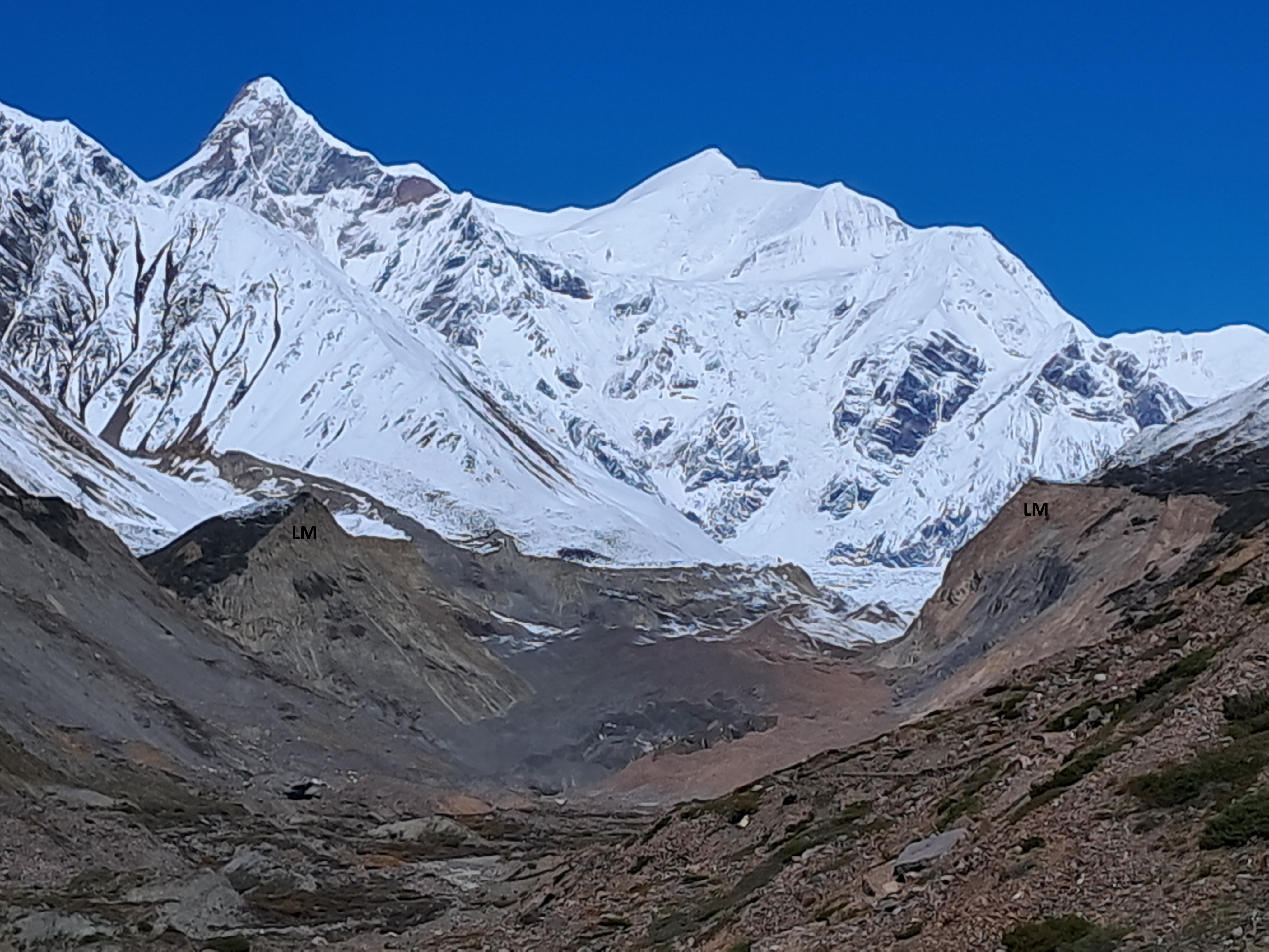
This photo of Milam Glacier shows two beautiful lateral moraines. Notice these have a sharp crest suggesting there are young in age (compare with the LM near Rilkot). They are thought to have formed as recently as the Little Ice Age just a few hundred years ago!
This trail is a gift to geologists. I did a rather quick nine day walk through the main trail and noticed so much interesting geology. Along this path are vestiges of processes that occurred at different times and at different levels of the crust, from rocks that formed in a seething hot metamorphic cauldron that existed during the peak of Himalaya orogeny 20 million years ago, to glacial deposits from the historical Little Ice Age when children skated on the frozen Thames River and much of the northern hemisphere experienced intense cold phases.
A final nod to this fantastic journey. Spectacular leucogranite dikes and sills intruding gneiss on the stretch between Nahardevi and Laspa.
There is much left to explore. I will be surely going there again.