Showing posts with label water resources. Show all posts

Monday, May 12, 2025

Deep Sea Mining, Early Indus Farmers, Indus Basin Dams

Some readings over the past couple of weeks- 

1) The Promise and Risks of Deep-Sea Mining: In late 1988 I visited the National Institute of Oceanography in Goa for a job interview. The buzz in the marine geology labs was about the discovery of manganese nodules on the deep sea bed of the Indian continental shelf. At that time, exploration had just started and the technology was not advanced enough to mine these lumps which contained, besides manganese, other metals like cobalt, nickel, and copper.  The nodule deposits were being looked at as a future resource. 

That day is upon us. Many countries have expressed an interest in mining the deep-sea bed for metals required for the transition away from fossil fuels. Metals concentration of Mn, Co, Ni, and Cu also occurs around hydrothermal vents. Not much is known about the ecology and biodiversity of these remote sites. Most experts feel that mining will result in extensive damage to the sea floor ecosystems and to life in the surrounding water column.

Daisy Chung, Ernest Scheyder, and Clare Trainor describe what is at stake in this beautifully illustrated article published by Reuters. 

2) Indus Valley farming started later than thought, radiocarbon study shows:  Mehrgarh, in Balochistan, Pakistan, was thought to be South Asia's oldest farming settlement going back to around 8000 B.C. New carbon dating of grains using a more robust dating method called Accelerator Mass Spectrometry has revised the date of earliest occupation to around 5200 B.C. Subhra Priyadarshini writes about the implications of this new date with regards to the origins and spread of farming in South Asia and cultural linkages of Mehrgarh to the Indus Civilization. 

3) Water Towers of the Indus Basin: Last month's heinous terrorist attack in Pahalgam, Jammu and Kashmir, India, has refocused attention on the Indus Water Treaty between India and Pakistan and the many hydropower projects that India is planning on the Indus and the Chenab rivers. These rivers provide water security to vast areas of India and Pakistan. 

Despite the importance of these rivers to local livelihoods, hydropower projects are being built without due  consideration being given to the impact dam construction and climate change will have on the Himalaya ecosystem..  

Parineeta Dandekar (story), Abhay Kanvinde (photos), and Michelle Hooper (story map) meticulously document the completed and planned hydropower projects along the Chenab river and point to the lapses in science and environmental governance that have taken place during the project planning process.

Thursday, July 11, 2019

Groundwater Must Be The Focus Of India National Water Policy

India's Water Management Crisis

A piercingly clear essay by Himanshu Thakkar on why India must realign its water resources priorities from big dams and river linking projects to protecting, managing, and regulating ground water.

Just take a look at the numbers:

"Most of the water that India uses today comes from over 30 million wells and tubewells. Irrigation is India’s biggest user of water and over two thirds of irrigated area gets water from groundwater. 85% of rural domestic supply, over 55% of Urban and Industrial water supply comes from groundwater. The graph of % of water in each sub sector coming from groundwater has been going up for at least four decades. In fact, some estimates show that over 90% of additional water India used in last four decades have come from groundwater. It sounds like an immitigable blessing. That’s not how blessings work, unfortunately.

Central Ground Water Board’s data shows that in about 70% of areas, groundwater is depleting and at many places it has exhausted or is on verge of exhaustion. The quality is deteriorating. Warnings have been available for decades now, but the government has done little to address the emerging crisis.

In fact, India’s water resources establishment, lead by the Big dam ideologues at Central Water Commission have ensured that the government do not even acknowledge that groundwater is India’s water lifeline"....

Scary.

Some States have taken initiatives to manage ground water. Maharashtra recently passed the Maharashtra Ground Water Act which provides a framework for management and regulation of ground water. How much diligent enforcement of the rules actually takes place remains to be seen.

Additional Reading:

The Maharashtra Groundwater (Development and Management) Act 2009 - Shashank Deshpande, Deputy Director GSDA.

A Decade Of The Maharashtra Ground Water Legislation: Analysis Of The Implementation Process - Sanjiv Phansalkar and Vivek Kher.

Thursday, August 10, 2017

China Hydraulic Engineering - Yellow River And The Grand Canal

I am reading Philip Ball's excellent book The Water Kingdom: A Secret History Of China. It describes the epic problems of river flow management that China has grappled with over millennia. Enormous floods have always ravaged China. At the site of a large dam at Sanmenxia on the Yellow River is an inscription in honor of the Great Yu ( ~ 2200- 2100 B.C), who as the story goes,  conquered a flood. The inscription says " When the Yellow River is at Peace, the Nation is at Peace". Flood control required enormous civic resources and cooperation and the ability to tame river waters gave political and moral legitimacy to the ruling class.The taming of nature using cooperative people power and as a sign of a strong united society has deep roots in Chinese political thinking.

One particular vexing problem was the very high rates of silt load carried by the Yellow River. A vast area of the Yellow River watershed drains the Loess deposits of north central China. This is a plateau made up of loose friable sand and silt blown in from the Gobi desert of Mongolia. Erosion of Loess fills the river with sediment. There is 300 grams of sediment for every kilogram of Yellow River water giving the river a reddish golden color. Erosion has carved the Loess Plateau in to a landscape of ravines and gorges. The American journalist Edgar Snow in the 1930's described it thus:

" an infinite variety of queer, embattled shapes - hills, like great castles, like ranges torn by some giant hand, leaving  behind the imprint of angry fingers. Fantastic, incredible and sometimes frightening shapes, a world configurated by a mad God - and sometimes a world of strange surrealist beauty. "

High rates of sedimentation meant that the Yellow River bed could aggrade or rise, increasing the risk of the river breaking its banks and flooding the countryside. Dyke building to constraint the river channel began as early as the seventh century B.C. by the state of Qi.

Constant dredging of the Yellow River and the associated tributaries and canal systems ( the Grand Canal) was also required to maintain a channel deep enough for navigation to move armies and grains from south to north.  River channel and canal maintenance acquired a new urgency when Zhu Di known as the Yongle Emperor of the Ming dynasty moved the capital north from Nanjing in the eastern province of Jiansu to Beijing in the early 1400's. The rational was probably to keep the political center closer to the armies amassed on the northern frontier where the Ming faced a threat from the Mongol and Manchurian steppe people. Later in the 1600's, the Manchurians overthrew the Ming and established the Qing Dynasty. Although over time, the Qing assimilated into the larger Han cultural milieu, they felt more at home in the north of the country. That meant the Yellow River and the Grand Canal system had to kept in top navigable order.

Desperation to unclog  the river channel spurred technological innovation. 

An extract:

Removing silt from the Yellow River demanded some impressive technology, not to mention serious organization. The Song government set up a Yellow River Dredging Commission in 1073 which began to deploy boats equipped with dredging tools. The vividly named  "iron dragon-claw silt dispersing machine" was a great rake pulled along the riverbed to agitate the silt and return it to the flow. This principle was extended with the 'river-deepening harrow', a 2.5 metre-long rotating beam fitted with iron spikes, like a thresher for riverine mud. The Ming imperial censor Chen Bangke introduced new techniques in the late sixteenth century, such as wooden machines set rolling and vibrating by the current to constantly stir up the sediment. In the dry season Chen proposed simply digging out the silt manually.

The Ming official Pan Jixun in 1565 or so came up with a solution that has made him one of China's water heroes. He pointed out that if one confines the water flow to a narrow channel, it will have enough strength to scour the sediment off the river bed. There would be minimal need for laborious manual dredging. He may have borrowed the  idea from a Confucian text of the Han era (~200 B.C - 220 A.D) called Zhou li (Rites of Zhou) which stated "A good canal is scoured by its own water". 

Chinese philosophical tradition impacted river management strategies. Daoists argued that the river be given room to spread and build wide floodplains in concert with the principle of wu wei which could be read to mean "do nothing" or "having a yielding attitude".  Confucians on the other hand wanted the river to be managed by human  engineering and recommended the construction of high dykes to keep the river channel narrow and constrained.

Joseph Needham, the noted historian of China writes that 'during twenty centuries the two schools contented'.. 'and neither proved wholly successful'.

Highly Recommended.

Friday, July 28, 2017

The Lost Rivers Of The Harappan Civilization- Remote Sensing Analysis

A lot of ink has been spent of this topic, both in the scientific literature as well as in popular books about the Harappan Civilization. The focus of many of these efforts has been on locating the "Vedic Saraswati", a river mentioned in the Rig -Ved. It is described as occupying the region between the Yamuna and the Sutlej and has been identified by many workers as the present day Ghaggar-Hakra.

Settlements of the Harappan Civilization were spread out over quite a large area in northwest India. Hence, it is necessary to map in detail the broader once existing hydrologic networks to assess the relationship between settlements and patterns of water availability and water use. This study uses remote sensing data and image processing techniques to unearth some of the buried paleo-river networks of this region of northwest India.

Twenty eight years of Landsat 5 imagery totaling 1711 multi-spectral images was bulk processed. This use of data covering multiple dates in a year allowed the investigators to reduce visibility issues related to shifting land use and cultivation, changing moisture patterns and variable cloud cover. 8000 km of paleo-river channels were mapped, some identified in previous studies, but many recognized anew.

The paper describes the various image processing techniques used to tease out the spectral signatures of the buried rivers. Don't be alarmed by words like Normalized Difference Vegetation Seasonality Index (NDVSI), Principal Component Analysis and the Tasselled Cap Transform.  One can understand the final interpretations without getting into the details of these techniques. Let me give a brief idea though.

These are techniques has increase the contrast between vegetation, soils with different moisture levels and bare terrain. For example, due to stronger water flow the river channel itself and the levees it builds contain coarser sediment as compared with the adjoining floodplains. These coarser sediment contain less organic matter and are less fertile. Less vegetation grows on the buried channels and levees than on the more fertile fine grained floodplain sediment. This contrast shows up well on data processed using NDVSI which essentially maps the vigor of vegetation. This technique was useful in delineating channels in the northern part of the study area.

The southeast part of the study area is more arid and has less changes in vegetation across the landscape. Here, the Tasselled Cap Transform was more useful in identifying river channels. This techniques organizes the spectral information into several (usually three) main axis or bands of information. One axis contains data variability of reflectance of bare terrain (mineral mixtures). The second contains variability in greeness (vegetation), and the third contains variability of wetness (water and soil moisture). Again, to give an example, this southeast region is fed by rivers draining Aravalli limestones. The calcium carbonate leached away from the rock is precipitated along river channels as a chalky mineral deposit. Buried channels show up as ribbons of  bright reflectance in  the Tasseled Cap Transform brightness band. Imagery of the dry months shows these channels more clearly, since in the wet months, increased soil moisture reduces the contrast of calcium carbonate rich sediment.

A judicious use of such techniques thus enabled the researchers to identify buried networks with different vegetation, soil moisture and mineral brightness properties. 

A map of the interpreted buried rivers is posted below.


Source: Hector A. Orengo and Cameron A. Petrie 2017

Of importance is a critique of some previous studies which attempted to highlight the spatial relationship between river channels and archaeological sites (emphasis mine):

The data provided by these analyses are also important in contextualising previous studies in which palaeo-rivers have been dated using the distribution of known archaeological sites. Notwithstanding the positional accuracy of these locations (see [10,63,64]), which would severely hamper their use for validation purposes, the results for the northern sector of the study area (Figure 3) suggest that proximity to the river might not be a good indication of contemporaneity as the fields close to the river channel might not have been the most productive in agricultural terms. Sites with an agricultural orientation might have preferred to occupy elevations above flooding level in the finer sediment accumulation area. Flooding events and changing river courses could also have had an important effect in the preservation of archaeological sites eroding and burying those that were locatedin the path of new courses or in their sediment accumulation areas.

In addition to these factors, the scale at which these correlations between specific palaeo-channels and settlement locations have usually been published (e.g., [30] (pp. 359–387), [31] (Figure 4.2)]) do not allow the accurate correlation between the two elements. The use of large area (small scale in a geographic sense) site distribution maps for these correlations results in a visual association between the shape of the palaeo-river and the line formed by the grouping of sites, but at these scales the sites could be aligned to a number of palaeo-channels given the number of rivers and the parallel morphology of the drainage in the Sutlej-Yamuna interfluve revealed here. This analysis thus suggests that at these scales it is not possible to co-relate lineal distribution of archaeological sites to any particular palaeo-river that we have documented. The results from previous studies reconstructing the chronology of the hydrological system using the position of archaeological sites and vice versa(e.g., [24,25], [30] (pp. 359–384), and [31]) are, therefore, considered unreliable.


..and

Given the complexity of the hydrological system, the variety in the climatic and weather system of this region, and the diversity of ways that ancient populations are likely to have obtained water, it is unwise to use the date of occupation at specific settlements to date when specific channels carried water. It is essential to date the different palaeo-courses independently to properly reconstruct the evolution of hydrological networks over long periods. The chronologically consistent reconstruction of this palaeo-river network would allow the testing of different hypothetical scenarios of water availability through the use of network analysis in combination to hydrological analysis.

Interesting work. Open Access.

Tuesday, June 13, 2017

Books: Origins Of Complexity ; China Water History

These just arrived.

Extract:

I hope to persuade you that energy is central to evolution, that we can only understand the properties of life if we bring energy into the equation..... I want to show you that the origin of life was driven by energy flux, that proton gradients were central to the emergence of cells, and that their use constrained the structure of both bacteria and archaea. I want to demonstrate that these constraints dominated the later evolution of cells, keeping the bacteria and archaea forever simple in morphology, despite their biochemical virtuosity. I want to prove that a rare event, an endosymbiosis in which one bacterium got inside an archaeon, broke those constraints, enabling the evolution of vastly more complex cells. .....Finally, I want to convince you that thinking in these energetic terms allows us to predict aspects of our own biology, notably a deep evolutionary trade-off between fertility and fitness in youth, on the one hand, and ageing and disease on the other.

The last book I read on the evolution of complexity was Mark Ridley's The Cooperative Gene which described the many evolutionary inventions that suppress genomic conflict and make multicellular bodies workable. Nike Lane writes at a more fundamental level of the energy currency of the cell. Feeling very excited about this book. I am sure to learn a lot.

Extract:

But the ubiquitous and ambivalent relationship that the Chinese people have had with water has made it a powerful and versatile metaphor for philosophical thought and artistic expression, and its political connotations can be subverted and manipulated in subtle ways for the purposes and protest and dissent. These meanings of water are more than metaphorical. Because the lives of everyday folk has always depended on water, the river and canals mediate their relationship to the state. Water -too much of it,or too little - has incited the people to rise up and overthrow their governments and emperors. Burgeoning economic growth now places unprecedented pressure on the integrity and sometimes the very existence of China's waterways and lakes. Not only can China's leaders ill afford to ignore this potential brake on economic growth, but the environmental problems are leading to more political pluralism in a nominally one party state.

Sweeping... from the Qin Dynasty (200 B.C.) to the present..

Wednesday, August 28, 2013

The Aquifer Underneath My House

... is very prolific.


The photo above taken in March 2012 is of an excavation for a building about half a kilometer away from my home in Pune, India. The developer struck water at around 20 feet below the surface. Water began gushing out of sheet cracks in the basalt rock. Within a couple of days the water level had risen to just a few feet below the surface and then stabilized.

The water level you see in the picture is not the water table but the potentiometric surface. The developer had punctured a confined aquifer. Water in this type of aquifer is under hydrostatic pressure. The puncture or hole is this case creates a pressure gradient and water flowed from the aquifer (high pressure) into the hole (low pressure). It rose until the water pressure at the bottom of the hole equaled the water pressure in the aquifer at which point water stopped flowing out of the aquifer and hence stopped rising in the well /excavation.

In the picture below the red arrows point to the sheet cracks from which groundwater is seeping out.

Tuesday, December 11, 2012

Summary Of India Draft National Water Policy

How India manages its water resources is an issue of paramount importance. S. Ramesh at InfoChange.org gives an excellent summary of the National Water Policy and its merits and demerits.

The draft National Water Policy has gone into two revisions, first in May 2012 and then again in July, after being tabled in January when protests were made about the policy treating water as an economic good, and favouring privatisation. Still, the soul of the draft remains intact except for a few points.

There is every likelihood that water will become a highly rationed commodity in the future. We will have to pay for any excess water we use after our basic domestic, sanitation and agriculture requirements have been met. This makes a national-level legal framework to control water use and prevent inter-state, intra-state and regional water conflicts absolutely imperative.


Statistics on India's water availability are summed up in one paragraph and a table gives projected increase in water demand for various sectors. One quirky detail... Inland navigation which has no demand in 1988 shoots up to 15 bcm (billion cubic meters) in 2050! Is that due to the building of large canals to transfer water from one river basin to another? (I haven't read the report by the National Commission for Integrated Water Resources Development  Plan 1999 from which this data was taken). Inter basin transfer of water or river linking as it is also known is often being presented as one solution for supplying southern Indian water "deficit" basins with "excess" water from mostly northern Himalayan rivers, although there are more local versions of the plan too. The problem off course is to get states to agree that they have excess water to part with, along with a host of other issues involving resettlement of displaced people and energy and ecological costs.

Quite a useful overview. And there are more interesting articles on India's water resources and the debates over privatization of water on the InfoChangeIndia website.

Monday, November 19, 2012

Chinatown And Water Law On Generation Anthropocene

No.. no.. Jack Nicholson didn't show up on Gen. Anthropocene to revisit his great role in the movie Chinatown. In that movie, detective J.J.Gittes played by Nicholson uncovers a shady plan set in the early 1900's  to monopolize the water resources of Owen's Valley and to divert that water to the growing city of Los Angeles.

Buzz Thompson who is an expert in environmental and natural resources law and policy has a personal connection with California's dodgy water history as he recounts how his grandfather's farm was bought over by the city of Los Angeles in the early 1920's using a local farmer as a front and then letting the farm lay fallow as it diverted water for urban use. 

He also gives a tutorial on the different water use doctrines prevalent in the U.S as he explains the differences between the riparian water use doctrine of the eastern part of the U.S. versus the prior appropriation water use doctrine common in the west and also talks about how enforcement of water law has generally failed in the U.S. Another important topic covered is the economics of water use especially in the context of water recycling.

 Excellent conversation from Gen Anthropocene.

Monday, May 30, 2011

What The Last Man On The Moon Picked Up

Harrison Schmitt was the last man on the moon and he collected soil samples.  These languished in a drawer for 40 years. Recently Erik Hauri,  a staff scientist in geochemistry at the Carnegie Institute for Science and his student Tom Weinreich from Brown University examined these samples and found that tiny moon crystals contained inclusions of magma. Using an ion microprobe they were able to measure the amount of water in these magma inclusions and make an estimate of how much water may be present in the interior of the moon - trapped in such crystals.

The answer is a lot... about the amount of water in the Mediterranean sea... but it is dispersed and there is no efficient way to collect it in useful amounts.  According to Prof. Hauri the water in the lunar magma inclusions is in amounts similar to water expected in the Earth's upper mantle.

On Science Friday Ira Flatow discusses this discovery with Erik Hauri and what it means for our understanding of the evolution of the earth and moon system and specifically the implications for the origin of water on early earth and the moon.

The presence of water ice in craters near the north and south poles of the moon was known from recent remote sensing sorties by spacecraft from U.S  and India. Erik Hauri speculates on how this water in the lunar craters came to be.. is it of very ancient volcanic origin, sourced ultimately from the magma he measured?.. that water may be billions of years old since volcanism was present only in the very early history of the moon.. or is that water a later addition, plastered on to the surface of the moon by comets and meteorites?..

There is still much to learn about lunar evolution.

Listen / Transcript

Tuesday, April 12, 2011

Every Pot Of Coffee You Make Is Dinosaur Pee

I wouldn't have come up with a post title that weird...

but I quote from Charles Fishman's interview with Terry Gross on Fresh Air. Mr Fishman is the author of The Big Thirst: The Secret Life and Turbulent Future of Water and he reminds us about the origin, nature and the journey of water on earth -

Mr. FISHMAN: And all the water on Earth was actually formed in space, in interstellar gas clouds. And it was delivered here when the Earth was formed, or shortly thereafter, in exactly the form it's in.

So all the water on Earth - the water in your Evian bottle, the water in your glass of water, the water you use to boil a pot of spaghetti - all that water is 4.3 or 4.4 billion years old. No water's being created on Earth. No water's being destroyed on Earth. And what that means is the whole debate about reusing wastewater is kind of silly, because all the water we've got right now has been used over and over again. Every drink of water you take, every pot of coffee you make is dinosaur pee, because it's all been through the kidneys of a Tyrannosaurus Rex or an Apatosaurus many, many times, because all the water we have is all the water we have ever had.

And to me, that's actually good news. Water is incredibly resilient. It's unlike fuel or other natural resources. It can be used over and over and over again, and it emerges - except for needing to be cleaned, ready to use again - exactly as water.

That's thinking of recycling well beyond the usual discussions of wash-basin to your lawn. He talks about that too and a lot more in a quite informative talk.

Did you know why the launch pad of the space shuttle is covered in a cascade of water during launch?

And you would naturally think that that has something to do with the heat and the flame. In fact, the water on the launch pad of a space shuttle launch is a sound-dampening mechanism for the space shuttle. The space shuttle is so loud that the sound would ricochet off the concrete and metal launch pad and tear the space shuttle apart, literally destroy it, before it cleared the pad without the water.

Listen / Transcript.

Thursday, December 2, 2010

United States Water Usage Maps Through Geocommons

Just a pointer that GeoCommons, a public domain web mapping application by Fortiusone Inc has a growing collection of geology and natural resources data.

I've been having fun last couple of days downloading some U.S. water use datasets, importing them in Manifold GIS, making them map ready and then uploading them back on Geocommons. Using the Map Maker I have then presented the results in a couple of maps.

The first shows the total ground water usage by state in millions of gallons per day (colored states) and also ground water use as percent of total water use (graduated dots). Orange blocks as urban centres with population greater than fifty thousand. You can see the east west divide in water use type. The east relies a lot more on surface water. The central and western areas along with Florida in the south east rely on ground water more than the eastern states. The importance of the Ogallala or High Plains Aquifer is clearly seen in the central states as is the importance of the Central Valley Aquifer in California.


View full map

You can drill down and bring out other dimensions of this data. For example in the map below I've plotted one of these dimensions, the ground water usage for irrigation in millions of gallons per day in the High Plains counties. The High Plains Aquifer is outlined.


View full map

This is not a full "cloud GIS" yet in terms of users borrowing or leasing the full range of GIS functionality from a remote computer. I had to follow a hybrid approach as did other data donors in terms of using a personal GIS to process the data to certain specifications before uploading it to this online service. Still such services are gaining importance and functionality and they give users who don't own software an inexpensive tool to actively engage with spatial data.

Monday, June 14, 2010

Sinking Deeper And Deeper For Groundwater In Pune

This is a sight becoming common in Pune.


A drilling rig is often the first order of business for many new constructions on commercial and residential premises. It reflects both an increased consumption of water due to affluent lifestyles and a growing uncertainty about water security often due to lack of piped water supply especially in the suburbs and despite claims from the Pune Municipal Corporation that surface water reservoirs have enough capacity to provide for future population growth and increased use.

I guess people want to ensure that they have a water supply under their control in case of future inability of the city to provide them with piped water. I talked recently with a geologist with years of experience in the groundwater situation in Pune and I heard the same ominous story that is reverberating all over India.

The deeper aquifer in Pune which means drilling to depths of 150-200 feet seems to be experiencing overdraft as unregulated bore-wells extract more than natural recharge. The city is trying to address the problem by proposing that it will limit the number of bore-wells based on surveys of aquifer capacity. This kind of aggregate limit however will not regulate current and future use by individual wells already in operation. Indian groundwater law allows the owner of a property unlimited use of the groundwater and increased reliance on groundwater in the future will keep depleting the resource if not managed scientifically.

And therein lies the problem because just how much water lies underneath is at best only sketchily understood. Any blanket limit going by watersheds  imposed on extraction makes little sense because the deeper aquifers in Deccan basalts are not congruent with the surface water contours. They show extreme laterally variability and are compartmentalized. So for proper groundwater management the underlying aquifers need to be mapped, monitored and a scientific database on aquifer capacity needs to be built before any allocation plan that is sustainable is finalized.

Besides understanding the limits of extraction, just how the city is going to regulate individual use of groundwater remains a thorny issue. There is extreme reluctance to price the use of groundwater by metering bore-wells. The reasons are manifold. It will be an "enforcement headache" (read we are too lazy) is one excuse I have heard. Besides, there is a cultural tendency in India to look at groundwater as a free resource. The focus for long on groundwater use as been on rural consumption for agriculture. Making farmers pay a price for electricity and water is considered political Harakiri in India. So politicians keep tip-toeing around making any serious amendments to groundwater law.

Indian cities however are growing and reliance on groundwater by urban users is bound to increase. There needs to be a sensible re-look at groundwater laws for the urban consumer. Water allocation for well owners based on the aquifer capacity, the need to limit new well permits, mandating artificial recharge structures to augment refilling, and getting urban consumers to pay for the water they are pulling out of the aquifer are all ideas that need to be debated and thrashed out if we want to move towards a more sustainable use of this resource.

Tuesday, January 5, 2010

Hydrologist Will Be One Of Top Careers In 2010

US News and World Report has a listing of best science and technology careers and hydrologists figures among the top.

Job opportunities should be plentiful for environmental scientists and especially for hydrologists. There were 8,100 hydrologist jobs in 2008, and employment should grow more than 18 percent by 2018. The government has stepped up environmental regulations and has begun cleaning up contaminated and hazardous waste sites—all efforts that increase the need for hydrological research. Competition for openings is limited by the small number of universities and colleges that offer degrees in hydrology.

The figures are for the United States but I would predict that a career to do with water holds a lot of promise in any country. This is not a new observation. Sometime back Science Careers carried a lengthy article on hydrogeology careers and called them "recession proof".

Population pressures, water reallocation challenges between rural and urban consumers, climate change and past mismanagement of water resources means there will be plenty of work for hydrologists and hydrogeologists for decades to come.

Wednesday, October 14, 2009

A Government Scientist Speaks Out On Flood Management

You don't hear many Indian Government scientists opining about science, policy, the environment, civic criticism...well you get the picture.

There are restraints....to put it politely.

But Chetan Pandit of the Central Water Commission has broken the shackles and in the October issue of Current Science comes out sparring strongly against - in his opinion - the woolly headed arguments of the environmental community  and the media on the subject of big dams and flood control.

He puts forth several fallacies and myths regarding dams and flood control and argues very well that big dams have served as effective flood managers.

And I had to chuckle at this:

We Indians seem to be particularly susceptible to this ‘romancing with the past’. Everything, be it water management, or agriculture, Ayurveda, mathematics, literature, astrology, etc., we like to believe that in India all learning had reached its peak in some distant past, and the best thing for us to do is, to continue to do what our ancestor’s did. And this is given a lofty name ‘wisdom of the centuries’.

You may be inclined to view big dams as destroyers of forests and biodiversity and so on but Chetan Pandit has made some good points about the intellectual environment in which debates on these issues take place and are presented to the public in India. One of the most important points he makes is that many people who get involved in criticizing government projects are numerically challenged. Arguments are high on the emotional quotient but there is little quantitative analysis of data to go with it.

I am sure not all environmentalists are so mathematically naive, nor should every developmental project be reduced to just numbers. But this is a government scientists view. When presented with a  rare opportunity to speak out he doesn't restraint himself.

Read the article here.

Update: Chetan Pandit via an email to me wants to clarify:

I never said that those criticizing government projects are “numerically challenged”, or mathematically naïve, etc. Even a high school student would be able to import the data on flood affected area into a spread sheet and plot a graph to see whether or not there is any increasing trend. What happens is, if they do that their argument will collapse, the numbers do not favour them, they know it, and therefore they have to willfully ignore the numbers. Which is why I wouldn’t describe the environment in which debate takes place as “intellectual”. It is pseudo-intellectual.

Chetan Pandit

Sure, he didn't use the words numerically challenged and mathematically naive. Those are my words but he does imply this. For example he writes about noted anti-dam activist Shripad Dharmadhikary -

In his exhaustive critique of the Bhakra dam, noted anti-dam activist Shripad Dharmadhikary writes, ‘Even after the Sutluj flows were augmented by the transfer of Beas water into the Bhakra reservoir, the reservoir has not filled up in most of the years’4. This was probably intended as a critical comment on filling of the Bhakra reservoir. But its implication, which probably escaped Dharmadhikary, is – Bhakra is very successful in flood control. In the years, the dam did not even fill; it is obvious that all the floods were absorbed 100%. And this, despite transfer of a substantial quantity of water from Beas to Sutlej through the Beas–Sutlej link.

But its implication, which probably escaped Dharmadhikary,...

So I read this as meaning Dharmadhikary did not understand the topic well enough. It certainly doesn't read as meaning that Dharmadhikary churned out the numbers, didn't like what he saw and then ignored the finding.

Tuesday, September 15, 2009

Imagining An Underground Venice In The American Southwest

From BldgBlog post Hexagonal Hydropolis I went to the source Matsys where Andrew Kudless has created a futuristic and imaginative vision of a subterranean urban landscape in a dessicated American southwest.

The concept and architecture is stunning. Vast underground water reservoirs are connected to the cityscape via canals which also are the means of transport.


Image; Sietch Nevada / renderings by Nenad Katic

This is a grand and impressive outlook and I keep thinking on another track when I come across the many futuristic adaptive scenarios that are being proposed as responses to changing climate and resulting changes to our living space. The problems are varied, deep underground water storage, deep underground CO2 storage, coastal erosion, understanding changing river dynamics in the north Indian plains as glaciers shrink, exploring for uranium to boost nuclear energy....geology and geologists will play an increasingly important role as we explore and implement solutions to meet this challenge.

Friday, August 21, 2009

North India Facing Groundwater Calamity

Nature magazine has a great video of North India heading towards a water calamity. Groundwater is dropping more than 1 foot per year on average and over the last 6 years about 109 cubic km of water has been pulled out of aquifers underlying northwestern plains of India.
Recent measurements of water loss were done by twin satellites called GRACE – NASA's Gravity Recovery and Climate Experiment. These satellite orbit the earth at a set distance from each other and instead of taking measurements of objects directly below, they look at each other and measure changes in orbit due to variations in the pull of gravity.

The result is summarized below. Red areas depict areas of groundwater loss and blue areas of groundwater gain.


Although striking, the measurements of the Punjab area should not come as a big surprise. Depletion of the groundwater table has been known to be taking place for many years but presenting the results in such a pictorial form and as volumes does make one sit up.
My attention however was drawn to the blue areas in the central parts of the country. They show a groundwater gain. This has been interpreted as due to above average rainfall for the last several years. No doubt that has played a role, but that hides a more general pattern.
I've written about this region before and the link between groundwater accessibility, use and farmer poverty.
Population densities of this dry interior region are less than the northern plains. Even so, groundwater is an underexploited resource per capita as compared with the northern plains of the country. Geology does play a big part in it. The terrain is all hard rock aquifers which are heterogeneous and compartmentalized and finding groundwater is not easy. Its also very expensive to dig a dug well or drill a bore well so many poor farmers end up relying on rains for their water needs. Vast tracts of this region are not supplied by surface irrigation canals and groundwater must be made more accessible if the widespread problem of reliable water supply to farmers is to be solved.
I want to put up this figure again to emphasize how important groundwater is to the Indian agricultural economy.

More than a decade on the importance of groundwater in agriculture holds and is growing. But till now groundwater has been seen as a resource to be extracted without giving any thought to the long term viability of such an approach. We need to change that mindset and steer it towards one that recognizes that just finding groundwater is not going to be enough. The sensible scientific management of the resource is just as crucial.
Maybe we still don't get it. Sadanand who blogs at Chintan has a post that highlights how we think about water and the solutions to scarcity. Irrigation canals and dams serve only 15% of arable land in India but that's what the apparent solution is in the minds of government and media alike. Groundwater which serves the rest and which will become even more important in the context of climate change is still being neglected.

Friday, July 31, 2009

Damming India - Eminent Domain At Its Worst

More dams, more forests submerged and villages displaced.
All done with utter contempt for the people who will have to give up their livelihoods and social and cultural bonds and ways of life.
Shripad Dharmadhikari documents another misguided and utterly ill thought out dam project in Himachal Pradesh which is being built to make up for the water wastage of Delhi city. Land is being acquired from villages even before the project has been cleared by relevant authorities under the "urgency" clause. This is a particularly nasty form of land acquisition - eminent domain- which curtails the right of land owners to object to the acquisition process.
Think about what is happening. This project still does not have the clearance of the Ministry of Environment and Forests but the process of acquiring land at unjust prices has already started!
We boast so often of becoming a world power and a tier one nation. But bullying one's own people into submission is not development and not a sign of a mature civilization.

Monday, June 29, 2009

Water Harvesting: Legal At Last In Colorado

This piece about water harvesting and conservation in NYTimes caught my eye:

“I was so willing to go to jail for catching water on my roof and watering my garden,” said Tom Bartels, a video producer here in southwestern Colorado, who has been illegally watering his vegetables and fruit trees from tanks attached to his gutters. “But now I’m not a criminal.”

I remember reading Marc Reisner's epic book Cadillac Desert which described the complex water regulations of the U.S. southwest. Every drop is owned by some state or water district or the other before it falls to the ground. But water allocation was apparently done during an unusual wet period and without anticipating the massive growth of population in the deserts. Climate change which is making the southwest drier and population pressures have increasingly made these allocations look unfair. At some point if there is just no more water then no matter how you try divvy up the pie someone is going to come up empty.

In India too damming streams and diverting water that would inhibit natural flow as defined by the local government agency used to be frowned upon and the law has always been unclear about the ownership of water harvesting structures and water. Indeed the state reserved the right to send you notice if it felt that the structures being built were unsafe or that blocking too much water would lead to a shortfall in the government canal and dam system allocations. But water harvesting is done at every level ( see this article) from recharging a well in the backyard to community efforts that have rejuvenated landscapes. The local water authorities don't always like it but don't prosecute because they really can't provide an alternative. Village communities and NGO's get massive grants for water harvesting from funding agencies for an activity that the government is finally realizing is the need of the hour. Many state governments are modifying their Command Area and Irrigation Acts to give farmers and local communities more rights to own and manage local water resources.

It usually takes a long time to change laws and regulations. Sometimes people's behavior and actions may act as a signal that times have changed and the rules must change along with it.

Monday, April 27, 2009

Articles On The Groundwater Situation In India

Just a follow up on last week's post on geology, groundwater and climate change. I've been reading a couple of interesting articles on the groundwater situation in India.

The Socio-Ecology of Groundwater in India- International Water Management Institute- Tata Water Policy Program

Energy–Irrigation Nexus in South Asia: Improving Groundwater Conservation and Power Sector Viability - International Water Management Institute- Tata Water Policy Program

My posts on groundwater have a predictable angle of how geology influences the availability and use of groundwater. But if you are interested in going more in depth about the socio-economic and political angle and understanding the role of groundwater in Indian agriculture, farmer livelihoods and the real and potential damage to groundwater resources from rampant mismanagement of the resource then read these articles. The articles also point to the needed policy initiatives for sustainable management of groundwater.

The figure below encapsulates the importance of groundwater to the agricultural economy of India

Change in the contribution of groundwater and surface-water irrigation to agricultural GDP in India

Source: The Socio-Ecology of Groundwater in India

Wednesday, April 22, 2009

Geology Will Be Central To India's Climate Change Response

A friend returned from Australia with stories of water rationing in Melbourne and Adelaide. Can't water lawns and wash cars. That would invite fines from the city. Coincidentally, national geographic magazine has a feature on Australia's big dry, a prolonged drought that has decimated farming communities in the Murray Darling basin and forced farmers to sell century old farms and move to cities in search of work.

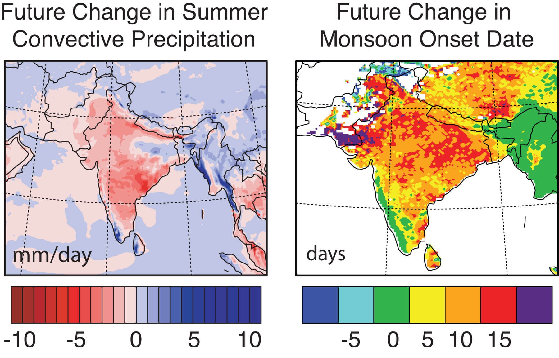
As always I want to steer the conversation to what is happening in India. A recent regional finer grained climate model from researchers at Purdue University confirms what global climate models have been telling us for some time. That monsoon patterns will change both in the timing of the advent of rains and in the amount of precipitation. The map below shows the across-country expected changes in both these parameters.

Source: Purdue

The basic take away lessons from these studies are that: 1) the country will get hotter 2) rainfall pattern will be more unpredictable 3) rains will be concentrated in shorter more intense bursts 4) periods of drought will last longer 5) overall, regions which experience less rainfall can expect even less rainfall, those that experience a lot of rain can expect little change or an increase in rain.

I turn again to the National Water Mission, one of the eight focus areas in the National Action Plan for Climate Change (15 mb) It does recognize that water availability and rainfall will vary region by region and proposes a host of measures in its draft report that includes enhancement and better management of groundwater resources as well as surface water resources.

That is fine talk but will the resource allocation and effort match the current pattern of water use? Himanshu Thakkar in a detailed critique of the National Action Plan For Climate Change is pessimistic about any fundamental changes taking place in the way the government thinks about water resources. Yet, today over two thirds of arable lands in India are irrigated by groundwater and over 85% of rural water supply and about 50% of urban and industrial water supply comes from groundwater sources. Historically though it is surface water that has received more attention and funding. Our government planners have always been obsessed with mega infra-structure water projects.

Despite hundreds of kilometers of canals, surface water irrigation helps less than 15% of Indian farmlands. The majority rely on direct rain and groundwater supported by about 20 million irrigation wells. It is the small landholders and marginal farmers who benefit most from groundwater. From 1970 to 1995 marginal farms increased their groundwater irrigated areas by 400 percent as compared with just 1 percent increase for large farms, which seem to rely more on canal irrigation.

Looking at the above numbers, at how the water resources pie is divvied up by users, it is groundwater that should be the priority of the National Water Mission. Its not just the lessons from the past regarding the inadequacy of big dams /canals that should guide a shift in focus, but also the realization that climate change will render these systems even more ineffective in the future. Shorter more intense bursts of rain would mean more vigorous surface flow and soil erosion. This would mean increased rates of siltation of canals and dams and a rapid decrease in storage capacity. And a hotter India would mean increased evaporative losses from larger surface reservoirs.

Storing water underground minimizes this loss of water through decreased capacity and evaporation. But a groundwater based strategy faces its own challenges. I am placing below a map of aquifers of India. Compare the spatial distribution of aquifer types with the climate model above.


Source: WHYMAP

Over large tracts of the country, areas that are projected to receive less rainfall in the future are underlain by hydrogeologically complex aquifers!

These are the Precambrian shield areas of south and central India and the Deccan volcanics of central India. In alluvial aquifers which underlie the Indo-Gangetic plains water is stored between sediment grains. There is not a whole lot of spatial variability in water storage properties and although the depth to water table can vary, it is uniform and predictable over large areas. The situation changes in hard rock terrains. Water in these types of crystalline rocks is stored and flows along very restricted zones of permeability. These can be tricky to map. Aquifers are spatially heterogeneous and compartmentalized. Shorter bursts of rain would mean greater surface flow and less seepage underground. That would mean geo-engineering solutions to enhance recharge through careful assessment of recharge zones and use of the 11 million or so dug wells that access aquifers in these hard rock terrains.

If groundwater is to take center stage in our adaptation to climate change geological knowledge will have to play an increasingly important role in how this resource is managed and exploited.

So far aquifer "management" in the few instances it is actually practiced in this country is largely driven by heuristics. But with climate changing and conditions becoming more unpredictable, "this is the way we have done it since our great grandfathers time" may not produce the best results. A more successful approach would be one which uses a more rigorous quantitative understanding of the groundwater systems.

What is the lateral extent and storage capacity of the underlying aquifer? How much water can be sustainably withdrawn from aquifers with particular physical properties? Will certain types of aquifers support certain crop types? We need to improve and enlarge the science programs studying groundwater. Geology comes into the picture in a big way, not just to find groundwater but to manage it as well. That means larger and denser monitoring networks and mathematically inclined geologists to make sense of the incoming data. Geo-engineering solutions to enhance recharge and storage need to be put in place. The increasingly sophisticated understanding of the groundwater systems will have to be explained to the farmers. For that a gentler more transparent interface between geologists and the groundwater user community needs to evolve.

I am not saying anything terribly original here, but scientific management of groundwater is the most economical and environmentally least destructive solution for providing water security to a majority of our farmers.

Now, how do you make the National Water Mission listen?