Showing posts with label kumaon. Show all posts

Saturday, November 29, 2025

Landscapes: PIndari Glacier Trail

Every time I am dragging myself back on the last day of a tiring trek in the Himalaya, I curse and swear that I’ll never do this again. And yet, here I am, exploring the Pindari Glacier area in the Kumaon. What a beauty!!

The trail begins at village Khati. This is also the starting point for the trek to Sunderdunga Glacier which I managed to do last year. A third trail to Kafni Glacier also starts here. Landslides has made a section of that trail inaccessible for the time being.  Pindari Glacier was a favorite recreation site for colonial administrators during the Raj. As a result, two comfortable guest houses were built along the trail. The first one is at Dwali, a 12 km walk from Khati. The next hut is a further 7 km walk at Phurkiya. A cot and a warm meal is available at both places. The caretaker lives there from April to late November. 

My preference has been to go to these Uttarakhand trails in early mid November. I love that season with its cold weather, clear views, and the occasional snow flurry. And the last day walk from Phurkiya camp to the glacier is breathtaking (it was 6 below zero when we started!!).

Here are some pics of the landscapes along the trail. 

A walk through the forest with a peek of the snow ridges.

Splashes of  yellow in a steep valley.

River terraces.  

T0 is the old river bed. It is now colonized by vegetation. The river then incised or cut down into the sediment creating a bench or a terrace clinging to the valley side. There was a second phase of sediment accumulating on the new river bed followed by another incision, creating the T1 terrace at a lower level. I love to observe these changing behavior of rivers as I walk along. 

Organic red pigments have colored these boulders in the Pindari river bed.  


Dwali campsite which you get to by crossing this rickety wooden bridge over a fast flowing river.  


Ahead of Phurkiya camp, walking towards the glacier, the valley widens, opening up some great views. 


Pindari Glacier, still about 3 km walk away.  


At "Zero Point", standing on a narrow lateral moraine!  


Listen to an afternoon rain shower in a High Himalaya valley, near Phurkiya campsite. 


Above the tree line. These glacial valleys are harsh, desolate, and beautiful.


 Until next time...

Friday, May 30, 2025

Shrinking Panchachuli Glacier

Over the past few years I have been regularly visiting the Panchachuli Glacier in the Kumaon Himalaya. Accompanying me are a group of geology enthusiasts from all walks of life. This is an outreach effort I have undertaken in collaboration with Deep Dive India. 

Every time I make it a point to walk to the glacier snout where the river Dhauliganga emerges from an ice cave. Every time my experience of approaching the glacial terminus is different. The Panchachuli Glacier is a shape shifter. I have to walk a little longer each time to reach the snout, negotiating the changing configuration of rubble mounds and streams.

I thought I would document the retreat of the snout over time using field photos from my visits beginning year 2017 and supplemented by Google Earth imagery going back to the year 2000. I won't keep you in suspense. The glacier snout has retreated by about 1 kilometer in the last 25 years. That is by 40 meters per year. But the rate has varied, with an acceleration in the past 8 years.

Let's begin with a synoptic view of the glacial valley.


The walk begins at village Dantu. It is about 6 kilometers to the present position of the snout. The red lines are edges of old lateral moraines. They are stable features and are easily recognizable in the satellite images. They are my fixed marker posts against which I will track the changing position of the snout. Distance to the snout in all images is estimated from marker post A. 

Year 2000- Google Earth Imagery.

Notice the curvilinear cracks (white arrow) near the snout. The glacier retreats by slices of ices cleaving off these cracks. Between the two marker posts is a smaller glacial valley. Semicircular depressions and ponds have formed on the glacier surface due to thawing of the ice. The distance to the snout from A is about 1.3 kilometers.

Year 2012- Google Earth Imagery.


Distance to the snout from marker post A is 840 meters indicating a retreat of 460 meters in 12 years, averaging about 38 meters per year. The smaller valley still has a fair amount of ice accumulation.   

Year 2017- Field Photo.

This was taken during my first visit from a high vantage point along the trail to "Zero Point", a popular trekking spot along an old lateral moraine. 

Year 2017- Google Earth Imagery.

Between 2012 and 2017, the snout has retreated a further 120 meters, an average retreat of about 26 meters per year. The frontal part of the smaller side glacier is now showing signs of collapse. Pronounced curvilinear cracks have appeared and glacier retreat has left behind rubble mounds producing an uneven topography at the front.

Year 2023- Field Photo.

Taken from close to the 2017 vantage point. 

Year 2023- Google Earth Imagery.

The snout is now just 280 meters from marker post A. This implies a retreat of about 430 meters between the years 2017 to 2023. The average rate of retreat is an astonishing 71 meters per year. There are signs of significant changes around the glacial terminus. The snout is now up-valley of marker post B. The smaller valley between the marker posts is almost completely ice free. A surface drainage has developed along this side valley and joins the main Dauliganga stream just downstream of the snout. The multiple small streams in the area is due to drainage finding its way around fresh mounds of rubble.

My most recent visit was earlier this month in May. Google Earth does not have imagery from 2025. But I will share a field photo taken from the high slopes looking down towards the snout.


The snout has retreated by tens of meters and is almost in line with marker post A, strongly suggestive of high rates of retreat persisting over the last couple of years. The area around the terminus is a degraded landscape with rubble heaps everywhere. We could not get very close to the ice cave this time due to time constraints but I assessed it would have been a more difficult passage negotiating the multiple streams and boulders. 

The rates of retreat that I have estimated are a little higher than those made by geologists from other parts of the Himalaya. A Ministry of Earth Sciences press release from 2023 has shared some data on Himalaya glaciers. The average retreat rate for Ganga Basin glaciers is about 15 meters per year, while that for Brahmaputra Basin is about 20 meters per year. 

A more detailed study of Gangotri, India's most famous glacier, shows a retreat rate of 20 meters per year. Significantly, the retreat accelerated in the past few years to about 33 meters per year, a pattern I too have observed for the Panchachuli Glacier. 

Himalayan rivers provide water security for hundreds of millions of people in the Indian subcontinent. Glacial runoff contributes a timely and significant amount of water to these rivers. The Indian government is building and planning scores of dams in the Indus, Ganga, and Brahmaputra basins with elaborate arrangements of water use and water sharing with different stakeholders. Given the massive ice loss and changing climatic patterns, it is imperative that detailed feasibility studies of these projects in terms of both safety, and near, mid, and long term projections of water availability are carried out. 

I'm putting up this final image taken in May 2025 from near the Dhauliganga stream looking towards the terminus. 


It captures nicely the long term changes that have taken place. The blue line marks the top of the glacier. Fresh collapse has exposed shiny ice walls. The brown line above is the crest of an old lateral moraine, several hundred feet higher than the present day glacier surface. 

Is there a better landscape to contemplate and appreciate climate change and the dynamic glaciers which have shaped our planet over past centuries?

Tuesday, November 26, 2024

Landscapes: Sunderdunga Valley Kumaon Himalaya

In mid November, I explored the Sunderdunga valley in the Kumaon region of Uttarakhand. It was a good rigorous walk through some extraordinarily beautiful landscapes. This area is better known for the famous Pindari Glacier trek. Kafni Glacier is another option for trekkers. All three routes begin at village Khati. The picture taken of the high ranges from nearby Dhakori shows the three glacial valleys.

And here are some more photos of the route with a brief commentary.

The entrance to Sunderdunga valley with the vigorous Sunderdunga river flowing through.

The first day walk to Jatoli village was through golden and green forests.

Village Jatoli in the mid November sun. We stayed there overnight at the Kumaon Mandal tourist guesthouse. They provide excellent clean accommodation. 

About 4 km walk upstream from Jatoli the next day and the land cover changes abruptly. The forest is gone. There is no marked trail from here on and a walk over a rugged boulder strewn region begins. 

We navigate our way over steeply dipping metamorphic rocks and scree cones. 

Numerous rock falls make for tricky passages. You can spot my companions climbing their way up the steep slope. 

After slogging for about 8 km through this terrain we arrive at Kathaliya, situated at about 10,500 feet ASL. We have climbed about 2500 feet from Jatoli to Kathaliya. A small trekkers shed has been constructed here. We stayed there for the next couple of days. 

Next morning, ahead of Kathaliya camp, we encountered the full glory of Sunderdunga valley. Here, it is a occupied by a wide boulder strewn river bed with several small active channels. The earthy colors of rock and grass were in stunning contrast to the blue sky. A solitary shepherd's hut can been seen in the lower right. 

Another view of the valley.

Boulder bed! The surrounding Greater Himalaya are made up of high grade metamorphic rocks. You can spot quartzo- feldspathic gneiss, amphibolite gneiss, mica schist and gneiss, and mica, garnet, and kyanite bearing schist and gneiss in the river bed. Quite a treat to walk along this metamorphic treasure! 

 Crossing the wider channels on rickety wooden bridges was fun! 

Here we are near Maiktoli Top, a high vantage point. Jagdish Bisht, me, Ratan Singh Danu, Lucky, and Kapil. They made my trip safe, comfortable, and memorable.

Why I go to these places. A clear view of the bands of metamorphic rocks exposed along the spectacular cliff face of the Sunderdunga ridge!


Village Khati is such a pretty place.

The high bare peaks in the background speak of a worrying trend. Everyone I talked to told me that this trek would have been impossible a few years ago in mid November. The upper part of the valley and the rocky ridges would have been blanketed in a thick snow pack. This area still had not received a single snowfall when I left on 22nd November. The two or three big snowfalls of the year now occur mostly in January and February. The pastoral and agriculture economy depends on a healthy winter snow cover to rejuvenate the high meadows, and to replenish springs and streams.

My guide tells me that Sunderdunga valley is the tougher route amongst the three treks to the nearby glaciers. I am so glad I walked this valley!

Tuesday, May 23, 2023

Panchachuli Glacier Area Landscapes

After a gap of four years, I visited Darma Valley again earlier in the month. This well known trekking destination is situated in the Kumaon Himalaya of Uttarakhand. With me were a bunch of nature lovers eager to understand the geology of the Himalaya. This was a geology tour organized by Deep Dive India. I accompanied the group as the geology expert.

We spent most of our time in the high grade metamorphic terrain of the Greater Himalaya and the low grade metamorphic Tethyan realm. The Panchachuli Glacier and its deposits provided for discussions on climate change and  a more recent geologic past. Reaching these remote locations meant a day long drive through the winding roads of the Lesser Himalaya. We made quite a few stops to observe different types of strata. The highlight was a road cut that exposed a synclinal fold, a beautiful example of the nature of deformation pervading the Lesser Himalaya.

I'm sharing a few images of the landscapes around the Panchachuli Glacier, which is the main attraction of this region. Although, as our group discovered, there is more exciting and varied geology to observe here.

Dantu, our base village was cold when we arrived in the evening. A light snowfall made for a memorable experience. Permanent link for this video- Dantu Snowfall. 

A dusting of white lingers on the forest tops after the night's snowfall. A view from Dantu.

A stand of Bhojpatra (Himalaya Birch) lights up the High Himalaya slopes. 

The weather had cleared up by the next day and we were treated to majestic views of the Greater Himalaya. 

A burbling icy stream made for a soothing break on the high walk towards Panchachuli base camp. In case you are unable to view the video in the post, click on this link - Icy Stream Panchachuli.

The Post Master's home in village Naagling. For decades this beautiful home doubled up as a guest house for weary trekkers. The family no longer lives here. I hope there is a way to maintain this heritage structure. 

Explaining Miocene granite intrusions and Himalaya mountain building. Can anyone ask for a better classroom? 


Join me next time!

I'll also be writing about some conglomerate and sandstone boulders that I keep observing in these high Kumaon valleys. The outcrops are not accessible to me, but I have some ideas on what these rocks signify.

Thursday, April 13, 2023

Exploring The Panchachuli Glacier Geotrail This May

Folks, join me for a walk to explore the geological landscapes near Panchachuli Glacier, Darma Valley, Kumaon Himalaya. The plan is from May 7 to May 13 2023.

This geo excursion is being organized by Deep Dive India. I will be the geology expert accompanying the group. We will be observing a variety of geologic terrains made up of rocks that tell a story of Himalaya mountain building. High grade gneisses and migmatites, leucogranite dikes and sills, mica and garnet schists, sandstone and conglomerates. As we walk along the terrain we will observe how rock varieties change and what that tells us about the very process of continental collision and Himalaya orogeny. 

There are glaciers too! The Panchachuli Glacier dominates this region. The landscape is littered with moraines and glacial lake and stream deposits. Their locations along the valley hint at fluctuating climate and glacial growth and retreat. 

The terrain will be categorized by trekking companies as 'éasy to moderate'. We will be walking about 4 to 5 hours daily. It is really a very accessible region and you can get close to some fabulous geology. 

Do contact Deep Dive India if you are keen on joining us. The contact details are in the graphic.     

You can email me too at suvrat_k@yahoo.com. Email subscribers, as you know, I have switched to a new delivery service. Follow.it tech support is still working to fix a glitch with the The Reply-To button. In case you need to email me, kindly put in my address manually.

Thursday, November 10, 2022

Milam Glacier Trail - Geology

Geology enthusiasts will find the Milam Glacier trail captivating. The river Goriganga emerges from the glacier and flows in the Johar valley in this region. I walked the trail in Mid October, and came across a variety of geological features of interest. The trail begins in the village of Lilam, just north of the town of Munsiyari in the Kumaon region of Uttarakhand. It passes through the steep Greater Himalaya, and later northwards, through the Tethyan Himalaya.

The map below, intended more to show the geological set up, shows the trail as a red line. It depicts the trail only until Rilkot. Milam, the end of the trail,  is about 20 km north of the extent of this map.  

The Greater Himalaya (GH) and the Tethyan Himalaya  (TH) are two thick slices of the Indian crust which were moved southwards by great thrust faults as India collided with Asia about 50 million years ago. Both the GH and TH are made up of sequences of rocks that formed on the northern margin of the Indian plate over a vast period of time. The rocks range in age from the Proterozoic to the Eocene (1.8 billion to ~50 million years old) The GH consists of rocks which were buried to great depths during the India-Asia collision and metamorphosed at high temperatures and pressures. On the other hand, the TH rocks experienced only shallow burial and show a light metamorphic imprint while retaining many of their primary sedimentary characteristics. 

This post is mainly a visual journey intended to help trekkers make sense of the geology they will encounter along the trail. Short explanations accompany the pictures and videos. 

The map above shows three major fault zones. All three dip (tilt) north.  In Munsiyari, while you wait for your trekker permit to get processed, walk down the main bazaar road towards the petrol station. Keep a watch for the rock outcrops on your right. These are limestones of the Lesser Himalaya caught up in the Munsiyari Thrust Zone, the southernmost of the faults in this area. 

The picture collage shows the deformation in the fault zone rocks. Shearing along the fault has produced a shiny smooth surface and a mica like character to the bedding surfaces. They will feel like talc to the hand, or like porcelain. Sedimentary layers also show folding and striations, two typical deformation features along faults.

This rock below,  know as augen gneiss,  is one of the iconic rocks of the Munsiyari area. It is among the oldest dated rocks in the Himalaya, estimated to be between 1.9-1.8 billion years old. While the limestones near the petrol station are positioned below the fault plane (footwall), the augen gneiss is part of the hanging wall (above the fault plane) of the Munsiyari Thrust. Notice how the white feldspar grain (porphyroclast) is deformed into a sigmoidal shape. The feldpar is an inch in length. White arrows denote the sense of motion along the fault.The Munsiyari Thrust, as is the case with other major thrust faults in the Himalaya, shows a primarily "top to the south up" sense of shear. This means that the thrust direction is southwards.


 From Lilam, at the start of the trail, you will pass through another great fault zone known as the Vaikrita Thrust or the Main Central Thrust. The MCT carry the Greater Himalaya rocks in its hanging wall. Due to soil, scree and vegetation it is hard to see fresh rock outcrops. The picture shows the general disposition of the GH and their appearance (taken from a construction site near Lilam). These banded rocks are called gneiss and they formed when sedimentary rocks were subjected to high temperatures and pressures.


A few kilometers ahead near Bugdiyar, the Goriganga has cut a narrow gorge. It is an awe inspiring site! Check out this video. Permanent link - Goriganga Near Bugdiyar. 

A road is being constructed between Lilam and Milam. Sections of it coincide with the old trail, while in other parts you can avoid the road and walk the old route. Ahead of Bugdiyar, from Nahardevi to Laspa, I walked along the new road which has exposed some amazing rocks. Here, you are walking along rocks which were buried to 20-25 kilometers depth and then exhumed! Conditions were so extreme, reaching more than 800 deg C,  that the sedimentary/metamorphic rocks partially melted to form a rock with igneous and well as metamorphic features. These mixed rocks are known as migmatites. 

The video shows a rock wall with migmatite gneiss. Notice the white bands which is the melt (leucogranite), while the darker layers are the source metamorphic rock. The video spans about 25 feet. Permanent Link - Migmatite Gneiss Nahardevi. 


Another close up of leucogranite cutting across (dike) gneiss layers. The leucogranite magma then gets injected parallel to the layering or foliation, forming a sill (topmost light colored layer).The gneiss layers are about 2-3 feet thick. 

Ahead, in the Laspa area, you walk across the northernmost of the great fault zones, the South Tibetan Detachment System, also referred to as the Trans Himadri Fault. Across this zone, you will notice a change in the metamorphic grade. The gneiss and migmatites give way to low grade metamorphic rocks like slate and phyllite and quartzites. 

The pic shows an outcrop of carbonaceous slates and quartzites intruded by leucogranite (vein is 6-10 inches in width).  The dikes and sills of leucogranites become rarer as you walk northwards and finally disappear by the time you reach Rilkot village. The rocks from hereon along the trail are part of the Tethyan Sedimentary Sequence.


From Rilkot you enter a landscape profoundly shaped by glaciers. The advance and retreat of glaciers since the Last Glacial Maximum (20,000 years ago) has left behind characteristic glacial deposits. The two prominent types of glacial deposits seen throughout this part of the trail are lateral moraines and glacial outwash terraces. Lateral moraines is debris carried by glaciers along the walls of the valley. They are recognizable as linear ridges. Outwash terraces form when glaciers retreat and the meltwater carry and deposit sediment across the valley forming a plain. Subsequently, the river cuts down through these deposits, leaving flat topped terraces high above the active river bed. For more reading on this topic do refer to Nawaz Ali and colleagues work on the glacial history of the Goriganga Valley.

The pic below shows the Goriganga at Rilkot. LM denotes a lateral moraine of the Shalang Glacier (from a side valley near Martoli). Its age is uncertain but some scientists estimate it to be a relict of a glacial advance that took place before the Last Glacial Maximum. T refers to a glacial outwash terrace formed during a period of deglaciation about 12,000 years ago. 


Deglaciation between 16,000 years ago and 8,000 years ago resulted in two pulses of sediment deposition. Near Tola village remnants of these two episodes of terrace formation can be clearly seen, marked T1 (younger) and T2 (older).


 The video below shows a delightful steep climb up the Martoli terrace, a few km north of Tola. Erosion along the sides of the terrace has carved out the pinnacles you can see at the top. Permanent Link - Martoli Terrace.  

There are some structurally interesting outcrops of Tethyan strata near Milam. The picture shows steeply dipping near vertical beds which are folded (bracketed by yellow lines). This location is just before Milam village.


 Ahead of Milam village is this nice closeup of folds in slates and phyllite grade rocks. The picture spans about 15 feet in width. The Tethyan Sedimentary Sequence is part of a fold and thrust belt that formed in the early stages of Himalaya mountain building. 

Keep an eye towards the path from Milam village to the glacier. Strewn higgledy-piggledy is multi-colored rubble from various types of sedimentary and low grade metamorphic rocks. These are affected by multiple sets of fractures. I suspect that they come from a fault zone high up and unfortunately inaccessible to most trekkers. I have put together a collage of these pretty looking boulders.


Here is a map of the trail between Rilkot and Milam along with the geological divisions. You can use this to anticipate what type of terrain you are on. Expect to see high grade metamorphic rocks and leucogranites if you walk westwards, as for example towards Nandadevi Base Camp. And you will see sedimentary and low grade metamorphic rocks if you explore the side valleys to the east. 

Source: Nawaz Ali et.al. - Chronology and climatic implications of Late Quaternary glaciations in the Goriganga valley, central Himalaya, India

 As you gaze towards Milam village from a distance two distinct outwash terraces can be clearly seen. Here marked T1 (younger) and T2 (older).

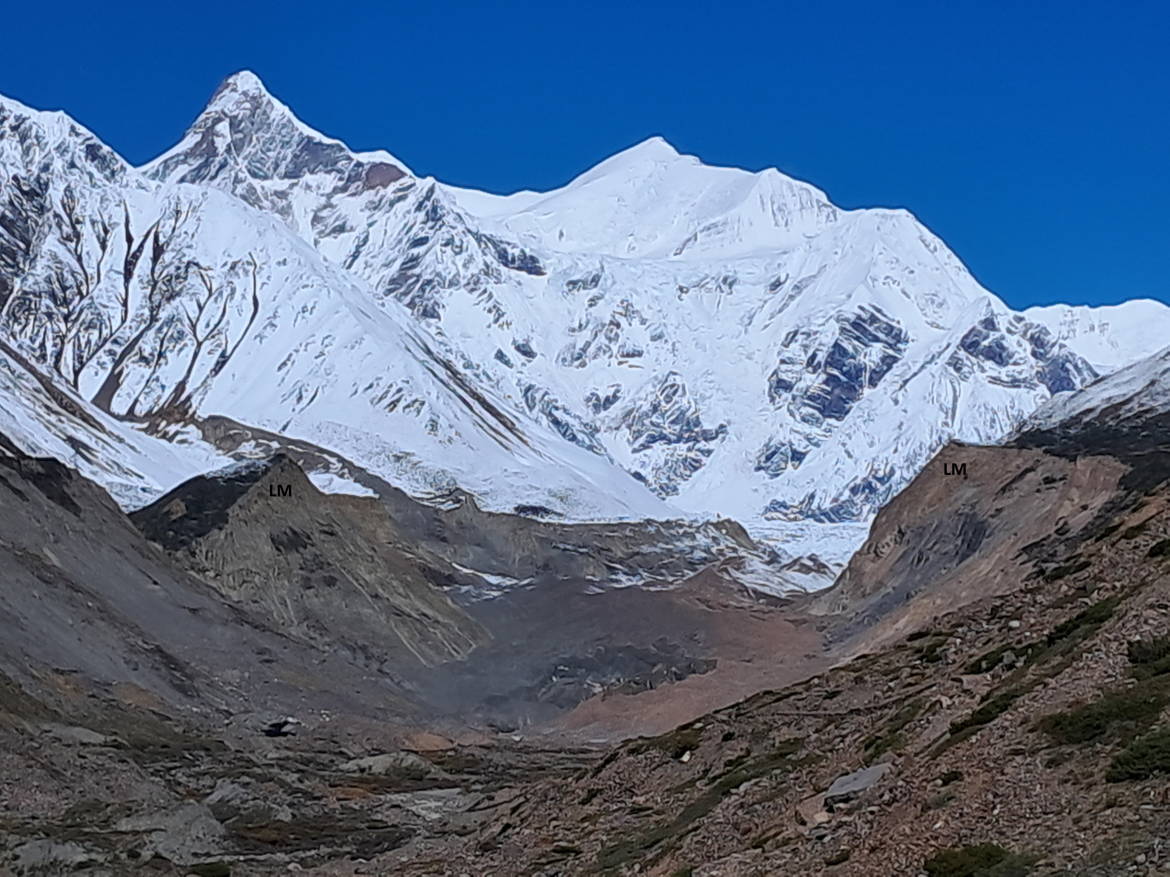
This photo of Milam Glacier shows two beautiful lateral moraines. Notice these have a sharp crest suggesting there are young in age (compare with the LM near Rilkot). They are thought to have formed as recently as the Little Ice Age just a few hundred years ago!  

This trail is a gift to geologists. I did a rather quick nine day walk through the main trail and noticed so much interesting geology. Along this path are vestiges of processes that occurred at different times and at different levels of the crust, from rocks that formed in a seething hot metamorphic cauldron that existed during the peak of Himalaya orogeny 20 million years ago, to glacial deposits from the historical Little Ice Age when children skated on the frozen  Thames River and much of the northern hemisphere experienced intense cold phases.  

A final nod to this fantastic journey. Spectacular leucogranite dikes and sills intruding gneiss on the stretch between Nahardevi and Laspa. 

There is much left to explore. I will be surely going there again.