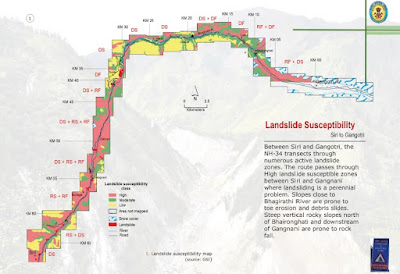
The Geological Survey of India has published a report of landslide susceptibility along the Char Dham routes being expanded in Gharwal, Uttarakhand. The Char Dham refers to the four holy sites of pilgrimage in the Uttarakhand Himalaya, namely, Gangotri, Yamunotri, Kedarnath, and Badrinath.
The report is available for download - Uttarakhand 2013 Deluge: Landslide Impact on Char Dham Routes
A series of maps of the routes are published showing landslide hazard zones.An example posted here is of the section between Siri and Gangotri
The report focuses on the damage done to the hill slopes due to the deluge and floods in June 2013 where intense runoff and river erosion caused massive landslides. But it also states that road building at places has resulted in the development of new landslide loci. That road building is triggering landslides along these routes is obvious judging by the regular reports of new landslides all across Gharwal. This is a well compiled report, but I despair that the advice of geologists and ecologists on the impact this road expansion is having on this part of the Himalaya is being ignored.
Instead, the GSI has this reassuring tip for travelers:
"This Coffee Table book will be of immense use for pilgrims passing through the landslide vulnerable tracts leading to the Char Dhams in Uttarakhand".
Happy Journey!


No comments:
Post a Comment