Friday, June 14, 2019

Insufficient Assessement: Pancheshwar Dam Uttarakhand

Environmental implications of Pancheshwar dam in Uttarakhand (Central Himalaya), India.

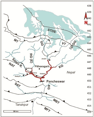
A warning from earth scientists that sufficiently detailed studies of seismic risks and potential environmental consequences have not been undertaken.

Map from the linked paper shows the location of the Pancheshwar Dam and the future backwaters in red.


Extract:

We have assessed the likely environmental consequences of the proposed Pancheshwar high dam in  Uttarakhand Himalaya (Indian Central Himalaya) in the light of current geologic and geomorphic   understanding. The study suggests that if executed in its current  format, the proposed  dam  raises  concern  about  safety  and  its sustainability due to seismicity, reservoir-induced  seismicity,  slope instability due to reservoir draw down effect, and unpredictable large volume sediment  mobilization from paraglacial zones. The study therefore, highlights the pressing need to re-assess the feasibility and its  geo-environmental implications through multidisciplinary studies.

During my recent travels in Kumaon I met locals who were also expressing fears over loss of livelihoods as large tracts of fertile land will be drowned. 

Open Access.

Friday, May 31, 2019

Geology Outreach: Darma Valley, Uttarakhand

A couple of weeks ago, in partnership with Deep Dive India,  I had taken a group of nature lovers from Bengaluru to the Himalaya for a geology outreach week. We traveled across a section of the Lesser Himalaya up to the town of Dharchula, and then headed north along the Kali valley and then the Dhauliganga valley to the area around the Panchachuli Glacier from where the river Dhauliganga (Darma river) emerges. The picture on the left shows our group at an outcrop of high grade metamorphic rocks. Picture credit: Asha Kini.

The participants were a mix of IT professionals, Chartered Accountants and Business Management executives. And they were an enthusiastic bunch. This was my first Himalaya outreach attempt and I was a bit nervous. But these people made my job much easier with their curiosity and active participation.

The map below shows our route in red.


Source: Geology, Structural and Exhumation History of the Higher Himalayan Crystallines in Kumaon Himalaya, India- R.C. Patel et. al. 2011

During our journey towards Dharchula and ahead, we drove across and learned about 'Klippen'. Beginning about 23 million years ago and continuing until around 15 million year ago, large faults (thrust faults) moved sheets of the high grade metamorphic Greater Himalaya and the oldest rocks of the Lesser Himalaya southwards, and placed them above lower grade metamorphic rocks of the Lesser Himalaya. Subsequently, erosion removed portions of these thrust sheets, leaving behind outliers or islands (Klippen) of these high grade rocks surrounded by the lower grade Lesser Himalayan rocks. We traveled across the Almora, Askot and Chiplakot klippen on our way to the start of our trekking point, which was north of Sobla. The map above shows the Chiplakot klippen surrounded by Lesser Himalayan rocks. 

Dharchula is situated on the low grade metamorphic rocks of the Lesser Himalaya Sequence. A little north of this town, we crossed into the Chiplakot Crystalline Belt (klippen), which is a  high grade metamorphic belt correlated with the  Munsiyari Formation (see map).  The Munsiyari Formation is considered the oldest unit of the Lesser Himalaya Sequence, made up of rocks metamorphosed to a higher grade. It contains the oldest rocks in the Himalaya, a very characteristic augen gneiss (named after the eye shaped clusters of quartz and feldspar), dated to 1.9 billion years.The Chiplakot Crystalline Belt and the Munsiyari Formation rocks both formed by extensive magmatism that was taking place along the Indian northern continental margin in the Paleoproterozoic (~1.9-1.8 billion years ago). These magmatic events were triggered by converging continental blocks, their eventual collision and suturing leading to the formation of a supercontinent known as 'Colombia'.

Just north of Sobla, we encountered the Greater Himalaya. The Main Central Thrust, known locally as the Vaikrita Thrust (VT), places these rocks on top of the Lesser Himalaya Sequence. We remained in this rock group for the rest of the trip. The Greater Himalaya in this area are made up of garnet to sillimanite grade gneiss, mica garnet schists, and migmatites, intruded by leucogranite sills and dikes. These leucogranites formed by the partial melting of buried Indian crust between 24 million and 16 million years ago. The picture, taken near Baaling village,  shows a leucogranite intruding gneiss. Arrows point to fragments of host rock entrapped in the intrusive magma.

Near Dugtu, we caught glimpses of the Tethyan Sedimentary Sequence high up on the ridges to the east and north of the village. And we found boulders of conglomerates and sandstones dislodged from these Tethyan rocks in small streams joining the Dhauliganga river. We also did a memorable walk along the banks of the Dhauliganga river right up to the point it emerges from an ice cave at the snout of the Panchachuli Glacier.

All along our route we stopped for geology observations at selected locations where lithologic breaks, rock folding, and fault zones could be seen. I gave the group small puzzles to solve, wherein they had to use their powers of observation and reasoning to come up with answers on the type of rocks, the sources of pebbles in streams, and differences between river and glacial deposits. In the evenings, informal discussions continued over piping hot delicious meals of roti, subzi, dal, and rajma.

I won't write in detail about the geology of this region, since I have covered it in an earlier post that I wrote when I visited this region two years ago. Please read that post titled 'Chasing the South Tibetan Detachment'.

I will make one addition to the geology covered in that post. Just north of Baaling village there is a sudden change in lithology. High grade gneiss, migmatites and leucogranites, formed at temperatures between 750-800 deg C, are overlain by lower grade metamorphic rocks (400-500 deg C) made up of slates, phyllites and greenschists (minerals like biotite, chlorite and actinolite). These lower grade rocks are locally named Budhi Schist. I could not see the contact between the two lithologic groups since the hillsides along the trail was covered with rubble and forest patches. The change seems to occur a few hundred meters north of Baaling.

I had earlier put this down to a continuous change in pressure temperature conditions within the Greater Himalaya Sequence. But walking across the lithologic transition one can notice the steep change in pressure temperature conditions as evidenced by the different mineral assemblages of the rocks, the absence of significant leucogranite in the lower grade rocks, the presence of dilation and en echelon fractures (evidence of stretching and tensile forces) in this zone, and the strong contrast in folding style between the two rock groups. Folding in the high grade rocks (upper pic) is manifest as ductile flow of dark and light colored mineral domains into wavy,  sigmoidal patterns, rootless isoclinal folds (light or dark colored mineral domains contorted into isolated folds) and ptygmatic folding of quartz-feldspar rich layers (the more competent quartz feldspar layers gets contorted into tight chaotic folds,while the softer surrounding layers flow around it) . In contrast, the strata in lower grade rocks show tight isoclinal and recumbent folding (outlined in  yellow) which can be traced over tens of meters. This indicates that the two rock groups were deformed at different depths under different rheologic conditions.

These abrupt changes in lithology and presence of extensional stress indicators strongly suggest that this transition is bracketed by a northerly dipping ductile shear zone (deeper crustal equivalent of a fault zone along which rocks are deformed and displaced) which separates lower grade hanging wall rocks (block above fault plane) formed in shallower levels of the crust from deeper crustal level and higher grade footwall rocks (block below fault plane). Lower grade hanging wall rocks juxtaposed against higher grade footwall rocks implies normal faulting.

Ideally, shear zones need to be recognized on structural criteria, i.e. the appearance of oriented structures in the rock fabric that indicate the sense of movement. Not having the required structural geology skills, I couldn't document accurately the shear sense (direction of displacement), but previous work carried out on this shear zone shows fabrics indicating a phase of top to the north-northeast normal shear, which means that the hanging wall rocks have been displaced downwards in a northerly direction. 

In the Central Himalaya two strands of the South Tibetan Detachment ( a network of extentional or normal faulting) have been recognized. The shear zone at Baaling likely represents the structurally lower strand of this fault system. The upper strand of this fault zone is present north of Dugtu village and brings into contact unmetamorphosed sediments of the Tethyan Sequence in the hanging wall with lower grade metamorphic rocks (Budhi Schist) in the footwall. 

I'll post below a few pictures of the landscapes around Naagling and Dantu villages. People of the Bhotiya tribes live in this region. We were at about 10,000 to 11,000 feet ASL. These villages  are abandoned for the winter as inhabitants move to lower altitude towns like Dharchula to spend the cold season. People start migrating back in the month of May. When we arrived, only a few families had made their way back. As a result, most villages had an empty feel around them.

1) High grade metamorphic massifs of the Greater Himalaya seen from Naagling.


2) Early morning sunshine hits Dantu Village.


3) Beautiful earthy homes and icy ranges in the background seen at Dantu.


4) Panchachuli Peaks seen from Dantu.


5) Village Goe basking in the sunshine.


6) Golden hues in the countryside around Philum village.


7) The Lassar Yankti valley (tributary of Dhauliganga) seen from Baun village looking north.


8) The picture postcard Baun village.


 9) Realm of the shepherds. Lush meadows with the Greater Himalaya looming all around. Near Baun.


10) Explaining the origin of the Himalaya to the Geo group. Picture credit: Samir Kher.


11) And.. that's me standing at the snout of the Panchachuli Glacier. You can see the river Dhauliganga emerging out of an ice cave. Picture credit: Prakash.


Overall, it was a great learning experience for me. And from the feedback I got, all the participants enjoyed it thoroughly too.

I will be doing this again!

Thursday, May 9, 2019

Links: Petroglyphs, Language, Urban Groundwater, Dams

Some interesting articles I came across past few days.

1) Pleistocene Rock Art in India- New York Times covers the discovery of ancient rock art (40k-10K yr old?) carved on laterite plateaus of Ratnagiri District, S. Maharashtra. Good to see credit given to the stellar work of two amateur archaeologists Sudhir Risbud and Dhananjay Marathe.

Link: Ancient Rock Art In The Plains Of India.

2) Language Evolution- Linguistic analysis suggests that the Sino-Tibetan language family originated about 7200 years ago among millet farming communities in northern China.

Links: Paper - Dated language phylogenies shed light on the ancestry of Sino-Tibetan.
Summary - Origin of Sino-Tibetan language family revealed by new research.

3) Urban Groundwater- This is an issue that is gaining importance as cities in India grow and municipal water supply from surface reservoirs becomes inadequate. S. Vishwanath crunches some numbers on the ground water potential of the shallow aquifer underneath Bengaluru. It comes to more than hundred billion liters! Similar situations exist underneath other Indian cities as well, but urban groundwater has been a neglected area of study. More quantitative understanding of aquifers is needed along with a focused effort to recharge ground water.

Link:  Revisiting The Shallow Aquifer

4) Environmental Implications of Pancheshwar Dam, Uttarakhand - A review in Current Science of environmental concerns regarding the proposed Pancheshwar Dam in Uttarakhand implies that critical aspects of seismicity, slope instability, and high sedimentation rates have not been addressed in detail during the planning stages in the environment impact assessments carried out so far.

Link: Environmental implications of Pancheshwar dam in Uttarakhand (Central Himalaya), India.

Tuesday, April 30, 2019

Eastern Ghats- The New Kid On The Block

We who live in the Deccan Volcanic Province in and near about the Western Ghats generally look down upon the Eastern Ghats. Call them the poor man's mountains. Point out that the Eastern ranges have a more gentle topographic profile than the Western ranges. We smirk at the lack of spectacular escarpments, narrow gorges and the mesas and pinnacles.

But, when it comes to geology, the Eastern Ghats more than holds its own. In fact, it has a much more complicated and interesting geologic history than the Western Ghats, at least the Deccan Volcanic part of the Western Ghats.

The Deccan Volcanic part of the Western Ghats is an elevated plateau which formed by the piling up of lava 66 million years ago and which since has been dissected by rivers, forming gorges, narrow valleys, and high relief. The edge of this plateau is the Western Ghat escarpment. The Eastern Ghats on the other hand is an ancient orogenic belt which formed by the collision between crustal blocks, resulting in the formation of fold mountains.

The map below shows the broad geology of the Eastern Ghat with the inset showing its location within the Indian continent.


Source: Relative Chronology in High-Grade Crystalline Terrain of the Eastern Ghats, India: New Insights: Samarendra Bhattacharya, Rajib Kar, Amit Kumar Saw, Prasanta Das 2011.

The Eastern Ghats is a Late Archean to Proterozoic age crustal block that has evolved through long and multiple episodes of magmatism, metamorphism and deformation.  It contains rocks ranging in age from 2. 9 billion years to 900 million years old. The rocks have some of the coolest names in petrology; charnockites and enderbites, khondalites, anorthosites and syenites along with granitic rocks and  sedimentary rocks like quartzites. Charnockites (and enderbites) and khondalites are granulite grade metamorphic rocks, i.e. they formed at very high temperatures of around 900-950 deg C by transformation of older igneous and sedimentary rocks respectively. Anorthosite is an igneous rock made up almost entirely of plagioclase feldspar. Syenite is also an igneous rock containing potassium and sodium rich feldspars with no or little quartz.

The interesting part is that the Eastern Ghat block was not part of India when these rocks formed. It may have been an independent block in the Archean (more than 2. 5 billion years ago), but at some point it became part of a larger block that is now the Antarctic continent. This region then underwent magmatism around 1.7-1.6 billion years ago, an episode of granulite metamorphism around 1.6 billion years ago in its southern regions, followed by sedimentary basin formation around 1.3 to 1.2 billion years ago. These sediments were then buried, intruded by magmas like syenites,  and subjected to another episode of granulite grade metamorphism around 1.2 to 1 billion years ago. This last episode of metamorphism and deformation was a result of continental movements and collisions related to the formation of the Rodinia Supercontinent.

When did the Eastern Ghats become part of India? Geologists have timed that event to around 500 million years ago, part of the assembly of Gondwanaland.

How did they figure that out? When the Eastern Ghat terrain collided with India in the Bastar region, it caused the Baster region crust to be buried to great depths resulting in the partial melting of that crust. Radiogenic dating of minerals titanite and zircon, which formed in these new melts, give an age of around 500 million years to this melting event.

I love it when these big ideas are depicted in simple and clean diagrams. Below is a graphic that shows the separation of the Eastern Ghat terrain from its conjugate Antarctica block called the Rayner Complex.


Source: Eastern Ghats Province (India)–Rayner Complex (Antarctica) accretion: Timing the event- Pritam Nasipuri, F. Corfu, and A. Bhattacharya 2018

Two scenarios are shown. The upper panel shows a composite Eastern Ghat Province-Rayner Complex colliding with the Greater Indian landmass around 500 million years ago, followed by a breaking away of the Rayner Complex. The lower panel shows that the Eastern Ghat Province had broken away from the Rayner Complex by 800 million years ago. It then collided with India around 500 million years ago.

The Indian continent was put together by the collision and welding of several smaller continental blocks, namely Dharwar, Aravalli, Bundelkhand, Bastar and Singbhum. This assembly took place between 2 billion and 1 billion years ago.

The Eastern Ghat block was the last to join India. As recent work suggests, as late as 500 million years ago.

Sunday, April 14, 2019

Human Evolution: Stories From SE Asia

Some recent finds from SE Asia are adding detail to the complex story of human migration and population interaction, and putting a much needed spotlight on the varied geographies and ecology in which human evolution took place.

1) Anthropologist John Hawks writes about the significance of the newly reported Homo luzonensis from the northern island of Luzon in the Philippines. This hominin appears to be small bodied like the 'Hobbit' (Homo floresiensis), which lived about 700 km to the south on the island of Flores. The fossils are at least 50,000 years old and their presence suggests that SE Asia was colonized several times by different hominin populations. How they were related to each other is currently an open and actively debated question.

Link: New species of hominin from Luzon.

2) Denisovans were an archaic group of hominins who diverged from the Neanderthals more than half a million years ago and lived over wide swaths of Eurasia and SE Asia. They interbred with more recent humans entering these regions, beginning about 60,000 years ago. Living Eurasians and Papuan people carry small amounts of Denisovan ancestry. A recent genetic analysis suggests that at an early stage in their history the Denisovans split in to two or three distinct groups, which then genetically diverged from each other. Papuans carry evidence of intermixing with these different Denisovan lineages.

Link: Multiple Deeply Divergent Denisovan Ancestries in Papuans (paper)
Summary: Ancient DNA reveals new branches of the Denisovan family tree.

3) Some of the oldest cave art has recently (2014) been found in Indonesia from the southern part of Sulewasi Island. They are estimated to be around 35,000 to 40,000 years old. A nice summary in Smithsonian Magazine details the discovery. Art forms of this antiquity from Indonesia suggests that a simple story of a singular origin of human symbolic thinking is not tenable anymore. 

Link: A Journey to the Oldest Cave Paintings in the World.