Thursday, March 17, 2011

Imagining The Atlantic Ocean

A passage from Simon Winchester's - Atlantic: A Vast Ocean Of A Million Stories

The Atlantic is in most places not at all like the Pacific or the Indian oceans - it is not dominated by the color blue, nor is it overwhelmingly fringed with leaning palm trees and coral reefs. It is a grey and heaving sea, not infrequently storm-bound, ponderous with swells, a sea that in the mind's eye is thick with trawlers lurching, bows up, then crashing down  through great white curtains of spume, tankers wallowing though the swells, its weather so often on the verge of gales, and all the while its waters moving with an air of settled purpose, simultaneously displaying incalculable power, and inspiring by this display perpetual admiration, respect, caution and fear. 

The Atlantic is the classic ocean of our imaginings, an industrial ocean of cold and iron and salt, a purposeful ocean of sea-lanes and docksides and fisheries, an ocean alive with squadrons of steadily moving ships above, with unimaginable volumes of mysterious marine abundance below. It is also an entity that seems to be somehow interminable. Year in and year out, night and day, warm and cold, century after century, the ocean is always there, an eternal presence in the collective minds of those who live beside it.

As with many of his other books there is a lot of geology in this one too, but it is evocative passages like these that I enjoy the most.

Tuesday, March 15, 2011

Academic Hierarchy In Germany

New York Times carried a story on the controversial resignation of German Defence Minister  Mr. Guttenburg on allegations that he plagiarized parts of his doctoral thesis.

On what a degree means in Germany:

Ms. Merkel, a former academic married to a professor, was being accused of belittling intellectual property theft and, by implication, the value of an advanced degree, which is not a purely academic matter in this country. Many jobs require such degrees in Germany, where, as is not the case in America, calling oneself doctor for having completed a thesis in, say, political science or art history, is not embarrassing but normal, even when filling out Lufthansa’s online booking forms. (The airline generously provides three levels of academic achievement for its overachieving countrymen: doctor, professor and professor doctor, skipping the extremely rare but not unheard-of German mouthful Herr Professor Doctor Doctor).

If I had to fill a Lufthansa online booking form I would be the lowest rung...just a .. Doctor.

Friday, March 11, 2011

Does The Indian Govt Prefer Google Over Bhuvan?

From a note in Geospatial World I learn that the Election Commission (EC) of India might be using Google satellite images as a background layer on which to placemark the locations of polling booths along with relevant information. The project will be initiated in the state of Bengal.

If this report of using Google is true, I am curious to know why the EC chose Google over Bhuvan which also serves out satellite images and is advertised by the Indian Space Research Organization (ISRO) to be customizable to incorporate the kind of functionality the EC wants.

Is it because - a) the EC was not aware of Bhuvan and its capabilities? In that case, ISRO has not done a good job of educating potential users about Bhuvan.

Or is it because - b) the Application Programming Interface i.e. the programming tools that allow developers to customize the application is not good enough?

Or is it because - c) Data policy restricts even government departments from accessing very high resolution imagery (1 meter) from Indian satellites for web applications, even internal ones like the proposed polling booth app. Government users may obtain without clearances high res images of a pre-defined extent i.e. images of one particular geographic area, but is a high res seamless image stream available to them through  Bhuvan?

Currently the data policy allows only imagery of resolution 5.8 meters and coarser to be released free of clearances in the public domain. Due to this policy Bhuvan can only stream images of 5.8 meters and coarser to the general public. The policy is supposed to be up for a review this year.

Whatever the reasons, it's a shame that Bhuvan and high resolution imagery captured by Indian satellites is being kept away from being utilized in innovative applications.

The government and ISRO need to introspect.

Saturday, March 5, 2011

Imaging Subsurface Structures In Hardrock Aquifers Could Help Small Farmers In India

I've written before  ( 1 2 3) on hydrogeologically complex aquifers of Deccan Basalts and other hard rock terrains in India and how they influence farmer livelihoods by controlling access to groundwater.

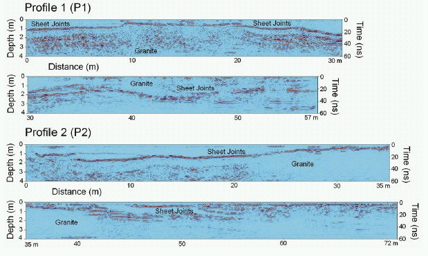
Mysaiah et al have published a paper (open access) in Current Science on the use of ground penetrating radar in imaging subsurface fracture systems (sheet joints) in granitic terrains around the city of Hyderabad.They suggest in their paper that this sort of information will be useful for modeling and understanding groundwater flow in shallow aquifers as well as a host of other engineering applications.

Here is an example of the imaged sheet joints:

Source: Mysaiah et al 2011

I wonder if this technique can be adapted  by state groundwater agencies to survey large tracts of land when mapping aquifer potential in other hard rock terrains like Deccan Basalts. This volcanic terrain too has a rock structure interrupted by horizontal sheet joints which control storage and flow of groundwater. The image below of a dug well shows ground water flowing out of the sheet joint in basalts.


Source: ACWADAM

State agencies when compiling working plans usually use the local watershed as the hydrologic unit when delineating aquifers. This in the end translates into a sort of generalized advice on groundwater potential and management to farmers. This is often of little use to especially small land owners who are farming plots less than a couple of acres or so. This scale of mapping will say nothing about what lies beneath such small plots.

Yet it is these small land owners who are in the most need of very specific advice on groundwater potential. In large regions of the Deccan Basalts and also in the granitic terrains of south India, monsoons and groundwater are the only source of water.

Farmers livelihoods depends on the aquifer properties. For making informed decisions on investing on drilling or digging for water, farmers would like to know whether fracture systems that could potentially yield water underlie their fields or whether they are sitting on top of a likely unyielding basalt or granite monolith. These are the types of investments which if they fail result in the farmer going down a path of indebtedness from which it is not easy for them to recover.

At a community level too there are movements now in India for farmers to form village level water sharing cooperatives and such surveys may lead to better ground water management practices.

Land based radar surveys of large areas may be cumbersome and expensive.. but it is an investment in technology and basic data generation that the government should give serious thought to - for it will result in a detailed and more site specific understanding of the shallow ground water system on which millions of farmers in India rely upon.