
All along India's coast there are indicators that 4000-6000 years ago sea level was higher than the present level, oscillating between 1-4 meters above present high tide level at different times. Since then, the sea has gradually receded to its present level. As a result, we can observe stranded beach ridges, cemented beach rock and dunes a few hundred meters inland of the present high tide mark. And we can see erosional notches on sea cliffs marking the past high tide level.
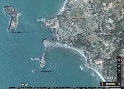
I saw these erosional notches in the sea cliffs exposed along the coast near Harnai village in Konkan.
The satellite image shows the location of the sea cliffs.
The picture below shows a sea cliff with an erosional notch (arrow) about 1.5 meters above the high tide level. This is at the Fattegad Fort near Harnai village. Also, notice the rocky platform that has formed at the current tidal level.

This notch can be traced all along the line of sea cliffs in the area. You can see it very clearly on this cliff, a little north of the previous location.

And the picture below shows a close up of the notch. Sea level must have held steady at this level for a few hundred years to have formed such a distinct erosional feature.

Why was sea level higher in the past? It has to do with the ice age and the end of the last glacial phase. The earth has been in the grips of an ice age for the past 2.6 million years. Conditions have cyclically fluctuated between colder glacial phases and warmer interglacial periods. During glacial phases, growth of polar ice caps results in a sea level fall. During warmer interglacial phases, polar ice caps melt and raise sea levels. The last glacial phase lasted between 115 - 12 thousand years ago. During this time the sea level was as much as 100 meters lower than today. Large swaths of the continental shelf was land then. The earth then moved into a warmer interglacial phase. As a result of melting polar ice, the sea has been rising steadily for the past 10-11 thousand years, flooding the continental shelf, and culminating in a sea level highstand (maximum) about 4000-6000 years ago. This maximum was about 1-4 meters above the present sea level.
There is evidence scattered all along India's west and east coast (and all over the world) of this Holocene sea level high. For example, there are tidal flat deposits about 1 meter above present sea level along the Porbundar coast in Gujarat. Shells collected from these deposits give an age of about 4000 thousand years. Exposed reefs from Mithapur in Jamnagar district in Gujarat give an age of about 2100 years. Oyster reefs exposed along Saurashtra coast about 2 meters above present sea level are about 2500-3000 years old.
To the south, in Madh Island (Mumbai) and along Konkan coast, there are layers of hardened sand and pebbles, locally known as 'Karal', which occur 2-4 meters above present sea level. These sediments once formed a pebbly beach. At Kelshi village in Konkan, there are fossil beach ridges a few hundred meters inland of the present high tide mark. I saw these on my recent visit. In central Kerala 4000 year old beach ridges occur 3 km inland, indicating that sea level was 3-4 meters higher then. Along the east coast, there are 4000-6000 year old beach ridges along the Krishna-Godavari coastline. These ridges become younger towards the coast, indicating that the sea has been receding since about 4 thousand years ago. Along the Baruva-Gandavaram coast in Andhra Pradesh, sea cliffs have preserved a succession of erosional notches at 4.7 m, 2.3 m and 1.8 m above sea level.
All these features indicate sea level peaked about 4000-6000 thousand years ago and has been falling in fits and starts since. The exact mechanism for this sea level fall is not well understood.
Scientists have put together data form various localities to come up with a composite sea level curve for the Holocene. The curve below has been drawn up using data from Gujarat and shows sea level rising throughout early and mid Holocene. The late Holocene has seen a lowering of seas.

Source: U.B Mathur et.al. 2004
This lowering has now been reversed and the seas are rising again globally, this time induced by anthropogenic global warming as continental glaciers melt and the ocean water expands as it gets warmer. It is estimated that sea level will rise between 0.5 - 1 meter by 2100. In centuries to come, the extent of sea level rise will depend on future warming trends and the extent of melting of the Greenland and Antarctica ice sheets. If significant portions of these ice sheets melt, sea level will rise by several meters in the next few hundred to couple of thousand years.
And what about the flat rocky platforms seen in the tidal zone below the sea cliffs? How do they form? The main mechanism is cliff retreat. Waves pound at cliffs cutting a notch at the bottom of the cliff. Undercutting of the cliff eventually causes collapse of the rock face and a retreat. Over time, as the cliff retreats, a broad sea facing platform develops. This is further acted upon by weathering. The likely process involves "water layer leveling" combined with wave erosion. Water layer leveling means the lowering and leveling of the rock surface due to physical and chemical weathering by the action of sea water. Standing pools of water and the continuous wetting and drying conditions in the intertidal zone act to weaken the rock and create a loose surface layer which is then removed by wave action, generating a flat surface.
The picture below shows a wide intertidal rocky platform from near Murud on India's west coast.

India's Konkan coast is beautiful and has interesting geology too. Do visit if you can.
References:
1) Falling Late Holocene Sea-Level Along The Indian Coast- U.B. Mathur, D.K. Pandey, Tej Bahadur 2004
2) Quaternary Sea Level Changes Along Indian Coast - S.S Mehr 1992
3) Evidence of Late Holocene shoreline progradation in the coast of Kerala, South India obtained from OSL dating of palaeo-beach ridges - Linto Alappat et.al. 2015
I saw these erosional notches in the sea cliffs exposed along the coast near Harnai village in Konkan.
The satellite image shows the location of the sea cliffs.

The picture below shows a sea cliff with an erosional notch (arrow) about 1.5 meters above the high tide level. This is at the Fattegad Fort near Harnai village. Also, notice the rocky platform that has formed at the current tidal level.

This notch can be traced all along the line of sea cliffs in the area. You can see it very clearly on this cliff, a little north of the previous location.

And the picture below shows a close up of the notch. Sea level must have held steady at this level for a few hundred years to have formed such a distinct erosional feature.

Why was sea level higher in the past? It has to do with the ice age and the end of the last glacial phase. The earth has been in the grips of an ice age for the past 2.6 million years. Conditions have cyclically fluctuated between colder glacial phases and warmer interglacial periods. During glacial phases, growth of polar ice caps results in a sea level fall. During warmer interglacial phases, polar ice caps melt and raise sea levels. The last glacial phase lasted between 115 - 12 thousand years ago. During this time the sea level was as much as 100 meters lower than today. Large swaths of the continental shelf was land then. The earth then moved into a warmer interglacial phase. As a result of melting polar ice, the sea has been rising steadily for the past 10-11 thousand years, flooding the continental shelf, and culminating in a sea level highstand (maximum) about 4000-6000 years ago. This maximum was about 1-4 meters above the present sea level.
There is evidence scattered all along India's west and east coast (and all over the world) of this Holocene sea level high. For example, there are tidal flat deposits about 1 meter above present sea level along the Porbundar coast in Gujarat. Shells collected from these deposits give an age of about 4000 thousand years. Exposed reefs from Mithapur in Jamnagar district in Gujarat give an age of about 2100 years. Oyster reefs exposed along Saurashtra coast about 2 meters above present sea level are about 2500-3000 years old.
To the south, in Madh Island (Mumbai) and along Konkan coast, there are layers of hardened sand and pebbles, locally known as 'Karal', which occur 2-4 meters above present sea level. These sediments once formed a pebbly beach. At Kelshi village in Konkan, there are fossil beach ridges a few hundred meters inland of the present high tide mark. I saw these on my recent visit. In central Kerala 4000 year old beach ridges occur 3 km inland, indicating that sea level was 3-4 meters higher then. Along the east coast, there are 4000-6000 year old beach ridges along the Krishna-Godavari coastline. These ridges become younger towards the coast, indicating that the sea has been receding since about 4 thousand years ago. Along the Baruva-Gandavaram coast in Andhra Pradesh, sea cliffs have preserved a succession of erosional notches at 4.7 m, 2.3 m and 1.8 m above sea level.
All these features indicate sea level peaked about 4000-6000 thousand years ago and has been falling in fits and starts since. The exact mechanism for this sea level fall is not well understood.
Scientists have put together data form various localities to come up with a composite sea level curve for the Holocene. The curve below has been drawn up using data from Gujarat and shows sea level rising throughout early and mid Holocene. The late Holocene has seen a lowering of seas.

Source: U.B Mathur et.al. 2004
This lowering has now been reversed and the seas are rising again globally, this time induced by anthropogenic global warming as continental glaciers melt and the ocean water expands as it gets warmer. It is estimated that sea level will rise between 0.5 - 1 meter by 2100. In centuries to come, the extent of sea level rise will depend on future warming trends and the extent of melting of the Greenland and Antarctica ice sheets. If significant portions of these ice sheets melt, sea level will rise by several meters in the next few hundred to couple of thousand years.
And what about the flat rocky platforms seen in the tidal zone below the sea cliffs? How do they form? The main mechanism is cliff retreat. Waves pound at cliffs cutting a notch at the bottom of the cliff. Undercutting of the cliff eventually causes collapse of the rock face and a retreat. Over time, as the cliff retreats, a broad sea facing platform develops. This is further acted upon by weathering. The likely process involves "water layer leveling" combined with wave erosion. Water layer leveling means the lowering and leveling of the rock surface due to physical and chemical weathering by the action of sea water. Standing pools of water and the continuous wetting and drying conditions in the intertidal zone act to weaken the rock and create a loose surface layer which is then removed by wave action, generating a flat surface.
The picture below shows a wide intertidal rocky platform from near Murud on India's west coast.

India's Konkan coast is beautiful and has interesting geology too. Do visit if you can.
References:
1) Falling Late Holocene Sea-Level Along The Indian Coast- U.B. Mathur, D.K. Pandey, Tej Bahadur 2004
2) Quaternary Sea Level Changes Along Indian Coast - S.S Mehr 1992
3) Evidence of Late Holocene shoreline progradation in the coast of Kerala, South India obtained from OSL dating of palaeo-beach ridges - Linto Alappat et.al. 2015
I remembered http://suvratk.blogspot.in/2010/02/tafoni-occurs-in-basalts-too.html?showComment=1265899707574#c4535978630046106749
ReplyDeleteyes! that was about the Korlai rocky intertidal platform. Good memory :)
Delete