Monday, December 27, 2021

Cyanobacteria And Mountain Building In The Paleoproterozoic

By 2.3 billion years ago, cyanobacteria employing oxygenic photosynthesis began proliferating in the world's oceans. This resulted, several hundreds of millions of years later, in triggering the formation of fold mountain belts in places where tectonic plates converge and collide. 

This big idea linking geological processes and biological evolution is explored in an interesting paper by John Parnell and Conner Brolly published in Communications Earth and Environment.  

Source: Examining the tectono-stratigraphic architecture, structural geometry, and kinematic evolution of the Himalayan fold-thrust belt, Kumaun, northwest India- S Mandal et.al. 2019.

Consider how fold mountain grow using this example from the Lesser Himalaya. The different colored layers are rocks formed on the northern margin of the Indian plate. They range from 1.8 billion years to around 50 million years in age. As the Indian continent collided with Asia around 50 million years ago, this pile of metamorphic and sedimentary rocks was squeezed by compressional forces. They were folded and broken up by thrust faults into a series of panels or sheets. Deformation of the Indian plate spread from north to south. As you gaze from the top to the bottom of the graphic you will notice that folding and faulting first began at the zone of collision (extreme right of the graphic). Over time the locus of deformation migrated further and further away from the site of continental contact. New faults grew and moved sheets of rocks southwards, stacking them and building mountains by thickening the crust.

Now look at the more detailed cross section below from Mandal's paper. The fold and thrust architecture of Lesser Himalaya is clearly revealed. The thin pink lines are the thrust faults and they have partitioned the rock pile into a series of panels (A-G), causing 'stratigraphic repetition' across the mountain belt. Internally, each panel has the same sequence of layers. I am ignoring some of the complexities of the formation of the Greater Himalaya for the sake of brevity.

Parnell and Brolly argue that the increased biomass in oceans starting 2.3 billion years ago produced organic rich sediment, which transformed on burial into carbonaceous shale and graphite bearing metamorphic rocks. The rates at which tectonic plates move meant that basins that filled up with such sediments began arriving at collisional zones some 200 million years since their initiation. 

Carbon rich and graphite bearing layers reduce friction along faults making the contractional deformation I outlined in the Himalaya example easier. The widespread mountain building activity observed in the geological record from 2 to 1. 8 billion years ago was helped along by faults preferentially splitting the rock pile along weaker graphite rich layers with the carbonaceous material acting as a lubricant, allowing easier movement and stacking of the faulted blocks. The nice graphic below compiles instances of mountain building that took place during that time frame from across the globe.  

Source: Increased biomass and carbon burial 2 billion years ago triggered mountain building- Parnell and Brolly 2021.

The authors give several examples of Paleoproterozoic orogenic belts in which major fault zones are associated with graphite rich layers. They also point out that the atomic arrangement of carbon in graphite that has been disturbed by faulting is different from the background graphite in sediment. Many fault zones in their examples contain this 'disordered' graphite bolstering their case that graphite was mobilized during fault movement.

This connection between carbon rich sediment and faulting appears as a recurring theme in geologic history. Another example comes from the Cretaceous when there was abundant deposition of organic rich sediment during times of globally high sea levels and oxygen depleted ocean depths. The resulting black shales subsequently provided the weak zones for faults to split and move crustal sheets during the building of the Rockies, the Andes and other mountain ranges spread widely across continents.

While it makes sense that carbonaceous material will reduce frictional resistance and enhance fault movement, one must be careful not to overemphasize the causal link between carbon rich sediment and mountain building. After building a case for the close association of carbonaceous sediments and major faults, the authors write, "Given the link between organic matter and deformation evident in younger rocks, the scene was set for collisional orogenesis at ~2 Ga (Fig. 1) by the exceptional accumulation of organic carbon during the mid-Palaeoproterozoic.

I would think that 'the scene was set for collisional orogenesis at ~2 Ga' not because of the presence of carbon rich sediment, but because by that time a global plate tectonic regime was operating and plate forces were maneuvering continents in directions that resulted in them converging at multiple places. The pulse of mountain building during that time period occurred because several continents crashed into each other. 

That the presence of carbonaceous sediment may aid faulting but is not a necessary condition for thrust fault regimes to develop in convergent settings is supported by looking at what occurred earlier in geologic history before the exceptional bloom in cyanobacterial growth and carbon burial. Yatin Zong and colleagues in a recent paper published in Nature Communications describe the formation of the Central Orogenic Belt of Northern China which formed by the collision of a chain of oceanic volcanoes with the North China continent in Neoarchean times (2.8-2.5 billion years ago). They demonstrate the development of fold and thrust structures and large distance movement along thrust faults that occurred in this convergent plate setting along the North China continental margin between 2.6 and 2.5 billion years ago. Here, thrust faulting detached sheets of the crust made up of lava erupted from oceanic volcanoes and also sediments deposited in adjacent basins and moved them hundreds of kilometers.  The fault surface was lubricated by copious amounts of the shiny mineral mica. 

This is several hundred million years before the exceptional accumulation of carbonaceous sediment in Paleoproterozoic times. It appears that the lithosphere deforms in a mechanically consistent style under the horizontal compressive forces prevalent in plate tectonic settings, with hydrated oceanic crust, water saturated clays, micas, and carbon being alternative candidates for reducing friction.

How did the outer shell of the earth behave before plate tectonics? Early earth was a much hotter place. Warm rocks are weak. Plate motion is driven by a pull force that is imparted as a tectonic plate subducts or sinks underneath another tectonic plate. So, for plate tectonics to evolve, the lithosphere or the outer shell of the earth has to become strong enough not to disintegrate as it is being pulled by its subducting leading edge. Such conditions, geologists think, likely became more and more common as the earth cooled sufficiently by about 3 billion years ago. 

Before this time tectonics played out as gravity driven vertical movements of the crust . This inference is based on the structures observed in many Archean age terrains which show large granitic bodies encircled by steeply tilted and metamorphosed volcanic and sedimentary rocks. On a hotter earth, buoyant granitic magmas rose and intruded the near-surface volcanic and sedimentary layers pushing them aside and thermally transforming them into low grade metamorphic rocks.

This ensemble of metamorphosed volcanic and sedimentary rocks are called greenstones. The typical structure is a granitic dome encircled by vertically oriented layers of greenstone having a flattened or schistose fabric formed due to the parallel orientation of platy minerals like micas and chlorite. The satellite image below shows one of the classic examples of this 'dome and keel' structure from the Archean age terrain of Pilbara from northwest Australia. Grey green narrow schist belts are wedged between light colored oblate shaped granitic domes.  The Pilbara terrain ranges in age from 3. 5 billion to 2. 9 billion years.

The Indian continental crust has its share of these Archean granite-greenstone associations. Some prominent ones are in Karnataka, exposed near Dharwar, Shimoga and Kolar. Most of these belts are older than 3 billion years in age.

Contrast this structural style with that of a classic fold belt from younger Proterozoic times. These are the famous Nallamala ranges in south India formed by horizontal compressive forces.

The earth changed considerably between 3 and 2 billion years ago. Chemical differentiation of magmas separated heavier elements from the lighter ones, forming continents made up of lighter buoyant granitic rocks and oceanic depressions floored by denser basalt lava. The growing mechanical strength of its outer shell formed coherent slabs or plates ultimately resulting in the more familiar plate tectonic cycles of super-continent formation and breakups. 

Another striking change appeared on the surface by 2 billion years; the formation of high topography. In the Archean, growth of new crust by constant injections of magma kept the outer shell warm and weak, unable to support the weight of tall mountains.  As the earth cooled the lithosphere gained strength and became rigid. High mountains built by tectonic thickening of the crust at continent collision zones could now stand on a strong foundation.

Folds, faults, crushed rocks, and mountain belts. All these dramatic contortions of the crust readily invite us to probe the physical evolution of the lithosphere as an explanation for the geological dynamism of our planet. Parnell and Brolly in their paper remind us that unique biological events have played a role too in shaping earth's physical features, even those as immense as the Himalaya.  

*******************

Wishing readers a very Happy and Safe New Year!

Friday, December 10, 2021

Links: Indian Monsoon, Hominin Footprints, Copper Mining

 Few links from past few weeks:

1) Rethinking the Indian Monsoons - This is a cracking good talk on the Sandip Roy Show with Dr. Sulochana Gadgil, meteorologist and an authority on the Indian monsoons. Dr. Gadgil talks about her career researching the monsoons. She elegantly explains the common misconceptions about its origins, pointing out the changes in monsoon patterns that have taken place over the past couple of decades, the difficulties in constructing accurate computer models and in predicting the future behavior of this complex phenomenon. She also draws an intriguing connection between variation in rainfall and crop yields. Drought years have lower yields, but there are no commensurate gains with excessive rain. There is also some advice on making Indian agriculture more resilient to climate change. All this interesting science is mixed with some delightful vignettes of her personal life too. Dr. Sulochana Gadgil is married to the well known ecologist Dr. Madhav Gadgil.  Exceptional interview! 

2) Multiple Bipedal Hominin Species 3.6  million years ago- A good write up of a reassessment of long forgotten set of footprints, from Laetoli, Tanzania. Scientists made new casts, developed digital reconstructions and compared them with a range of creatures. It looks like besides the famous Lucy (Australopithecus afarensis), another hominin species walking with a different gait coexisted in this area.

3) Copper Mining of the Future- Renewable energy infrastructure will require a lot of copper. Many times more than what we are mining now. Maybe, instead of blasting copper rich rock in giant open pit mines, we can suck out copper rich brines out of dormant volcanoes, like drilling for oil? Some speculation about this wild sounding idea. 

Thursday, November 25, 2021

Reverend William Buckland's Pie Crust


I came across this delightful passage in Elsa Panciroli's book, Beasts Before Us: The Untold Story of Mammal Origins and Evolution.

Naturalists exploring southern Scotland in the early nineteenth century came across some intriguing looking footprints impressed in red sandstone in a quarry at Corncockle Muir. The geologist Reverend Henry Duncan described these footprints and send some casts to the Reverend William Buckland who was making a name for himself in the emerging field of geology. The thinking was that these tracks were most likely made by crocodiles and turtles. Reverend Buckland came up with a clever way to test this idea. 

From Elsa Panciroli's book-

'Ist I made a crocodile walk over soft pye-crust [sic]' he wrote in a letter to Duncan, 'and took impressions of his feet...[second] I made tortoises, of three distinct species, travel over pye-crust, and wet sand and soft-clay...' Buckland's wife supplied the pie-crust and Buckland supplied the tortoises. Where the crocodiles came from is unclear, but as Buckland had a penchant for eating them he probably also had access to  live ones. The results : the marks matched the tortoises. He concluded, 'though I cannot identify them with any of the living species.... the form of the footsteps of a modern tortoise corresponds sufficiently well.... so I conceive your wild tortoises of the red sandstone age would move with more activity and speed... than my dull torpid prisoners.'

It was understood much later that these footprints in sand from Permian times (299 -252 million years ago) were made by early Therapsids from which arose the mammalian lineage. 

I am really enjoying this book! 

Monday, November 15, 2021

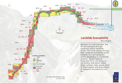
Char Dham Route Landslide Hazard Maps

The Geological Survey of India has published a report of landslide susceptibility along the Char Dham routes being expanded in Gharwal, Uttarakhand. The Char Dham refers to the four holy sites of pilgrimage in the Uttarakhand Himalaya, namely, Gangotri, Yamunotri, Kedarnath, and Badrinath.

The report is available for download - Uttarakhand 2013 Deluge: Landslide Impact on Char Dham Routes

A series of maps of the routes are published showing landslide hazard zones.An example posted here is of the section between Siri and Gangotri

The report focuses on the damage done to the hill slopes due to the deluge and floods in June 2013 where intense runoff and river erosion  caused massive landslides.  But it also states that road building at places has resulted in the development of new landslide loci. That road building is triggering landslides along these routes is obvious judging by the regular reports of new landslides all across Gharwal. This is a well compiled report, but I despair that the advice of geologists and ecologists on the impact this road expansion is having on this part of the Himalaya is being ignored. 

Instead, the GSI has this reassuring tip for travelers: 

"This Coffee Table book will be of immense use for pilgrims passing through the landslide vulnerable tracts leading to the Char Dhams in Uttarakhand".

 Happy Journey!
 

Sunday, October 31, 2021

Books: Volcanoes, Mammals, Himalayas

 New arrivals on my book shelf.

Fire and Ice: Volcanoes of the Solar System. Earth has them. So does the Moon and Mars. While eruptions on these three is molten silicate magma, there is plenty of variety in the rest of the Solar System. Io has sulphur rich emissions which drape the surface with a coating of  sulphur. Pluto has eruptions of nitrogen, methane, and ammonia that solidifies to form icy rock. Tidal forces unleased by Saturn on its moon Enceladus ruptures the moon's surface and triggers eruptions of fluids that fall back as snow and also contribute to the formation of Saturn's rings. Volcanologist Natalie Starkey delves into our current understanding of volcanoes of the Solar System and what we can learn from them about planetary evolution. Fascinating topic!


Beasts Before Us: The Untold Story of Mammal Evolution and Origins. Untold because most authors begin where the Dinosaurs end. The starting point is  usually at 66 million years ago, when a meteorite changed the world in an instant, reorganizing and vacating ecosystems into which mammalian lineages radiated. The story told by Elsa Panciroli goes way back, when Synapsids, the branch that led to mammals diverged from the common ancestor of mammals and reptiles. Repeat three times before going to sleep every night. Mammals did not evolve from Reptiles. These two groups shared a common ancestor in the Carboniferous about 300 million years ago. More and more fossils  are revealing that these early mammalian lineages were quite diverse, and not mere stunted underlings to the more popularly known Dinosaurs. For a lucid audio discussion of this book, listen to Elsa Panciroli on Paleocast Podcast- Beasts Before Us

 
 Himalaya: A Human History. My friend Emmanuel Theophilus is sure to like this one. I am thoroughly enjoying it. I didn't know much about ancient Tibet and Nepal, and what a rich history these two regions have! Ed Douglas tells these stories with panache and verve. And with a light touch. Lost empires,  ancient trade routes, master craftsman, art, architecture, spiritual masters, crafty power brokers, bloody military campaigns, missionaries, adventurers, botanists, colonialism, and recent geopolitics.  It really is an enthralling narrative of the epic history of this mighty mountainous region. I'll use the word 'remote' more carefully hence in my conversations about the Himalaya. This one is for you Theo!  

Monday, October 25, 2021

India Fossil Outcrops, Horse Domestication, Mars Landscapes

 From the past few days:

1) India is rapidly losing fossil rich outcrops to urbanization, expanding agriculture, mining, and unregulated fossil collection.

On International Fossil Day, October 23, 2021, the Paleontological Society of India, Pune Mumbai Student Chapter, organized a very informative online symposium on this topic. I have linked to part of the talks held that day. Paleontologist Dr. Rajani Panchang was the moderator. Several young researchers describe their field work in Kutch, Tamil Nadu, and Spiti Valley. Over the past several years, changes in land use and unchecked fossil removal has resulted in outcrop degradation and impoverishment.

.Video Permanent Link - India Fossil Outcrops .

Even though the Geological Survey of India and some local agencies have identified locations of geological importance, at present India does not have a law for the preservation of geoheritage sites. D.M. Banerjee writes about the struggle to get the Indian government to take up this issue seriously in his article Fate of Indian Geoheritage and Geopark Bill, published in the July 2021 issue of Current Science.

2) The origin of domestic horses has been a tough case to crack. It was long held using archeological evidence that horses were domesticated by the Botai Culture in Central Asia around 3500 B.C. But ancient DNA studies indicated that these early domesticated lines are not the ancestors of the modern domestic horse. Instead, the origin of the modern domestic horses have been tracked to the Volga-Don region in the Western Eurasian steppes between 2500 and 2000 B.C. The abstract of the paper is worth reading through- 

Domestication of horses fundamentally transformed long-range mobility and warfare. However, modern domesticated breeds do not descend from the earliest domestic horse lineage associated with archaeological evidence of bridling, milking and corralling at Botai, Central Asia around 3500 bc. Other longstanding candidate regions for horse domestication, such as Iberia and Anatolia, have also recently been challenged. Thus, the genetic, geographic and temporal origins of modern domestic horses have remained unknown. Here we pinpoint the Western Eurasian steppes, especially the lower Volga-Don region, as the homeland of modern domestic horses. Furthermore, we map the population changes accompanying domestication from 273 ancient horse genomes. This reveals that modern domestic horses ultimately replaced almost all other local populations as they expanded rapidly across Eurasia from about 2000 bc, synchronously with equestrian material culture, including Sintashta spoke-wheeled chariots. We find that equestrianism involved strong selection for critical locomotor and behavioural adaptations at the GSDMC and ZFPM1 genes. Our results reject the commonly held association between horseback riding and the massive expansion of Yamnaya steppe pastoralists into Europe around 3000 bc driving the spread of Indo-European languages. This contrasts with the scenario in Asia where Indo-Iranian languages, chariots and horses spread together, following the early second millennium bc Sintashta culture.

The paper is open access. And there is an easier to understand article in Nature as well. 

3) The remarkable range of technologies brought to bear on understanding the geology of Mars is giving some spectacular payoffs. Two studies caught my eye:

a) Mars' surface shaped by fast and furious floods from overflowing craters: Lake breach floods produced fast flowing streams that cut deep drainage valleys, reshaping the Mars landscape. Catastrophism has played a large role in the history of Martian surface evolution.

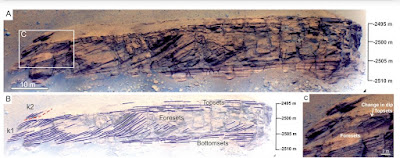
b) The Perseverance Rover rocks on!! The stunning images it has taken of rock outcrops on Mars is enabling geologists to reconstruct details of ancient sedimentary environments. N. Mangold and colleagues describe a delta lake system and flood deposits at Jezero Crater. 

Take a look at the details available to geologists for interpreting sedimentary processes and the rock history.

On Mars, large crater lakes were sites of sediment deposition. Rivers meeting such craters dumped their sediment on the crater floor in lobes that expanded lakewards forming a delta. The architecture of the sedimentary layers within this delta environment has been vividly captured and described in this study. In the image, the bottomset strata are fine grained sediment deposited in waters ahead of the delta. The foreset strata represent deposition on the inclined growing delta front. And the foreset strata are deposits of rivers associated with the delta. The paper is quite detailed and a treat for sedimentologists. But the images can be enjoyed by all. Open Access too!  

Saturday, October 9, 2021

Maps: India Contours

Once in a while I point readers to interesting and useful web mapping applications. Last week, Raj Bhagat Palanichamy, a specialist in GIS and Remote Sensing,  showcased a contour map on his Twitter feed. Intrigued, I found out that the contour map was from a web based application developed by Axis Maps. A detailed blog post explains how they developed the application and the elevation data sources they used to generate the contours. It is quite easy to use, with some controls to set contour intervals, line color, and to depict relief in color shades. 

I am putting a few examples from different Indian terrains to showcase this utility. It is not meant to be a critical review of the app (map scale is missing!), but a fun exploration of its capabilities, and the insights one can get about topography and other aspects of geomorphology and geology. Each example has a contour map on top and a satellite image of roughly the same area in the lower panel. All contours maps have been created using Contours- Axis Maps.

Western Ghats- Edge of the Deccan Plateau: Ghangad, Tail Baila Mesas

The edge of the Deccan Plateau has been deeply dissected to form some stunning relief. Steep sided ridges, mesas, and pinnacles poke upwards from more gently sloping and flattish surfaces. This step like appearance occurs due to the differing styles in which lava flows of varying hardness weather and erode away.  Towards the left-center of the contour map, where the brown meets the darker green, is what appears to be a sinuous thick brown line. It is really an amalgamation of contours, spaced closely, due to the extremely steep slopes and cliffs that make up the Western Ghat escarpment. There is a sudden fall there from the plateau to the coastal plain. Contour interval is 100 feet. 

Himalaya-Tibetan Plateau


Notice how the closely spaced contours in the lower left of the contour map give way to more openly spaced contours towards the top right of the map. This is the transition from the Gharwal Himalaya in to the Tibetan Plateau. The Himalaya, because it receives more rainfall, has more prominent relief, formed by rivers carving deep valleys, and glaciers gouging out rock faces into steep sided, sharp edged mountains. The Tibetan Plateau, although also standing high at around 4500 meters, is in the rain shadow region. It shows less relief. 

This has impacted the geology too. In the Himalaya, the rapid stripping of rock cover over millions of years has exhumed rocks which were once buried 25 kilometers below the surface. In Tibet, lesser erosion has meant that the surface geology is still dominated by 'supracrustal rocks', either volcanic or sedimentary rocks formed at shallow levels of the crust. Erosion has not dug deep down. Contour interval is 500 feet.

Nallamalai Fold Belt- Andhra Pradesh


This map shows the folded ridges of sedimentary rocks formed in the Cuddapah Basin around 1500-1600 million years ago. A fine example of topographic expression giving away the geologic structure of the rocks. Contour interval is 200 feet. 

I would urge those readers who are on Twitter to follow Raj Bhagat Palanichamy's excellent account (@rajbhagatt). He is a mapper par excellence.

Monday, October 4, 2021

Geology Crossword

A couple of years ago I reconnected with my Florida State University friend Shanker Venkateswaran.

Shanker is quite a geology and nature enthusiast. He has put together this geology crossword for beginners on the Crossword Club website.


Click on the link below for the full set of clues and the interactive version.

Geology Crossword - https://crossword-club.blogspot.com/2021/10/earth-science.html.


Saturday, September 25, 2021

LiveHistory India Videos: I Speak About Deccan Volcanism

LiveHistory India has started a wonderful outreach initiative, highlighting India's geological heritage. They invited me to talk about Deccan Volcanism. I spoke about how it all began, the physiography, places of interest, and the fossil bearing intertrappean sediments and their value in understanding ecology and broader patterns of extinction and recovery spanning the mass extinction that occured 66 million years ago. 

This was recorded a couple of weeks ago, and it is now online. The original recording was about 40 minutes, but it has been edited and the video is 17 minutes long. Subtitles are in Hindi.

Permanent Link- Deccan Volcanism And Its Various Aspects


LiveHistory has put out more such videos with other Indian geologists. 

1) India's Fossil Heritage- Dr. Sunil Bajpai

2) Markers of Earth's Formation in India- Dr. Pushpendra Ranawat

3) A Panel on Geological Heritage of India- Dr. Pushpendra Ranawat, Bidisha Bayan, Dr. Reddy, and Aliya Babi

Hope you enjoy my talk!

Tuesday, September 14, 2021

Links: Birth Of Species, Children's Book, Rise Of Oxygen

 Some geology and evolution material for your perusal.

1) I came across this well crafted documentary by Niles Eldredge and Stefano Dominici on the history of the development of ideas on the birth of species. It is a paleontologist's perspective with fossils being given the centre stage. A great many personalities who contributed to the early thinking on the origin of species are featured. Among the prominent ones who influenced Darwin were Lamarck, Cuvier, Giambattista Brocchi, and John Herschel to name a few. Completely left out of this film is Alfred Wallace. 

It does center around Darwin, and, later towards the end, on Niles Eldredge's work on Punctuated Equilibrium, which he published in collaboration with Stephen Jay Gould. I have often wondered whether there was any tension between Eldredge and Gould regarding proprietorship over Punctuated Equilibrium given Gould's very bombastic advocacy of this idea. The last section of this film is revealing! 

Beautifully compiled. Do watch. 


If  you are unable to access the embedded video, view it at this permanent link - The Birth of Species

2) Zircon (zirconium silicate) is a remarkable mineral. Born in the cauldron of magma chambers, it is henceforth virtually indestructible unless it is melted down again. This makes it a witness to geological processes affecting and shaping terrains over hundreds of millions of  years. What a story it has to tell us. And that is precisely what geochronologist Matthew Fox has done. He has written a children's book titled Jane's Geological Adventure, which follows Jane, the zircon grain, from her birth in a magma chamber to a life lasting 400 million years. Alka Tripathy-Lang reviews the book.

Meet Jane, the Zircon Grain—Geochronology’s New Mascot.

3) Elizabeth Pennisi writes about a new paper published in Nature Geosciences on the link between the increase in the length of the day and the rise of atmospheric oxygen on early earth. 

‘Totally new’ idea suggests longer days on early Earth set stage for complex life.

Wednesday, August 25, 2021

In Praise Of The Estuary

Be sure to take some time out and watch his lovely documentary on the Mulki Estuary by Dakshina Kannada Wildlife team.

Email subscribers who can't see the embedded video can watch it here - The Mulki Estuary.


This estuary has formed at the confluence of the Sambhavi and Nandini rivers (the documentary wrongly calls it the Gurpur river) on the Karnataka coast. Estuaries are particularly rich ecosystems. The confluence of fresh and saline waters, changes in water temperature and turbidity, nutrient supply by the river and coastal upwellings, the rise and fall of tides, and a meeting and interference of shore parallel and river currents create conditions suitable for a thriving biosphere. The documentary brings these aspects out beautifully in its capture of coastal landforms and varied wildlife.

Estuaries are of great interest to geologists too. The present configuration of our coastline has developed relatively recently in the geologic past. Before 15,000 years ago, during the Ice Age, sea levels were  about 100 meters lower than present. The coastline would have been tens of kilometers to the west of today's shore, and rivers like the Sambhavi and Nandini would have carved a valley across this stretch of the continental shelf and would have met the sea at a far westward location. As the Ice Age ended and the earth warmed, the rising seas progressively inundated the continental shelf. The estuaries along the Indian coast as with other coastlines are really drowned river valleys.

Coastal environments like beaches, mud flats, sand bars, mangroves, lagoons, and marshes, are in a state of constant adjustment to the movement of tides and currents, sediment supply from rivers and their distribution and deposition, and the impact of vegetation in stabilizing these features. Shore currents and sediment supply have an outsize effect on the evolution of the coast. One interesting example is found at Mangaluru, just south of Mulki, where another estuary has formed at the confluence of the Gurpur and Netravati rivers. The map shows this coastal setting. 

A geological investigation by B. R. Manjunatha and K. Balakrishna has shown that the Gurpur river once flowed a shorter route to the sea (paleo-course outlined in blue). Starting a few thousand years ago, excessive sediment deposition blocked this channel and strong southerly currents began building a barrier spit, forcing the Gurpur river to turn south and flow parallel to the coast for a good 8 kilometers before eventually joining the Netravati river in a joint exit to the sea. The Netravati river too has shifted slightly northwards over time. A quick survey along the Karnataka and Maharashtra coast show many similar situations where the river makes an abrupt turn and flows parallel to long sand spits before entering the sea. Do these rivers too have a similar history of course change? Its an intriguing observation.

Besides such adjustments to the coast due to currents and sediment deposition,  fluctuations in sea level too will change the prevailing geography. A sea level rise will push beaches and lagoons landwards, while a fall will cause rivers and deltas to extend seawards and bury past shorelines.

The estuary being a low lying region and a sediment trap preserves this history of sea level change. Geologists love to drill and take out sediment samples from the estuary bed and associated marshes and mangroves, because they contain, in its changing sediment and biological composition, clues to earlier environmental shifts. Understanding how past sea level change affected the coastal system is of great value in tuning our expectations and our preparedness of how the ongoing sea level rise will impact our present day coastlines.

I must confess that this post was inspired not just by this documentary but by my own memories of an estuary. During my student days, I had visited the coastal town of Malvan at the end of a small trek along the west coast of Maharashtra. A friend suggested we spend the day boating and exploring an estuary south of town. It turned out to be a most relaxing and enjoyable experience.

Taking inspiration from these children, we too rowed vigorously and covered quite a bit of distance. 

Malvan then was a small sleepy place and this meeting of river with the sea even more so. Not a soul was in sight, as hour after hour the waters of the estuary gently lapped against our boat. A salty sea breeze kept us refreshed. As the sun beat down upon us we finally decided to take a break. In search of something to eat and drink we scoured the shore for a small settlement. Up ahead in the middle of the estuary was our savior. 


 A luscious looking coconut island beckoned.

Monday, August 16, 2021

Readings: Mars Geology, Human Diversity, India Rock Art

 A few interesting readings:

1) NASA's Mars Perseverence Rover is hard at work. It has an amazing collection of geochemical instruments which are probing the surface with the aim of categorizing the mineralogy and chemistry of surface materials. The hope is to pinpoint regions which could have hosted microbial life.

Signs of Life on Mars: NASA's Perseverance Rover Begins the Hunt 

2) How are Andaman Islanders closer to Swedes than to Africans?

Razib Khan explain in this informative essay on patterns of human diversity and what it tells us about human migrations and population admixture over the past 100,000 years.

Out of Africa's midlife crisis-on bottlenecks, crashes and what diversity really looks like: How are Andaman Islanders closer to Swedes than to Africans?

3) On the Aravalli ranges quartzite rock faces in the state of Haryana is art created as long as 20,000 years ago. The locals always knew about it, but the Archeological Survey has just begun studying it in detail. 28 ancient sites have been found. I hope all of them get protection immediately. Smithsonian Magazine has a summary describing these finds. The final photo of rock art in the article depicts mounted warriors. Are they mounted on donkeys/mules or horses? Curious to know what readers think. I am leaning towards them being donkeys or mules.

These Millennia-Old Cave Paintings May Be Among India’s Oldest. 

Wednesday, August 11, 2021

Palaeontology Musings

It struck me a couple of days back that the field of paleontology and evolution has come up with some very evocative terms to describe phenomenon and name theories.

Take for instance the Red Queen Hypothesis. The term was coined by University of Chicago evolutionary biologist Leigh Van Valen in 1973. It is an explanation for his observations on patterns of extinction which came to be known as Van Valen's Law of Constant Extinction (itself a cool name). Van Valen did a broad survey of genus and family level extinction patterns of several different marine invertebrate groups and found out that the probability that a group could go extinct was independent of their age. The expectation might be that longer lived groups may have evolved more efficient adaptations and thus the likelihood that they could go extinct might decrease for older groups. 

Van Valen's finding was counterintuitive. A small clarification. The finding here is not that the rate of extinction is constant over time. It is not, obviously we just have to look at times of mass extinctions when rates of extinction increase enormously. What Van Valen found was that longer lived taxa were no better at avoiding extinction than newly appeared groups.

Why?...Enter the Red Queen. The inspiration for the name comes from Lewis Carroll's Through The Looking Glass. In it the Red Queen says to Alice; "Now, here, you see, it takes all the running you can do, to keep in the same place".

Van Valen reasoned that organisms are in a perpetual competition over resources. If one evolves a more efficient way of extracting resources, a cohabiting species will do so too. A sort of a metaphorical "arms race" results leaving both species at the same level of efficiency relative to each other. Besides, since evolution is changes in response to immediate challenges, already acquired adaptations cannot guarantee a fit to future environmental change. Longer existing taxa thus are likely to perish just as easily as newly emerged ones.

The Red Queen invited a lot of interest from evolutionary biologists and ecologists and has spawned rich directions of research since.

The other name I stumbled upon recently is Dead Clade Walking. This too concerns patterns of extinction and recovery. Paleontologist David Jablonski, also from the Chicago school of thought, in 2002, invented the term to describe his finding that many marine groups experience sudden drops in diversity spanning mass extinctions. Many don't go extinct but never quite recover fully either. It is not well understood why certain groups survive such global extinction events but then cannot rediversify. Some further work has shown that such drops in diversity without recovery need not be associated with mass extinctions but occur even during the background extinction that is going on. Understanding these patterns is another active area of research in paleontology. 

The type of research I've described readily invites a comment on how the field of paleontology has itself evolved. Besides the two scientists I mentioned, I will add David Raup, Jack Sepkoski, Elisabeth Vrba, Niles Eldridge and Stephen Jay Gould to name a few more. Beginning in the early 1970's these paleontologists collated large data sets of fossil groups, combing through literature and museum archives. They devised more expansive sampling strategies and subjected morphological measurements and life history attributes to rigorous statistical analysis. They used the emerging patterns to reconstruct broad histories of diversification and extinction and to test various evolutionary principles.  Their work reinvigorated paleontology from what was thought of as a descriptive field to one that began making significant contributions to evolutionary theory. This big picture approach inspired biologist John Maynard Smith to acknowledge that paleontology is ready to join the "high table of evolutionary theory". 

Do you know of a cool name for an earth science phenomenon or theory? Drop in a comment.


Wednesday, July 28, 2021

Darwin: Caught Between Catastrophism And Gradualism

This past Saturday was Guru Purnima and I thought I would share a short post on two of Charles Darwin's mentors who had a big influence on him particularly in the early days of his scientific career. Adam Sedgwick and Charles Lyell were both geologists whom Darwin looked to for advice and inspiration. Although Darwin had a rather broad training in natural history, he initially considered himself a geologist. 

Just before embarking on his voyage aboard the H.M.S.Beagle in 1831, Darwin had spent some time doing fieldwork in Wales with Sedgwick. Over a couple of weeks Darwin became proficient in identifying rock types, describing outcrops, and mapping and interpreting the regional geology. He first met Charles Lyell after he returned from his voyage in 1836, although he had been regularly corresponding with Lyell about geology. 

Adrian Desmond and James Moore's biography Darwin: The Life of a Tormented Evolutionist has a lovely description of Darwin's early encounters with geology as he began his travels aboard the Beagle with the shadow of Sedgwick and Lyell following him around. 

The Beagle has reached St. Jago in the Cape Verde Islands, about 300 miles off the African coast. There Darwin saw a fossil bed, rich in shells and corals, about 30 feet above sea-level. 

An extract from Desmond and Moore's book: 

" Sedgwick in North Wales had inducted him into Cambridge-style geology- a science of violent crustal movements,wrenching strata, and mountain thrusts. But how had this seashell band arrived at this height above the ocean? Lyell's Principle's of Geology could help here, even though Henslow had said to beware. Lyell pictured a world constantly and slowly changing, with the past no more violent than the present - so that today's climates,volcanic activity, and earth movements balance one another, land rises in one area as it falls in another, not cataclysmically, as Sedgwick thought, but gradually".

 Darwin studied the fossil band and reasoned that the sea itself could not have fallen over the lifetime of St Jago islands (he was wrong in this assumption, but at that time the causal link between short term climate change and sea-level fluctuations was just not appreciated). The fossil layer did not exhibit any signs of a violent geological change. He decided a gradual uplift of the volcanic island was a better explanation for the stranded fossil bed.

Darwin became and remained a gradualist throughout his lifetime. Gradualism was one of the central ideas of his theory of evolution. That biological change too proceeds slowly was something he had imbibed from Lyell's thinking about geological processes. 

His geological observations about South America were well received by his two heroes. Lyell introduced him to Britain's science elite and Darwin quickly received invitations to join various Geological Societies. He was ready to embark on a serious geology career, but a nagging question about the nature of life eventually took him on a different path. 

His work on transmutation began consuming him as he wholeheartedly devoted his research energies to solve the 'mystery of all mysteries'; how do new species originate and change?  Even after he drifted away from any serious geological work, Darwin remained a close friend with both his mentors. But neither ever embraced his theories of evolution. Sedgwick and Lyell, rooted in Anglican tradition, could not shake of their religious convictions and accept a naturalist explanation for life that Darwin had proposed. 

 Sedgwick was particularly severe in his criticism. He wrote on reading The Origin of Species (quoted from Desmond and Moore's book):

.." Parts of it I admired greatly, parts I laughed at till my sides were almost sore, other parts I read with absolute sorrow because I think them utterly false and grievously mischievous. You have deserted... the true method of induction,and started in machinery as wild, I think, as Bishop Wilkins's locomotive that was to sail with us to the moon".

Sedgwick and Lyell's cold shouldering of his theory caused Darwin immense pain. He had always felt at home with the geology community of Britain whom he thought of as more of a gentlemanly fraternity than the cantankerous zoologists. Desmond and Moore describe how physically sick  Darwin felt after a futile conversation with Lyell about his ideas on transmutation. Shivers, shakes, fever, vomiting became routine maladies throughout his later life, manifestations of the inner turmoil of working on an extremely unpopular theory.  But the dogged and outstanding scientist that he was,  he could not and did not let his mentor's rejection persuade him to stop his work or change his thinking. Patiently and 'gradually'  he put the pieces together and built a body of work that changed the world forever. 

***********************************

On a personal note, a warm welcome to new email subscribers who signed up after I switched to MailChimp. Do press reply and drop in a line to say hello. Thank you again for your interest.

Thursday, July 15, 2021

Fire Initiated The Anthropocene

James C. Scott in his book Against The Grain: A Deep History of the Earliest States makes the case for the transformational impact of fire on our environment.

" Hominids' use of fire is historically deep and pervasive. Evidence for human fires is at least 400,000 years old, long before our species appeared on the scene. Thanks to hominids, much of the world's flora and fauna consist of fire adapted species (pyrophytes) that have been encourage by burning. The effects of anthropogenic fire are so massive that they might be judged, in an evenhanded account of the human impact on the natural world, to overwhelm crop and livestock domestication. Why human fire as landscape architect doesn't register as it ought to in our historical accounts is perhaps that its effects were spread over hundreds of millennia and were accomplished by "precivilized" peoples also known as "savages". In our age of dynamite and bulldozers, it was a very slow-motion sort of environmental landscaping. But is aggregate effects were momentous."

The impact of human activity on the earth's outer skin has been so considerable that atmospheric chemist Paul Crutzen proposed that we are now living in a new geologic epoch, which he called the Anthropocene. This has sparked a vigorous debate on whether a new division of our time scale is justified, and if it is, on where to place its beginning. James C. Scott make a distinction between what he terms the "thick" Anthropocene, contrasting with the idea of a  "thin" Anthropocene. 

A "thick" Anthropocene is manifest by a sudden appearance of a worldwide signal of human activity. Examples of this could be the advent of the Industrial Revolution, or even more catastrophically, the nuclear age in the 1940's which left global radioactive markers.  The "thick" Anthropocene appears to fit more closely geologic convention which demands that the beginning of a new geologic time unit need be recorded by a widespread and more or less synchronous preservation of biological and chemical changes. 

Scott calls fire, agriculture, and domestication as part of the complex that comprises a "thin" Anthropocene. These inventions changed the world patchily and slowly. Its signals appear here and there, not encoded in one geologic layer, but in many, smeared over the past few hundred thousand years. 

The term "more or less synchronous" I used to describe a new geologic boundary is relative to where in the geologic past the observer is. More recent changes are resolvable to a finer degree either as a matter of historical record or by methods like counting tree rings and annual/decadal growth layers in stalactites, cross calibrated by either carbon dating or some other radiometric dating method. The error bar increases as one goes further back in time. Take the great mass extinctions of the past. There will be a sediment layer to which a geologist can point to and state that this marks the boundary between say the Ordovician and the Silurian or the Permian and the Triassic. But that sediment layer certainly wasn't deposited instantaneously. It likely represents a few thousand years of elapsed time. If you were an observer who spent a few years in the Late Ordovician 443.8 million years ago, the situation would have been more akin to Scott's "thin" Anthropocene, with small changes occurring at different times in different places. You would have been unlikely to have anticipated the profound cumulative shift that would eventually accumulate.

Most mass extinctions which form the basis of the big divisions of geologic time unfolded over thousands of years, but their material record is collapsed into a few feet of sediment. We perceive these geologic turnovers as 'sudden' because the preceding and succeeding periods of relative stability lasted tens of  millions of years and the time the 'boundary layer' spans is unresolvable using our current dating methods.

The exception to this is that fateful day 66.03 million years ago, when a large meteorite struck what is now the Yucatan Peninsula. By the time the dust had settled (literally) in a few weeks, the world had irrevocably changed. The Cretaceous-Paleogene boundary layer is in an absolute time sense a truly instantaneous deposit. We interpret it as instantaneous, not by radiometric dating, but by using our understanding of the physical sedimentation processes that would have been triggered by the impact.

The lesson we can draw from the transformational events from deep geological time is not about the debates over the timing of Anthropocene but on its effect. Like those distant ecologic disruptions, we too have set off biological, chemical and physical processes on a different trajectory than they were several thousands of years ago. The Anthropocene will leave a permanent mark on the many future worlds to come.

Tuesday, July 6, 2021

Coccolithophore Life Cycles and Calcite Morphology

Our world is full of examples of biological processes leading to exquisite geological products. And none more so than the one observed in the Coccolithophores. These are single celled marine algae. They produce crystals of calcite (CaCO3), which they use to create a shell around their tissue. The shell is called a coccolith. The amount of calcium carbonate used up in these shells is enormous. About 10% of global carbon is fixed in coccolithophores, making them an important carbon sink. 

The shapes of these calcite crystals vary enormously according to species, but also, as I found out in a recently published paper, on life cycle stages of the organism.

Coccolithophores have haploid (one set of chromosomes) and diploid (two sets of chromosomes) life cycles. In a haploid life cycle stage relatively simple rhombic crystals are produced in a vesicle inside the cell. The entire shell (holococcolith) is made up of an aggregation of such rhombic crystals. The diploid life cycle stage produces more complex mineral forms. Here too, the crystals are produced inside a vesicle or a compartment inside the cell, but scientists find that the development of shape may be mediated by silicon. The resulting shell (heterococcolith) is intricately shaped, made  up of a variety of crystal shapes in different species. The functional role of the shells could be varied. They may be providing mechanical stability, helping in maintenance of buoyancy, or in scattering harmful ultraviolet light in the upper column of the ocean.

Take a look at this magnified pictures of holococcoliths (a and c) and heterococcoliths (b and d). Scale bar: a and b = 5 micrometer. c = 500 nanometers. d = 1 micrometer.

Source: Role of silicon in the development of complex crystal shapes in coccolithophores: Gerald Langer et. al. 2021.

The prevailing thinking has been that the holococcoliths and heterococcoliths represent two independent origins of calcification. However, this study finds  that the calcite production sites in both life cycle stages are intracellular, and they likely use the same cellular mechanisms to transport ions, maintain calcium carbonate saturation levels, and to modulate the shape of the growing crystal by suppressing and enhancing specific growth directions. 

Based of this similarity in basic processes the researchers propose that the last common ancestor of this algal group must have had the ability to produce both holo and heterococcoliths. Holococcoliths being simpler represent the ancestral form of biomineralization in these algae. Initially, both haploid and diploid life cycle stages would have produced only holococcoliths. The haploid life stage retained this form of calcification. Subsequently, the diploid phase gained additional functionality to produce more complex crystals. Heterococcoliths thus evolved later in this ancestor,  recruiting silicon to mediate, in not yet fully understood ways, the production of varied crystal shapes. 

These algae acquired the ability to calcify around 250 million years ago. Interestingly, the simpler holococcoliths appear in the fossil record a good 37 million years later than the heterococcoliths. Scientist think that this could be an artifact of poor preservation of the simpler more fragile holococcoliths.

A parallel development in the marine realm has also had an impact on coccolithophores and other biomineralizing species. Another group of algae known as the diatoms started proliferating in the oceans in mid late Mesozoic by around 200-150 million years ago. Diatoms use silicon to produce beautiful skeletons. They progressively became efficient removers of silica from sea water. In the mid Mesozoic, large reefs built by the silica secreting sponges were common in the shallow marine settings. By late Mesozoic -Early Cenozoic times silica sponge communities shifted to deeper water and to higher latitudes, an ecologic displacement, some scientists think, forced by silica limitation in shallow tropical waters.  

By Cenozoic period diatoms had become the dominant silicon extractors from the upper layers of the ocean. So much so, that this diversion of silicon by diatoms impacted  Coccolithophores too. Many species stopped using silicon to mediate crystal growth, instead evolving alternate pathways to build their calcium carbonate shells. 

I love stories of the intricate interplay and feedbacks between evolution and geology. This is a theme I keep returning to. 


Friday, July 2, 2021

Dear Email Subscribers

Dear Email Subscribers-

Starting with this post, emails to you will be delivered courtesy MailChimp. Feedburner which has been sending you updates to my blog all these years is discontinuing its email subscription service from July. Your email addresses have already been transferred to MailChimp, so there is no need for any action on your part. 

I did get some feedback while I was testing out this new service. For some Gmail addresses, post were being directed to the Promotions folder. Please do keep an eye out for Rapid Uplift mails in your Promotions folder too and manually move them to your inbox so Gmail learns to treat them as Not Spam. I am still tinkering with the style aspects so you can expect subsequent emails to have differing formatting. The content however will remain strictly geology! :)

Over the years, I've had the privilege of being followed by a substantial subscriber base. Naturally I don't know most of  you personally. Feel free to press the Reply button and drop a line. I would love to hear from  you. 

Thank you again for your support and motivation.

Suvrat Kher

Friday, June 25, 2021

Articles: Trace Fossils, Supercontinents, Harappan Hydrology

 Some interesting geology rich readings from the past few weeks:

1) Ichnology is a branch of palaeontology that studies the traces made by organisms in soft sediment. These could be tracks and trails as animals move around on a substrate, or burrows constructed as escape structures or as dwellings, or bite marks on shells and bones. All these are indicative of behavior, which otherwise would be hard to discern from just the fossilized remains of body parts. Science writer Jeanne Timmons has written this lovely article on Ichnofossils and what they tell us about past ecology and animal behavior.

Trace fossils, the most inconspicuous bite-sized window into ancient worlds.

2) The earth has seen over its long geological history episodes of continents coming together to form a supercontinent, then breaking up and drifting apart forwhat seems an eternity, but eventually coalescing to form another giant landmass. When did this supercontinent cycle begin on earth. What are the forces that initiated and subsequently has maintained this mode of surface reconfiguration, and what are its consequences on tectonics, and the physical and chemical evolution of earth. A great review article by Ross N. Mitchell and colleagues.

The Supercontinent Cycle.

3) The rivers that sustained the Bronze Age Harappan Civilization have been the subject of lively research in recent years. Ajit Singh and colleagues have worked on the Markanda river catchment in the Sub-Himalaya dun region. Markanda joins the Ghaggar-Hakra river flowing through present day Harayana, Punjab and Rajasthan. They find that during the Mature Harappan Period (2600 B.C. to 1900 B.C.), large floods in the Himalaya foothill rivers sustained flow in downstream reaches, making  agricultural viable, even as northwestern parts of India experienced a reduction in summer monsoon strength.

Larger floods of Himalayan foothill rivers sustained flows in the Ghaggar–Hakra channel during Harappan age (behind paywall).


Tuesday, June 15, 2021

Lessons From A Hot Past

This short editorial published recently in Nature Geoscience is worth reading and thinking about. It summarizes our findings of past climate change and how earth systems such as sea level, glaciers, and the biosphere responded to these climate swings. 

Reconstructing temperatures going back to the Eocene (~50 million years ago) and later in the Miocene (~ 15 million years ago) reveal a very different world. These finding do come with a caveat. The rates of change are averaged over thousands of years, while we today stare at an unfolding catastrophe in our lifetimes. 

There is data though from more recent times that can tell us in finer temporal detail how climates fluctuated. Carbon dioxide trapped in Antarctica ice sheets points to changing atmospheric composition on a centennial scale and tree ring data informs us about seasonal changes in rainfall.

The current level of CO2 in the atmosphere of about 415 ppm (parts per million) are the highest since the Pliocene, more than 3 million year ago. We are also pumping CO2 at rates which are unprecedented in geologic memory, a shift from about 280 ppm to our present levels in just about 150 years The past may not provide a perfect analogue for the rapid changes we are experiencing, but it does send us a sobering warning that civilization's envelopes of comfort will be breached not so far in the future.

Nature Geoscience Editorial: Lessons From A Hot Past.

Monday, June 7, 2021

Liesegang Banding In Proterozoic Badami Sandstone

The Chalukya era (6th-8th CE) rock cut caves and sculptures at Badami in Karnataka are an archeological wonder. But there is plenty of geology there to admire. In January 2020, I spent some time wandering through Badami. The sandstone layers are 900 million years old river deposits. I wrote a long post about them, explaining the primary sedimentary structures that one can observe in these rocks, and what they tell us about the water depths and currents during deposition of the sediment. 

But these primary structures, i.e. sedimentary layer orientations that form during deposition, are not the only interesting features of these rocks. Chemical reactions in these sediments after their burial has overprinted an intriguing fabric on to the rock.

In the picture a very distinct dark and light banding is seen in one of the Badami rock surfaces. This is Liesegang banding. 

The dark bands are rich in iron oxide. The lighter bands have little or no iron oxide. Such banding forms by the mobilization of ions from one location in the sediment and their precipitation at another. Ions diffuse along a concentration gradient in the water filled pore spaces. Robert A. Berner's book, Early Diagenesis: A Theoretical Approach, has a good explanation for the formation of Liesegang banding. I am reproducing that below.

"Mobilization of different components of a substance can occur at two or more different locations. The best example of this is the formation of Liesegang banding.In Liesegang banding we have the interdiffusion of two dissolved ions which cab react with one another to form a relatively insoluble solid. The two ions can come from different sources and when their concentrations at a given site build  up, via diffusion, to sufficiently high values, precipitation of the insoluble solid occurs. This precipitation suddenly lowers concentration in the neighborhood of the solid, and as a result the diffusion profiles become altered. Continued interdiffusion results in a new build-up in concentration and precipitation at another site. Depending on the geometry of the situation, this process may result in Liesegang rings (3-dimensional), tubes (2-dimensional), or layers (1-dimensional). A common example of Liesegang phenomenoa are rhythmic bands of iron oxides often found in sandstones. In this case precipitation is most likely brought about by the interdiffusion of dissolved Fe++ (from an anoxic) source) and dissolved O2 (from an oxic source). Where the Fe++ and O2 meet, Liesegang banding occurs".

The iron (Fe++) would already have been present in the sediment perhaps in discrete grains of pyrite (FeS2), or trapped in carbonaceous plant debris.   Rainfall fed groundwater is the common source of oxygen.  As pyrite gets oxidized it releases Fe++ and sulphur ions. The ferrous ions get oxidized to ferric ions (Fe+++). These then nucleate to form iron oxide or hydroxides. Rapid diffusion of ions towards a growing crystal will eventually lower the concentration of ferric ions in the region surrounding the grain to below the nucleation threshold, at which point crystal growth stops. This threshold is reached at a different location where pyrite oxidation is releasing a fresh supply of Fe++. At this new location the concentration of ferric ions build up again to levels where they start nucleating into iron oxide. This migration of zones of dissolution (of pyrite) , diffusion, and nucleation results in the distinct banding. I've summarized this explanation from a paper by P. Ortoleva and colleagues on redox (reduction-oxidation) front propagation and formation of mineral banding.

Formation of redox fronts during the burial of a sedimentary rock can be economically important. For example, a certain type of sandstone hosted uranium deposit known as 'roll-front' occur where oxidizing fluids containing dissolved uranium meet reduced components such as pyrite or organic matter. 

Here is another close up of these Liesegang bands. They have a ring or a tube like geometry. The cross bedding indicated by the arrow is a primary structure formed by the movement of sand sculpted into ripples or waves on the river bed. The Liesegang bands have been imprinted over the cross beds subsequently. 

The chemical reactions that occur in sediment after their deposition are of great interest to geologists.  They play a large role in the reorganization of porosity and permeability through the dissolution and re-precipitation of minerals.Throughout the history of a sedimentary basin, fluids move through these pore networks mobilizing elements, and under favorable conditions, enriching them at particular locations. Geologists prospecting for metal and hydrocarbon deposits want to understand this process.


Thursday, June 3, 2021

Permian Seafloor Gardens Of Glass


In Metazoa:Animal Minds and the Birth of Consciousness, author Peter Godfrey-Smith describes the Hexactinellida, a group of sponges that construct hard parts made of silicon dioxide as a support for its soft tissue. In an earlier post I had written briefly about amorphous varieties of silica. The Hexactinellidae's skeleton is made up of opal, denoted by the chemical formula SiO2.nH2O. Sponges put together their skeleton using a variety termed opal-A , the A indicating amorphous. Over geologic time the amorphous opal-A often transforms by expelling water and re configuring the geometry arrangement of silicon and oxygen atoms to opal-CT and chalcedony, both silicon dioxide varieties showing the first glimmer of a crystalline structure.

Hexactinellida are popularly called the glass sponges because of their transparent silica frame. The basic elements of this skeleton are tiny rods or spicules which are joined to form dagger, star or snowflake like shapes. These then group together to form a hard mesh that supports the soft tissue. Upon death, the silica skeleton disintegrates, leaving a carpet of spicules on the sea floor. 

The sketches below are from Godfrey-Smith's book. They are drawings by Rebecca Gelernter of  sponges collected on the Challenger expedition of the 1870's.

One fascinating function of these glass elements could be as collectors of light. Sponges often have colonies of photosynthetic organisms like diatoms living inside them. The speculation is that the glass channels light energy into the interior of the sponge body, which the diatoms use as a power source for photosynthesis.

Glass gardens on the sea floor is an evocative way to describe these sponge communities. And occasionally in geologic history these gardens have proliferated on a scale that is simply hard to imagine. Some time back I read a very interesting paper by Edward J. Matheson and Tracy D. Frank on Late Permian age (~260 million years old) sedimentary rocks deposited on the northwestern shores of the supercontinent Pangea. Different sedimentary rock types were deposited in this long lived basin. One distinct layer, termed the Tosi Chert, contains significant amounts of chalcedony and chert. A closer examination revealed that these two silicon dioxide minerals were derived from a siliceous sponge precursor.

Scattered through these Permian rocks are 'ghosts' of spicules. The Tosi Chert was once a glass sponge garden colonizing a gently sloping sea floor.  It was staggering in scale. These sponge meadows extended over 75,000 sq km. To the east of these sponge habitats lay an arid Laurentian desert, Laurentia being the northern continent which had joined the southerly placed Gondwana to form the supercontinent Pangea. To the west was the subtropical epicontinental Phosphoria Sea. An epicontinental sea is a shallow sea that floods the interiors of continents during times of a global sea level high. Since siliceous sponges were the dominant benthos these depositional systems are called glass ramps, the latter term indicating a uniformly sloping sea bed. The paleogeographic map below shows the position and range of the  'spicule belt' (in orange) on the northwestern edge of Pangea.  The pale pink area is the desert.

Source: An epeiric glass ramp: Permian low-latitude neritic siliceous sponge colonization and its novel preservation (Phosphoria Rock Complex) Edward J. Matheson and Tracy D. Frank

The Tosi sponge communities lived during a time of sea level rise. The sedimentary variation within the Tosi Chert indicates that sponges occupied environments  ranging from subtidal settings to near shore tidal flats. In the open ocean subtidal regions the sediment was mostly sponge debris. Nearer to the shore the environments were more variable. Calcium carbonate mineralizing organsims such as molluscs lived in patchy zones. Abiogenic ooids formed in some areas. In other regions, currents transported quartz detritus from adjacent areas.  Wind blown silt size mica and iron oxide particles sourced from the eastern deserts mixed with the biogenic sediment. Landward, in shallow ponds and depressions, layers of gypsum precipitated from saline waters. 

These environments of deposition of the Tosi Member are depicted in the block graphic below. 

Source: An epeiric glass ramp: Permian low-latitude neritic siliceous sponge colonization and its novel preservation (Phosphoria Rock Complex) Edward J. Matheson and Tracy D. Frank

These conditions persisted for hundreds of thousands of  years. Eventually, sea level began to fall and the sponge communities began to die out. Calcareous biota replaced the silica sponges. The glass gardens were buried under layers of lime sediment.

Like an artist dismantling a patiently constructed exhibit of installation art, nature relentlessly ground up the delicate glass sponges and transformed them into rock. But this change took its own interesting route. 

As sea level dropped, a mosaic of tidal flats and lagoons developed. In the arid climate, high rates of evaporation resulted in the development of hypersaline magnesium rich brines. These denser pools of water percolated downwards through the shallow buried silica rich sediment. The magnesium calcium carbonate mineral dolomite started precipitating within the sponge rich sediment. Along with dolomite, the calcium sulphate mineral gypsum formed at places. 

The dolomite rich sediment then underwent another transformation. The opal skeletons of the sponges started dissolving. The released silica however did not diffuse away in to the open sea. Rather, the high amounts of released silica created zones of silica supersaturation within the pore spaces of the sediment resulting in the precipitation of chalcedony and chert. Silica got redistributed within the Tosi sediment package, first dissolving and then reprecipitating a few millimeters away. The new silica minerals were not spread evenly but formed compact masses giving the evolving rock a nodular appearance.    Here and there the original shapes of the sponge spicules were preserved, although they were no longer made up of opal, having being replaced by chalecdony and chert. 

The photomicrographs show examples of dolomite and silica nodule replacement of the original sponge skeletal debris. The pale area in the image to the left is a chert nodule with a diffuse boundary that gives way to a darker dolomite matrix. The image to the right shows a bioturbated dolomite rock with some chert replacement. Tiny lath shaped particles are ghosts of sponge spicules.

 Source: An epeiric glass ramp: Permian low-latitude neritic siliceous sponge colonization and its novel preservation (Phosphoria Rock Complex) Edward J. Matheson and Tracy D. Frank

Today the Tosi Chert is not that attractive or spectacular rock to look at. It is a few meters thick, has a grey to red to purple color and is made up mainly of  silica nodules and dolomite with minor amounts of quartz, anhydrite and gypsum. Layers of limestone, lithified from patchy molluscan and ooid sediment, interfinger with silica rich strata.

Calcium carbonate secreting organisms have been the most prolific biogenic sediment producers in Phanerozoic shallow marine settings. Siliceous sponges more commonly occur in deeper water and high latitude settings.  Occasionally though,  siliceous sponges did take over the shallow marine domain. The extensive Mid-Late Permian Pangean sponge belt is an example of such ecological opportunism, where silica rich sea water and nutrient availability resulted in prolific growth and persistence of sponge communities over vast areas of the northwestern Laurentian margin. Those majestic glass gardens, perhaps harboring photosynthetic symbionts are now gone, transformed to dull looking rock, but look closely and the ghosts of those long dead sponges are waiting to tell you their story.


Monday, May 24, 2021

Books: Earliest Societies, Early Medieval India

 You didn't think I would stop at just three books, did you? More were delivered few days back.

1) Was the transition from a hunter gatherer lifestyle to agriculture a prerequisite for the formation of complex societies? James C.Scott explores this link between sedentism, domestication and state formation. The Sumerian Ur city state that formed around 3800 B.C is one example of this. New archaeological discoveries are hinting at complex societies of antiquity greater that the agriculture linked complexes that came up in the fertile crescent.  Sites like Gobekli Tepe in Turkey may make us reexamine our assumptions regarding the causes and timing of the formation of early states. Besides this book, I will recommend this essay by Samo Burja - Why Civilization is older than we thought


2) In the past year, I read four fine books on Indian history covering the time span from the 1000's to about the 1750's. India in the Persianate Age 1000-1765 and A Social History of the Deccan, 1300-1761: Eight Indian Lives, both by Richard M. Eaton. The Emergence of the Delhi Sultanate by Sunil Kumar who sadly passed away recently. And the fourth was The Mughal State 1526-1750. This is a collection of essays collated by Muzaffar Alam and Sanjay Subrahmanyam with a long introductory critical essay on Mughal historiography by the two editors. I thought it was time for me to explore the few centuries preceding the arrival of Central Asian Turkic invaders. The Making of Early Medieval India and The Early Medieval in South India look like good introductions to this time period.