
A friend asked me this question:
Which formed first, Andamans or Lakshadweep?
My answer was-
Lakshadweep islands, as a system of living coral reefs, lagoons and sparkling shell sand beaches, is Holocene in age (past 12 thousand years). These coral communities rest on earlier Pleistocene reefs. So, the history of exposed reefs and atolls is a Quaternary Period phenomenon going back several hundred thousand years. Periodic polar ice cap growth and melting drove sea level fluctuations, resulting in episodic shallow seas and vertical coral growth and reef building. Below these Pleistocene and Holocene corals lie earlier Cenozoic carbonate sediments (Source 1, 2 ) . These sediments were deposited in a subtidal marine setting, with reefs and sand shoal type environments prevailing from time to time.
We are not sure whether vertical coral growth during deposition of these earlier carbonate sequences created coral islands. It is possible that during this long Cenozoic history, there may have been episodic appearance of islands. Coral island systems and small sand shoals, environments lasting for thousands of years, would have developed due to vigorous coral growth and a static sea level, before being submerged again as sea level rose and drowned them.
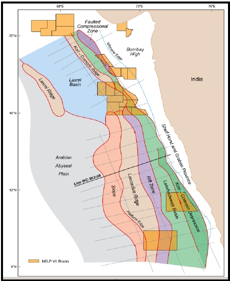
And what lies below? All this Eocene to Pleistocene (56 million to 2.5 million years) sediment sequence has been deposited on top of a Palaeocene-Eocene (66 million to 56 million years) volcanic basement. This basement is the northern part of the Chagos-Laccadive ridge, formed when the Indian plate rode over a hot area of the mantle known as the Reunion hotspot. Below the lava is Indian Precambrian continental crust. The foundation of the Chagos-Laccadive ridge is therefore a rifted sliver of continental crust separated from the west coast shelf margin during India's separation from Africa.
The map below summarizes the setting of the Chagos-Laccadive ridge with respect to the Indian shelf margin.

Source: Deepwater West Coast India - Pre-Basalt and Other Mesozoic Petroleum Plays: Glyn Roberts et al. 2010
Regarding Andamans.. This island chain are the central part of the Burma-Sunda-Java subduction complex in which an accretionary prism and deep sea turbidite deposits are exposed. This means the islands are made up of marine sediment and oceanic crust of a subducting slab (oceanic Indian plate) which got scraped off and plastered on to the overriding plate (oceanic South East Asian plate).
A tectonic cross section of the Andaman subduction complex is shown below.
 Source: Mud volcanoes show gas hydrates potential in India's Andaman Islands- Vignesh Ayyadurai et. al. 2015
Sediment and volcanic material and mafic igneous oceanic crust making up the Andaman chain may have started appearing above sea level from Eocene times (~50 million years ago). Eocene sediment of the Mithakari Group contains detritus derived from earlier Late Cretaceous -Early Eocene ophiolites (slices of oceanic crust). This indicates that ophiolite blocks were thrust up and were exposed above sea level and were being eroded. Such accretionary prism settings and forearc basins are cannibalistic, in that, the older deposits are emplaced above sea level and become a source of sediment for younger sequences. As tectonic plates continue to push against each other, these younger sequences in turn are moved upwards along thrust faults and become exposed above sea level. Certainly, by Pliocene times (5 million years to 2.5 million years ago), there would have been a large enough island chain.
I guess to the best of my knowledge the answer is that, although in the Lakshasdweep area, coral reef and atoll environments may be emerged above sea level episodically over the past tens of millions of years, as permanent land the Andamans are older.
One misconception I have encountered regarding Lakshadweep is that the Chagos-Laccadive ridge is a southerly extension of the Aravalli mountain chain.
This is not correct.
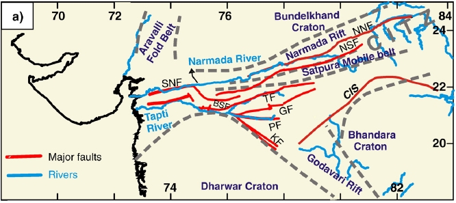
As I mentioned above, the basement of the ridge is likely Precambrain continental crust which rifted apart from the southerly west coast margin of India. So, the continental crust making up the ridge would have been part of the Southern Granulite Terrain and western Dharwar craton (craton- earliest formed pieces of continental crust going back more than 3 billion years ago) of south India. The Aravalli craton and the Southern Granulite Terrain / Dharwar craton were two distinct cratonic blocks which collided and sutured by early -mid Proterozoic times (2.5 billion to 1 billion years ago). The Chagos-Laccadive ridge is oriented NNW-SSE parallel to the Indian west coast shelf margin and the Dharwar structural trends. Post rifting, as the Indian western margin moved over the Renunion hot spot, volcanism covered this basement with lava, enhancing the ridge structure. The Chagos-Laccadive-Maldive ridge is a hotspot trail which marks the movement of the Indian plate above the Reunion hotspot.
One can imagine extending in an arcuate line the Aravalli mountain trend south to connect with the Chagos-Laccadive ridge.

Source: The Central India Tectonic Zone: A geophysical perspective on continental amalgamation along a Mesoproterozoic suture- K. Naganjaneyulu and M. Santosh 2010
But these were two different pieces of continental crust in the Archean. In the above figure the Dharwar and the Bhandara Cratons form a South Indian crustal block, while the Bundelkhand and Aravalli Fold Belt form the North Indian crustal block. The Aravalli mountains terminate north of the Central Indian Tectonic Zone (shown by roughly east-west trending fault lines). This is the suture zone between the North Indian and South Indian crustal blocks.
Which formed first, Andamans or Lakshadweep?
My answer was-
Lakshadweep islands, as a system of living coral reefs, lagoons and sparkling shell sand beaches, is Holocene in age (past 12 thousand years). These coral communities rest on earlier Pleistocene reefs. So, the history of exposed reefs and atolls is a Quaternary Period phenomenon going back several hundred thousand years. Periodic polar ice cap growth and melting drove sea level fluctuations, resulting in episodic shallow seas and vertical coral growth and reef building. Below these Pleistocene and Holocene corals lie earlier Cenozoic carbonate sediments (Source 1, 2 ) . These sediments were deposited in a subtidal marine setting, with reefs and sand shoal type environments prevailing from time to time.
We are not sure whether vertical coral growth during deposition of these earlier carbonate sequences created coral islands. It is possible that during this long Cenozoic history, there may have been episodic appearance of islands. Coral island systems and small sand shoals, environments lasting for thousands of years, would have developed due to vigorous coral growth and a static sea level, before being submerged again as sea level rose and drowned them.
And what lies below? All this Eocene to Pleistocene (56 million to 2.5 million years) sediment sequence has been deposited on top of a Palaeocene-Eocene (66 million to 56 million years) volcanic basement. This basement is the northern part of the Chagos-Laccadive ridge, formed when the Indian plate rode over a hot area of the mantle known as the Reunion hotspot. Below the lava is Indian Precambrian continental crust. The foundation of the Chagos-Laccadive ridge is therefore a rifted sliver of continental crust separated from the west coast shelf margin during India's separation from Africa.
The map below summarizes the setting of the Chagos-Laccadive ridge with respect to the Indian shelf margin.
Source: Deepwater West Coast India - Pre-Basalt and Other Mesozoic Petroleum Plays: Glyn Roberts et al. 2010
Regarding Andamans.. This island chain are the central part of the Burma-Sunda-Java subduction complex in which an accretionary prism and deep sea turbidite deposits are exposed. This means the islands are made up of marine sediment and oceanic crust of a subducting slab (oceanic Indian plate) which got scraped off and plastered on to the overriding plate (oceanic South East Asian plate).
A tectonic cross section of the Andaman subduction complex is shown below.

Sediment and volcanic material and mafic igneous oceanic crust making up the Andaman chain may have started appearing above sea level from Eocene times (~50 million years ago). Eocene sediment of the Mithakari Group contains detritus derived from earlier Late Cretaceous -Early Eocene ophiolites (slices of oceanic crust). This indicates that ophiolite blocks were thrust up and were exposed above sea level and were being eroded. Such accretionary prism settings and forearc basins are cannibalistic, in that, the older deposits are emplaced above sea level and become a source of sediment for younger sequences. As tectonic plates continue to push against each other, these younger sequences in turn are moved upwards along thrust faults and become exposed above sea level. Certainly, by Pliocene times (5 million years to 2.5 million years ago), there would have been a large enough island chain.
I guess to the best of my knowledge the answer is that, although in the Lakshasdweep area, coral reef and atoll environments may be emerged above sea level episodically over the past tens of millions of years, as permanent land the Andamans are older.
One misconception I have encountered regarding Lakshadweep is that the Chagos-Laccadive ridge is a southerly extension of the Aravalli mountain chain.
This is not correct.
As I mentioned above, the basement of the ridge is likely Precambrain continental crust which rifted apart from the southerly west coast margin of India. So, the continental crust making up the ridge would have been part of the Southern Granulite Terrain and western Dharwar craton (craton- earliest formed pieces of continental crust going back more than 3 billion years ago) of south India. The Aravalli craton and the Southern Granulite Terrain / Dharwar craton were two distinct cratonic blocks which collided and sutured by early -mid Proterozoic times (2.5 billion to 1 billion years ago). The Chagos-Laccadive ridge is oriented NNW-SSE parallel to the Indian west coast shelf margin and the Dharwar structural trends. Post rifting, as the Indian western margin moved over the Renunion hot spot, volcanism covered this basement with lava, enhancing the ridge structure. The Chagos-Laccadive-Maldive ridge is a hotspot trail which marks the movement of the Indian plate above the Reunion hotspot.
One can imagine extending in an arcuate line the Aravalli mountain trend south to connect with the Chagos-Laccadive ridge.
Source: The Central India Tectonic Zone: A geophysical perspective on continental amalgamation along a Mesoproterozoic suture- K. Naganjaneyulu and M. Santosh 2010
But these were two different pieces of continental crust in the Archean. In the above figure the Dharwar and the Bhandara Cratons form a South Indian crustal block, while the Bundelkhand and Aravalli Fold Belt form the North Indian crustal block. The Aravalli mountains terminate north of the Central Indian Tectonic Zone (shown by roughly east-west trending fault lines). This is the suture zone between the North Indian and South Indian crustal blocks.
Great article Suvrat. May I Ask which is the oldest river? Indus, ganges or brahmaputra? How do the ages of south indian rivers compare with north indian rivers?
ReplyDeleteThank you, Mohan
Hi Mohan- thanks...
ReplyDeletePaleo- Ganges, Brahmaputra would have originated as India collided with Asia in early Miocene as a southerly drainage evolved. Tectonic changes may have modified their courses but you can think of these big drainage systems as evolving by Miocene times. see my post on this : http://suvratk.blogspot.in/2016/03/sedimentation-patterns-bay-of-bengal.html
Indus may be the oldest of the three, since there is evidence that a paleo Indus was debouching sediment in the Katawaz delta in Pakistan (an earlier version of the Indus delta) by late Eocene times. see this : http://webapp1.dlib.indiana.edu/virtual_disk_library/index.cgi/2870166/FID3366/PDF/172.PDF
South Indian rivers are older, delivering sediment to the eastern Indian margin by Cretaceous times.
Thanks Suvrat. Is it also true that the western and eastern ghats are much older than the Himalayas and Vindhyas? Have you written a blog on western ghat geology? Also,are the mountains of Sri Lanka a continuation of the Indian ghats?
ReplyDeleteMohan
reg your question on Western Ghat geology blog - these two on the uplift history-
Deletehttp://suvratk.blogspot.in/2009/01/panchgani-tableland-informs-about.html and
http://suvratk.blogspot.in/2009/02/why-tea-grows-at-higher-elevations-than.html
As topographic features the Vindhyans are likely the oldest (although there may be some Negene rejuvenation), then the Eastern Ghats (Cretaceous-Eocene?), then the Western Ghats (beginning Eocene) and then the Himalaya (prominent topography beginning Miocene). although some workers say the Western Ghats show rejuvenation in the Neogene, so it has a Miocene and younger uplift component also.
ReplyDeleteSri Lanka has high grade metamorphic terrains which show a similarity with the Southern Granulite province of India. I am not sure if their topography development has anything to do with the Indian ghats.. future post? :)
Wow what an informative post. I never thought at such levels. Thanks for sharing :)
ReplyDeletethanks for reading Archana :)
ReplyDeletenice article Suvrat, very informative
ReplyDeletethanks for reading Animesh :)
ReplyDeleteVery informative. I just returned from Lakshadweep and I am worried about the aftermath of the reefs when plans of developing these islands on lines of maldives comes in.
ReplyDelete